|
Ethiopian Xeric Grasslands And Shrublands
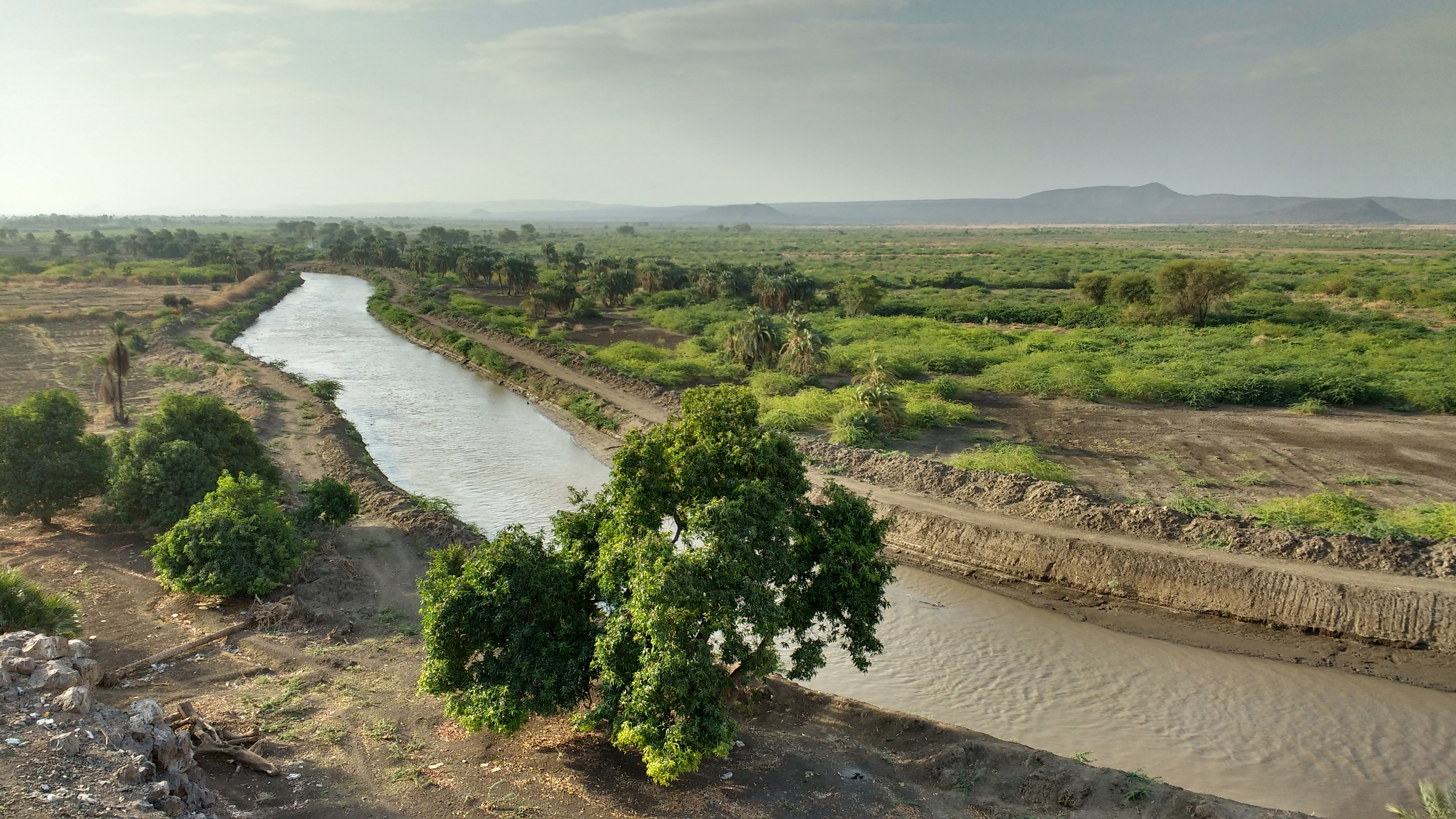
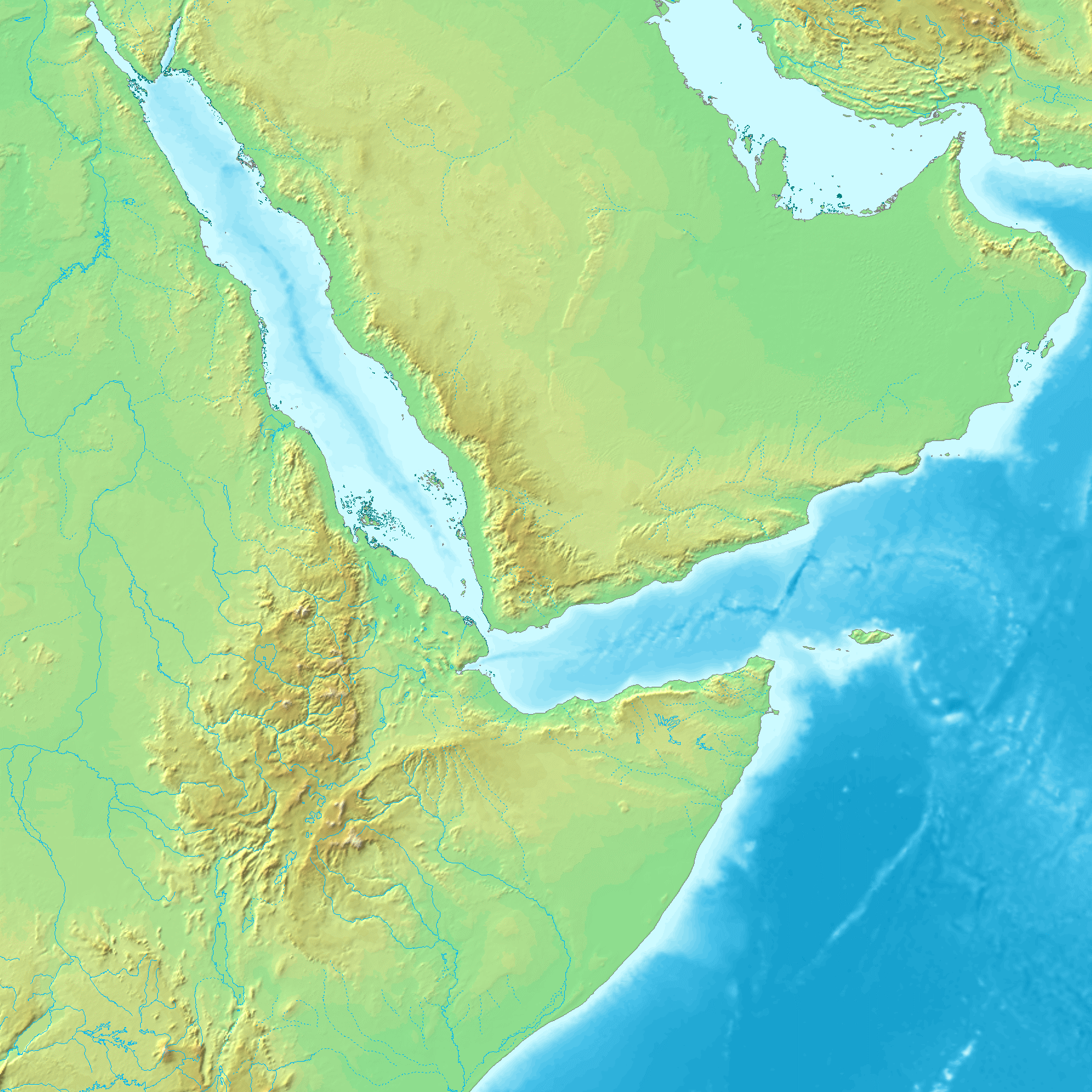
The Djibouti xeric shrublands is an ecoregion defined by One Earth, consisting of a semi-desert strip on or near the Red Sea and the Gulf of Aden coasts in Eritrea, Ethiopia, Djibouti and Somalia. This ecoregion lies mainly between sea level and 800 meters (m) elevation. There are, however, many hills and massifs, which range up to 1300 m as well as outstanding fault-induced depressions, such as the Danakil Depression, Danakil, lying as low as 155 m below sea level. This region is extremely active tectonically, experiencing many earthquakes and intermittently active volcanoes. Rainfall is very low and yearly averages range from 100 to 200 millimeters (mm), with less rain falling closer to the coast. There are many species of interest, including the endemic Archer's lark (''Heteromirafra archeri''), a species of dragon tree (''Dracaena ombet''), and a large suite of desert ungulates, including the last viable population of African wild ass (''Equus africanus somalicus''). Location ... [...More Info...] [...Related Items...] OR: [Wikipedia] [Google] [Baidu] |
Awash River
} The Awash River (sometimes spelled Awaash; Oromo language, Oromo: ''Awaash OR Hawaas'', Amharic: ዐዋሽ, Afar language, Afar: ''Hawaash We'ayot'', Somali language, Somali: ''Webiga Dir'', Italian language, Italian: ''Auasc'') is a major river of Ethiopia. Its course is entirely contained within the boundaries of Ethiopia and empties into a chain of interconnected lakes that begin with Lake Gargori and end with Lake Abbe (or Abhe Bad) on the border with Djibouti, about from the head of the Gulf of Tadjoura. The Awash River is the principal stream of an endorheic drainage basin covering parts of the Amhara Region, Amhara, Oromia and Somali Regions, as well as the southern half of the Afar Region. The Awash River basin, spanning 23 administrative zones, covers 10% of Ethiopia's area. The basin usually has two rainy seasons, a shorter one around March (''Belg''), and a longer one between June and September (''Kiremt''), which partly fall into one longer rainy season. Climate chan ... [...More Info...] [...Related Items...] OR: [Wikipedia] [Google] [Baidu] |
Gulf Of Aden
The Gulf of Aden (; ) is a deepwater gulf of the Indian Ocean between Yemen to the north, the Arabian Sea to the east, Djibouti to the west, and the Guardafui Channel, the Socotra Archipelago, Puntland in Somalia and Somaliland to the south. In the northwest, it connects with the Red Sea through the Bab-el-Mandeb strait, and it connects with the Arabian Sea to the east. To the west, it narrows into the Gulf of Tadjoura in Djibouti. The Aden Ridge lies along the middle of the gulf, and tectonic activity at the ridge is causing the gulf to widen by about per year. The ancient Greeks regarded the gulf as one of the most important parts of the " Erythraean Sea". It later came to be dominated by Muslims, as the area around the gulf converted to Islam. From the late 1960s onwards, there was an increased Soviet naval presence in the Gulf. The importance of the Gulf of Aden declined while the Suez Canal was closed, but it was revitalized when the canal was reopened in 1975, af ... [...More Info...] [...Related Items...] OR: [Wikipedia] [Google] [Baidu] |
Danakil Alps
The Danakil Alps are a highland region in Ethiopia and Eritrea with peaks over 1000 metres in height and a width varying between 40 and 70 kilometres. The area is known in the Afar language as Arrata. The alps lie along the southern Red Sea to the east of the Danakil Depression and separate it from the sea. The alps are asymmetric in cross-section with a comparatively gentle rift escarpment facing the Red Sea and intense normal faulting on the inland side. In the northern part of the alps the basement rock is less elevated and there are many volcanic edifices, such as those forming the Nabro Volcanic Range. The largest of the Nabro Volcanic Range edifices are the Mallahle, Nabro, and Dubbi. The volcanic range extends northwestward to the Red Sea, ending with the Kod Ali volcano offshore. The Danakil Alps have been cut off from the sea since the late Pleistocene. Composition Geologically these highlands are described as a horst and are sometimes referred to as the Danakil H ... [...More Info...] [...Related Items...] OR: [Wikipedia] [Google] [Baidu] |
Dahlak Archipelago
The Dahlak Archipelago is an Eritrean island group located in the Red Sea, measuring around 643 square km (248 square miles) and lying roughly 58 kilometers (31 nautical miles, 36 miles) east of Massawa, the regional capital city. Etymology The etymology of the name remains obscure. Al-Hamdani, al-Idrisi, and Yaqut used the form "dahlak," while Yaqut also recorded "dahlik." According to Yaqut and al-Idrisi, "dahlak" is a foreign word that became Arabicized. Moshe Piamenta states that "dahlak" means "big merchant." History G.W.B. Huntingford has identified with the Dahlak archipelago a group of islands near Adulis called "Alalaiou" in the '' Periplus of the Erythraean Sea'' which were a source of tortoise shell. According to Edward Ullendorff, the Dahlak islanders were amongst the first people in the Horn of Africa to embrace Islam, and a number of tombstones in Kufic script attest to this early connection. Relations between Abyssinia and the Dahlak Islands date ... [...More Info...] [...Related Items...] OR: [Wikipedia] [Google] [Baidu] |
Lake Awasa
Lake Hawassa or Awasa, is an endorheic basin in Sidama Region of Ethiopia, located in the Main Ethiopian Rift south of Addis Ababa, the capital city of the country. According to the ''Statistical Abstract of Ethiopia for 1967/68'', the lake is 16 km long and 9 km wide, with a surface area of 129 square kilometers. It has a maximum depth of 10 meters and is located at an elevation of 1,708 meters. It is located inside the Awasa Caldera. Because it is relatively accessible to scientists, Lake Hawassa is the most studied of the Rift Valley lakes in Ethiopia. According to William Taylor, a member of the African Lakes and Rivers Research Group at the University of Waterloo, Lake Hawassa is, despite its lack of an outflow, "essentially a freshwater lake (conductivity is variable, but less than 1,000) indicating that it must have a subterranean outlet." [...More Info...] [...Related Items...] OR: [Wikipedia] [Google] [Baidu] |
Great Rift Valley, Ethiopia
The Great Rift Valley of Ethiopia, (or Main Ethiopian Rift or Ethiopian Rift Valley) is a branch of the East African Rift that runs through Ethiopia in a southwest direction from the Afar triple junction. In the past, it was seen as part of a "Great Rift Valley" that ran from Mozambique to Syria. Known for its scenery and diverse wildlife in Ethiopia specifically the Rift Valley holds importance in the field of human evolution. It is recognized as an area for researching the stages of human development with crucial fossil findings such, as Lucy (Australopithecus afarensis) unearthed within its bounds. Description The Great Rift Valley lies between the Ethiopian Plateau to the north and the Somalia Plateau to the south. The rift developed as the Nubian and Somali plates began to separate during the Miocene Period along the East African rift system. Rift initiation was asynchronous along the Ethiopian rift valley: deformation began around 18 million years ago at the south end, ... [...More Info...] [...Related Items...] OR: [Wikipedia] [Google] [Baidu] |
Ethiopian Highlands
The Ethiopian Highlands (also called the Abyssinian Highlands) is a rugged mass of mountains in Ethiopia in Northeast Africa. It forms the largest continuous area of its elevation in the continent, with little of its surface falling below , while the summits reach heights of up to . It is sometimes called the "Roof of Africa" due to its height and large area. It is the only country in the region with such a high elevated surface. This elevated surface is bisected diagonally by the Great East African Rift System which extends from Syria to Mozambique across the East African Lakes. Most of the Ethiopian Highlands are part of central and northern Ethiopia, and its northernmost portion reaches into Eritrean Highlands, Eritrea. History In the southern parts of the Ethiopian Highlands once was located the Kingdom of Kaffa, a medieval and Early modern period, early modern state, whence the coffee plant was exported to the Arabian Peninsula. The land of the former kingdom is mountainou ... [...More Info...] [...Related Items...] OR: [Wikipedia] [Google] [Baidu] |
Afar Triangle
The Afar Triangle (also called the Afar Depression) is a geological depression caused by the Afar triple junction, which is part of the Great Rift Valley in East Africa. The region has disclosed fossil specimens of the very earliest hominins; that is, the earliest of the human clade, and it is thought by some paleontologists to be the cradle of the evolution of humans. The Depression overlaps the borders of Eritrea, Djibouti and the entire Afar Region of Ethiopia; and it contains the lowest point in Africa, Lake Assal, Djibouti, at below sea level. The Awash River is the main waterflow into the region, but it runs dry during the annual dry season, and ends as a chain of saline lakes. The northern part of the Afar Depression is also known as the Danakil Depression. The lowlands are affected by heat, drought, and minimal air circulation, and contain the hottest places (year-round average temperatures) of anywhere on Earth. The Afar Triangle is bordered as follows (see the topo ... [...More Info...] [...Related Items...] OR: [Wikipedia] [Google] [Baidu] |
Somaliland
Somaliland, officially the Republic of Somaliland, is an List of states with limited recognition, unrecognised country in the Horn of Africa. It is located in the southern coast of the Gulf of Aden and bordered by Djibouti to the northwest, Ethiopia to the south and west, and Somalia to the east. Its claimed territory has an area of , with approximately 6.2 million people as of 2024. The capital and largest city is Hargeisa. Various Somali Muslim kingdoms were established in the area during the early Islamic period, including in the 14th to 15th centuries the Zeila-based Adal Sultanate. In the early modern period, successor states to the Adal Sultanate emerged, including the Isaaq Sultanate which was established in the middle of the 18th century. In the late 19th century, the United Kingdom signed agreements with various clans in the area, establishing the British Somaliland, Somaliland Protectorate, which was formally granted independence by the United Kingdom as the Sta ... [...More Info...] [...Related Items...] OR: [Wikipedia] [Google] [Baidu] |
African Wild Ass
The African wild ass (''Equus africanus'') or African wild donkey is a wild member of the horse family, Equidae. This species is thought to be the ancestor of the domestic donkey (''Equus asinus''), which is sometimes placed within the same species. They live in the deserts and other arid areas of the Horn of Africa, in Eritrea, Ethiopia Ethiopia, officially the Federal Democratic Republic of Ethiopia, is a landlocked country located in the Horn of Africa region of East Africa. It shares borders with Eritrea to the north, Djibouti to the northeast, Somalia to the east, Ken ... and Somalia. It formerly had a wider range north and west into Sudan, Egypt, and Libya. It is Critically Endangered, with about 570 existing in the wild. Description The African wild ass is about tall and weighs approximately . The short, smooth coat is a light grey to fawn colour, fading quickly to white on the undersides and legs. There is a slender, dark dorsal stripe in all subspecie ... [...More Info...] [...Related Items...] OR: [Wikipedia] [Google] [Baidu] |
Desert
A desert is a landscape where little precipitation occurs and, consequently, living conditions create unique biomes and ecosystems. The lack of vegetation exposes the unprotected surface of the ground to denudation. About one-third of the land surface of the Earth is arid or Semi-arid climate, semi-arid. This includes much of the Polar regions of Earth, polar regions, where little precipitation occurs, and which are sometimes called polar deserts or "cold deserts". Deserts can be classified by the amount of precipitation that falls, by the temperature that prevails, by the causes of desertification or by their geographical location. Deserts are formed by weathering processes as large variations in temperature between day and night strain the Rock (geology), rocks, which consequently break in pieces. Although rain seldom occurs in deserts, there are occasional downpours that can result in flash floods. Rain falling on hot rocks can cause them to shatter, and the resulting frag ... [...More Info...] [...Related Items...] OR: [Wikipedia] [Google] [Baidu] |
Dracaena Ombet
''Dracaena ombet'', commonly known as Gabal Elba dragon tree, is a species of plant belonging to the Asparagaceae family, formerly included in the Ruscaceae. It is found in northeastern Africa and the western Arabian Peninsula. Description It is a tree that reaches a size of 2–8 m in height, with a forked trunk that produces a red resin. The leaves form dense rosettes at the ends of the branches, these are linear with a broad base, 40–60 x up to 3 cm, gradually tapering to the tip that is sharp, thick and rigid, with smooth margins, flat to concave in the top. The inflorescence is panicle-shaped, 0.5 m long, highly branched, glabrous or pubescent, with tiny, ovate-lanceolate bracts. Whitish tepals, 4–6 mm long, are linear. Stamens are somewhat shorter than tepals; flattened filaments. The fruit in the form of berries 10–12 mm in diameter. Distribution It is found at an altitude of 1000–1800 m in Djibouti, Eritrea, Ethiopia, Somalia ... [...More Info...] [...Related Items...] OR: [Wikipedia] [Google] [Baidu] |


