|
Ennucula Aegeensis
''Ennucula aegeensis'', commonly known as the Aegean nut clam, is a nut clam present in the Atlantic Ocean, Gulf of Mexico, and the Mediterranean. Distribution ''Ennucula aegeensis'' is present of the coast of Florida, North Carolina, West Indies, Gulf of Mexico, and the Mediterranean (Sea of Marmara, Marmara, Aegean Sea, Aegean, and Levantine Sea). ''E. aegeensis'' in the Mediterranean is typically found 80–500 m under the sea, its lower limit is around 1000 m. However, under 500–600 m it is usual replaced by ''E. corbuloides''. ''E. aegeensis'' occupies muddy sandy-bottoms. ''E. aegeensis'' fossils have been found near the islet of Sokastro dating back to the early Calabrian (stage), Calabrian (1.7-1.6 Mega-annum, Ma). Description ''Ennucula aegeensis'' has an obliquely oval, white, shell. That has fine conmarginal striae on the exterior, the interior as radially ribbed structures that appear as fine radial striations. The interior margins are minutely wikt:denticulate, ... [...More Info...] [...Related Items...] OR: [Wikipedia] [Google] [Baidu] |
Sea Of Marmara
The Sea of Marmara,; grc, Προποντίς, Προποντίδα, Propontís, Propontída also known as the Marmara Sea, is an inland sea located entirely within the borders of Turkey. It connects the Black Sea to the Aegean Sea via the Bosporus and Dardanelles straits, separating the country's European and Asian sides. The Sea of Marmara is a small sea with an area of , and dimensions of . Its greatest depth is . Name The Sea of Marmara is named after the largest island to its south side which is called Marmara Island because it is rich in marble (Greek (''mármaron'') "marble)." In classical antiquity it was known as the Propontis, which is derived from the Greek words ''pro-'' (before) and ''pontos'' (sea) and reflects the fact that the Ancient Greeks used to sail through it to reach the Black Sea that they called Pontos. Mythology In Greek mythology, a storm on the Propontis brought the Argonauts back to an island they had left, precipitating a battle in whic ... [...More Info...] [...Related Items...] OR: [Wikipedia] [Google] [Baidu] |
Aegean Sea
The Aegean Sea ; tr, Ege Denizi (Greek: Αιγαίο Πέλαγος: "Egéo Pélagos", Turkish: "Ege Denizi" or "Adalar Denizi") is an elongated embayment of the Mediterranean Sea between Europe and Asia. It is located between the Balkans and Anatolia, and covers an area of some 215,000 square kilometres. In the north, the Aegean is connected to the Marmara Sea and the Black Sea by the straits of the Dardanelles and the Bosphorus. The Aegean Islands are located within the sea and some bound it on its southern periphery, including Crete and Rhodes. The sea reaches a maximum depth of 2,639m to the west of Karpathos. The Thracian Sea and the Sea of Crete are main subdivisions of the Aegean Sea. The Aegean Islands can be divided into several island groups, including the Dodecanese, the Cyclades, the Sporades, the Saronic islands and the North Aegean Islands, as well as Crete and its surrounding islands. The Dodecanese, located to the southeast, includes the islands of R ... [...More Info...] [...Related Items...] OR: [Wikipedia] [Google] [Baidu] |
Levantine Sea
The Levantine Sea (Arabic: بحر الشام, tr, Levanten Denizi, el, Θάλασσα του Λεβάντε) is the easternmost part of the Mediterranean Sea. Geography The Levantine Sea is bordered by Turkey in the north and north-east corner, Syria, Lebanon, Israel, and Palestine in the east, Egypt in the south, and the Aegean Sea in the northwest. Where it is used as a term its western border is amorphous, hence Mediterranean is more commonly used. The open western border to the next part of the Mediterranean (the Libyan Sea) is defined as a line from headland Ras al-Helal in Libya to Gavdos, south of the western half of Crete. The largest island in its subset of water is Cyprus. The greatest depth of is found in the Pliny Trench, about south of Crete. The Levantine Sea covers . The northern part of the Levantine Sea between Cyprus and Turkey can be further specified as the Cilician Sea, a term more arcane. Also in the north are two large bays, the Gulf of İske ... [...More Info...] [...Related Items...] OR: [Wikipedia] [Google] [Baidu] |
Calabrian (stage)
Calabrian is a subdivision of the Pleistocene Epoch of the geologic time scale, defined as 1.8 Ma—774,000 years ago ± 5,000 years, a period of ~. The end of the stage is defined by the last magnetic pole reversal (781 ± 5 Ka) and plunge into an ice age and global drying possibly colder and drier than the late Miocene ( Messinian) through early Pliocene (Zanclean) cold period. Originally the Calabrian was a European faunal stage primarily based on mollusk fossils. It has become the second geologic age in the Early Pleistocene. Many of the mammalian faunal assemblages of the Early Pleistocene start in the Gelasian. For example, the Platygonus and other Blancan fauna appear first in the Gelasian. History of the definition of the Calabrian Because sea shells are much more abundant as fossils, 19th- and early-20th-century geo-scientists used the plentiful and well-differentiatable Mollusca (mollusks) and Brachiopods to identify stratigraphic boundaries. Thus the Calabrian ... [...More Info...] [...Related Items...] OR: [Wikipedia] [Google] [Baidu] |
Mega-annum
A year or annus is the orbital period of a planetary body, for example, the Earth, moving in its orbit around the Sun. Due to the Earth's axial tilt, the course of a year sees the passing of the seasons, marked by change in weather, the hours of daylight, and, consequently, vegetation and soil fertility. In temperate and subpolar regions around the planet, four seasons are generally recognized: spring, summer, autumn and winter. In tropical and subtropical regions, several geographical sectors do not present defined seasons; but in the seasonal tropics, the annual wet and dry seasons are recognized and tracked. A calendar year is an approximation of the number of days of the Earth's orbital period, as counted in a given calendar. The Gregorian calendar, or modern calendar, presents its calendar year to be either a common year of 365 days or a leap year of 366 days, as do the Julian calendars. For the Gregorian calendar, the average length of the calendar year (the mean ... [...More Info...] [...Related Items...] OR: [Wikipedia] [Google] [Baidu] |
Denticulate
{{disambiguation ...
Denticulate is an adjective referring to something having teeth-like structures. It may refer to: * Denticulate tool, a type of stone tool in archeology * Denticulate leaf, a leaf with finely toothed margins * Denticulate ligaments, in human anatomy * a type of conodont prehistoric fish, characterized by the sideward orientation of the major teeth-like projections (denticulate processes) See also * Dentate (other) Dentate may refer to: * A species having dentition * An energy-dissipating baffle block in a spillway * An individual not being edentulous * Dentate gyrus of the hippocampus * Dentate nucleus of the cerebellum * Denticity in chemistry * Denta ... [...More Info...] [...Related Items...] OR: [Wikipedia] [Google] [Baidu] |
Endobenthic
Benthos (), also known as benthon, is the community of organisms that live on, in, or near the bottom of a sea, river, lake, or stream, also known as the benthic zone.Benthos from the Census of Antarctic Marine Life website This community lives in or near marine or freshwater sedimentary environments, from s along the , out to the [...More Info...] [...Related Items...] OR: [Wikipedia] [Google] [Baidu] |
Seafloor Sediment
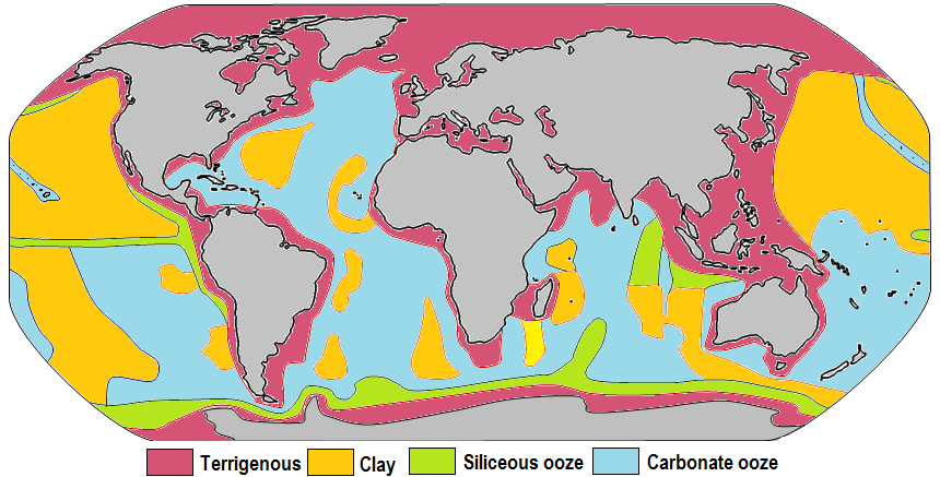
Marine sediment, or ocean sediment, or seafloor sediment, are deposits of insoluble particles that have accumulated on the seafloor. These particles have their origins in soil and rocks and have been transported from the land to the sea, mainly by rivers but also by dust carried by wind and by the flow of glaciers into the sea. Additional deposits come from marine organisms and chemical precipitation in seawater, as well as from underwater volcanoes and meteorite debris. Except within a few kilometres of a mid-ocean ridge, where the volcanic rock is still relatively young, most parts of the seafloor are covered in sediment. This material comes from several different sources and is highly variable in composition. Seafloor sediment can range in thickness from a few millimetres to several tens of kilometres. Near the surface seafloor sediment remains unconsolidated, but at depths of hundreds to thousands of metres the sediment becomes lithified (turned to rock). Rates of sedimen ... [...More Info...] [...Related Items...] OR: [Wikipedia] [Google] [Baidu] |
Nuculidae
Nuculidae is a family of small saltwater clams in the order Nuculida. Species in this family are commonly known as nut clams. The nomenclature of the Western European species in this family is still uncertain. Their systematics has been based mainly on their feces.WoRMS (2011). Nuculidae. Accessed through: World Register of Marine Species at http://www.marinespecies.org/aphia.php?p=taxdetails&id=204 on 2011-05-04 Genera * ''Acila'' H. Adams and A. Adams, 1858 * '' Adrana'' Adams and Adams, 1858 * '' Austronucula'' Powell, 1939 * '' Brevinucula'' Thiele, 1934 * ''Condylonucula'' D.R. Moore, 1977 * ''Ennucula'' Iredale, 1931 *'' Lamellinucula'' Schenck, 1944 * '' Leionucula'' Quenstedt, 1930 † * '' Linucula'' Marwick, 1931 * '' Neonucula'' Lan & Lee, 2001 * ''Nucula'' Lamarck Jean-Baptiste Pierre Antoine de Monet, chevalier de Lamarck (1 August 1744 – 18 December 1829), often known simply as Lamarck (; ), was a French naturalist, biologist, academic, and soldi ... [...More Info...] [...Related Items...] OR: [Wikipedia] [Google] [Baidu] |


