|
Districts Of American Samoa
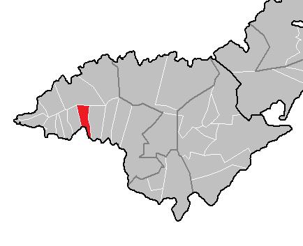
American Samoa is administratively divided into three districts (Western, Eastern and Manua) and two unorganized atolls ( Swains Island and Rose Atoll). The districts are subdivided into 15 counties, which are composed of 76 villages.118th Congress of the United States, American Samoa United States Census Bureau. For statistical purposes, the counts the three districts and two unorganized atolls as five , while treating the actual counti ... [...More Info...] [...Related Items...] OR: [Wikipedia] [Google] [Baidu] |
Western District, American Samoa
The Western District is one of the three primary divisions of American Samoa. It consists of the western portion of Tutuila Island. It has a land area of and contains 29 villages plus a part of Nuʻuuli village. Among these is the largest village of American Samoa, Tafuna, at its eastern end. The district's total population as of the 2010 census was 31,329. In addition to the western half of Tutuila Island, the Western District also includes several smaller islets, such as Taputapu Island, Toatai Rock, Niuolepava Rock, Utumatuu Rock, Liuvaatoga Rock, Luania Rocks, Manuelo Rock, and Nuutavana Rock. Dental and medical care to residents of the Western District are offered by Tafuna Community Health Center. History The island of Tutuila was historically divided into nine traditional "counties" known as ''faalupega''. The western counties were collectively referred to as Fofō and Aitulagi (also called Falelima Sisifo). In the early 20th century, American Samoa's first Governor, ... [...More Info...] [...Related Items...] OR: [Wikipedia] [Google] [Baidu] |
Afao
Afao is a village in southwest Tutuila Island, American Samoa. It is located on the island's short southwestern coast, between 'Amanave and Leone, to the southwest of Pago Pago. It includes the settlement of Atauloma. Afao is home to two places listed on the U.S. National Register of Historic Places: Afao Beach Site and Atauloma Girls School. In 1899, the London Missionary Society (LMS) started to raise funds to construct a girls’ school at Atauloma, and after $10,000 had been collected, Commandant Benjamin Franklin Tilley was invited to lay the cornerstone of its concrete structure. The girls' school was constructed in 1900 as the second secondary school on Tutuila Island Tutuila is the largest and most populous island of American Samoa and is part of the archipelago of the Samoan Islands. It is the third largest island in the Samoan Islands chain of the Pacific Ocean, Central Pacific. It is located roughly north ..., and the first school on the island to accept female s ... [...More Info...] [...Related Items...] OR: [Wikipedia] [Google] [Baidu] |
Nua, American Samoa
Nua is a village located in Lealataua County within the Western District of American Sāmoa. Serving as the administrative center for the administrative unit called Samatua, Nua is part of a region that includes several small localities situated between Leone and the western cape along the southwestern-facing bay. These localities comprise Nua, Seʻetaga, Faʻilolo, ʻAmanave, and Afao. Samatua consists of six towns and translates to “Elder”. History On October 5, 1890, the steamship ''Alameda'' made a stop near the island of Tutuila. Among its passengers were Henry Adams, an American historian and writer, John La Farge, a renowned artist, and Rioza Awoki, a Japanese traveler. The trio disembarked and boarded a small schooner. They had plans of visiting Apia, however, adverse weather conditions forced them to alter their course, leading them to the harbor at Nua, where they spent their first night. During their stay in Nua, they encountered Wakea, a ceremonial village ma ... [...More Info...] [...Related Items...] OR: [Wikipedia] [Google] [Baidu] |
Agugulu
Agugulu is a village on the southwest coast of Tutuila Island, American Samoa American Samoa is an Territories of the United States, unincorporated and unorganized territory of the United States located in the Polynesia region of the Pacific Ocean, South Pacific Ocean. Centered on , it is southeast of the island count .... It is located close to 'Amanave, not far from the island's western tip. It is located in Lealataua County. Demographics References Villages in American Samoa {{AmericanSamoa-geo-stub ... [...More Info...] [...Related Items...] OR: [Wikipedia] [Google] [Baidu] |
Poloa, American Samoa
Poloa is a village in American Samoa. It is located at the west side of Tutuila in the Alataua District. The village has 193 residents in 2010. The main denominations in the area are Methodist and Christian. Poloa has one elementary school. It is located in Lealataua County. Poloa is at the western terminus of American Samoa Highway 001. It is situated on a narrow coastal plain on Tutuila Island's western tip, west of Pago Pago. The village is made up of wood-frame homes and traditional fales. A school is located at the shoreline, approximately south of the village center. This elementary school has an enrollment of around 160 and also serves Poloa's neighboring villages. Due to the village's flatlands being ideal for development, the school was erected near the shore. Etymology The name ''Poloa'' denotes that once the sun sets over the horizon, it will immediately become dark, or Po-loa. The name originated from a premodern account of the travels of the legendary twins Taem ... [...More Info...] [...Related Items...] OR: [Wikipedia] [Google] [Baidu] |


