|
Departments Of Benin
Benin is divided into 12 Department (subnational entity), departments (French: ''départements''), and subdivided into 77 commune (subnational entity), communes (see Communes of Benin). In 1999, the previous six departments were each split into two halves, forming the current 12. Each of the six new departments was assigned a capital in 2008. See also * Communes of Benin * Arrondissements of Benin * ISO 3166-2:BJ, the International Organization for Standardization, ISO codes for the departments of Benin. References External links * * http://www.ambassade-benin.org/article20.html *Projections De La Population Du Benin Par Departement Departments of Benin, Subdivisions of Benin Lists of administrative divisions, Benin, Departments Administrative divisions in Africa, Benin 1 First-level administrative divisions by country, Departments, Benin Benin geography-related lists {{Benin-stub ... [...More Info...] [...Related Items...] OR: [Wikipedia] [Google] [Baidu] |
Allada
Allada is a town, arrondissement, and commune, located in the Atlantique Department of Benin. The current town of Allada corresponds to Great Ardra (also called Grand Ardra, or Arda), which was the capital of a Fon kingdom also called Allada (the '' kingdom of Ardra'' or ''kingdom of Allada''), which existed as a sovereign kingdom from around the 13th or 14th century (date of the initial settlements by Aja people, reorganized as a kingdom c. 1600) until 1724, when it fell to the armies of neighbour Kingdom of Dahomey. The present-day commune of Allada covers an area of 381 square kilometres and as of 2013 had a population of 127,512 people. History In the mid-sixteenth century, Allada (then called Grand Ardra, or Arda) had a population of about 30,000 people. The original inhabitants of Ardra were ethnic Aja. According to oral tradition, the Aja migrated to southern Benin around the 12th or 13th century, coming from Tado, on the Mono River in modern Togo. They established ... [...More Info...] [...Related Items...] OR: [Wikipedia] [Google] [Baidu] |
Plateau Department
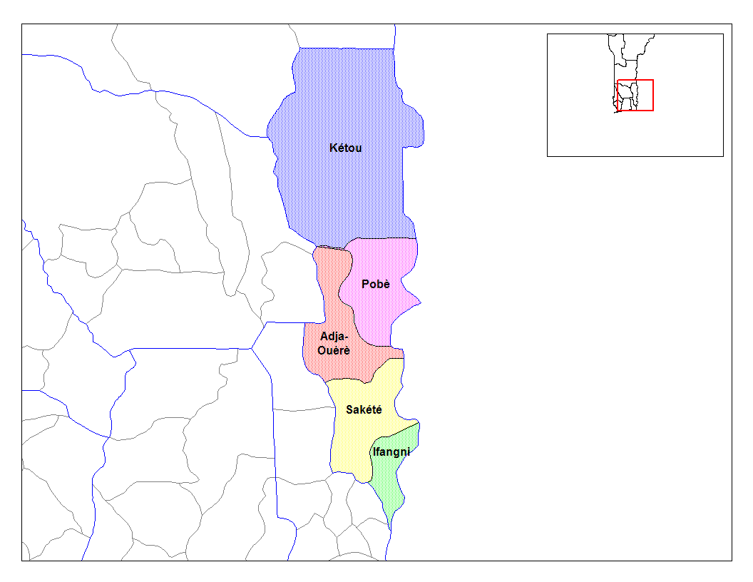
Plateau is one of the twelve departments of Benin. The department of Plateau was created in 1999 with an area of when it was split off from Ouémé Department. Plateau is subdivided into five communes, each centred at one of the principal towns: Adja-Ouèrè, Ifangni, Kétou, Pobè and Sakété. , the total population of the department was 622,372, with 300,065 males and 322,307 females. The proportion of women was 51.80%. The total rural population was 54.80%, while the urban population was 45.20%. The total labour force in the department was 185,815, of which 43.10% were women. The proportion of households with no level of education was 65.50%. Geography Plateau Department border Collines Department to the north, Nigeria to the east, Ouémé Department to the southwest, and Zou Department to the west. It is characterised by plateaus ranging from above the mean sea level. The plateaus are split by valleys running from north to south, created by the Iguidi river. The r ... [...More Info...] [...Related Items...] OR: [Wikipedia] [Google] [Baidu] |
Porto-Novo
, , ; ; ; also known as Hogbonu and Ajashe) is the Capital (political), capital and List of cities in Benin, second-largest city of Benin. The commune covers an area of and as of 2002 had a population of 223,552 people. In 1863, following British bombardment, Porto-Novo accepted French protection, and by 1900, it became the capital of French Dahomey. After Benin's independence in 1960, Porto-Novo retained its status as the official capital, while Cotonou emerged as the economic and administrative hub. Situated on an inlet of the Gulf of Guinea, in the southeastern portion of the country, the city was originally developed as a port for the Transatlantic Slave Trade, transatlantic History of slavery, slave trade led by the Portuguese Empire. It is Benin's second-largest city, and although it is the official capital, where the national legislature sits, the larger city of Cotonou is the seat of government, where most of the government buildings are situated and government departm ... [...More Info...] [...Related Items...] OR: [Wikipedia] [Google] [Baidu] |
Ouémé Department
Ouémé is one of the twelve departments of Benin, containing the capital of the country Porto Novo, named for the Ouémé River. It is subdivided into nine communes, each centred at one of the principal towns: Adjarra, Adjohoun, Aguégués, Akpro-Missérété, Avrankou, Bonou, Dangbo, Porto-Novo and Sèmè-Kpodji. In 1999, the northern section of Ouémé was split off to form the department of Plateau Department, Plateau. , the total population of the department was 1,100,404, with 534,814 males and 565,590 females. The proportion of women was 51.40%. The total rural population was 37.20%, while the urban population was 62.80%. The total labor force in the department was 383,716, of which 49.50% were women. The proportion of households with no level of education was 43.80% and the proportion of households with children attending school was 81.70%. Geography Ouémé Department borders Zou Department to the north, Plateau Department to the northeast, Nigeria to the southeast, t ... [...More Info...] [...Related Items...] OR: [Wikipedia] [Google] [Baidu] |
Lokossa
Lokossa is an arrondissement, commune, and the capital city of Mono Department in Benin. The name Lokossa translates into English as "underneath the iroko Iroko (Yoruba language, Yoruba: Ìrókò) is a large hardwood tree from the west coast of tropical Africa that can live up to 500 years. This is the common name for the genus ''Milicia'', in which there are two recognized species, which are close ... tree". The commune covers an area of and as of 2002 had a population of 77,065 people. References Communes of Benin Arrondissements of Benin Populated places in the Mono Department {{MonoDepartment-geo-stub ... [...More Info...] [...Related Items...] OR: [Wikipedia] [Google] [Baidu] |
Cotonou
Cotonou (; ) is the largest city in Benin. Its official population count was 679,012 inhabitants in 2012; however, over two million people live in the larger urban area. The urban area continues to expand, notably toward the west. The city lies in the southeast of the country, between the Atlantic Ocean and Lake Nokoué. Cotonou is the seat of government in Benin, although Porto-Novo is the official capital. History The name "Cotonou" means "by the river of death" in the Fon language.Butler, Stuart (2019) ''Bradt Travel Guide - Benin'', pgs. 74-91 At the beginning of the 19th century, Cotonou (then spelled "Kutonou") was a small fishing village, and is thought to have been formally founded by King Ghezo of Dahomey in 1830. It grew as a centre for the History of slavery, slave trade, and later palm oil and cotton. In 1851 the French Second Republic made a treaty with King Ghezo that allowed them to establish a trading post at Cotonou. During the reign of King Glele (1858–89), ... [...More Info...] [...Related Items...] OR: [Wikipedia] [Google] [Baidu] |
Djougou
Djougou is the largest city in northwestern Benin. It is an important market town. The commune covers an area of 3,966 square kilometres and as of 2002 had a population of 237.040 people. Djougou is home to a constituent monarchy. General information The city of Djougou is the capital city of the department of the Donga, and is considered to be the commercial capital of the Atacora-Donga region, with Natitingou acting as the seat of government and the primary tourist city. Djougou has a population of over 237,000 according to 2009 recensement . While Dendi language, Dendi is the primary language and ethnic group in Djougou, there are also a number of Fulani (Peul in French), Yoruba people, Yoruba, Bariba people, Bariba, as well as transplanted Fon people, Fon from the South. Like most of Benin, Djougou has a young and growing population. Large families and multiple wives are common—leading to a large number of young and school-aged children and pregnant women. There are many d ... [...More Info...] [...Related Items...] OR: [Wikipedia] [Google] [Baidu] |
Donga Department
Donga is one of the twelve departments of Benin; its capital is Djougou, the fourth largest city in the country. The department of Donga was created in 1999 when it was split off from Atakora Department. Donga is subdivided into five communes, each centered at one of the principal towns: Bassila, Copargo, Djougou Rural, Djougou Urban and Ouaké. , the total population of the department was 543,130, with 270,754 males and 272,376 females. The proportion of women was 50.10%. The total rural population was 57.90%, while the urban population was 42.10%. The total labour force in the department was 120,021, of which 24.20% were women. The proportion of households with no level of education was 72.50%. Geography Donga Department, with an area of , is located in north-central Benin, bordering Atakora Department to the north, Borgou Department to the east, Collines Department to the south, and Togo to the west. The northwest region of Benin consists mostly of forested mount ... [...More Info...] [...Related Items...] OR: [Wikipedia] [Google] [Baidu] |
Aplahoué
Aplahoué is a town and arrondissement in Benin Benin, officially the Republic of Benin, is a country in West Africa. It was formerly known as Dahomey. It is bordered by Togo to the west, Nigeria to the east, Burkina Faso to the north-west, and Niger to the north-east. The majority of its po ..., and is the capital of the Kouffo Department. The commune covers an area of 572 square kilometres and as of 2013 had a population of 170,069 people. References Communes of Benin Arrondissements of Benin Populated places in the Kouffo Department {{KouffoDepartment-geo-stub ... [...More Info...] [...Related Items...] OR: [Wikipedia] [Google] [Baidu] |
Kouffo Department
Kouffo or Couffo is one of the twelve departments of Benin. Kouffo borders the country of Togo and the departments of Mono, Zou and Atlantique. Since 2008, the department's capital has been Aplahoué. The department of Kouffo was created in 1999 when it was split off from Mono Department. , the total population of the department was 745,328, with 348,574 males and 396,754 females. The proportion of women was 53.20%. The total rural population was 72.20%, while the urban population was 27.80%. The total labour force in the department was 208,974, of which 52.60% were women. The proportion of households with no level of education was 68.60%. Geography Kouffo Department border Zou Department to the north, Atlantique Department to the east, Mono Department to the south, and Togo to the west. The department is characterised by plateaus ranging from above the mean sea level, which are split by valleys running from north to south created by the Sahoua River and Couffo Riv ... [...More Info...] [...Related Items...] OR: [Wikipedia] [Google] [Baidu] |
Dassa-Zoumé
Dassa-Zoumé , also known as Igbó Ìdàáshà or simply Dassa, is a city in central Benin, on the Cotonou-to- Parakou railway and the main north-south highway. It is the capital of Collines Department. The commune covers an area of , and as of 2013 had a population of 112,118. Jama'at Islamique Ahmadiyya Benin built its central mosque (Mosquée Moubarqiue) here in 2010, which has a tall 18-meter minaret, just outside the city on the main road towards Parakou. Jama'at Islamique Ahmadiyya Benin also built a French/English bilingual primary school here, called Ecole Primaire Publique Ahmadiyya. The indigenous population of Dassa are the Idaasha. They migrated from the Egba subgroup of western Yoruba in present-day Nigeria to settle here. The city is known as a place of pilgrimage; the Virgin Mary is said to have appeared in the Grotte Notre-Dame d'Arigbo, around which a basilica has since been built containing several shrines.Butler, Stuart (2019) ''Bradt Travel Guide - Benin ... [...More Info...] [...Related Items...] OR: [Wikipedia] [Google] [Baidu] |


