|
Waterfalls Of Oregon
There are at least 238 waterfalls in the U.S. state of Oregon. See also * List of waterfalls * Lists of Oregon-related topics {{United States topic, navbar=plain, title=List of waterfalls#United States, Waterfalls in the United States, prefix=List of waterfalls in Lists of waterfalls in the United States, Oregon Lists of landforms of Oregon, Waterfalls Waterfalls of Oregon, ... [...More Info...] [...Related Items...] OR: [Wikipedia] [Google] [Baidu] |
Barr Creek Falls
Barr Creek Falls, is a waterfall located in the Rogue River Canyon within the Prospect State Scenic Viewpoint in Jackson County, Oregon, Jackson County, in the U.S. state of Oregon. The waterfall is located at the south end of Barr Creek as it plunges into the Rogue River over a carved cliff surrounded by walls of petrified volcanic ash as a consequence of the Mount Mazama eruption. The waterfall has also been called Bear Creek Falls. The waterfall gets its name from the creek which was called "Barr" for the presence of a fence that prevented cattle from straying out of the local Red Blanket Ranch and that ran adjacent to the creek. Description Barr Creek Falls shares the same rock cliff with Mill Creek Falls. Both waterfalls can be seen next to each other from their respective viewpoints. The fall drops in three major steps. First plummets 60-feet, which is not a visible section of the cascade from the trail viewpoint. The second tier drops down another 30 feet, which is half v ... [...More Info...] [...Related Items...] OR: [Wikipedia] [Google] [Baidu] |
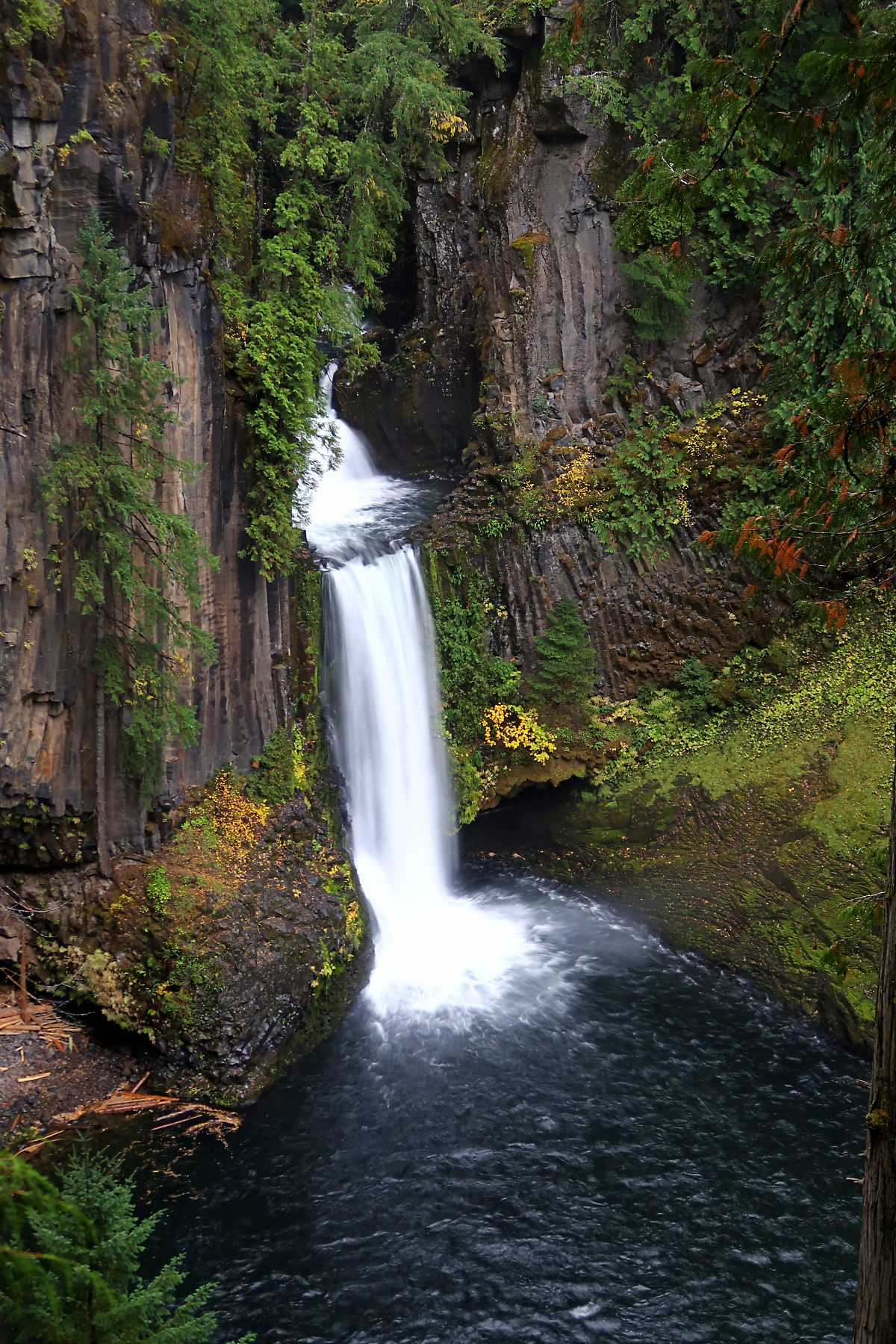
Toketee Falls (5836521270)
Toketee Falls is a waterfall in Douglas County, Oregon, United States, on the North Umpqua River at its confluence with the Clearwater River. It is located approximately east of Roseburg near Oregon Route 138, northwest of the North Entrance to Crater Lake. ''Toketee'' (pronounced TOKE-uh-tee), is a Chinook Jargon word meaning "pretty" or "graceful". The falls was officially named by a United States Board on Geographic Names decision in 1916, over alternate names Ireland Falls and Toketie Falls. Description Carved from ancient columnar basalt, Toketee Falls drops approximately in two stages. With a reliable water flow on the North Umpqua River, the falls avoids the seasonal fluctuations of other creek-fed waterfalls in Oregon. Hydropower plant The waterfall is regulated by a dam built just upstream by PacifiCorp, which now regulates and reduces the water flow over the falls. The damming forms a reservoir called Toketee Lake. Previously the full volume of the North Ump ... [...More Info...] [...Related Items...] OR: [Wikipedia] [Google] [Baidu] |
Rogue–Umpqua Divide Wilderness
The Rogue–Umpqua Divide Wilderness is a wilderness area located in the Rogue River – Siskiyou and Umpqua National Forests in the Klamath Mountains of Oregon, United States. It was established by the United States Congress in 1984 and comprises . Topography The Rogue–Umpqua Divide Wilderness is west of Crater Lake National Park along the dividing ridge between the Rogue and Umpqua Rivers. Elevations range from at the summit of Fish Mountain. Volcanic activity created many unique volcanic and sedimentary rock outcrops. Vegetation Most of the Rogue–Umpqua Divide is covered in a dense forest composed of sugar pine, grand fir, mountain hemlock, western white pine, incense cedar, subalpine fir, western redcedar, white fir, ponderosa pine, Douglas-fir, Alaska cedar, shasta red fir, lodgepole pine, pacific silver fir, western hemlock, and whitebark pine. The Acker Divide and Cripple Camp trails lead through large stands of old-growth forests. Recreation Popular recr ... [...More Info...] [...Related Items...] OR: [Wikipedia] [Google] [Baidu] |
Alkali Falls
Alkali Falls, is a multi-step waterfall of 6 tiers located in the east side of the Rogue–Umpqua Divide Wilderness, just west of Mount Bailey and Diamond Lake, on Oregon Route 230 in Douglas County, in the U.S. state of Oregon. It totals fall in six drops, the Upper Alkali and tallest drop is , making it one of the tallest cascades in Oregon. The waters of Alkali Falls are located in the heart of Alkali Meadows. The waterfall is upstream of Alkali Creek, a narrow width creek that drains into Muir Creek, which in turn is a tributary of the Rogue River just south of Alkali Creek. The Alkali Falls trailhead is USFS No 1055 that spins off Forest Road 6540-900 from Oregon Route 230. United States Department of Agriculture Forest Service. See also * |
Abiqua Falls
Abiqua Creek ( ) is a tributary of the Pudding River in the U.S. state of Oregon. The creek originates near Lookout Mountain in the foothills of the Cascade Range in the northwestern part of the state. It flows northwest for about to its confluence with the Pudding, about west of Silverton, in the Willamette Valley. About north of Silverton, the Pudding River meets the Molalla River, which meets the Willamette River less than later near Canby. The creek is the main source of drinking water for Silverton, which operates a diversion dam upstream. The city, the Pudding River Watershed Council, and the Oregon Department of Fish and Wildlife are working to improve fish passage on the creek and are studying the effectiveness of the dam's fish ladder. Abiqua Creek has historically supported the largest steelhead spawning populations in the Pudding River watershed. Course The creek begins in the Abiqua Basin about north-northeast of Silver Falls State Park and flows down a canyon ... [...More Info...] [...Related Items...] OR: [Wikipedia] [Google] [Baidu] |
Geographic Names Information System
The Geographic Names Information System (GNIS) is a database of name and location information about more than two million physical and cultural features, encompassing the United States and its territories; the Compact of Free Association, associated states of the Marshall Islands, Federated States of Micronesia, and Palau; and Antarctica. It is a type of gazetteer. It was developed by the United States Geological Survey (USGS) in cooperation with the United States Board on Geographic Names (BGN) to promote the standardization of feature names. Data were collected in two phases. Although a third phase was considered, which would have handled name changes where local usages differed from maps, it was never begun. The database is part of a system that includes topographic map names and bibliographic references. The names of books and historic maps that confirm the feature or place name are cited. Variant names, alternatives to official federal names for a feature, are also recor ... [...More Info...] [...Related Items...] OR: [Wikipedia] [Google] [Baidu] |
Oregon
Oregon ( , ) is a U.S. state, state in the Pacific Northwest region of the United States. It is a part of the Western U.S., with the Columbia River delineating much of Oregon's northern boundary with Washington (state), Washington, while the Snake River delineates much of its eastern boundary with Idaho. The 42nd parallel north, 42° north parallel delineates the southern boundary with California and Nevada. The western boundary is formed by the Pacific Ocean. Oregon has been home to many Indigenous peoples of the Americas, indigenous nations for thousands of years. The first European traders, explorers, and settlers began exploring what is now Oregon's Pacific coast in the early to mid-16th century. As early as 1564, the Spanish expeditions to the Pacific Northwest, Spanish began sending vessels northeast from the Philippines, riding the Kuroshio Current in a sweeping circular route across the northern part of the Pacific. In 1592, Juan de Fuca undertook detailed mapping a ... [...More Info...] [...Related Items...] OR: [Wikipedia] [Google] [Baidu] |
Waterfall
A waterfall is any point in a river or stream where water flows over a vertical drop or a series of steep drops. Waterfalls also occur where meltwater drops over the edge of a tabular iceberg or ice shelf. Waterfalls can be formed in several ways, but the most common method of formation is that a river courses over a top layer of resistant bedrock before falling onto softer rock, which erodes faster, leading to an increasingly high fall. Waterfalls have been studied for their impact on species living in and around them. Humans have had a distinct relationship with waterfalls since prehistory, travelling to see them, exploring and naming them. They can present formidable barriers to navigation along rivers. Waterfalls are religious sites in many cultures. Since the 18th century, they have received increased attention as tourist destinations, sources of hydropower, andparticularly since the mid-20th centuryas subjects of research. Definition and terminology A waterfal ... [...More Info...] [...Related Items...] OR: [Wikipedia] [Google] [Baidu] |
Cold Spring Creek At Mount Hood National Forest In Oregon 2
Cold is the presence of low temperature, especially in the atmosphere. In common usage, cold is often a subjective perception. A lower bound to temperature is absolute zero, defined as 0.00K on the Kelvin scale, an absolute thermodynamic temperature scale. This corresponds to on the Celsius scale, on the Fahrenheit scale, and on the Rankine scale. Since temperature relates to the thermal energy held by an object or a sample of matter, which is the kinetic energy of the random motion of the particle constituents of matter, an object will have less thermal energy when it is colder and more when it is hotter. If it were possible to cool a system to absolute zero, all motion of the particles in a sample of matter would cease and they would be at complete rest in the classical sense. The object could be described as having zero thermal energy. Microscopically in the description of quantum mechanics, however, matter still has zero-point energy even at absolute zero, because ... [...More Info...] [...Related Items...] OR: [Wikipedia] [Google] [Baidu] |
Watson F
Scanning Habitable Environments with Raman and Luminescence for Organics and Chemicals (SHERLOC) is an ultraviolet Raman spectrometer that uses fine-scale imaging and an ultraviolet (UV) laser to determine fine-scale mineralogy, and detect organic compounds designed for the ''Perseverance'' rover as part of the Mars 2020 mission. It was constructed at the Jet Propulsion Laboratory with major subsystems being delivered from Malin Space Science Systems and Los Alamos National Laboratory. SHERLOC has a calibration target with possible Mars suit materials, and it will measure how they change over time in the Martian surface environment. Goals According to a 2017 Universities Space Research Association (USRA) report: Construction There are three locations on the rover where SHERLOC components are located. The SHERLOC Turret Assembly (STA) is mounted at the end of the rover arm. The STA contains spectroscopy and imaging components. The SHERLOC Body Assembly (SBA) is located on ... [...More Info...] [...Related Items...] OR: [Wikipedia] [Google] [Baidu] |
Wahkeena Falls
__NOTOC__ Wahkeena Falls is a waterfall in the Columbia River Gorge in the state of Oregon. The waterfall is unlike nearby Multnomah Falls in that the water does not directly plunge to the ground. Wahkeena Falls, rather, has a more subtle cascading flow. These falls have been featured in numerous travel guides and in photography books. Spellings of this name are dubious because the word is an English transliteration of a Native American (reportedly Yakama) phrase meaning ''most beautiful''. Wahkeena Falls is along the Historic Columbia River Highway, about east of Troutdale, Oregon. A hike from the parking lot at the base leads to the stone bridge that crosses the main part of the falls. That trail continues on east to Multnomah Falls, the next falls to the east. This waterfall is visible directly from the Historic Columbia River Highway. The Wahkeena Creek Bridge, an bridge having "a simple reinforced-concrete slab span", below the falls, is a contributing structure in th ... [...More Info...] [...Related Items...] OR: [Wikipedia] [Google] [Baidu] |


