|
Thompson Country
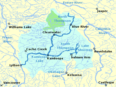
Thompson Country, also referred to as The Thompson and sometimes as the Thompson Valley and historically known as the Couteau Country or Couteau District, is a historic geographic region of the British Columbia Interior, Southern Interior of British Columbia, more or less defined by the basin of the Thompson River. This is a tributary of the Fraser River, Fraser; the major city in the area is Kamloops. Origin and usage The term originated among Scots and English in the days of the fur trade, who described Thompson Country as lying between New Caledonia (Canada), New Caledonia to the north and the Columbia District or Oregon Country to the south. Prior to their dominance, French traders referred to this as ''Couteau [knife] Country'' or ''Couteau District''. The Thompson nomenclature is still used today, although not as an official designation. It is often used combination forms, such as the Thompson-Okanagan or Thompson-Nicola Regional District. Weather forecasts and tourism inform ... [...More Info...] [...Related Items...] OR: [Wikipedia] [Google] [Baidu] |
Thompson Canyon
The Thompson River is the largest tributary of the Fraser River, flowing through the south-central portion of British Columbia, Canada. The Thompson River has two main branches, the South Thompson River and the North Thompson River. The river is home to several varieties of Pacific salmon and trout. The area's geological history was heavily influenced by glaciation, and the several large glacial lakes have filled the river valley over the last 12,000 years. Archaeological evidence shows human habitation in the watershed dating back at least 8,300 years. The Thompson was named by Fraser River explorer, Simon Fraser, in honour of his friend, Columbia Basin explorer David Thompson. Recreational use of the river includes whitewater rafting and angling. Geography South Thompson River The South Thompson originates at the outlet of Little Shuswap Lake at the town of Chase and flows approximately southwest through a wide valley to Kamloops where it joins the North Thompson. High ... [...More Info...] [...Related Items...] OR: [Wikipedia] [Google] [Baidu] |
Shuswap Country
The Shuswap Country, or simply the Shuswap (pronounced /ˈʃuːʃwɑːp/) and called Secwepemcúl̓ecw in Secwepemctsín, is a term used in the Canadian province of British Columbia to refer to the environs of Shuswap Lake. The upper reaches of the Shuswap basin, southeast of Shuswap Lake and northeast of the Okanagan, are generally considered to be part of Okanagan or of the Monashee Country rather than "the Shuswap". Roughly defined, the Shuswap Country begins on its west at the town of Chase, British Columbia, Chase, located on Little Shuswap Lake, west of which is the South Thompson area of the Thompson Country, and includes Adams Lake to the northwest of Shuswap Lake as well as communities in the Eagle River (Shuswap), Eagle River area as far as Craigellachie, British Columbia, Craigellachie and/or Three Valley Gap, which is at the summit of Eagle Pass (British Columbia), Eagle Pass, beyond which eastwards is the Columbia Country. Settlements and towns *Chase, British Co ... [...More Info...] [...Related Items...] OR: [Wikipedia] [Google] [Baidu] |
Adams Lake
Adams Lake is a deep, cold-water lake in south-central British Columbia, which separates the Thompson Country, Thompson and Shuswap Country, Shuswap regions and the Thompson–Nicola Regional District, Thompson–Nicola and Columbia–Shuswap Regional District, Columbia–Shuswap regional districts. The upper reaches lie in the northern Monashee Mountains, while the lower end penetrates the Shuswap Highland. The southern end is by road about northeast of Kamloops. Name origin On Archibald MacDonald's 1827 map, the river is called "Choo-chooach". On S. Black's 1835 map, the lake is unnamed. First Nations in Canada, First Nations Chief Sel-howt-kin, who lived on the lakeshore, became a Roman Catholic. When John Nobili, Father Nobli baptized him, he received the name Adam. Chief Adam (sometimes spelled Atahm) was a prominent Secwepemc chief in the mid-nineteenth century. By most accounts, the lake is named after him. Adam died in the 1862 Pacific Northwest smallpox epidemic, which ... [...More Info...] [...Related Items...] OR: [Wikipedia] [Google] [Baidu] |
Shuswap Highland
The Shuswap Highland is a plateau-like hilly area of in British Columbia, Canada Canada is a country in North America. Its Provinces and territories of Canada, ten provinces and three territories extend from the Atlantic Ocean to the Pacific Ocean and northward into the Arctic Ocean, making it the world's List of coun .... It spans the upland area between the Bonaparte and Thompson Plateaus from the area of Mahood Lake, at the southeast corner of the Cariboo Plateau, southeast towards the lower Shuswap River east of Vernon in the Okanagan. The highland is not a unified range, but a combination of small uplands broken up by the valleys of the Clearwater, North Thompson and Adams Rivers and also by the lowlands in the southwest flanking Shuswap Lake. In that area of the valley are the towns of Falkland, Westwold, and Monte Creek along Highway 97. This area also includes the Spa Hills, and the other isolated pockets of hills and mini-plateaus between the Tho ... [...More Info...] [...Related Items...] OR: [Wikipedia] [Google] [Baidu] |
Kamloops Lake
Kamloops Lake in British Columbia, Canada is situated on the Thompson River just west of Kamloops. The lake is 1.6 km wide, 29 km long, and up to 152 m deep. In prehistoric time, the lake was much longer, perhaps 20x, with adjacent silt cliffs defining ancient lake bottoms 100 meters higher than present water levels. At the outlet near Savona, a large tumbled rock, gravel moraine indicates the toe of a glacier once melted away here. The community of Savona, British Columbia, Savona is located at the west end of the lake, near the Thompson River outlet. The city of Kamloops is located a few miles east of the head of the lake, at the confluence of the North Thompson River, North and South Thompson Rivers. The name, Kamloops, derives from a local Indigenous word, Tk’emlúps, meaning a meeting of waters. The lake is bounded on all sides by steep hillsides, with level areas found only near creek deltas and around the inlet. On these hills, fresh, green grass feeds h ... [...More Info...] [...Related Items...] OR: [Wikipedia] [Google] [Baidu] |
Savona, British Columbia
Savona ( ) is an unincorporated community in the Thompson Country region of south central British Columbia. The place is on the western end and south shore of Kamloops Lake, adjacent to the outlet into the Thompson River. On British Columbia Highway 1, BC Highway 1, the locality is by road about east of Cache Creek, British Columbia, Cache Creek and west of Kamloops. The surrounding countryside is semi-arid grasslands and hills, which support cattle ranching. First Nations For thousands of years, First Nations in Canada, First Nations used trails and waterways to travel between hunting, fishing and trading areas. Prior to the 1860s, French was probably more common in parts of the interior than English. Consequently, Boute du Lac (meaning foot of the lake) Indians was the name initially assigned to this indigenous group. Since the Hudson's Bay Brigade Trail crossed the Thompson at Kamloops, these people would have experienced limited exposure to the French-speaking fur trade era. ... [...More Info...] [...Related Items...] OR: [Wikipedia] [Google] [Baidu] |


