|
Palk Strait
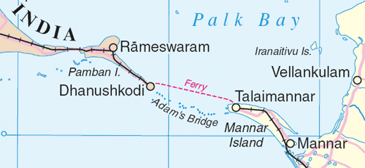
Palk Strait is a strait between the Indian state of Tamil Nadu and Northern Province of Sri Lanka. It connects the Palk Bay in the Bay of Bengal in the north with the Gulf of Mannar in the Laccadive sea in the south. It stretches for about and is wide. It is named after Robert Palk, who was a governor of Madras (1755–1763) during the Company Raj period. Several rivers including the Vaigai flow into the strait. The strait consists of many islands and is interspersed with a chain of low islands and reef shoals that are collectively called Ram Setu or Adam's bridge. The shallow waters and reefs make it difficult for large ships to pass through, although fishing boats and small craft navigate the waters. Dredging the sea to make it deeper for navigation and plans for a bridge over the waters have been proposed. Geography The Palk strait extends between Pamban island in the south eastern tip of the Indian state of Tamil Nadu and Thalaimannar in the Northern Provi ... [...More Info...] [...Related Items...] OR: [Wikipedia] [Google] [Baidu] |
Palk Bay
Palk Bay is a semi-enclosed shallow water body between the southeast coast of India and Sri Lanka, with a water depth maximum of 13 m. Palk Bay is located between 8° 50′ and 10° North latitudes and 78° 50′ and 80° 30′ East longitudes. The width of the bay ranges from 57 to 107 km and the length is around 150 km. It is one of the major sinks for sediments along with the Gulf of Mannar. Sediments discharged by rivers and transported by the surf currents as littoral drift settle in this sink. Few scientists have tried to understand the wave characteristics within the Palk Bay. In the southern regions close to Dhanushkodi, wind seas dominate. The north-eastern region of Palk Bay is exposed to the Bay of Bengal through the shallow Palk Strait allowing swells to enter. To the south, Adam's Bridge separates Palk Bay from the Gulf of Mannar. Despite being a very shallow channel, wave effects are transmitted to a small extent through the Adam's Bridge passag ... [...More Info...] [...Related Items...] OR: [Wikipedia] [Google] [Baidu] |
Vaigai River
The Vaigai is a river in the Tamil Nadu state of southern India; it passes through the towns of Theni, Madurai, Manamadurai, Paramakudi and Ramanathapuram. It originates in Varusanadu Hills, the Periyar Plateau of the Western Ghats range, and flows northeast through the Kambam Valley, which lies between the Palani Hills to the north and the Varushanad Hills to the south. The Vattaparai Falls are located on this river. As it rounds the eastern corner of the Varushanad Hills, the river turns southeast, running through the region of Pandya Nadu. Madurai, the largest city in the Pandya Nadu region and its ancient capital, lies on the Vaigai. The river empties into the Palk Bay near Alagankulam, close to Pamban Bridge in Ramanathapuram District. The Vaigai is long, with a drainage basin large. This river flows through 5 districts namely Theni, Dindigul, Madurai, Sivagangai and Ramanathapuram and this river Serves as a Lifeline for 6 districts namely Theni, Dindigul, Ma ... [...More Info...] [...Related Items...] OR: [Wikipedia] [Google] [Baidu] |
Ramayana
The ''Ramayana'' (; ), also known as ''Valmiki Ramayana'', as traditionally attributed to Valmiki, is a smriti text (also described as a Sanskrit literature, Sanskrit Indian epic poetry, epic) from ancient India, one of the two important epics of Hinduism known as the ''Itihasas'', the other being the ''Mahabharata''. The epic narrates the life of Rama, the seventh ''avatar'' of the Hindu deity Vishnu, who is a prince of Ayodhya (Ramayana), Ayodhya in the kingdom of Kosala. The epic follows Exile of Lord Rama, his fourteen-year exile to the forest urged by his father King Dasharatha, on the request of Rama's stepmother Kaikeyi; his travels across the forests in the Indian subcontinent with his wife Sita and brother Lakshmana; the kidnapping of Sita by Ravana, the king of Lanka, that resulted in bloodbath; and Rama's eventual return to Ayodhya (Ramayana), Ayodhya along with Sita to be crowned as a king amidst jubilation and celebration. Scholarly estimates for the earliest stage ... [...More Info...] [...Related Items...] OR: [Wikipedia] [Google] [Baidu] |
Indian Epic
Indian epic poetry is the epic poetry written in the Indian subcontinent, traditionally called ''Kavya'' (or ''Kāvya''; Sanskrit: काव्य, IAST: ''kāvyá''). The ''Ramayana'' and the ''Mahabharata'', which were originally composed in Sanskrit and later translated into many other Indian languages, and the Five Great Epics of Tamil literature and Sangam literature are some of the oldest surviving epic poems ever written. List of longest epics Hindi epics In modern Hindi literature, '' Kamayani'' by Jaishankar Prasad has attained the status of an epic. The narrative of Kamayani is based on a popular mythological story, first mentioned in Satapatha Brahmana. It is a story of the great flood and the central characters of the epic poem are Manu (a male) and Shraddha (a female). Manu is representative of the human psyche and Shradha represents love. Another female character is Ida, who represents rationality. Some critics surmise that the three lead characters of ... [...More Info...] [...Related Items...] OR: [Wikipedia] [Google] [Baidu] |
Hindu Mythology
Hindu mythology refers to the collection of myths associated with Hinduism, derived from various Hindu texts and traditions. These myths are found in sacred texts such as the Vedas, the Itihasas (the ''Mahabharata'' and the ''Ramayana''), and the Puranas. They also appear in regional and ethnolinguistic texts, including the Bengali ''Mangal Kavya'' and the Tamil '' Periya Puranam'' and ''Divya Prabandham''. Additionally, Hindu myths are also found in widely translated fables like the ''Panchatantra'' and the '' Hitopadesha'', as well as in Southeast Asian texts influenced by Hindu traditions. Meaning of "myth" Myth is a genre of folklore or theology consisting primarily of narratives that play a fundamental role in a society, such as foundational tales or origin myths. For folklorists, historians, philosophers or theologians this is very different from the use of "myth" simply indicating that something is not true. Instead, the truth value of a myth is not a def ... [...More Info...] [...Related Items...] OR: [Wikipedia] [Google] [Baidu] |
Thalaimannar
Talaimannar (; ) is a settlement in Sri Lanka located on the northwestern coast of Mannar Island. Transport Sri Lanka's northern railway line was destroyed, disrupted or neglected during the 30-year Sri Lankan civil war, which ended in May 2009. The Mannar railway line, rebuilt by an Indian company, was reopened by Indian Prime Minister Narendra Modi in 2015. The pier is served by a station of the Sri Lanka Railways with railway terminus at Talaimannar which connects Talaimannar to rail network in Sri Lanka via Medawachchiya. The town can be reached by a road from Mannar which links the island to the rest of highway network in Sri Lanka through a causeway, the A 14 road, carried by Mannar Bridge. Development Being a windy location, Talaimannar is a kitesurf and kiteboard destination. The government proposed a wind farm but was opposed by the local community as the area is a bird sanctuary. See also * Kachchatheevu * Palk Strait bridge *Railway stations in Sri Lanka *Tr ... [...More Info...] [...Related Items...] OR: [Wikipedia] [Google] [Baidu] |
Pamban Island
Pamban Island (, ''pāmpaṉ tīvu''), also known as Rameswaram Island, is an island located between peninsular India and Sri Lanka. It forms part of the Rameswaram taluk in the Ramanathapuram district of the Indian state of Tamil Nadu. It is the largest island in Tamil Nadu by area and the principal town in the island is the pilgrimage centre of Rameswaram. Location and size Pamban Island is situated between 9°11' N and 9°19' N latitude and 79°12' E to 79°23' E longitudes. The chain formed by Pamban Island, the shoals of Adam's Bridge, and Mannar Island of Sri Lanka separate Palk Bay and the Palk Strait in the northeast from the Gulf of Mannar in the southwest. Pamban Island extends for around 30 km in width from the township of Pamban in the west to the remains of Dhanushkodi towards the south-east. The length of the island varies from 2 km at the Dhanushkodi promontory to 7 km near Rameswaram. The area of the island is around 67 km2. Demographics Pam ... [...More Info...] [...Related Items...] OR: [Wikipedia] [Google] [Baidu] |
Tamil Nadu Topo Deutsch Mit Gebirgen
Tamil may refer to: People, culture and language * Tamils, an ethno-linguistic group native to India, Sri Lanka, and some other parts of Asia **Sri Lankan Tamils, Tamil people native to Sri Lanka ** Myanmar or Burmese Tamils, Tamil people of Indian origin settled in Burma/Myanmar primarily during the British period **Tamil Malaysians, Tamil people of Indian origin settled to Malaysia ** Singapore Tamils, Tamil people of Indian origin settled in Singapore **Tamil diaspora, descendants of Tamil immigrants living outside of India and Sri Lanka * Tamil language, the native language of the Tamils * Tamiloid languages, Dravidian languages related to Tamil, spoken in India * Tamil script, the writing system of the Tamil language **Tamil (Unicode block), a block of Tamil characters in Unicode * Tamil dialects, referencing geographical variations in speech * Tamil culture, culture of the Tamil people * Tamil cuisine, cuisine of the Tamil people * Tamil cinema (other) **Tamil cinem ... [...More Info...] [...Related Items...] OR: [Wikipedia] [Google] [Baidu] |
Dredging
Dredging is the excavation of material from a water environment. Possible reasons for dredging include improving existing water features; reshaping land and water features to alter drainage, navigability, and commercial use; constructing dams, dikes, and other controls for streams and shorelines; and recovering valuable mineral deposits or marine life having commercial value. In all but a few situations the excavation is undertaken by a specialist floating plant, known as a dredger. Usually the main objectives of dredging is to recover material of value, or to create a greater depth of water. Dredging systems can either be shore-based, brought to a location based on barges, or built into purpose-built vessels. Dredging can have environmental impacts: it can disturb marine sediments, creating dredge plumes which can lead to both short- and long-term water pollution, damage or destroy seabed ecosystems, and release legacy human-sourced toxins captured in the sediment. ... [...More Info...] [...Related Items...] OR: [Wikipedia] [Google] [Baidu] |
Adam's Bridge
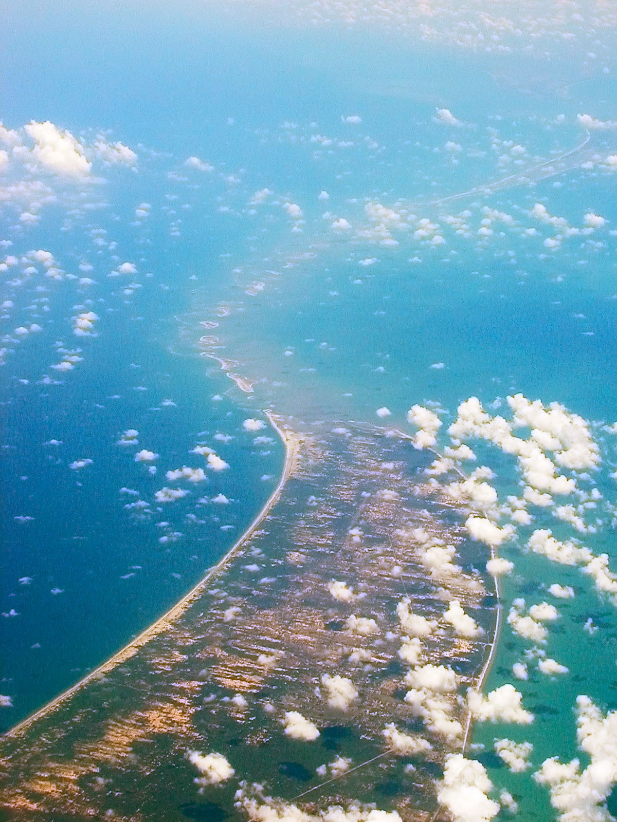
Adam's Bridge, also known as Rama's Bridge or ''Rama Setu'', is a chain of natural limestone shoals between Pamban Island, also known as Rameswaram Island, off the southeastern coast of Tamil Nadu, India, and Mannar Island, off the northwestern coast of Sri Lanka. Geological evidence suggests that the bridge was formerly a land connection between India and Sri Lanka. The feature is long and separates the Gulf of Mannar (southwest) from the Palk Strait (northeast). Some regions of the bridge are dry, and the sea in the area rarely exceeds in depth, making it quite difficult for boats to pass over it. Etymology Ibn Khordadbeh's '' Kitāb al-Masālik wa-l-Mamālik'' () refers to the structure as ''Set Bandhai'' (lit. Bridge of the Sea). The name Adam's Bridge appeared probably around the time of Al-Biruni (). This appears to have been premised on the Islamic belief that Adam's Peak — where the biblical Adam fell to earth — is located in Sri Lanka, and that Adam cross ... [...More Info...] [...Related Items...] OR: [Wikipedia] [Google] [Baidu] |
Ram Setu
Adam's Bridge, also known as Rama's Bridge or ''Rama Setu'', is a chain of natural limestone shoals between Pamban Island, also known as Rameswaram Island, off the southeastern coast of Tamil Nadu, India, and Mannar Island, off the northwestern coast of Sri Lanka. Geological evidence suggests that the bridge was formerly a land connection between India and Sri Lanka. The feature is long and separates the Gulf of Mannar (southwest) from the Palk Strait (northeast). Some regions of the bridge are dry, and the sea in the area rarely exceeds in depth, making it quite difficult for boats to pass over it. Etymology Ibn Khordadbeh's '' Kitāb al-Masālik wa-l-Mamālik'' () refers to the structure as ''Set Bandhai'' (lit. Bridge of the Sea). The name Adam's Bridge appeared probably around the time of Al-Biruni (). This appears to have been premised on the Islamic belief that Adam's Peak — where the biblical Adam fell to earth — is located in Sri Lanka, and that Adam crossed ov ... [...More Info...] [...Related Items...] OR: [Wikipedia] [Google] [Baidu] |


