|
Mesocco
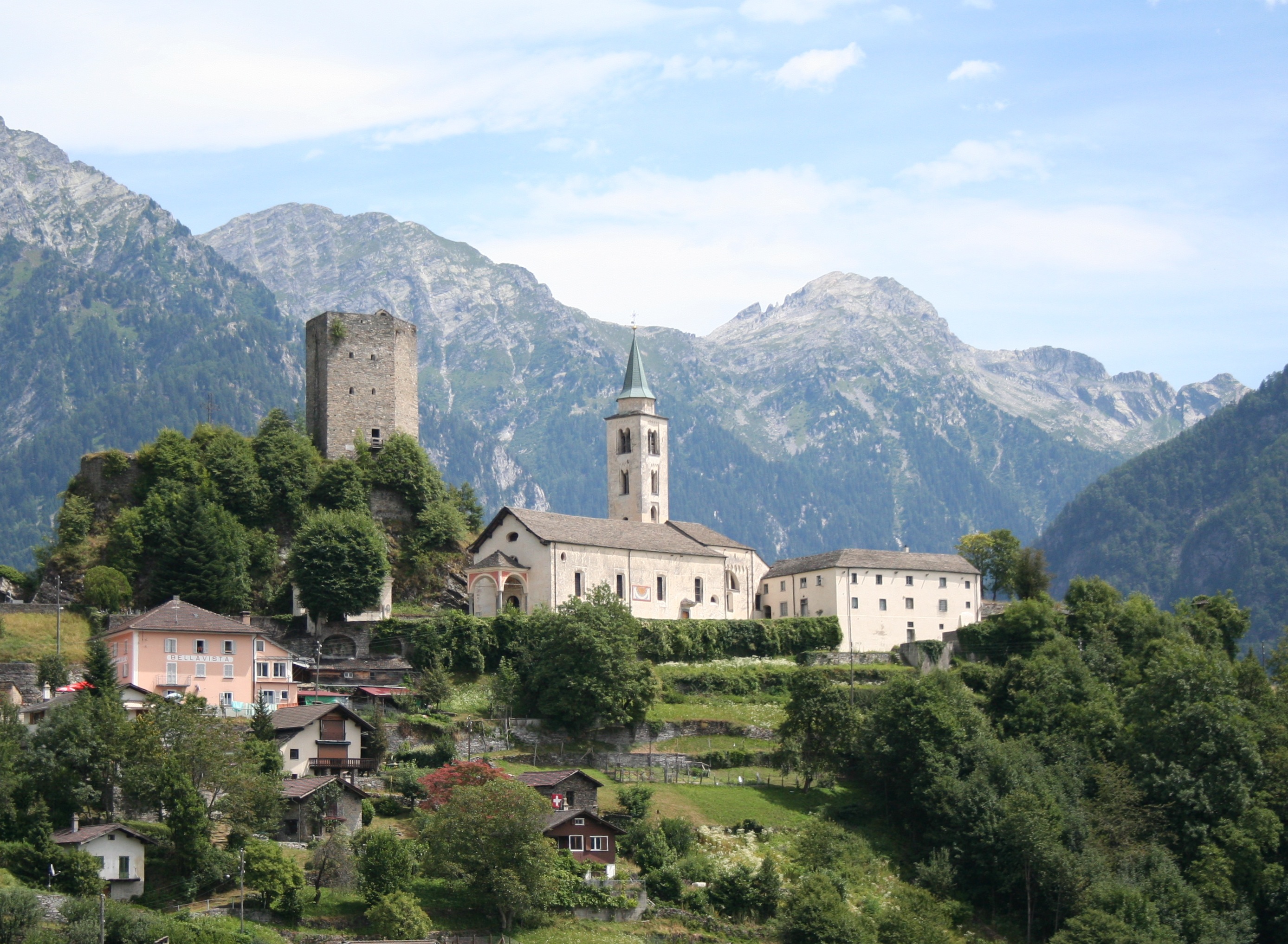
Mesocco () is a municipality in the Moesa Region in the Swiss canton of Graubünden. History The first human settlement in the area dates back to the Mesolithic era. Stone tools dating to about 6000 BC have been found in the Silex section of the municipality. At the same site, Neolithic fire pits and ceramics (5000 BC) were also discovered. The first permanent settlements in the area date to the Bronze Age (about 1400-1200 BC) and the pre-Roman Iron Age. A notable necropolis from the early Iron Age (600-500 BC) and traces of a Roman settlement were discovered on Gorda hill near the village. Additionally, an Early Middle Ages grave (6th century AD) was also discovered on the same hill. The castle was built in the 12th century and is first mentioned in 1219. The village of Mesocco is first mentioned in 1203 as ''Mesoco''. In 1383 it was mentioned as ''Misogg''. In 1480 Mesocco and Soazza willingly joined the Gray League. Between 1907 and 1978, Mesocco was linked to Bellinzona a ... [...More Info...] [...Related Items...] OR: [Wikipedia] [Google] [Baidu] |
Bellinzona–Mesocco Railway
The Bellinzona–Mesocco railway (; BM) was a Switzerland, Swiss metre gauge railway that linked the towns of Bellinzona, in the canton of Ticino, and Mesocco, in the canton of Graubünden. The line was built by the ''Società Anonima della Ferrovia Elettrica Bellinzona-Mesocco'' and later became part of the Rhaetian Railway. Before complete closure, the section of the line between Castione-Arbedo, and Cama, Switzerland, Cama was operated by the ''Società Esercizio Ferroviario Turistico'' (SEFT) as a tourist railway known as the ''Ferrovia Mesolcinese''. Project and construction The Gotthard railway opened in 1882, providing a transport link to the communities of the valley of the Ticino (river), Ticino River. In order to provide a link to the communities of the Val Mesolcina, a concession for the Bellinzona–Mesocco railway a committee was formed in 1891, which led to a concession being granted in 1899. The tributaries of the Moesa (river), Moesa river carry large quantities ... [...More Info...] [...Related Items...] OR: [Wikipedia] [Google] [Baidu] |
Moesa Region
The Moesa Region is one of the eleven Districts of Switzerland, administrative districts in the Cantons of Switzerland, Canton of the Grisons (or in German: Graubünden) in Switzerland. It had an area of and a population of (as of ).. It was created on 1 January 2017 as part of a reorganization of the Canton. The region borders with the Viamala Region to the north, with Italy to the east (Lombardy: Province of Sondrio and Province of Como, of Como) and with the Ticino, Canton of Ticino (districts of Bellinzona to the southwest, Riviera District, Riviera and Blenio) to the west. Politics Administrative division The Moesa region is divided into 12 municipalities: Demography The Moesa region has about 8500 inhabitants, mostly Italian-speaking, and is part of Italian-speaking Graubünden and Italian-speaking Switzerland. It is linked economically to the Ticino, Canton of Ticino; linguistically, however, a Lombard Alpine dialect is spoken that is heavily influenced ... [...More Info...] [...Related Items...] OR: [Wikipedia] [Google] [Baidu] |
Misox
The ''Valle Mesolcina'', also known as the ''Val Mesolcina'' or ''Misox'' (German), is an alpine valley of the Grisons, Switzerland, stretching from the San Bernardino Pass to Grono where it joins the Calanca Valley. It is the valley formed by the river Moesa. Like the Val Bregaglia or the Val Poschiavo, the Valle Mesolcina is a valley lying south of the main ridge of the Alps. Although politically the Valle Mesolcina belongs to the Grisons, its population is predominantly Italian-speaking and culturally oriented towards the Ticino. The valley includes the Mesocco and Roveredo of the Moesa district, including: * Mesocco * Soazza * Lostallo * Verdabbio * Cama * Leggia * Grono * Roveredo * San Vittore Religion The majority of the population adheres to Roman Catholicism, but there is a significant Protestant presence which is part of a Reformed community. located in Grono Grono may refer to: Places * Grono, Switzerland, municipality in Graubünden * Mount Grono ... [...More Info...] [...Related Items...] OR: [Wikipedia] [Google] [Baidu] |
San Bernardino, Switzerland
San Bernardino is a mountainous village in the canton of Grisons in Switzerland. It is the southern entry point to the San Bernardino tunnel, which complemented the road over the San Bernardino Pass in 1967, opening a new all-year-round road to crossing the Alps. The village is part of the municipality of Mesocco. The language spoken is Italian, one of the three official languages in the canton of Graubünden. The church dates from around 1450, only years before the ''Viamala'' gorge bridge was opened for traffic, multiplying traffic across the pass. Traffic The old ''Mulattiera'' is still visible and in good condition, this was the path for horses before the construction of a road in 1770 by the adjacent municipalities. In 1812 the state (or canton) of Graubünden built a new road that is actually the one still in use for local traffic and across the pass, whereas the tunnel traffic uses a newly built road that avoids serpentines to allow a fluent traffic. The walls were ... [...More Info...] [...Related Items...] OR: [Wikipedia] [Google] [Baidu] |
Bellinzona
Bellinzona ( , ; ; is a municipality, a List of towns in Switzerland, historic Swiss town, and the capital of the canton of Ticino in Switzerland. The town is famous for its Three Castles of Bellinzona, three castles (Castelgrande, Montebello, Sasso Corbaro) that have been UNESCO World Heritage Sites since 2000. The town lies east of the river Ticino (river), Ticino, at the foot of the Swiss Alps, Alps. It stretches along the river valley, surrounded by the southern ranges of the Lepontine Alps to the east and west, and by the Lugano Prealps to the south. Name and coat of arms The toponym is first attested in 590 in Latin as ''Belitio'' or ''Bilitio'' (in the accusative, ''Bilitionem''), by Gregory of Tours. The name is Lepontic in origin, possibly from ''belitio'' ("juniper") or ''belitione'' ("juniper bushes"). During the medieval period, the name is found as ''Berinzona'' (721, 762, 803, 1002), ''Birrinzona'' (1004), ''Birizona'' (1168), ''Beliciona'' (901, 977) and ''Belin ... [...More Info...] [...Related Items...] OR: [Wikipedia] [Google] [Baidu] |
Malvaglia
Malvaglia is a former municipality in the district of Blenio in the canton of Ticino in Switzerland. Since 15 March 2011, it is part of the municipality Serravalle. The reservoir Bacino di Val Malvaglia is located above the village of Malvaglia. History Malvaglia is first mentioned in 1205 as ''de Malvallia''. In German it used to be known as ''Manglia''. Malvaglia's development and history is closely tied to the development and history of the Blenio valley. In the settlement of Rongier, an ancient town on the Lukmanier road, a Roman coin hoard was found. The settlement is also home to the ''Casa Baggio''. ''Casa Baggio'' was built in the 16th century and expanded in the 17th. It was probably the ruling seat of the bailiff. The building is now listed as a historic building. Above the village is also the remains of ''Casa dei pagani'', a cave castle from the 11th-13th Centuries. The original, parish church was dedicated to St. Benedict and first mentioned in 1207. The c ... [...More Info...] [...Related Items...] OR: [Wikipedia] [Google] [Baidu] |
Nufenen
Nufenen (Italian: ''Novena'', Romansh: ''Nueinas'') is a former municipality in the Viamala Region in the Swiss canton of Graubünden. On 1 January 2019 the former municipalities of Hinterrhein, Nufenen and Splügen merged to form the new municipality of Rheinwald. History Nufenen was first mentioned in 1343 as ''Ovena''. In 1633 it was mentioned as ''Nufena''. In Romansh it was known as ''Nueinas'' and it used to be known as ''Novena'' in Italian. Geography Nufenen has an area, , of . Of this area, 54.9% is used for agricultural purposes, while 14.8% is forested. Of the rest of the land, 0.9% is settled (buildings or roads) and the remainder (29.5%) is non-productive (rivers, glaciers or mountains). Before 2017, the municipality was located in the Rheinwald sub-district, of the Hinterrhein district, after 2017 it was part of the Viamala Region. [...More Info...] [...Related Items...] OR: [Wikipedia] [Google] [Baidu] |
Rossa, Switzerland
Rossa is a municipality in the Moesa Region in the canton of Graubünden in Switzerland. Its official language is Italian. History Rossa is first mentioned in 1694. Geography Rossa has an area, , of . Of this area, 9.1% is used for agricultural purposes, while 40.8% is forested. Of the rest of the land, 0.4% is settled (buildings or roads) and the remainder (49.7%) is non-productive (rivers, glaciers or mountains). Before 2017, the municipality was located in the Calanca sub-district of the Moesa district, after 2017 it was part of the Moesa Region. accessed 16 February 2017 It is the highest municipality of Val Calanca ... [...More Info...] [...Related Items...] OR: [Wikipedia] [Google] [Baidu] |
San Giacomo Filippo
San Giacomo Filippo () is a (municipality) in the Province of Sondrio in the Italian region of Lombardy, located about north of Milan and about northwest of Sondrio, on the border with Switzerland. As of 31 December 2004, it had a population of 453 and an area of .All demographics and other statistics: Italian statistical institute Istat. The municipality of San Giacomo Filippo contains the ''frazioni'' (subdivisions, mainly villages and hamlets) San Bernardo ai Monti, Olmo, Sommarovina, Sant'Antonio di Albareda, Dalò, Uggia, Gallivaggio, Lirone, Cimaganda, Vho. San Giacomo Filippo borders the following municipalities: Campodolcino, Chiavenna, Menarola, Mese, Mesocco (Switzerland), Piuro, Soazza Soazza is a municipalities of Switzerland, municipality in the Moesa Region in the Switzerland, Swiss Cantons of Switzerland, canton of Graubünden. History Soazza is first mentioned in 1203 as ''Soaza''. Geography Soazza has an area, , of . ... (Switzerland). Demographi ... [...More Info...] [...Related Items...] OR: [Wikipedia] [Google] [Baidu] |
Soazza
Soazza is a municipalities of Switzerland, municipality in the Moesa Region in the Switzerland, Swiss Cantons of Switzerland, canton of Graubünden. History Soazza is first mentioned in 1203 as ''Soaza''. Geography Soazza has an area, , of . Of this area, 7.2% is used for agricultural purposes, while 53.7% is forested. Of the rest of the land, 1.5% is settled (buildings or roads) and the remainder (37.7%) is non-productive (rivers, glaciers or mountains). Demographics Soazza has a population (as of ) of . , 11.9% of the population was made up of foreign nationals. Over the last 10 years the population has decreased at a rate of -6.9%. Most of the population () speaks Italian (91.9%), with German being second most common ( 3.3%) and Serbo-Croatian being third ( 2.2%).Swiss Federal Statistical Office [...More Info...] [...Related Items...] OR: [Wikipedia] [Google] [Baidu] |
Madesimo
Madesimo (, called Isolato until 1983) is a ''comune'' (municipality) in the Province of Sondrio in the Italian region Lombardy The Lombardy Region (; ) is an administrative regions of Italy, region of Italy that covers ; it is located in northern Italy and has a population of about 10 million people, constituting more than one-sixth of Italy's population. Lombardy is ..., located about north of Milan and about northwest of Sondrio, on the border with Switzerland. Madesimo borders the following municipalities: Campodolcino, Ferrera (Switzerland), Medels im Rheinwald (Switzerland), Mesocco (Switzerland), Piuro, Splügen, Switzerland, Splügen (Switzerland), Sufers (Switzerland). Madesimo is a popular place for winter sports and summer holidays, and offers a variety of slopes and hills for both skiing and snowboarding. It features over 30 slopes which range from beginners to expert level. Among the slopes present in Madesimo is the Canalone, an off-the-track slope consider ... [...More Info...] [...Related Items...] OR: [Wikipedia] [Google] [Baidu] |
Hinterrhein, Switzerland
Hinterrhein () is a village and a former municipality in the Viamala Region in the Swiss canton of Graubünden. The village is located near the start of the river Hinterrhein/Rein Posteriur, one of the two initial tributaries of the Rhine. On 1 January 2019 the former municipalities of Hinterrhein, Nufenen and Splügen merged to form the new municipality of Rheinwald. History Hinterrhein is first mentioned in 1219 as ''de Reno''. Geography Hinterrhein has an area, , of . Of this area, 22.7% is used for agricultural purposes, while 7.6% is forested. Of the rest of the land, 1.2% is settled (buildings or roads) and the remainder (68.5%) is non-productive (rivers, glaciers or mountains). Before 2017, the municipality was located in the Rheinwald sub-district, of the Hinterrhine district, after 2017 it was part of the Viamala Region. It is a ''haufendorf'' (an irregular, unplanned and quite closely packed village, built around a central square) located on the northern portal of ... [...More Info...] [...Related Items...] OR: [Wikipedia] [Google] [Baidu] |


