|
Mačva
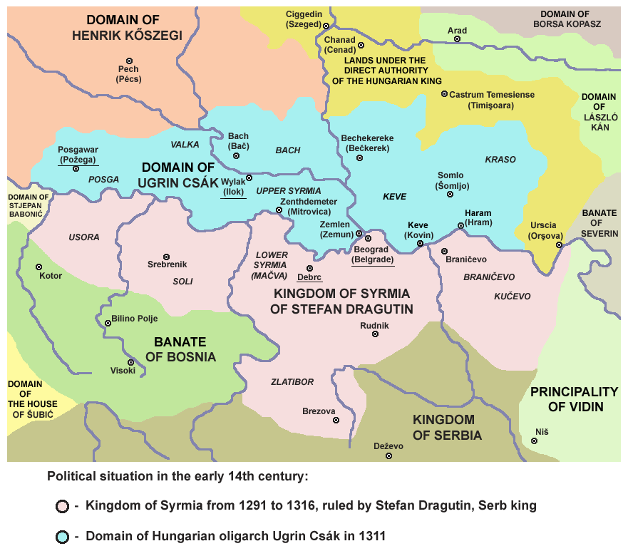
Mačva ( sr-Cyrl, Мачва, ; hu, Macsó) is a geographical and historical region in the northwest of Central Serbia, on a fertile plain between the Sava and Drina rivers. The chief town is Šabac. The modern Mačva District of Serbia is named after the region, although the region of Mačva includes only the northern part of this district. A small northern part of Mačva region is in the Autonomous Province of Vojvodina, in the Syrmia District. Name The region is named after a town of Mačva, which existed in the Medieval Ages near the river Sava. In the past, the region was also known as ''Lower Srem'', while the neighbouring region on the northern bank of the river Sava (present-day Srem) was known as ''Upper Srem''. In Serbian Cyrillic, the region is known as Мачва, in Serbian Latin, Bosnian and Croatian as ''Mačva'', in Hungarian as ''Macsó'' or ''Macsóság'', in Turkish as ''Maçva'', and in German as ''Matschva''. History Throughout history, the region of M ... [...More Info...] [...Related Items...] OR: [Wikipedia] [Google] [Baidu] |
Mačva District
The Mačva District ( sr, / , ) is one of eight administrative districts of Šumadija and Western Serbia. It expands in the western parts of Serbia, in the geographical regions of Mačva, Podrinje, Posavina, and Pocerina. According to the 2011 census results, it has a population of 298,931 inhabitants. The administrative center of the Mačva district is the city of Šabac. Cities and municipalities The district encompasses the cities of Šabac and Loznica and municipalities of: * Bogatić * Vladimirci * Koceljeva * Mali Zvornik * Krupanj * Ljubovija Demographics According to the last official census done in 2011, the Маčva District has 298,931 inhabitants. 29.14% of the population live in the urban areas. Ethnic groups Ethnic composition of the Mačva district: History and culture Famous monuments can be seen in the vicinity of Šabac, dedicated to events from the history of Serbian people: the Monument to Karađorđe and Serbian Heroes of the First Serbia ... [...More Info...] [...Related Items...] OR: [Wikipedia] [Google] [Baidu] |
Šabac
Šabac (Serbian Cyrillic: Шабац, ) is a city and the administrative centre of the Mačva District in western Serbia. The traditional centre of the fertile Mačva region, Šabac is located on the right banks of the river Sava. , the city proper has population of 53,919, while its administrative area comprises 118,347 inhabitants. Name The name ''Šabac'' was first mentioned in Ragusan documents dating to 1454. The origin of the city's name is uncertain; it is possible its name comes from the name of the city's main river, the Sava. The city is known by a variety of different names: ''Zaslon'' in medieval Serbian, ''Szabács'' in Hungarian, ''Böğürdelen'' in Turkish, and ''Schabatz'' in German. History Archaeological evidence attests to more permanent settlement in the area from the Neolithic. In the Middle Ages, a Slavic settlement named ''Zaslon'' existed at the current location of Šabac. The settlement was part of the Serbian Despotate until it fell to the Ottom ... [...More Info...] [...Related Items...] OR: [Wikipedia] [Google] [Baidu] |
Stefan Dragutin
Stefan Dragutin ( sr-cyr, Стефан Драгутин, hu, Dragutin István; 1244 – 12 March 1316) was King of Serbia from 1276 to 1282. From 1282, he ruled a separate kingdom which included northern Serbia, and (from 1284) the neighboring Hungarian banates (or border provinces), for which he was unofficially styled "King of Syrmia". He was the eldest son of King Stefan Uroš I of Serbia and Queen Helen. Dragutin married Catherine of Hungary, likely after his father concluded a peace treaty with her grandfather, Béla IV of Hungary, in 1268. By 1271, he received the title of "young king" in recognition of his right to succeed his father. He rebelled against his father, and with Hungarian assistance, forced him to abdicate in 1276. Dragutin abandoned Uroš I's centralizing policy and ceded large territories to his mother in appanage. After a riding accident, he abdicated in favor of his brother Milutin in 1282, but retained the northern region ... [...More Info...] [...Related Items...] OR: [Wikipedia] [Google] [Baidu] |
Serbia
Serbia (, ; Serbian: , , ), officially the Republic of Serbia (Serbian: , , ), is a landlocked country in Southeastern and Central Europe, situated at the crossroads of the Pannonian Basin and the Balkans. It shares land borders with Hungary to the north, Romania to the northeast, Bulgaria to the southeast, North Macedonia to the south, Croatia and Bosnia and Herzegovina to the west, and Montenegro to the southwest, and claims a border with Albania through the Political status of Kosovo, disputed territory of Kosovo. Serbia without Kosovo has about 6.7 million inhabitants, about 8.4 million if Kosvo is included. Its capital Belgrade is also the List of cities in Serbia, largest city. Continuously inhabited since the Paleolithic Age, the territory of modern-day Serbia faced Slavs#Migrations, Slavic migrations in the 6th century, establishing several regional Principality of Serbia (early medieval), states in the early Middle Ages at times recognised as tributaries to the B ... [...More Info...] [...Related Items...] OR: [Wikipedia] [Google] [Baidu] |
Central Serbia
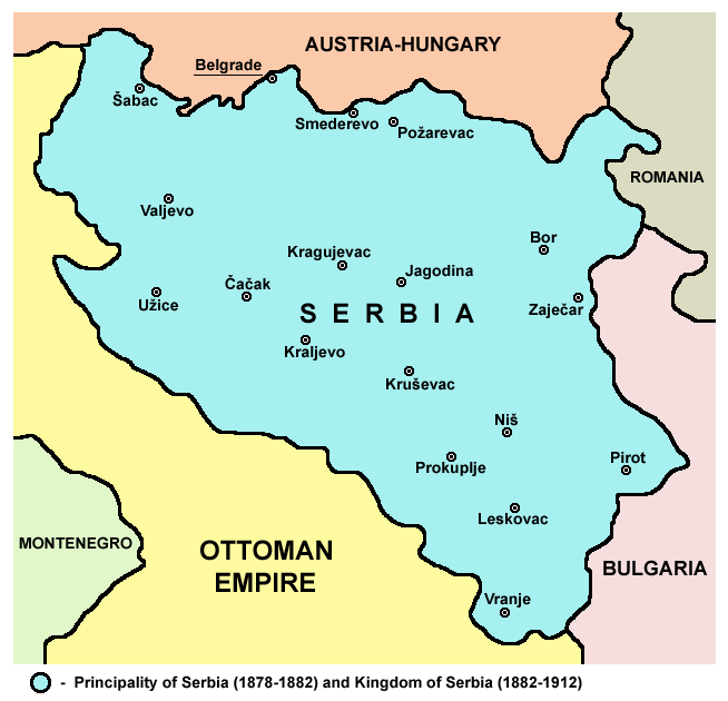
Central Serbia ( sr, централна Србија / centralna Srbija), also referred to as Serbia proper ( sr, link=no, ужа Србија / uža Srbija), is the region of Serbia lying outside the autonomous province of Vojvodina to the north and the disputed territory of Kosovo to the south. Central Serbia is a term of convenience, not an administrative division of Serbia as such, and does not have any form of separate administration. Broadly speaking, Central Serbia is the historical core of modern Serbia, which emerged from the Serbian Revolution (1804–17) and subsequent wars against the Ottoman Empire. In the following century, Serbia gradually expanded south, acquiring South Serbia, Kosovo, Sandžak and Vardar Macedonia, and in 1918 – following the unification and annexation of Montenegro and unification of Austro-Hungarian areas left of the Danube and Sava (Vojvodina) – it merged with other South Slavic territories into the Kingdom of Yugoslavia. The current bo ... [...More Info...] [...Related Items...] OR: [Wikipedia] [Google] [Baidu] |
Syrmia District
The Srem District ( sr, / , ) is one of seven administrative districts of the autonomous province of Vojvodina, Serbia. It lies in the geographical regions of Syrmia and Mačva. According to the 2011 census results, it has a population of 312,278 inhabitants. The administrative center is the city of Sremska Mitrovica. Name In Serbian, the district is known as ''Sremski okrug'' (), in Croatian as ''Srijemski okrug'', in Hungarian as ''Szerémségi Körzet'', in Slovak as ''Sriemskí okres'', in Rusyn as ''Srimski okruh'' (Сримски окрух), and in Romanian as ''Districtul Srem''. Administration The Srem District is one of seven districts (first-level administrative divisions) of Vojvodina (and 29 of Serbia). Districts are regional centers and do not have any form of self-government. The District includes the municipalities of: * Inđija * Irig * Pećinci * Ruma * Sremska Mitrovica * Stara Pazova * Šid History In Late antiquity, between the 3rd and 5th centuri ... [...More Info...] [...Related Items...] OR: [Wikipedia] [Google] [Baidu] |
Syrmia
Syrmia ( sh, Srem/Срем or sh, Srijem/Сријем, label=none) is a region of the southern Pannonian Plain, which lies between the Danube and Sava rivers. It is divided between Serbia and Croatia. Most of the region is flat, with the exception of the low Fruška gora mountain stretching along the Danube in its northern part. Etymology The word "Syrmia" is derived from the ancient city of Sirmium (now Sremska Mitrovica). Sirmium was a Celtic or Illyrian town founded in the third century BC. ''Srem'' ( sr-cyr, Срем) and ''Srijem'' are used to designate the region in Serbia and Croatia respectively. Other names for the region include: * Latin: ''Syrmia'' or ''Sirmium'' * Hungarian: ''Szerémség'', ''Szerém'', or ''Szerémország'' * German: ''Syrmien'' * Slovak: ''Sriem'' * Rusyn: Срим * Romanian: ''Sirmia'' History Prehistory Between 3000 BC and 2400 BC, Syrmia was at the centre of Indo-European Vučedol culture. Roman era Sirmium was c ... [...More Info...] [...Related Items...] OR: [Wikipedia] [Google] [Baidu] |
Serbian Despotate
The Serbian Despotate ( sr, / ) was a medieval Serbian state in the first half of the 15th century. Although the Battle of Kosovo in 1389 is generally considered the end of medieval Serbia, the Despotate, a successor of the Serbian Empire and Moravian Serbia, lasted for another 60 years, experiencing a cultural and political renaissance before it was conquered by the Ottomans in 1459. Before its conquest the Despotate was a tributary state of the neighbouring Byzantine Empire, Ottoman Empire, and Kingdom of Hungary, all of which considered it to be part of their sphere of influence. After 1459, political traditions of the Serbian Despotate continued to exist in exile, in the medieval Kingdom of Hungary, with several titular despots of Serbia, who were appointed by kings of Hungary. The last titular Despot of Serbia was Pavle Bakić, who fell in the Battle of Gorjani. History Origins After Prince Lazar Hrebeljanović was killed in the Battle of Kosovo on June 28, 13 ... [...More Info...] [...Related Items...] OR: [Wikipedia] [Google] [Baidu] |
Drina
The Drina ( sr-Cyrl, Дрина, ) is a long Balkans river, which forms a large portion of the border between Bosnia and Herzegovina and Serbia. It is the longest tributary of the Sava River and the longest karst river in the Dinaric Alps which belongs to the Danube river watershed. Its name is derived from the Roman name of the river ( la, Drinus) which in turn is derived from Greek (Ancient Greek: ). The Drina originates from the confluence of the rivers Tara and Piva, in the glen between the slopes of the Maglić, Hum and Pivska Planina mountains, in the area of Šćepan Polje (in Montenegro) and Hum (Bosnia and Herzegovina) villages. Hydrological characteristics The Drina is a very fast and cold alpine river, with a very high 175:346 meandering ratio, and relatively clean water, which has particularly intensive green coloration, a usual characteristic of most alpine rivers running through a karstic and flysch terrain made of limestone, underlying the area in wh ... [...More Info...] [...Related Items...] OR: [Wikipedia] [Google] [Baidu] |
Vojvodina
Vojvodina ( sr-Cyrl, Војводина}), officially the Autonomous Province of Vojvodina, is an autonomous province that occupies the northernmost part of Serbia. It lies within the Pannonian Basin, bordered to the south by the national capital Belgrade and the Sava and Danube Rivers. The administrative center, Novi Sad, is the second-largest city in Serbia. The historic regions of Banat, Bačka, and Syrmia overlap the province. Modern Vojvodina is multi-ethnic and multi-cultural, with some 26 ethnic groups and six official languages. About two million people, nearly 27% of Serbia's population, live in the province. Naming ''Vojvodina'' is also the Serbian word for voivodeship, a type of duchy overseen by a voivode. The Serbian Voivodeship, a precursor to modern Vojvodina, was an Austrian province from 1849 to 1860. Its official name is the Autonomous Province of Vojvodina. Its name in the province's six official languages is: * Croatian: ''Autonomna Pokrajina Vojvodina'' * ... [...More Info...] [...Related Items...] OR: [Wikipedia] [Google] [Baidu] |
Moravian Serbia
Moravian Serbia (), the Principality of Moravian Serbia ( sr, Кнежевина Моравска Србија, translit=Kneževina Moravska Srbija) or the Realm of Prince Lazar are the names used in historiography for the largest and most powerful Serbian principality to emerge from the ruins of the Serbian Empire (1371). Moravian Serbia was named after Morava, the main river of the region. The independent principality in the region of Morava was established in 1371, and attained its largest extent in 1379 through the military and political activities of its first ruler, prince Lazar Hrebeljanović. In 1402 it was raised to the Serbian Despotate, which would exist until 1459. History Lazar Hrebeljanović was born in around 1329 in the fortress of Prilepac, near the town of Novo Brdo in the region of Kosovo, Kingdom of Serbia. Lazar was a courtier at the court of Serbian Tsar Stefan Uroš Dušan, and at the court of Dušan's successor, Tsar Stefan Uroš V (r. 1356–1371). U ... [...More Info...] [...Related Items...] OR: [Wikipedia] [Google] [Baidu] |
Nikola Altomanović
Nikola Altomanović ( sr-Cyrl, Никола Алтомановић; died after 1395) was a 14th-century Serbian župan of the House of Vojinović. He ruled the areas from Rudnik, over Polimlje, Podrinje, east Herzegovina with Trebinje, reaching as far as Konavle and Dračevica, neighboring the Republic of Dubrovnik. He was defeated and blinded in Užice (fortress Užice) in 1373 by a coalition of his Serbian and Bosnian royals neighbors supported by the king of Hungary. Biography His father was Altoman Vojinović, a vojvod in Zeta. In 1363, Nikola's uncle Vojislav Vojinović was killed and Nikola used his uncle's death to gain a piece of his land. He allied himself with Lazar Hrebeljanović against King Vukašin Mrnjavčević and they managed to persuade Uroš to support them. However, after Lazar pulled out at the critical moment they were defeated at Kosovo in 1369. In 1373, a military alliance against Nikola was created, which included Bosnian Ban Tvrtko I Kotromanić, ... [...More Info...] [...Related Items...] OR: [Wikipedia] [Google] [Baidu] |


