|
Hochsauerlandkreis
Hochsauerlandkreis (, ) is a (district) in the east of North Rhine-Westphalia, Germany. Neighboring districts are Soest (district), Soest, Paderborn (district), Paderborn, Höxter (district), Höxter, Waldeck-Frankenberg, Siegen-Wittgenstein, Olpe (district), Olpe, Märkischer Kreis. The district is named “High Sauerland” because two of the highest mountains of the Sauerland, Sauerland mountainous landscape, Langenberg (Rothaar), Langenberg and Kahler Asten are in its territory. With 2,766 ft / 843 m (Langenberg) and 2,762 ft / 842 m (Kahler Asten) these are also the highest mountains of North Rhine-Westphalia. History The district was established in 1975 in the reorganization of the districts in North Rhine-Westphalia by merging the previous districts Arnsberg, Brilon and Meschede. Geography Geographically the district covers a big part of the Sauerland mountains, including the highest and third highest elevation – the Langenberg (Rothaar), Langenberg near Ol ... [...More Info...] [...Related Items...] OR: [Wikipedia] [Google] [Baidu] |
Schmallenberg
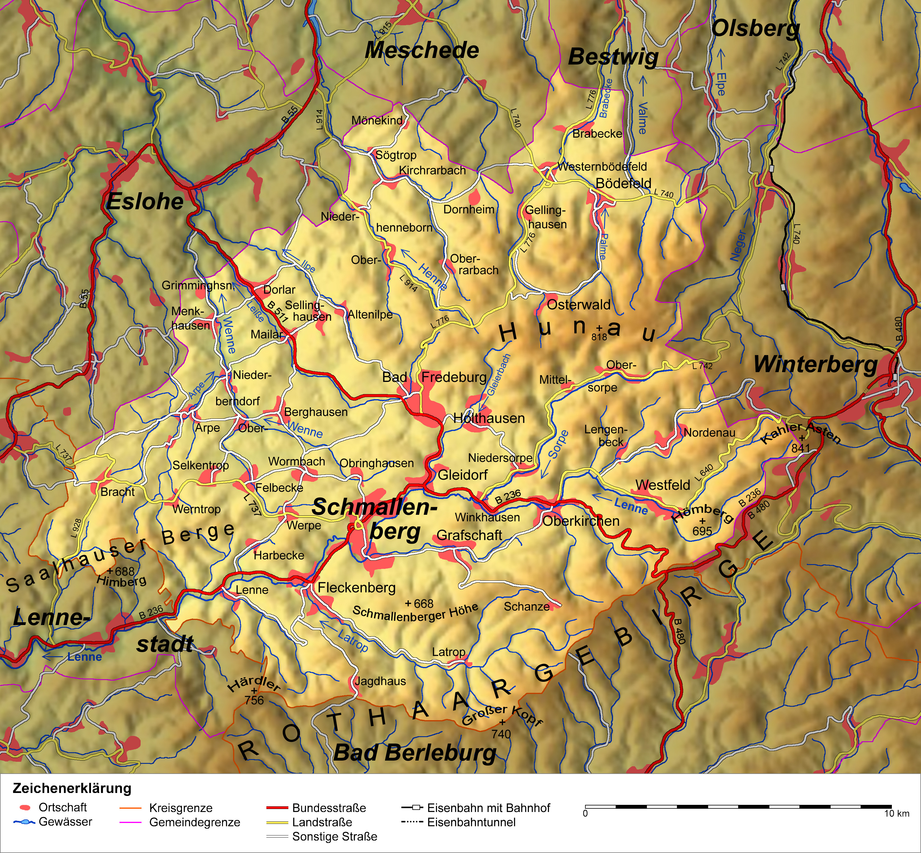
Schmallenberg (; ) is a town and a Luftkurort, climatic health resort in the Hochsauerlandkreis, High Sauerland District, Germany. By area, it is the :de:Liste der 100 flächengrößten Städte und Gemeinden Deutschlands, third biggest of all cities and towns of the States of Germany, state of North Rhine-Westphalia and the second biggest of the region of Westphalia. With small Schmallenberg central town and the rural Bad Fredeburg Sebastian Kneipp, Kneipp health resort the town has two urban settlements. Additionally, 82 villages and Hamlet (place)#Germany, hamlets belong to the town's territory. Also being called “the Schmallenberg Sauerland”, the Town of Schmallenberg is famous for its total of fiveStadt Schmallenberg: Kurort health resorts and nineSchmallenberger Sauerland: Golddörfer Schmallenberg und Esloh villages which have been awarded gold for their beauty in the nationwide “” contest. Geography Schmallenberg is located in the southeast of the Sauerland mounta ... [...More Info...] [...Related Items...] OR: [Wikipedia] [Google] [Baidu] |
Arnsberg
Arnsberg (; ) is a town in the Hochsauerland county, in the German state of North Rhine-Westphalia. It is the location of the Regierungsbezirk Arnsberg (region), Arnsberg administration and one of the three local administration offices of the Hochsauerlandkreis, Hochsauerlandkreis district. Geography Location Arnsberg is located in the north-east of the Sauerland in the Ruhr (river), Ruhr river valley. The river Ruhr sinuosity, meanders around the south of the old town of Arnsberg. The town is nearly completely encircled by forest, and the nature park ''Arnsberg Forest Nature Park, Arnsberger Wald'' lies to the north". Arnsberg is connected by Bundesautobahn 46, Federal Motorway 46 (Autobahn 46) Brilon in the east and (using the Bundesautobahn 445, Federal Motorway 445) Werl in the west. It is also connected by several railroad stations, which provide a connection to the major city Dortmund and the Ruhrgebiet. There is also a Flugplatz Arnsberg-Menden, regional airport, located ... [...More Info...] [...Related Items...] OR: [Wikipedia] [Google] [Baidu] |
Friedrich Merz
Joachim-Friedrich Martin Josef Merz (; ; born 11November 1955) is a German politician serving as Chancellor of Germany since 6 May 2025. He has also served as Leader of the Christian Democratic Union (CDU) since January 2022, leading the CDU/CSU (Union) parliamentary group as Leader of the Opposition (Germany), Leader of the Opposition in the Bundestag from February 2022 to May 2025. Merz was born in Brilon in the state of North Rhine-Westphalia in West Germany. He joined the Young Union in 1972. After finishing law school in 1985, Merz worked as a judge and corporate lawyer before entering full-time politics in 1989 when he was elected to the European Parliament. After serving one term he was elected to the Bundestag, where he established himself as the leading financial policy expert in the CDU. He was elected chairman of the CDU/CSU parliamentary group in 2000, the same year as Angela Merkel was elected chairwoman of the CDU, and at the time they were chief rivals for the lead ... [...More Info...] [...Related Items...] OR: [Wikipedia] [Google] [Baidu] |
Brilon
Brilon (; ) is a town in North Rhine-Westphalia, Germany, which belongs to the Hochsauerlandkreis. Geography Brilon is on the Brilon Heights, at an altitude of about 450m, and the upper reaches of the river Möhne. The town lies between the Arnsberg Forest nature reserve to the west and the Lake Diemel nature reserve and the Hoppecke to the south-east. Neighboring municipalities Division of the town After the local government reforms of 1975 Brilon consists of 17 districts: * Alme (1.273 inhabitants) * Altenbüren (1.453 inhabitants) * Bontkirchen (553 inhabitants) * Brilon Town (14.513 inhabitants) * Brilon-Wald (595 inhabitants) * Esshoff (80 inhabitants) * Gudenhagen/Petersborn (1.273 inhabitants) * Hoppecke (1.330 inhabitants) * Madfeld (1.395 inhabitants) * Messinghausen (898 inhabitants) * Nehden (503 inhabitants) * Radlinghausen (129 inhabitants) * Rixen (143 inhabitants) * Rösenbeck (858 inhabitants) * Scharfenberg (1.533 inhabitants) * Thülen (1.088 inhabitants ... [...More Info...] [...Related Items...] OR: [Wikipedia] [Google] [Baidu] |
Meschede
Meschede () is a town in the Hochsauerland district, in North Rhine-Westphalia, Germany. It is the capital of the district Hochsauerlandkreis. Education One of the five branches of South Westphalia University of Applied Sciences (also: Fachhochschule Südwestfalen (FH SWF)) is located here. Geography Meschede is situated in the Ruhr (river), Ruhr valley, near to the Hennesee, south of the nature-park Arnsberger Wald. Major towns in the vicinity of Meschede are Paderborn (51 km), Kassel (85 km), Siegen (57 km), Hagen, Dortmund (60 km) and Hamm, North Rhine-Westphalia, Hamm (49 km). Neighbouring municipalities * Arnsberg * Bestwig * Eslohe * Schmallenberg * Sundern * Warstein Division of the town After the local government reforms of 1975 Meschede consists of these districts and villages: History Meschede was founded as a settlement around a convent, the ''Walpurgis-Stift'' , in the 10th century. In 1572, it became a member of the Hanseatic Leagu ... [...More Info...] [...Related Items...] OR: [Wikipedia] [Google] [Baidu] |
Kahler Asten
The Kahler Asten () is an 841.9-metre-high mountain in the Rothaar Mountains, Rothaar range in the district of Hochsauerlandkreis, Hochsauerland, in the German state of North Rhine-Westphalia. It is a popular destination, receiving more than 500,000 visitors annually. Geography The ''Kahler Asten'' is located in the northwestern part of the Rothaargebirge in the Hochsauerland region, a little southwest of Winterberg between the villages of Altastenberg, Neuastenberg and Lenneplätze. Climate The climate of the Kahler Asten is characterized by high precipitation spread mostly evenly across the year, with a slight peak in winter, resulting in an often massive snowpack. In the Köppen climate classification, Köppen-Geiger climate classification system it is classified as Cfb (Oceanic climate, warm-summer oceanic), but bordering Dfb (Humid continental climate, warm-summer humid continental/hemiboreal) and also Cfc (Subpolar oceanic climate, subpolar oceanic), as only four month ... [...More Info...] [...Related Items...] OR: [Wikipedia] [Google] [Baidu] |
Eslohe
Eslohe is a municipality in the Hochsauerland district, in North Rhine-Westphalia, Germany. Geography Eslohe is situated approximately 25 km south-west of Meschede. Neighbouring municipalities * Finnentrop * Lennestadt * Meschede * Schmallenberg * Sundern Division of the town After the local government reforms of 1975 Eslohe consists of the following districts: Twin towns * Kisbér (Hungary) Notable people * Georg Milbradt (born 1945), politician (CDU) * Carola Matthiesen (1943-2015), German University Teacher References External links Official site Hochsauerlandkreis {{Hochsauerlandkreis-geo-stub ... [...More Info...] [...Related Items...] OR: [Wikipedia] [Google] [Baidu] |
Bestwig
Bestwig is a municipality in the Hochsauerland district, in North Rhine-Westphalia, Germany. Geography Bestwig is situated on the river Ruhr (river), Ruhr, approx. 10 km east of Meschede. It lies on the German Autobahn Bundesautobahn 46, A 46. Bestwig has a railway station, connecting the town through local trains to Dortmund Hauptbahnhof, Winterberg and Hagen Hauptbahnhof. Neighbouring municipalities * Olsberg, Germany, Olsberg * Schmallenberg * Meschede * Rüthen * Warstein Subdivisions Since 2009, the municipality is officially divided into six ''Ortschaften'', each containing one to five villages (''Ortsteile''). Economy Bestwig, surrounded by many acres of pine tree forests, is a centre of Christmas tree production. Tourism, however, is the most important source of income. The Sauerland forests are popular among hikers and, in winter, skiing is possible. Twin towns Bestwig has no official partnership with another town, but has close to ties to Niederorschel (Thur ... [...More Info...] [...Related Items...] OR: [Wikipedia] [Google] [Baidu] |
Sundern
Sundern () is a town in the Hochsauerland district, in North Rhine-Westphalia, Germany. The name Sundern is common in Westphalia, as it means "ground given away for private usage" in the Westphalian dialect. Geography Sundern is situated approximately south-west of Arnsberg. Around Sundern extends the nature park ''Homert'' which attracts tourists, many from the Netherlands. Winter tourism is also substantial, primarily in the municipality ''Wildewiese'' with its skiing area. The Sorpesee, an artificial lake, is used by watersportsmen, campers and fishermen. Neighbouring municipalities Division of the town Sundern consists of 16 ''Ortschaften'' (subdivisions): §3, Stadt Sundern * [...More Info...] [...Related Items...] OR: [Wikipedia] [Google] [Baidu] |
Medebach
Medebach () is a town in the Hochsauerland district, in North Rhine-Westphalia, Germany. Geography Medebach is situated approximately east of Winterberg, south-west of Korbach and north of Marburg. Neighbouring municipalities * Korbach * Lichtenfels * Willingen * Winterberg Division of the town Besides, the town center of Medebach, the municipality consists of the following districts, formerly independent villages: * ''with Roninghausen'' * ''with Wissinghausen'' * * * * * * * International relations Medebach is twinned with * Locminé (France) * Worbis (Germany) History The town was first mentioned in a document in 1144. It belonged to the Hanseatic League. Medebach and its district Oberschledorn entered the international news in September 2007 during the 2007 bomb plot in Germany, when three Islamic terrorists, two Germans and a Turk, were arrested there. They had received training in Pakistan and were about to build bombs from hydrogen peroxide ... [...More Info...] [...Related Items...] OR: [Wikipedia] [Google] [Baidu] |
Marsberg
Marsberg () is a town in the Hochsauerland district, in North Rhine-Westphalia, Germany. History Although its origins are obscure, Marsberg was a prospering town by the 13th century (it was even minting coins). It was a free city until 1807, when it was incorporated into the Kingdom of Westphalia, until 1813. After two years of independent government, it was added to Prussia in 1815. Geography It is situated on the river Diemel, approx. 20 km east of Brilon and 30 km south of Paderborn. Neighbouring municipalities * Bad Arolsen * Bad Wünnenberg * Brilon * Diemelsee * Diemelstadt * Lichtenau, Westphalia, Lichtenau * Warburg Town division Marsberg consists of the following 17 districts: * Beringhausen * Borntosten * Bredelar * Canstein * Erlinghausen * Essentho * Giershagen * Heddinghausen * Helminghausen * Leitmar * Meerhof * Niedermarsberg * Obermarsberg * Oesdorf * Padberg * Udorf * Westheim International relations Marsberg is town twinning, twinned with: ... [...More Info...] [...Related Items...] OR: [Wikipedia] [Google] [Baidu] |
Hallenberg
Hallenberg () is a town in the Hochsauerland district, in North Rhine-Westphalia, Germany. Geography Hallenberg is situated approximately 15 km southeast of Winterberg and 35 km north of Marburg (in Hesse). Neighbouring places * Allendorf (in Hesse) * Bad Berleburg * Bromskirchen (in Hesse) * Frankenberg, Hesse * Lichtenfels, Hesse * Medebach * Winterberg Division of the town Hallenberg consists of 4 districts: the town proper and 3 villages: * Hallenberg (2,660 inhabitants, 34.72 km²) * Braunshausen (350 inhabitants, 9.08 km²) * Hesborn (1,060 inhabitants, 14,18 km²) * Liesen (780 inhabitants, 7,38 km²) Personalities * Adolf Winkelmann (born 1946), film director and producer Currency From 1917 until the 1920s Hallenberg, like many German towns, produced its own currency, known as Notgeld (German language, German for 'emergency money' or 'necessity money') is money issued by an institution in a time of economic or political ... [...More Info...] [...Related Items...] OR: [Wikipedia] [Google] [Baidu] |


