|
History Of Shropshire
Shropshire was established during the division of Saxon Mercia into shires in the 10th century. It is first mentioned in 1006. After the Norman Conquest it experienced significant development, following the granting of the principal estates of the county to eminent Normans, such as Roger De Montgomery and his son Robert de Bellême. The Coalbrookdale area of the county is designated "the birthplace of the Industrial Revolution", due to significant technological developments that happened there. Etymology The origin of the name "Shropshire" is the Old English "Scrobbesbyrigscīr" (literally ''Shrewsburyshire''), taking its name from Richard Scrob (or Scrope), housecarl of King Edward the Confessor and the builder of Richard's Castle near what is now the town of Ludlow. However, the Normans who ruled England after 1066 found both "Scrobbesbyrig" and "Scrobbesbyrigscir" difficult to pronounce so they softened them to "Salopesberia" and "Salopescira". Salop is the abbreviation o ... [...More Info...] [...Related Items...] OR: [Wikipedia] [Google] [Baidu] |
Shropshire
Shropshire (; abbreviated SalopAlso used officially as the name of the county from 1974–1980. The demonym for inhabitants of the county "Salopian" derives from this name.) is a Ceremonial counties of England, ceremonial county in the West Midlands (region), West Midlands of England, on the England–Wales border, border with Wales. It is bordered by Cheshire to the north-east, Staffordshire to the east, Worcestershire to the south-east, Herefordshire to the south, and the Welsh principal areas of Powys and Wrexham County Borough, Wrexham to the west and north-west respectively. The largest settlement is Telford, while Shrewsbury is the county town. The county has an area of and a population of 498,073. Telford in the east and Shrewsbury in the centre are the largest towns. Shropshire is otherwise rural, and contains market towns such as Oswestry in the north-west, Market Drayton in the north-east, Bridgnorth in the south-east, and Ludlow in the south. For Local government i ... [...More Info...] [...Related Items...] OR: [Wikipedia] [Google] [Baidu] |
Shrewsbury
Shrewsbury ( , ) is a market town and civil parish in Shropshire (district), Shropshire, England. It is sited on the River Severn, northwest of Wolverhampton, west of Telford, southeast of Wrexham and north of Hereford. At the 2021 United Kingdom census, 2021 census, the parish had a population of 76,782. It is the county town of the ceremonial county of Shropshire. Shrewsbury has Anglo-Saxons, Anglo-Saxon roots and institutions whose foundations, dating from that time, represent a cultural continuity possibly going back as far as the 8th century. The centre has a largely undisturbed medieval street plan and over 660 Listed buildings in Shrewsbury, listed buildings, including several examples of timber framing from the 15th and 16th centuries. Shrewsbury Castle, a red sandstone fortification, and Shrewsbury Abbey, were founded in 1074 and 1083 respectively by the Normans, Norman Earl of Shrewsbury, Roger de Montgomery. The town is the birthplace of Charles Darwin. It has ... [...More Info...] [...Related Items...] OR: [Wikipedia] [Google] [Baidu] |
Enclave
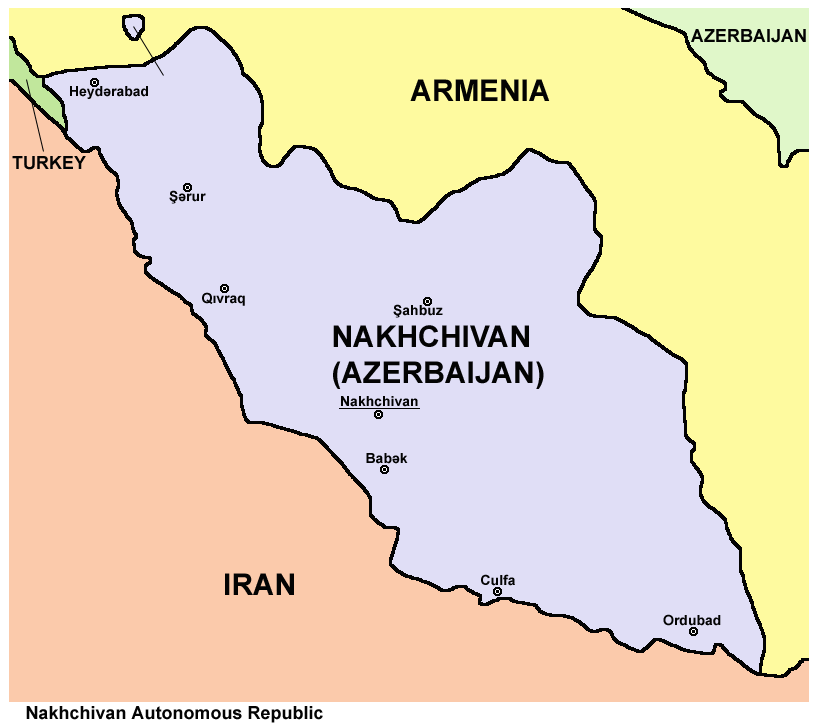
An enclave is a territory that is entirely surrounded by the territory of only one other state or entity. An enclave can be an independent territory or part of a larger one. Enclaves may also exist within territorial waters. ''Enclave'' is sometimes used improperly to denote a territory that is only partly surrounded by another state. Enclaves that are not part of a larger territory are not exclaves, for example Lesotho (enclaved by South Africa), and San Marino and Vatican City (both enclaved by Italy) are enclaved sovereign states. An exclave is a portion of a state or district geographically separated from the main part, by some surrounding alien territory. Many exclaves are also enclaves, but an exclave surrounded by the territory of more than one state is not an enclave. The Azerbaijani exclave of Nakhchivan is an example of an exclave that is not an enclave, as it borders Armenia, Iran, and Turkey. Semi-enclaves and semi-exclaves are areas that, except for possessing ... [...More Info...] [...Related Items...] OR: [Wikipedia] [Google] [Baidu] |
Exclave
An enclave is a territory that is entirely surrounded by the territory of only one other state or entity. An enclave can be an independent territory or part of a larger one. Enclaves may also exist within territorial waters. ''Enclave'' is sometimes used improperly to denote a territory that is only partly surrounded by another state. Enclaves that are not part of a larger territory are not exclaves, for example Lesotho (enclaved by South Africa), and San Marino and Vatican City (both enclaved by Italy) are enclaved sovereign states. An exclave is a portion of a state or district geographically separated from the main part, by some surrounding alien territory. Many exclaves are also enclaves, but an exclave surrounded by the territory of more than one state is not an enclave. The Azerbaijani exclave of Nakhchivan is an example of an exclave that is not an enclave, as it borders Armenia, Iran, and Turkey. Semi-enclaves and semi-exclaves are areas that, except for possessing ... [...More Info...] [...Related Items...] OR: [Wikipedia] [Google] [Baidu] |
Historic Counties Of England
The historic counties of England are areas that were established for administration by the Normans, in many cases based on earlier Heptarchy, kingdoms and shires created by the Angles (tribe), Angles, Saxons, Jutes, Celts and the Danes (tribe), Danes and Norsemen, Norse in the North. They are alternatively known as ''ancient counties'', ''traditional counties'', ''former counties'' or simply as ''counties''. In the centuries that followed their establishment, as well as their administrative function, the counties also helped define local culture and identity. This role continued even after the counties ceased to be used for administration after the creation of Administrative counties of England, administrative counties in 1889, which were themselves amended by further local government reforms in the years following. Unlike the partly self-governing Ancient borough, boroughs that covered urban areas, the counties of medieval England existed primarily as a means of enforcing cent ... [...More Info...] [...Related Items...] OR: [Wikipedia] [Google] [Baidu] |
Ceremonial Counties Of England
Ceremonial counties, formally known as ''counties for the purposes of the lieutenancies'', are areas of England to which lord-lieutenant, lord-lieutenants are appointed. A lord-lieutenant is the Monarchy of the United Kingdom, monarch's representative in an area. Shrieval counties have the same boundaries and serve a similar purpose, being the areas to which High sheriff#England, Wales, and Northern Ireland, high sheriffs are appointed. High sheriffs are the monarch's judicial representative in an area. The ceremonial counties are defined in the Lieutenancies Act 1997, and the shrieval counties in the Sheriffs Act 1887. Both are defined as groups of Local government in England, counties used for local government. History The historic counties of England were originally used as areas for administering justice and organising the militia, overseen by a High sheriff, sheriff. From Tudor period, Tudor times onwards a lord-lieutenant was appointed to oversee the militia, taki ... [...More Info...] [...Related Items...] OR: [Wikipedia] [Google] [Baidu] |
Montgomeryshire
Montgomeryshire ( ) was Historic counties of Wales, one of the thirteen counties of Wales that existed from 1536 until their abolishment in 1974. It was named after its county town, Montgomery, Powys, Montgomery, which in turn was named after one of William the Conqueror's main counsellors, Roger de Montgomerie, 1st Earl of Shrewsbury, Roger de Montgomerie, who was the 1st Earl of Shrewsbury. The area of what was Montgomeryshire, now constitutes the northern part of the Counties and county boroughs of Wales, county of Powys. The current area was 2,174 square km (839 square miles). The largest town was Newtown, Powys, Newtown, followed by Welshpool and Llanidloes. History The Treaty of Montgomery was signed on 29 September 1267, in the town of Montgomery, which had recently been established as an English incursion on the Welsh side of the border, to control a strategic border crossing. The surrounding region (on the Welsh side of the border) otherwise comprised the mediaeval ... [...More Info...] [...Related Items...] OR: [Wikipedia] [Google] [Baidu] |
Welsh Marches
The Welsh Marches () is an imprecisely defined area along the border between England and Wales in the United Kingdom. The precise meaning of the term has varied at different periods. The English term Welsh March (in Medieval Latin ''Marchia Walliae'') was originally used in the Middle Ages to denote the marches between England and the Principality of Wales, in which Marcher lords had specific rights, exercised to some extent independently of the king of England. In modern usage, "the Marches" is often used to describe those English counties which lie along the border with Wales, particularly Shropshire and Herefordshire, and sometimes adjoining areas of Wales. However, at one time the Marches included all of the historic counties of Cheshire, Shropshire, Herefordshire, Worcestershire and Gloucestershire. Etymology The term ''March'' is from the 13th-century Middle English ''marche'' ("border region, frontier"). The term was borrowed from Old French ''marche'' ("limit, bo ... [...More Info...] [...Related Items...] OR: [Wikipedia] [Google] [Baidu] |
Laws In Wales Act
The Laws in Wales Acts 1535 and 1542 () or the Acts of Union (), were acts of the Parliament of England under King Henry VIII of England, causing Wales to be incorporated into the realm of the Kingdom of England. The legal system of England and the norms of English administration including the use of the English language only were applied to a mainly Welsh-speaking Wales. This created a single state and legal jurisdiction, which is now called England and Wales. Before these acts, Wales had already been annexed by England in 1284 and was excluded from parliamentary representation. Wales was divided between the Principality of Wales and many feudal statelets called the marcher Lordships which were effectively unified under the laws. The English county system was also extended across all of Wales. Background After Henry VIII made himself the head of the Church of England in 1534, Wales was seen as a potential problem which included some ambitious men unhappy with ethnic dis ... [...More Info...] [...Related Items...] OR: [Wikipedia] [Google] [Baidu] |
Chirbury
Chirbury () is a village and former civil parish, now in the parish of Chirbury with Brompton, in the Shropshire district, in west Shropshire, England. It is situated in the Vale of Montgomery, close to the Wales–England border ( at its nearest), which is to its north, west and south. The A490 and B4386 routes cross at Chirbury. It is the largest settlement in the Chirbury with Brompton civil parish, which according to the 2001 census had a population of 914, with the resident population of Chirbury at 348. The population of the civil parish had increased to 971 at the 2011 census. History The placename was recorded in 915 as ''Ċyriċbyrig'' in the ''Anglo-Saxon Chronicle'', and as ''Ċireberie'' in the Domesday Book of 1086, and means "the fort with a church". Its Welsh name, ''Llanffynhonwen'', means "the church of the white well" or "...of the holy well". Some French linguists have theorised that the name of Chirbury shares a common etymology with the city of Cherbo ... [...More Info...] [...Related Items...] OR: [Wikipedia] [Google] [Baidu] |
Oswestry
Oswestry ( ; ) is a market town, civil parish and historic railway town in Shropshire, England, close to the England–Wales border, Welsh border. It is at the junction of the A5 road (Great Britain), A5, A483 road, A483 and A495 road, A495 roads. The town was the administrative headquarters of the Borough of Oswestry until that was abolished in 2009. Oswestry is the third-largest town in Shropshire, following Telford and Shrewsbury. At the 2021 Census, the population was 17,509. The town is from the Welsh border and has a mixed English and Welsh heritage. Oswestry is the largest settlement within the Oswestry Uplands, a designated Natural areas of England, natural area and national character area. Toponym The name ''Oswestry'' is first attested in 1191, as . This Middle English name transparently derives from the Old English personal name and the word ('tree'). Thus the name seems once to have meant 'tree of a man called Ōswald'.A. D. Mills, ''A Dictionary of English Pl ... [...More Info...] [...Related Items...] OR: [Wikipedia] [Google] [Baidu] |
Hundred (county Division)
A hundred is an administrative division that is geographically part of a larger region. It was formerly used in England, Wales, some parts of the United States, Denmark, Sweden, Finland, Norway, and in Cumberland County in the British Colony of New South Wales. It is still used in other places, including in Australia (in South Australia and the Northern Territory). Other terms for the hundred in English and other languages include '' wapentake'', ''herred'' (Danish and Bokmål Norwegian), ''herad'' ( Nynorsk Norwegian), ''härad'' or ''hundare'' (Swedish), ''Harde'' (German), ''hiird'' ( North Frisian), ''kihlakunta'' (Finnish), and '' cantref'' (Welsh). In Ireland, a similar subdivision of counties is referred to as a barony, and a hundred is a subdivision of a particularly large townland (most townlands are not divided into hundreds). Etymology The origin of the division of counties into hundreds is described by the ''Oxford English Dictionary'' (''OED'') as "exceedingly ... [...More Info...] [...Related Items...] OR: [Wikipedia] [Google] [Baidu] |


