|
Geography Of The Democratic Republic Of The Congo
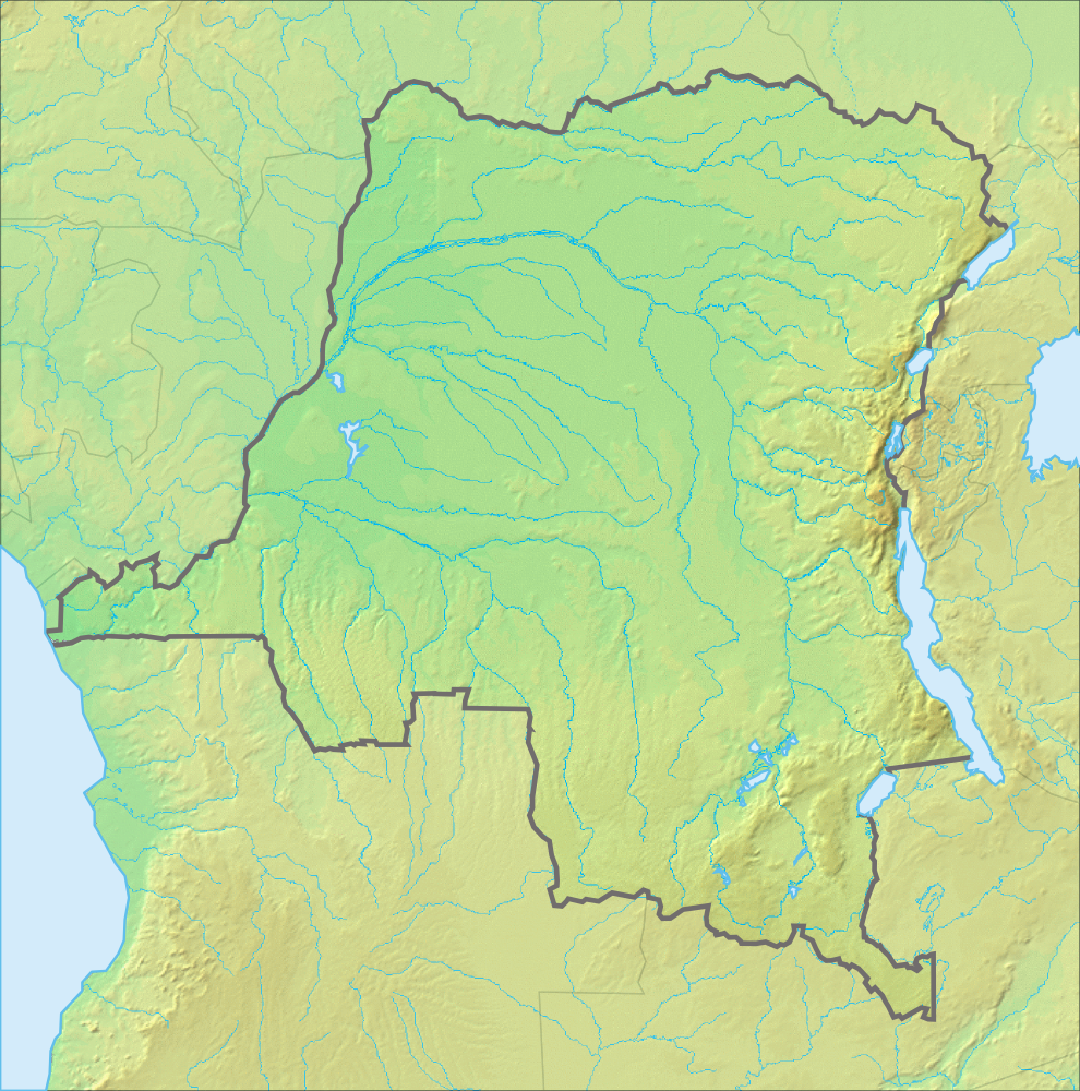
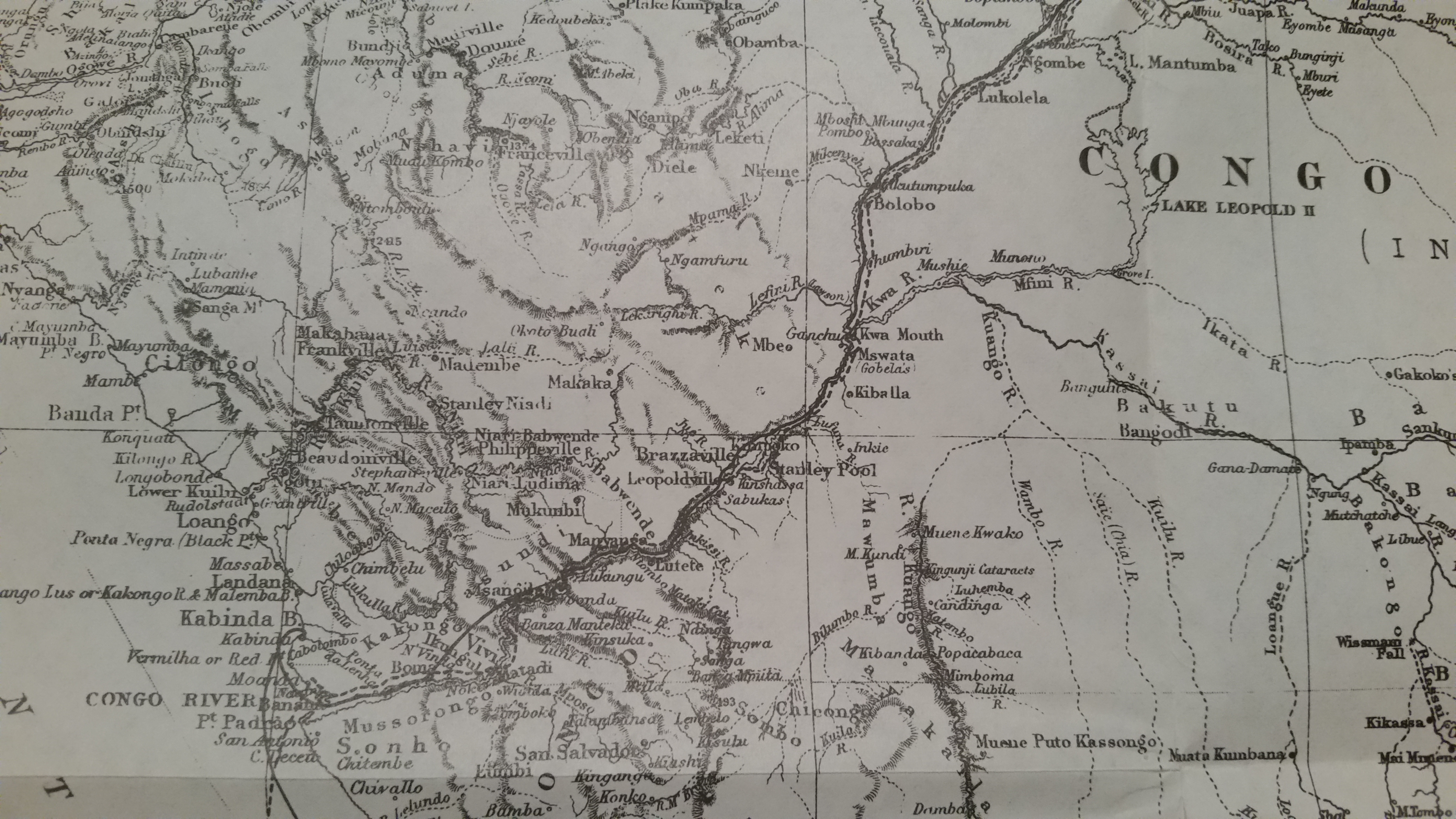
Geographic regions Several major geographic regions may be defined in terms of terrain and patterns of natural vegetation, namely the central Congo Basin, the uplands north and south of the basin, and the eastern highlands. The country's core region is the central Congo Basin. Having an average elevation of about , it measures roughly , constituting about a third of the DRC's territory. Much of the forest within the basin is swamp, and still more of it consists of a mixture of marshes and firm land. North and south of the basin lie higher plains and, occasionally, hills covered with varying mixtures of savanna grasses and woodlands. The southern uplands region, like the basin, constitutes about a third of the DRC's territory. The area slopes from south to north, starting at about near the Angolan border and falling to about near the basin. Vegetation cover in the southern uplands territory is more varied than that of the northern uplands. In some areas, woodland is dom ... [...More Info...] [...Related Items...] OR: [Wikipedia] [Google] [Baidu] |
Great Rift Valley
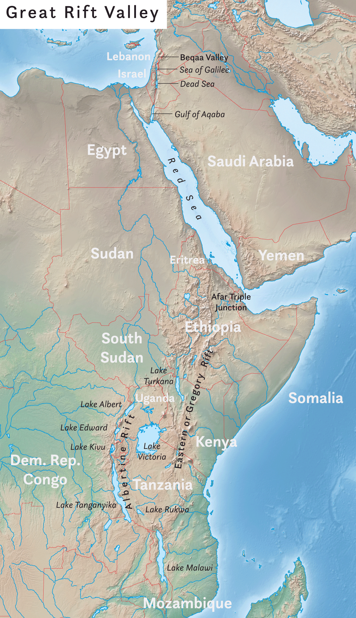
The Great Rift Valley () is a series of contiguous geographic depressions, approximately 6,000 or in total length, the definition varying between sources, that runs from the southern Turkish Hatay Province in Asia, through the Red Sea, to Mozambique in Southeast Africa. While the name remains in some usages, it is rarely used in geology where the term "Afro-Arabian Rift System" is preferred. This valley extends southward from Western Asia into the eastern part of Africa, where several deep, elongated lakes, called ribbon lakes, exist on the rift valley floor, Lake Malawi and Lake Tanganyika being two such examples. The region has a unique ecosystem and contains a number of Africa's wildlife parks. The term Great Rift Valley is most often used to refer to the valley of the East African Rift, the divergent plate boundary which extends from the Afar triple junction southward through eastern Africa, and is in the process of splitting the African plate into two new and sep ... [...More Info...] [...Related Items...] OR: [Wikipedia] [Google] [Baidu] |
Lake Albert (Africa)
Lake Albert, originally known as Lake Mwitanzige by the Banyoro, Nam Ovoyo Bonyo by the Alur, and temporarily as Lake Mobutu Sese Seko, is a lake located in Uganda and the Democratic Republic of the Congo. It is Africa's seventh-largest lake and the second biggest of Uganda's Great Lakes. Geography Lake Albert is located on the border between Uganda and the Democratic Republic of the Congo. It is the northernmost of the chain of lakes in the Albertine Rift, the western branch of the East African Rift. It is about long and across at its widest, with a maximum depth of , and a surface elevation of above sea level. Lake Albert is part of the complicated system of the upper Nile. Its main sources are the White Nile, ultimately coming from Lake Victoria to the southeast, and the Semliki River, which issues from Lake Edward to the southwest. The water of the Victoria Nile is much less saline than that of Lake Albert. The lake's outlet, at its northernmost tip, is the Alb ... [...More Info...] [...Related Items...] OR: [Wikipedia] [Google] [Baidu] |
Atlantic Ocean
The Atlantic Ocean is the second largest of the world's five borders of the oceans, oceanic divisions, with an area of about . It covers approximately 17% of Earth#Surface, Earth's surface and about 24% of its water surface area. During the Age of Discovery, it was known for separating the New World of the Americas (North America and South America) from the Old World of Afro-Eurasia (Africa, Asia, and Europe). Through its separation of Afro-Eurasia from the Americas, the Atlantic Ocean has played a central role in the development of human society, globalization, and the histories of many nations. While the Norse colonization of North America, Norse were the first known humans to cross the Atlantic, it was the expedition of Christopher Columbus in 1492 that proved to be the most consequential. Columbus's expedition ushered in an Age of Discovery, age of exploration and colonization of the Americas by European powers, most notably Portuguese Empire, Portugal, Spanish Empire, Sp ... [...More Info...] [...Related Items...] OR: [Wikipedia] [Google] [Baidu] |
Salient (geography)
A salient, panhandle, or bootheel is an elongated protrusion of a geopolitical entity, such as a subnational entity or a sovereign state. While similar to a peninsula in shape, a salient is most often not surrounded by water on three sides. Instead, it has a land border on at least two sides and extends from the larger geographical body of the administrative unit. In American English, the term panhandle is often used to describe a relatively long and narrow salient, such as the westernmost extensions of Florida Panhandle, Florida and Oklahoma Panhandle, Oklahoma, or the northernmost portion of Idaho Panhandle, Idaho. Another term is bootheel, used for the Missouri Bootheel and New Mexico Bootheel areas. Origin The term ''salient'' is derived from salient (military), military salients. The term "panhandle" derives from the analogous part of a cooking pan, and its use is generally confined to North America. The salient shape can be the result of arbitrarily drawn international ... [...More Info...] [...Related Items...] OR: [Wikipedia] [Google] [Baidu] |
Katanga Province
Katanga was one of the four large provinces created in the Belgian Congo in 1914. It was one of the eleven provinces of the Democratic Republic of the Congo between 1966 and 2015, when it was split into the Tanganyika Province, Tanganyika, Haut-Lomami, Lualaba Province, Lualaba, and Haut-Katanga provinces. Between 1971 and 1997 (during the rule of Mobutu Sese Seko when Congo was known as Zaire), its official name was Shaba Province. Katanga's area encompassed . Farming and ranching are carried out on the Katanga Plateau. The eastern part of the province is a rich mining region which supplies cobalt, copper, tin, radium, uranium, and diamonds. The region's former capital, Lubumbashi, is the second-largest city in the Congo. History Copper mining in Katanga dates back over 1,000 years, and mines in the region were producing standard-sized ingots of copper for international transport by the end of the 10th century CE. In the 1890s, the province was beleaguered from the south by ... [...More Info...] [...Related Items...] OR: [Wikipedia] [Google] [Baidu] |
Gallery Forest
A gallery forest is one formed as a corridor along rivers or wetlands, projecting into landscapes that are otherwise only sparsely treed such as savannas, grasslands, or deserts. The gallery forest maintains a more temperate microclimate above the river. Defined as long and narrow forest vegetation associated with rivers, gallery forests are structurally and floristically heterogeneous. The habitats of these forests differ from the surrounding landscapes because they are, for example, more nutrient-rich or moister and/or there is less chance of fires. The forests are sometimes only a few meters wide, because they depend on the water they lie along. Ecology characteristics The riparian zones in which they grow offer greater protection from fire which would kill tree seedlings. In addition, the alluvial soils of the gallery habitat are often of higher fertility and have better drainage than the soils of the surrounding landscape with a more reliable water supply at depth. As a ... [...More Info...] [...Related Items...] OR: [Wikipedia] [Google] [Baidu] |
Kasai River
The Kasai River (, ; called Cassai in Angola) is a left bank tributary of the Congo River, located in Central Africa. The river begins in central Angola and flows to the east until it reaches the border between Angola and the Democratic Republic of the Congo, where it turns north and serves as the border until it flows into the DRC. From Ilebo, between the confluences with Lulua river and Sankuru river, the Kasai river turns to a westerly direction. The lower stretch of the river, from the confluence with Fimi river until it joins the Congo at Kwamouth northeast of Kinshasa, is also known as the Kwa(h) River. The Kasai basin consists mainly of equatorial rainforest areas, which provide an agricultural land in a region noted for its infertile, sandy soil. It is a tributary of Congo river and diamonds are found in it. Around 60% of diamonds in Belgium go from Kasai river for cutting and shaping. Exploration Henry Morton Stanley reached the confluence on 9 March 1877, calli ... [...More Info...] [...Related Items...] OR: [Wikipedia] [Google] [Baidu] |
Angola
Angola, officially the Republic of Angola, is a country on the west-Central Africa, central coast of Southern Africa. It is the second-largest Portuguese-speaking world, Portuguese-speaking (Lusophone) country in both total area and List of countries and dependencies by population, population and is the List of African countries by area, seventh-largest country in Africa. It is bordered by Namibia to the south, the Democratic Republic of the Congo to the north, Zambia to the east, and the Atlantic Ocean to the west. Angola has an Enclave and exclave, exclave province, the province of Cabinda Province, Cabinda, that borders the Republic of the Congo and the Democratic Republic of the Congo. The capital and most populous city is Luanda. Angola has been inhabited since the Paleolithic, Paleolithic Age. After the Bantu expansion reached the region, states were formed by the 13th century and organised into confederations. The Kingdom of Kongo ascended to achieve hegemony among the ... [...More Info...] [...Related Items...] OR: [Wikipedia] [Google] [Baidu] |
Woodland
A woodland () is, in the broad sense, land covered with woody plants (trees and shrubs), or in a narrow sense, synonymous with wood (or in the U.S., the '' plurale tantum'' woods), a low-density forest forming open habitats with plenty of sunlight and limited shade (see differences between British, American and Australian English explained below). Some savannas may also be woodlands, such as ''savanna woodland'', where trees and shrubs form a light canopy. Woodlands may support an understory of shrubs and herbaceous plants including grasses. Woodland may form a transition to shrubland under drier conditions or during early stages of primary or secondary succession. Higher-density areas of trees with a largely closed canopy that provides extensive and nearly continuous shade are often referred to as forests. Extensive efforts by conservationist groups have been made to preserve woodlands from urbanization and agriculture. For example, the woodlands of Northwest Indiana ha ... [...More Info...] [...Related Items...] OR: [Wikipedia] [Google] [Baidu] |
Savanna
A savanna or savannah is a mixed woodland-grassland (i.e. grassy woodland) biome and ecosystem characterised by the trees being sufficiently widely spaced so that the canopy does not close. The open canopy allows sufficient light to reach the ground to support an unbroken herbaceous layer consisting primarily of grasses. Four savanna forms exist; ''savanna woodland'' where trees and shrubs form a light canopy, ''tree savanna'' with scattered trees and shrubs, ''shrub savanna'' with distributed shrubs, and ''grass savanna'' where trees and shrubs are mostly nonexistent.Smith, Jeremy M.B.. "savanna". Encyclopedia Britannica, 5 Sep. 2016, https://www.britannica.com/science/savanna/Environment. Accessed 17 September 2022. Savannas maintain an open canopy despite a high tree density. It is often believed that savannas feature widely spaced, scattered trees. However, in many savannas, tree densities are higher and trees are more regularly spaced than in forests.Manoel Cláudio da ... [...More Info...] [...Related Items...] OR: [Wikipedia] [Google] [Baidu] |
