|
Fraser Valley Regional District
The Fraser Valley Regional District (FVRD) is a regional district in British Columbia, Canada. Its headquarters are in the city of Chilliwack. The FVRD covers an area of 13,361.74 km2 (5,159 sq mi). It was created in 1995 by an amalgamation of the Fraser-Cheam Regional District and Central Fraser Valley Regional District and the portion of the Dewdney-Alouette Regional District from and including the District of Mission eastwards. The FVRD is the third most populous Regional District in British Columbia, incorporating roughly the eastern half of the Lower Mainland of southwestern BC, and is bordered by Whatcom County, Washington to the south, Metro Vancouver to the west, the Okanagan-Similkameen Regional District to the east, the Squamish-Lillooet Regional District to the northwest, and the Thompson-Nicola Regional District to the northeast. It also includes unincorporated areas north of the City of Pitt Meadows, which were part of the Dewdney-Alouet ... [...More Info...] [...Related Items...] OR: [Wikipedia] [Google] [Baidu] |
Hope, British Columbia
Hope is a district municipality at the confluence of the Fraser River, Fraser and Coquihalla River, Coquihalla rivers in the province of British Columbia, Canada. Hope is at the eastern end of both the Fraser Valley and the Lower Mainland region, and is at the southern end of the Fraser Canyon. To the east, over the North Cascades, Cascade Mountains, is the British Columbia Interior, Interior region, beginning with the Similkameen Country on the farther side of the Allison Pass in Manning Park. Located east of Vancouver, Hope is at the southern terminus of the British Columbia Highway 5#Coquihalla Highway, Coquihalla Highway and the western terminus of the Crowsnest Highway, locally known as the Hope-Princeton (Highways British Columbia Highway 5, 5 and British Columbia Highway 3, 3, respectively), where they merge with the Trans-Canada Highway (British Columbia Highway 1, Highway 1). Hope is at the eastern terminus of British Columbia Highway 7, Highway 7. As it lies at the eas ... [...More Info...] [...Related Items...] OR: [Wikipedia] [Google] [Baidu] |
Pitt Meadows, British Columbia
Pitt Meadows is a city within Metro Vancouver in southwestern British Columbia, Canada. Incorporated in 1914, it currently has a land area of with an estimate population of 19,498 as of 2024. The city received its name from the Pitt River and Pitt Lake. Pitt Meadows is one of the cities in British Columbia including Metro Vancouver Electoral Area A, Electoral Area A that comprises the Metro Vancouver Regional District. Pitt Meadows Is 110 Years old. Indigenous Peoples have resided in Pitt Meadows for approximately 1000 years. James McMillan explored the area in 1874. The Municipality of Maple Ridge, which included the Pitt Meadows area, was incorporated in 1874. In 1892, residents of the Pitt Meadows area petitioned for their removal from the District of Maple Ridge. In 1893, the first dyking district was organized; however, the Fraser River Flood of 1894 flooded many acres of land in Pitt Meadows. In 1914, Pitt Meadows was a small, agricultural community of less than 250 indiv ... [...More Info...] [...Related Items...] OR: [Wikipedia] [Google] [Baidu] |
Indigenous Peoples In Canada
Indigenous peoples in Canada (also known as Aboriginals) are the Indigenous peoples of the Americas, Indigenous peoples within the boundaries of Canada. They comprise the First Nations in Canada, First Nations, Inuit, and Métis#Métis people in Canada, Métis, representing roughly 5.0% of the total Population of Canada, Canadian population. There are over 600 recognized List of First Nations peoples in Canada, First Nations governments or Band government, bands with distinctive cultures, languages, art, and music. Old Crow Flats and Bluefish Caves are some of the earliest known sites of human habitation in Canada. The characteristics of Indigenous cultures in Canada prior to European colonization included permanent settlements, agriculture, civic and ceremonial architecture, complex Hierarchy, societal hierarchies, and Trade, trading networks. Métis nations of mixed ancestry originated in the mid-17th century when First Nations and Inuit people married Europeans, primarily the ... [...More Info...] [...Related Items...] OR: [Wikipedia] [Google] [Baidu] |
South Asian Canadians
South Asian Canadians are Canadians who were either born in or can trace their Ancestor, ancestry to South Asia or the Indian subcontinent, which includes the nations of India, Pakistan, Bangladesh, Nepal, Bhutan, Sri Lanka, and the Maldives. The term also includes immigrants from South Asian diaspora, South Asian communities in Asian Africans#Indians in Africa, East and South Africa, Guyana, Trinidad and Tobago, Fiji, Mauritius, and the rest of the world. The term South Asian Canadian is a subgroup of Asian Canadians, Asian Canadian and, according to Statistics Canada, can further be divided by nationality, such as Indo-Canadians, Indian Canadian, Pakistani Canadians, Pakistani Canadian, and Bangladeshi Canadians, Bangladeshi Canadian. () As of 2021, South Asians (7.1 percent) comprise the second largest Panethnicity, pan-ethnic group in Canada after European Canadians, Europeans (69.8 percent). According to the 2021 Canadian census, 2,571,400 Canadians had South Asi ... [...More Info...] [...Related Items...] OR: [Wikipedia] [Google] [Baidu] |
European Canadians
European Canadians are Canadians who can trace their Ancestor, ancestry to the continent of Europe. They form the largest Panethnicity, panethnic group within Canada. In the 2021 Canadian census, 19,062,115 people or 52.5% of the population self-identified ethnic origins from Europe. People may nominate more than one ethnic origin in the census. Terminology As with other Panethnicity, panethnic groups, Statistics Canada records ethnic ancestry by employing the term "European origins" under the ethnic origin population section in the census data, but does not specifically use the term "European Canadian". "Euro-Canadians" and "European Canadians" are terms primarily used by those opposed to immigration to Canada from the Third World, and their use has been criticized as conflating distinctions between very different European groups and nationalities. Those employing the terms can recognize that most Canadians of European descent do not see that as their collective identity and in ... [...More Info...] [...Related Items...] OR: [Wikipedia] [Google] [Baidu] |
Population
Population is a set of humans or other organisms in a given region or area. Governments conduct a census to quantify the resident population size within a given jurisdiction. The term is also applied to non-human animals, microorganisms, and plants, and has specific uses within such fields as ecology and genetics. Etymology The word ''population'' is derived from the Late Latin ''populatio'' (a people, a multitude), which itself is derived from the Latin word ''populus'' (a people). Use of the term Social sciences In sociology and population geography, population refers to a group of human beings with some predefined feature in common, such as location, Race (human categorization), race, ethnicity, nationality, or religion. Ecology In ecology, a population is a group of organisms of the same species which inhabit the same geographical area and are capable of Sexual reproduction, interbreeding. The area of a sexual population is the area where interbreeding is possi ... [...More Info...] [...Related Items...] OR: [Wikipedia] [Google] [Baidu] |
Panethnicity
Panethnicity is a political neologism used to group various ethnic groups together based on their related cultural origins; geographic, linguistic, religious, or "racial" (i.e. phenotypic) similarities are often used alone or in combination to draw panethnic boundaries. The term panethnic was used extensively during mid-20th century anti-colonial/national liberation movements. In the United States, Yen Le Espiritu popularized the term and coined the nominal term panethnicity in reference to Asian Americans, a racial category composed of disparate peoples having in common only their origin in the continent of Asia. It has since seen some use as a replacement of the term '' race''; for example, the aforementioned Asian Americans can be described as "a panethnicity" of various unrelated peoples of Asia, which are nevertheless perceived as a distinguishable group within the larger multiracial North American society. More recently the term has also come to be used in contexts outs ... [...More Info...] [...Related Items...] OR: [Wikipedia] [Google] [Baidu] |
Harrison Hot Springs, British Columbia
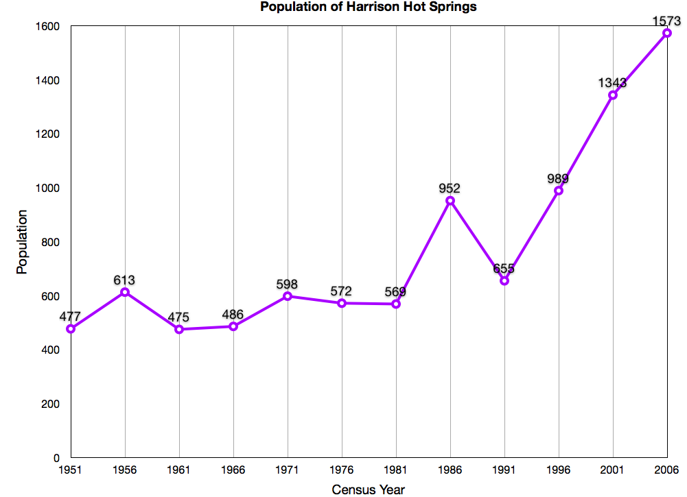
Harrison Hot Springs is a village located at the southern end of Harrison Lake in the Fraser Valley of British Columbia, Canada. It is a part of the Fraser Valley Regional District; its immediate neighbour is the District of Kent, which includes the town of Agassiz. As its name would suggest, it is a resort community known for its hot springs and has a population of just over 1,500 people. It is named after Benjamin Harrison, a former deputy governor of the Hudson's Bay Company. History The Village of Harrison Hot Springs began as a small resort community in 1886, when the opening of the Canadian Pacific Railway brought the lakeside springs within a short carriage ride of the transcontinental mainline. In its first promotion as a resort it was known as St. Alice's Well, although Europeans had discovered it decades earlier when a party of goldfield-bound travelers on Harrison Lake capsized into what they thought was their doom, only to discover the lake at that spot was not fr ... [...More Info...] [...Related Items...] OR: [Wikipedia] [Google] [Baidu] |
Kent, British Columbia
The District of Kent is a district municipality located east of Vancouver, British Columbia. Part of the Fraser Valley Regional District, Kent consists of several communities, the largest and most well-known being Agassiz—the only town in the municipality— Harrison Mills, Kilby, Mount Woodside, Kent Prairie, Sea Bird Island and Ruby Creek. Included within the municipality's boundaries are several separately-governed Indian reserves, including the Seabird Island First Nation's reserves on and around the island of the same name. Kent's only incorporated municipal neighbours are Chilliwack, to the south across the Fraser, and Harrison Hot Springs which is an enclave on the north side of the municipality at the south end of Harrison Lake. Chehalis, to the west across the Harrison River from Harrison Mills, is unincorporated and largely an Indian reserve community of the Chehalis First Nation of the Sts'Ailes people. Neighbourhoods Located north of Chilliwack and south ... [...More Info...] [...Related Items...] OR: [Wikipedia] [Google] [Baidu] |
Mission, British Columbia
Mission is a city in the Lower Mainland of the province of British Columbia, Canada. It was originally incorporated as a district municipality in 1892, growing to include additional villages and rural areas over the years, adding the original Town of Mission City, along an independent core of the region, in 1969. It is bordered by the city of Abbotsford, British Columbia, Abbotsford to the south and the city of Maple Ridge, British Columbia, Maple Ridge to the west. To the east are the unincorporated areas of Hatzic and Dewdney, British Columbia, Dewdney. It is situated on the north bank of the Fraser River, backing onto mountains and lakes overlooking the Fraser Valley, Central Fraser Valley southeast of Vancouver. Geography Unlike the other Fraser Valley municipalities, Mission is mostly forested upland with only small floodplains lining the shore of the Fraser River. Some benches of farmland rise in succession northwards above the core developed area of the city. Mission wa ... [...More Info...] [...Related Items...] OR: [Wikipedia] [Google] [Baidu] |
2021 Canadian Census
The 2021 Canadian census was a detailed enumeration of the Canada, Canadian population with a reference date of May 11, 2021. It follows the 2016 Canadian census, which recorded a population of 35,151,728. The overall response rate was 98%, which is slightly lower than the response rate for the 2016 census. It recorded a population of 36,991,981, a 5.2% increase from 2016. It will be succeeded by 2026 Canadian census, Canada's 2026 census. Planning Consultation on census program content was from September 11 to December 8, 2017. The census was conducted by Statistics Canada, and was contactless as a result of the COVID-19 pandemic in Canada. The agency had considered delaying the census until 2022. About 900 supervisors and 31,000 field enumerators were hired to conduct the door-to-door survey of individuals and households who had not completed the census questionnaire by late May or early June. Canvassing agents wore masks and maintained a physical distance to comply with COV ... [...More Info...] [...Related Items...] OR: [Wikipedia] [Google] [Baidu] |


