|
Earthquakes In Indonesia
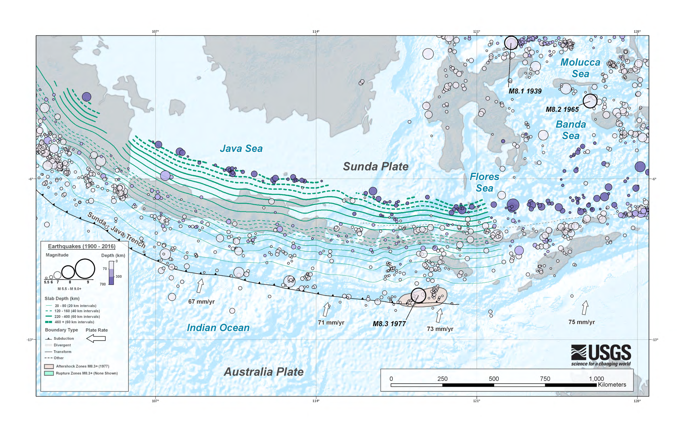
__NOTOC__ This is an incomplete list of more recent recorded major earthquakes that have occurred within the boundaries of Indonesia. The determinants of the activity are indicated by the geology of the region, and the volcanic activity. Large numbers of earthquakes of smaller magnitude occur very regularly due to the meeting of major tectonic plates in the region. Based on the records of the United States Geological Survey, USGS, Indonesia has had more than 150 earthquakes with magnitude > 7 in the period 1901–2019. Earthquakes 2000–present 1900–1999 1629–1899 Gallery File:COLLECTIE TROPENMUSEUM Een door een aardbeving verwoeste Chinese woonwijk TMnr 10003972.jpg, Earthquake damage in Ambon Island, Ambon, 1898 File:COLLECTIE TROPENMUSEUM Twee Balinezen poseren voor ingestorte huizen op Bali na de aardbeving van 1917 TMnr 10004142.jpg, 1917 Bali earthquake File:COLLECTIE TROPENMUSEUM Verwoeste gebouwen langs de spoorweg van Padang Pandjang na de aardbeving van ... [...More Info...] [...Related Items...] OR: [Wikipedia] [Google] [Baidu] |
Indonesia
Indonesia, officially the Republic of Indonesia, is a country in Southeast Asia and Oceania, between the Indian Ocean, Indian and Pacific Ocean, Pacific oceans. Comprising over List of islands of Indonesia, 17,000 islands, including Sumatra, Java, Sulawesi, and parts of Borneo and New Guinea, Indonesia is the world's largest archipelagic state and the List of countries and dependencies by area, 14th-largest country by area, at . With over 280 million people, Indonesia is the world's List of countries and dependencies by population, fourth-most-populous country and the most populous Islam by country, Muslim-majority country. Java, the world's List of islands by population, most populous island, is home to more than half of the country's population. Indonesia operates as a Presidential system, presidential republic with an elected People's Consultative Assembly, legislature and consists of Provinces of Indonesia, 38 provinces, nine of which have Autonomous administrative divisi ... [...More Info...] [...Related Items...] OR: [Wikipedia] [Google] [Baidu] |
Bali
Bali (English:; Balinese language, Balinese: ) is a Provinces of Indonesia, province of Indonesia and the westernmost of the Lesser Sunda Islands. East of Java and west of Lombok, the province includes the island of Bali and a few smaller offshore islands, notably Nusa Penida, Nusa Lembongan, and Nusa Ceningan to the southeast. The provincial capital, Denpasar, is the List of Indonesian cities by population, most populous city in the Lesser Sunda Islands and the second-largest, after Makassar, in Eastern Indonesia. Denpasar metropolitan area is the extended metropolitan area around Denpasar. The upland town of Ubud in Greater Denpasar is considered Bali's cultural centre. The province is Indonesia's main tourist destination, with a significant rise in Tourism in Bali, tourism since the 1980s, and becoming an Indonesian area of overtourism. Tourism-related business makes up 80% of the Bali economy. Bali is the only Hinduism in Indonesia, Hindu-majority province in Indonesia, ... [...More Info...] [...Related Items...] OR: [Wikipedia] [Google] [Baidu] |
2022 Sumatra Earthquake
On 25 February 2022 at 08:39 Time in Indonesia, WIB, a Moment magnitude scale, moment magnitude () 6.2 earthquake struck West Sumatra, Indonesia at a depth of . Preceded by one foreshock and followed by over 200 aftershocks, the mainshock had an epicenter at the foot of Mount Talakmau in Pasaman Regency. The mainshock was the result of strike-slip faulting along a previously unidentified segment of the Great Sumatran Fault. At least 27 people died, 457 were injured, and 19,221 others were displaced. It inflicted 780 million Indonesian rupiahs (Rp) worth of damage. The heaviest damage was recorded at three villages around Mount Talakmau. Landslides and flash floods caused additional damage and casualties. Tectonic setting The west coast of Sumatra is dominated by the Sunda megathrust; a long convergent boundary where the Australian plate subducts beneath the Burma plate and Sunda plate at a rate of per year. The subduction zone offshore Sumatra was responsible for s ... [...More Info...] [...Related Items...] OR: [Wikipedia] [Google] [Baidu] |
2022 West Java Earthquake
On 21 November 2022, at 13:21 Time in Indonesia, WIB (UTC+07:00), a 5.6 earthquake struck near Cianjur, Cianjur Regency, Cianjur in West Java, Indonesia. The strike-slip earthquake occurred with a focal depth of . Between 335 and 635 people died, 7,729 were injured and five remain missing. More than 62,628 homes were damaged across 16 districts in Cianjur Regency and the surrounding region. It is the deadliest earthquake to affect Indonesia since the 2018 Sulawesi earthquake and tsunami, 2018 Sulawesi earthquake, and the most deadliest in West Java since 2009 West Java earthquake, 2009 earthquake. Damage evaluated after the event earned it a maximum Modified Mercalli intensity of VIII (''Severe''). Tectonic setting Java lies near an active convergent boundary that separates the Sunda plate to the north and the Australian plate to the south. At the boundary, marked by the Sunda Trench, the northward-moving Australian plate subducts beneath the Sunda plate. The subduction zone ... [...More Info...] [...Related Items...] OR: [Wikipedia] [Google] [Baidu] |
National Earthquake Information Center
The National Earthquake Information Center (abbreviated NEIC) is part of the United States Geological Survey (USGS) located on the campus of the Colorado School of Mines in Golden, Colorado. The NEIC has three main missions: * First, the NEIC determines, as rapidly and as accurately as possible, the location and size of all significant earthquakes that occur worldwide. The NEIC disseminates this information immediately to concerned national and international agencies, scientists, critical facilities, and the general public. * Second, the NEIC collects and provides to scientists and to the public an extensive seismic database that serves as a solid foundation for scientific research, principally through the operation of modern digital national and global seismograph networks and through cooperative international agreements. The NEIC is the U.S. national data center and archive for earthquake information. * Third, the NEIC pursues an active research program to improve its abilit ... [...More Info...] [...Related Items...] OR: [Wikipedia] [Google] [Baidu] |
Maluku (province)
Maluku is located in Eastern Indonesia and geographically located in West-Melanesia, between Sulawesi and Western New Guinea, and comprises the central and southern regions of the Maluku Islands. It is directly adjacent to North Maluku, Southwest Papua, and West Papua (province), West Papua in the north, Central Sulawesi, and Southeast Sulawesi in the west, the Banda Sea, Australia, Timor-Leste and East Nusa Tenggara in the south and the Arafura Sea, Central Papua and South Papua in the east. The land area is 46,158.26 km2, and the total population of this province at the 2010 census was 1,533,506 people,Biro Pusat Statistik, Jakarta, 2011. rising to 1,848,923 at the 2020 census,Badan Pusat Statistik, Jakarta, 2021. the official estimate as at mid 2024 was 1,945,648 (comprising 983,943 males and 961,705 females).Badan Pusat Statistik, Jakarta, 28 February 2025, ''Provinsi Maluku Dalam Angka 2025'' (Katalog-BPS 1102001.81) The largest city and capital of Maluku province is A ... [...More Info...] [...Related Items...] OR: [Wikipedia] [Google] [Baidu] |
North Maluku
North Maluku (; ) is a province of Indonesia. It covers the northern part of the Maluku Islands, bordering the Pacific Ocean to the north, the Halmahera Sea to the east, the Molucca Sea to the west, and the Seram Sea to the south. It shares maritime borders with North Sulawesi, Southeast Sulawesi and Central Sulawesi to the west, Maluku (province) to the south, Southwest Papua to the east, and Palau and the Philippines to the north. The provincial capital is Sofifi, mostly part of the city of Tidore, Tidore Islands on the largest island of Halmahera, while the largest city is the island city of Ternate. The population of North Maluku was 1,038,087 in the 2010 census,Biro Pusat Statistik, Jakarta, 2011. making it one of the least-populous provinces in Indonesia, but by the 2020 Census the population had risen to 1,282,937,Badan Pusat Statistik, Jakarta, 2021. and the official estimate as at mid 2024 was 1,355,620 (comprising 694,630 males and 660,990 females).Badan Pusat Statistik, ... [...More Info...] [...Related Items...] OR: [Wikipedia] [Google] [Baidu] |
Papua (province)
Papua is a provinces of Indonesia, province of Indonesia, comprising the northern coast of Western New Guinea together with island groups in Cenderawasih Bay to the west. It roughly follows the borders of the Papuan customary region of Tabi Saireri, and is divided into eight regency (Indonesia), regencies () and one city (''kota''), the latter being the provincial capital of Jayapura. It is bordered by the nation of Papua New Guinea to the east, the Pacific Ocean to the north, Cenderawasih Bay to the west, and the provinces of Central Papua and Highland Papua to the south. The province also shares Maritime boundary, maritime boundaries with Palau in the Pacific. Papua, along with the five other Western New Guinea#Administration, Papuan provinces, has a higher degree of autonomy level compared to other Provinces of Indonesia, Indonesian provinces. Before 2003, the province (known as Irian Barat from 1962 to 1973 and Irian Jaya from 1973 to 2002) covered the entirety of Western N ... [...More Info...] [...Related Items...] OR: [Wikipedia] [Google] [Baidu] |
Special Region Of Yogyakarta
The Special Region of Yogyakarta is a province-level special region of Indonesia in southern Java. It is a semi-enclave that is surrounded by on the landward side by Central Java Province to the west, north, and east, but has a long coastline on the Indian Ocean to the south. Co-ruled by the Yogyakarta Sultanate and the Duchy of Pakualaman, the region is the only officially recognized diarchy within the government of Indonesia. The city of Yogyakarta is a popular tourist destination and cultural center of the region. The Yogyakarta Sultanate was established in 1755 and provided unwavering support for Indonesia's independence during the Indonesian National Revolution (1945–1949). As a first-level division in Indonesia, Yogyakarta is governed by Sultan Hamengkubuwono X as the governor and Duke Paku Alam X as the vice governor. With a land area of just 3,170.645 km2, it is the second-smallest province-level entity of Indonesia after Jakarta. Name In Javanese, it is ... [...More Info...] [...Related Items...] OR: [Wikipedia] [Google] [Baidu] |
Surabaya
Surabaya is the capital city of East Java Provinces of Indonesia, province and the List of Indonesian cities by population, second-largest city in Indonesia, after Jakarta. Located on the northeastern corner of Java island, on the Madura Strait, it is one of the earliest port cities in Southeast Asia. According to the Government of Indonesia, National Development Planning Agency, Surabaya is one of the Regions of Indonesia#Development regions, four main central cities of Indonesia, alongside Jakarta, Medan, and Makassar. The city had a population of 2,874,314 within its city limits at the 2020 census.Badan Pusat Statistik, Jakarta, 2021. With 3,009,286 people living in the city as of mid 2023 (comprising 1,490,358 males and 1,518,928 females) Badan Pusat Statistik, Jakarta, 28 February 2024, ''Kota Surabaya Dalam Angka 2024'' (Katalog-BPS 1102001.3578) and over 10 million in the extended Surabaya metropolitan area, according to the latest official estimate, Surabaya is the ... [...More Info...] [...Related Items...] OR: [Wikipedia] [Google] [Baidu] |
Tuban
Tuban is a town located on the north coast of Java, in Tuban Regency (of which the town is the administrative capital), approximately west of Surabaya, the capital of East Java. Tuban Regency is surrounded by Lamongan Regency in the east, Bojonegoro Regency in the south, and Rembang Regency, Central Java in the west. Tuban town covers and in mid-2023 had an officially estimated population of 88,052.Badan Pusat Statistik, Jakarta, 28 February 2024, ''Kabupaten Tuban Dalam Angka 2024'' (Katalog-BPS 1102001.3523) As an ancient town, Tuban is of considerable historical and cultural value. The most prominent feature is the beauty of the scenery such as beaches, caves, and forests, especially the teak forest. Tuban was formerly an important port in the Majapahit era and is mentioned in Chinese records from the eleventh century. An ancient anchor from one of Kublai Khan's ships is preserved in the historical museum. Tuban is believed to have been Islamised before its conquest by D ... [...More Info...] [...Related Items...] OR: [Wikipedia] [Google] [Baidu] |
Bawean
Bawean () is an List of islands of Indonesia, island of Indonesia located approximately north of Surabaya in the Java Sea, off the coast of Java. It is administered by Gresik Regency of East Java province. It is approximately in diameter and is circumnavigated by a single narrow road. Bawean is dominated by an extinct volcano at its center that rises to above sea level. Its population as of the 2010 Census was about 70,000 people, but more than 26,000 of the total (that is about 70% of the male population) were temporarily living outside, working in other parts of Indonesia, Singapore and Malaysia. As a result, females constituted about 77% of the actual population of the island, which is thus often referred to as "the Island of Women" (). The 2020 Census revealed a population of 80,289,Badan Pusat Statistik, 2021. while the official estimate as at mid 2024 was 85,320.Badan Pusat Statistik, Jakarta, 28 February 2025, ''Kabupaten Gresik Dalam Angka 2025'' (Katalog-BPS 1102001. ... [...More Info...] [...Related Items...] OR: [Wikipedia] [Google] [Baidu] |


