|
Crowan And Wendron (electoral Division)
Crowan and Wendron (Cornish language, Cornish: ) was an electoral ward, electoral division of Cornwall in the United Kingdom which returned one member to sit on Cornwall Council between 2013 and 2021. It was abolished at the 2021 Cornwall Council election, 2021 local elections, being succeeded by Crowan, Sithney and Wendron (electoral division), Crowan, Sithney and Wendron. Councillors Extent The division represented the villages of Townshend, Cornwall, Townshend, Praze-an-Beeble, Crowan, Burras, Trewennack, Trevenen Bal, Wendron, Trenear, Rame, Wendron, Rame, Carnkie, Wendron, Carnkie, Halwin, Porkellis, Penmarth, Polmarth and most of Leedstown (which was shared with the Gwinear-Gwithian and St Erth (electoral division), Gwinear-Gwithian and St Erth division). It covered 7,032 hectares in total. Election results 2017 Cornwall Council election, 2017 election 2013 Cornwall Council election, 2013 election References Electoral divisions of Cornwall ... [...More Info...] [...Related Items...] OR: [Wikipedia] [Google] [Baidu] |
Cornwall Council
Cornwall Council ( kw, Konsel Kernow) is the unitary authority for Cornwall in the United Kingdom, not including the Isles of Scilly, which has its own unitary council. The council, and its predecessor Cornwall County Council, has a tradition of large groups of independent councillors, having been controlled by independents in the 1970s and 1980s. Since the 2021 elections, it has been under the control of the Conservative Party. Cornwall Council provides a wide range of services to the approximately half a million people who live in Cornwall. In 2014 it had an annual budget of more than £1 billion and was the biggest employer in Cornwall with a staff of 12,429 salaried workers. It is responsible for services including: schools, social services, rubbish collection, roads, planning and more. History Establishment of the unitary authority On 5 December 2007, the Government confirmed that Cornwall was one of five councils that would move to unitary status. This was enacted b ... [...More Info...] [...Related Items...] OR: [Wikipedia] [Google] [Baidu] |
Crowan
Crowan ( kw, Egloskrewen (village), Pluw Grewen (parish)) is a village and civil parish in Cornwall, United Kingdom. It is about three-and-a-half miles (6 km) south of Camborne.Ordnance Survey: Landranger map sheet 203 ''Land's End'' A former mining parish, all of the mines had shut by 1880. Geography Crowan had a population of 2,375 (2001) which had increased to 2,454 in the 2011 census. Crowan Churchtown is not the largest settlement: there are villages at Praze-an-Beeble, Nancegollan, Bolitho and Leedstown and a hamlet at Black Rock (on the B3280 road four miles (6.5 km) south of Camborne and five miles (8 km) north of Helston). The hamlets of Carzise, Clowance Wood, Drym, Fraddam, Gwinear Downs, Horsedowns, Nine Maidens Downs, Noonvares, Paul's Green, Releath, Townshend and Tremayne are also in the parish. The River Hayle rises near Crowan and flows through the village and the railway branch to Helston passed nearby. Notable buildings and antiqu ... [...More Info...] [...Related Items...] OR: [Wikipedia] [Google] [Baidu] |
Gwinear-Gwithian And St Erth (electoral Division)
Gwinear-Gwithian and St Erth (Cornish language, Cornish: ) was an electoral ward, electoral division of Cornwall in the United Kingdom which returned one member to sit on Cornwall Council between 2009 and 2021. It was abolished at the 2021 Cornwall Council election, 2021 local elections, being succeeded by Gwinear-Gwithian and Hayle East (electoral division), Gwinear-Gwithian and Hayle East and Long Rock, Marazion and St Erth (electoral division), Long Rock, Marazion and St Erth. Councillors Extent Gwinear-Gwithian and St Erth represented the town of St Erth, the villages of Fraddam, Gwithian, Connor Downs and Gwinear, Cornwall, Gwinear, and the hamlets of St Erth Praze, Reawla, Wall, Carnhell Green, Upton Towans and Calloose. It also covered the area of Godrevy (including, nominally, Godrevy Lighthouse), parts of the hamlets of Rose-an-Grouse and Canon's Town (both shared with Ludgvan (electoral division), Ludgvan division), the village of Leedstown (shared with Crowan & Wendr ... [...More Info...] [...Related Items...] OR: [Wikipedia] [Google] [Baidu] |
Leedstown
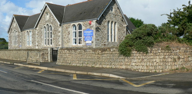
Leedstown is a village on the B3280 road between Helston and Hayle in the civil parish of Crowan (where the 2011 census population is included.), Cornwall, England. It lies north-west of Helston and south-east of Hayle at above sea level. It is located halfway between the north and south coasts. Leedstown got its name from the Duke of Leeds, who married the daughter of the St Aubyn family. The village has a primary school,a pub and a garage. The first school, described as ″a large boys school″ was funded by John St Aubyn in, or around 1813 and a girls school was built in the 1840s. A board school was opened June 1879. Designed by Mr W Carah of Crowan the school had two large classrooms. Today, the school is now known as Leedstown Community Primary School and is part of Kernow Learning Multi Academy Trust. Remains of the former Crenver and Wheal Abraham mines may be seen along the road to Crenver Grove. The former Godolphin Mine is in the woods near Godolphin Hall; copp ... [...More Info...] [...Related Items...] OR: [Wikipedia] [Google] [Baidu] |
Polmarth
Polmarth is a hamlet in the civil parish of Wendron, in west Cornwall, England.Ordnance Survey ''One-inch Map of Great Britain; Truro and Falmouth, sheet 190''. 1961 References Hamlets in Cornwall {{Kerrier-geo-stub ... [...More Info...] [...Related Items...] OR: [Wikipedia] [Google] [Baidu] |
Penmarth
Penmarth ( kw, Pollmargh) is a hamlet in Cornwall, England, United Kingdom, about west of Penryn and about south of Redruth. The hamlet is often referred to as Carnmenellis, which it was signposted as in the 1970s, and for centuries before the hamlet was known as Polmarth after the surrounding estate, from the Cornish language words ''poll'', meaning 'pool', and ''margh'', meaning 'horse'. The name Penmarth wasn't used until the Chapel was built. There is a picturesque caravan club site on the outskirts of the village called Penmarth caravans, complete with fresh water supplies and electrical hook ups. Chapel Penmarth has a Methodist chapel which was built in 1825. There is also a memorial located next to the chapel, which honours the names of eleven men from the area who died in both World Wars. Church In 1848 the foundation stone of a church for the Carnmenellis district was laid. Penmarth also had an Anglican Holy Trinity Church named Carnmenellis Church, which was bui ... [...More Info...] [...Related Items...] OR: [Wikipedia] [Google] [Baidu] |
Porkellis
Porkellis ( kw, Porthkellys) is a village in Cornwall, England, United Kingdom. It is approximately three and a half miles north-east of Helston, and is in the heart of the old Wendron mining district. The village has a pub (The Star Inn), Methodist chapel, village hall and primary school. The name ''Porkellis'' comes from the Cornish language words ''porth'', meaning 'cove' or 'gate', and ''kellys'', meaning 'lost'. Chapels Porkellis has two chapels, both of which are Grade II listed. The original chapel was built in 1814, whereas the later Wesleyan chapel was bigger and built in 1866 alongside the older one. When the latter chapel was built the original was converted into a schoolroom. Services now take place in the earlier 1814 Chapel, sympathetically refurbished as the 1866 building has been sold and is currently under renovation. The building of a church (dedicated to St Christopher) and intended to seat 120 people started in January 1882, at an estimated cost of £700 a ... [...More Info...] [...Related Items...] OR: [Wikipedia] [Google] [Baidu] |
Halwin
Halwin is a hamlet in Cornwall, England which adjoins Porkellis and is northeast of Wendron Wendron ( kw, Egloswendron (village), Pluw Wendron (parish); historically St. Wendron) is a village and civil parish in Cornwall, England, United Kingdom, to the north of Helston. The parish population at the 2011 census was 2,743. The elect ... (where the 2011 census population was included). References Hamlets in Cornwall {{Kerrier-geo-stub ... [...More Info...] [...Related Items...] OR: [Wikipedia] [Google] [Baidu] |
Carnkie, Wendron
Carnkie ( kw, Karnki) is a village in west Cornwall, England, United Kingdom. It is situated half a mile west of Rame, approximately three and a half miles west of Penryn and approximately five miles north east of Helston. It is in the civil parish of Wendron. The village has a village hall and a garage, and until 2010 also had a Methodist chapel. The name ''Carnkie'' comes from the Cornish language Cornish (Standard Written Form: or ) , is a Southwestern Brittonic language, Southwestern Brittonic language of the Celtic language family. It is a List of revived languages, revived language, having become Extinct language, extinct as a livin ... words ''karn'', meaning 'crag, tor', and ''ki'', meaning 'dog'. The chapel The old chapel at Carnkie was built in 1900 as a Bible Christian Chapel. The chapel was closed in 2010 and the last service was held on 22 August. References Villages in Cornwall {{Kerrier-geo-stub ... [...More Info...] [...Related Items...] OR: [Wikipedia] [Google] [Baidu] |
Rame, Wendron
Rame ( kw, Hordh) is a small village approximately three miles west of Penryn and five miles northeast of Helston in Cornwall, England, UK. It is located on the A394 main road. The tenement of Rame has for generations been in the possession of the Williams family of Scorrier Scorrier is a village in Cornwall, England, United Kingdom. It is in the civil parish of St Day, about northeast of the centre of Redruth and southeast of the coast at Porthtowan, on the A30 road at the junction of the A3047 road that leads we ....Langdon, A. G. (1896) ''Old Cornish Crosses''. Truro: Joseph Pollard; p. 333 References Hamlets in Cornwall {{Kerrier-geo-stub ... [...More Info...] [...Related Items...] OR: [Wikipedia] [Google] [Baidu] |
Trenear
Trenear ( kw, Trenyer) is a hamlet in the parish of Wendron in Cornwall, England, United Kingdom. The name of the hamlet comes from the Cornish language Cornish (Standard Written Form: or ) , is a Southwestern Brittonic language, Southwestern Brittonic language of the Celtic language family. It is a List of revived languages, revived language, having become Extinct language, extinct as a livin ... words ''tre'' 'farm, settlement', ''an'' 'the', and ''yer'' 'chickens'. References Hamlets in Cornwall {{Kerrier-geo-stub ... [...More Info...] [...Related Items...] OR: [Wikipedia] [Google] [Baidu] |
Wendron
Wendron ( kw, Egloswendron (village), Pluw Wendron (parish); historically St. Wendron) is a village and civil parish in Cornwall, England, United Kingdom, to the north of Helston. The parish population at the 2011 census was 2,743. The electoral ward of Wendron had a 2011 population of 4,936. History The parish of Wendron was part of the Hundred of Kerrier and was originally bounded by the parishes of Illogan, Gwennap, Stithians, Constantine, Mawgan-in-Meneage, Gunwalloe, Sithney and Crowan. Until the mid 19th-century the parish of Wendron included the town of Helston and what are now the parishes of Carnmenellis and Pencoys. The parish of Carnmenellis was created in 1846; Helston in 1848; and Pencoys in 1881. Before 1284 Edmund, Earl of Cornwall, gave the church of Wendron, with its chapels, to Rewley Abbey near Oxford. Before this it had belonged to the Earl's, Manor of Helston, which included the whole parish. The church is cruciform but was enlarged in the ... [...More Info...] [...Related Items...] OR: [Wikipedia] [Google] [Baidu] |


