|
Clipper Route
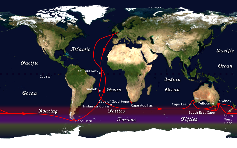
The clipper route was derived from the Brouwer Route and was sailed by clipper, clipper ships between Europe and the Far East, Australia and New Zealand. The route, devised by the Dutch navigator Hendrik Brouwer in 1611, reduced the time of a voyage between The Netherlands and Java, in the Dutch East Indies, from almost 12 months to about six months, compared to the previous Arab and Portuguese monsoon route. The clipper route ran from west to east through the Southern Ocean, making use of the consistently strong westerly winds called the Roaring Forties. Many ships and sailors were lost in the heavy conditions along the route, particularly at Cape Horn, which the clippers had to round on their return to Europe. The clipper route fell into commercial disuse with the introduction of marine steam engines, and the opening of the Suez Canal, Suez and Panama Canals. It remains the fastest sailing route around the world, and has been the route for several prominent yacht racing, yac ... [...More Info...] [...Related Items...] OR: [Wikipedia] [Google] [Baidu] |
Panama Canal
The Panama Canal () is an artificial waterway in Panama that connects the Caribbean Sea with the Pacific Ocean. It cuts across the narrowest point of the Isthmus of Panama, and is a Channel (geography), conduit for maritime trade between the Atlantic and Pacific Oceans. Lock (water navigation), Locks at each end lift ships up to Gatun Lake, an artificial fresh water lake Above mean sea level, above sea level, created by damming the Chagres River and Lake Alajuela to reduce the amount of excavation work required for the canal. Locks then lower the ships at the other end. An average of of fresh water is used in a single passing of a ship. The canal is threatened by low water levels during droughts. The Panama Canal shortcut greatly reduces the time for ships to travel between the Atlantic and Pacific oceans, enabling them to avoid the lengthy, hazardous route around the southernmost tip of South America via the Drake Passage, the Strait of Magellan or the Beagle Channel. Its ... [...More Info...] [...Related Items...] OR: [Wikipedia] [Google] [Baidu] |
30th Meridian West
The meridian 30° west of Greenwich is a line of longitude that extends from the North Pole across the Arctic Ocean, Greenland, the Atlantic Ocean, the Southern Ocean, and Antarctica to the South Pole. The 30th meridian west forms a great circle with the 150th meridian east, and it is the reference meridian for the time zone UTC-2. Between the 45th and 61st parallels north, the meridian forms the boundary between the Gander and Shanwick Oceanic air traffic control areas, and for this reason is also known as the "Molson-Guinness Line". From Pole to Pole Starting at the North Pole and heading south to the South Pole, the 30th meridian west passes through: : See also * 29th meridian west * 31st meridian west *Beyond Thirty ''Beyond Thirty'' is a short science fiction novel by American writer Edgar Rice Burroughs. It was written in 1915 and first published in ''All Around Magazine'' in February 1916, but did not appear in book form in Burroughs' lifetime. The first ... ... [...More Info...] [...Related Items...] OR: [Wikipedia] [Google] [Baidu] |
Saint Peter And Paul Rocks
In Christian belief, a saint is a person who is recognized as having an exceptional degree of holiness, likeness, or closeness to God. However, the use of the term ''saint'' depends on the context and denomination. In Anglican, Oriental Orthodox, and Lutheran doctrine, all of their faithful deceased in Heaven are considered to be saints, but a selected few are considered worthy of greater honor or emulation. Official ecclesiastical recognition, and veneration, is conferred on some denominational saints through the process of canonization in the Catholic Church or glorification in the Eastern Orthodox Church after their approval. In many Protestant denominations, and following from Pauline usage, ''saint'' refers broadly to any holy Christian, without special recognition or selection. While the English word ''saint'' (deriving from the Latin ) originated in Christianity, historians of religion tend to use the appellation "in a more general way to refer to the state of special ... [...More Info...] [...Related Items...] OR: [Wikipedia] [Google] [Baidu] |
Equator
The equator is the circle of latitude that divides Earth into the Northern Hemisphere, Northern and Southern Hemisphere, Southern Hemispheres of Earth, hemispheres. It is an imaginary line located at 0 degrees latitude, about in circumference, halfway between the North Pole, North and South Pole, South poles. The term can also be used for any other celestial body that is roughly spherical. In three-dimensional space, spatial (3D) geometry, as applied in astronomy, the equator of a rotating spheroid (such as a planet) is the parallel (circle of latitude) at which latitude is defined to be 0°. It is an imaginary line on the spheroid, equidistant from its geographical pole, poles, dividing it into northern and southern hemispheres. In other words, it is the intersection of the spheroid with the plane (geometry), plane perpendicular to its axis of rotation and midway between its geographical poles. On and near the equator (on Earth), noontime sunlight appears almost directly o ... [...More Info...] [...Related Items...] OR: [Wikipedia] [Google] [Baidu] |
Atlantic Ocean
The Atlantic Ocean is the second largest of the world's five borders of the oceans, oceanic divisions, with an area of about . It covers approximately 17% of Earth#Surface, Earth's surface and about 24% of its water surface area. During the Age of Discovery, it was known for separating the New World of the Americas (North America and South America) from the Old World of Afro-Eurasia (Africa, Asia, and Europe). Through its separation of Afro-Eurasia from the Americas, the Atlantic Ocean has played a central role in the development of human society, globalization, and the histories of many nations. While the Norse colonization of North America, Norse were the first known humans to cross the Atlantic, it was the expedition of Christopher Columbus in 1492 that proved to be the most consequential. Columbus's expedition ushered in an Age of Discovery, age of exploration and colonization of the Americas by European powers, most notably Portuguese Empire, Portugal, Spanish Empire, Sp ... [...More Info...] [...Related Items...] OR: [Wikipedia] [Google] [Baidu] |
Iceberg
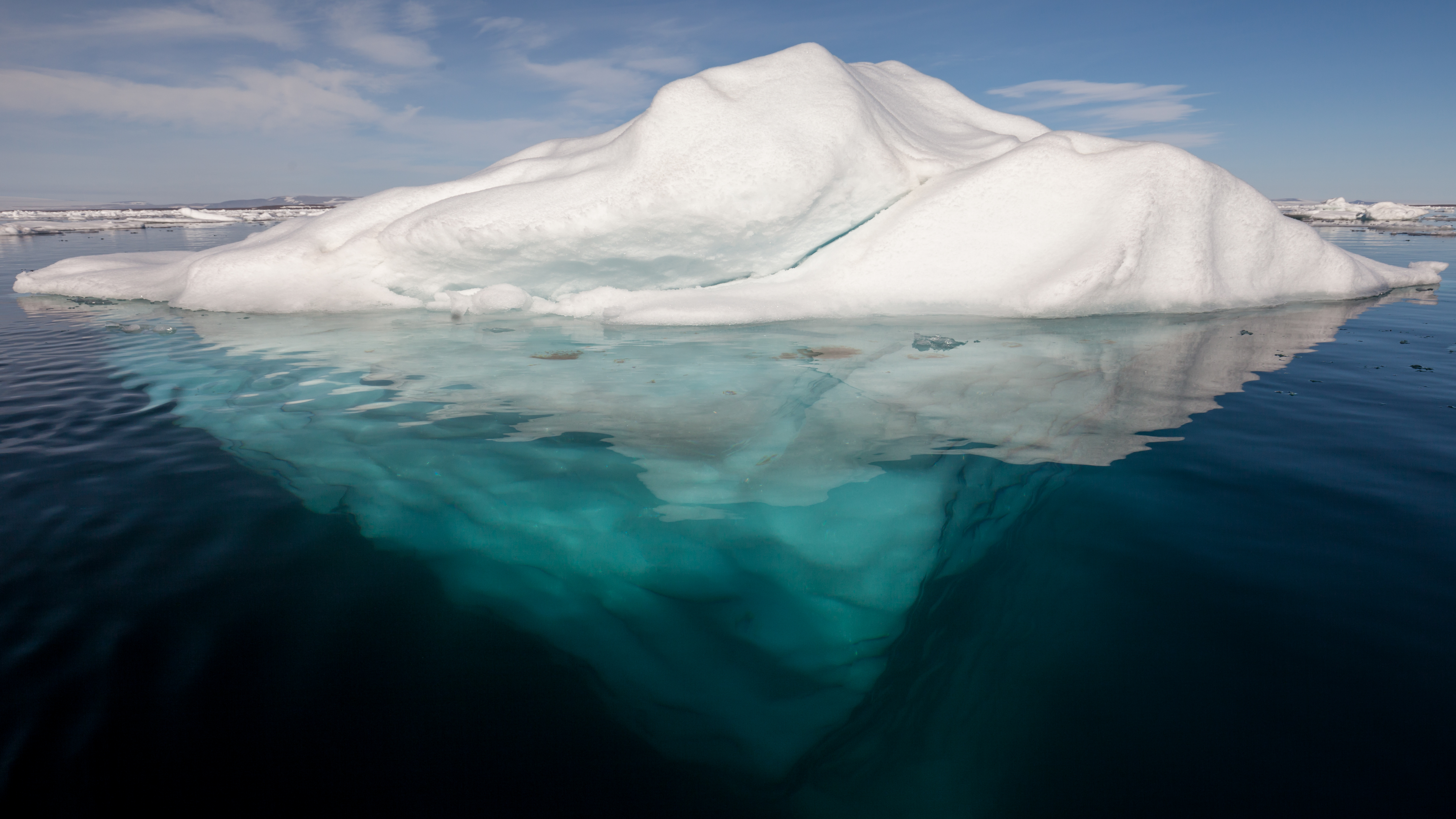
An iceberg is a piece of fresh water ice more than long that has broken off a glacier or an ice shelf and is floating freely in open water. Smaller chunks of floating glacially derived ice are called "growlers" or "bergy bits". Much of an iceberg is below the water's surface, which led to the expression " tip of the iceberg" to illustrate a small part of a larger unseen issue. Icebergs are considered a serious maritime hazard. Icebergs vary considerably in size and shape. Icebergs that calve from glaciers in Greenland are often irregularly shaped while Antarctic ice shelves often produce large tabular (table top) icebergs. The largest iceberg in recent history, named B-15, was measured at nearly in 2000. The largest iceberg on record was an Antarctic tabular iceberg measuring sighted west of Scott Island, in the South Pacific Ocean, by the USS ''Glacier'' on November 12, 1956. This iceberg was larger than Belgium. Etymology The word ''iceberg'' is a partial loan tr ... [...More Info...] [...Related Items...] OR: [Wikipedia] [Google] [Baidu] |
Cape Leeuwin
Cape Leeuwin is the most south-westerly (but not most southerly) mainland point of the Australian continent, in the state of Western Australia. Description A few small islands and rocks, the St Alouarn Islands, extend further in Flinders Bay to the east of the cape. The nearest settlement, north of the cape, is Augusta. South-east of Cape Leeuwin, the coast of Western Australia extends much further south. Cape Leeuwin is not the southernmost point of Western Australia, with that distinction belonging to West Cape Howe, which is to the southeast, near Albany. In Australia, the cape is considered where the Indian Ocean meets the Southern Ocean, but most other nations and bodies define the Southern Ocean as existing south of 60°S. Located on headland of the cape is the Cape Leeuwin Lighthouse and the buildings that were used by the lighthouse-keepers. Cape Leeuwin is considered one of the three " great capes" of the world. Use of name Cape Leeuwin is often grouped ... [...More Info...] [...Related Items...] OR: [Wikipedia] [Google] [Baidu] |
Cape Of Good Hope
The Cape of Good Hope ( ) is a rocky headland on the Atlantic Ocean, Atlantic coast of the Cape Peninsula in South Africa. A List of common misconceptions#Geography, common misconception is that the Cape of Good Hope is the southern tip of Africa, based on the misbelief that the Cape was the dividing point between the Atlantic Ocean, Atlantic and Indian Ocean, Indian oceans. In fact, the southernmost point of Africa is Cape Agulhas about to the east-southeast. The currents of the two oceans meet at the point where the warm-water Agulhas current meets the cold-water Benguela current and turns back on itself. That oceanic meeting point fluctuates between Cape Agulhas and Cape Point (about east of the Cape of Good Hope). When following the western side of the African coastline from the equator, however, the Cape of Good Hope marks the point where a ship begins to travel more eastward than southward. Thus, the first modern rounding of the cape in 1487 by Portuguese discoveries, ... [...More Info...] [...Related Items...] OR: [Wikipedia] [Google] [Baidu] |
Circumnavigation
Circumnavigation is the complete navigation around an entire island, continent, or astronomical object, astronomical body (e.g. a planet or natural satellite, moon). This article focuses on the circumnavigation of Earth. The first circumnavigation of the Earth was the Magellan's circumnavigation, Magellan Expedition, which sailed from Sanlucar de Barrameda, Spain in 1519 and returned in 1522, after crossing the Atlantic Ocean, Atlantic, Pacific Ocean, Pacific, and Indian Ocean, Indian oceans. Since the rise of commercial aviation in the late 20th century, circumnavigating Earth is straightforward, usually taking days instead of years. Today, the challenge of circumnavigating Earth has shifted towards human and technological endurance, speed, and List of circumnavigations#Miscellaneous, less conventional methods. Etymology The word ''circumnavigation'' is a noun formed from the verb ''circumnavigate'', from the past participle of the Latin verb ''circumnavigare'', from ''circum ... [...More Info...] [...Related Items...] OR: [Wikipedia] [Google] [Baidu] |


