|
Cho La (Sikkim And Tibet)
Cho La or Cho-la () is a mountain pass in the Chola range of the Himalayas. It connects the Indian state of Sikkim with China's Tibet Autonomous Region. It is situated around four miles to the north-west of Nathu La. Cho La used to be the main mountain pass between Sikkim and the Chumbi Valley (Yadong County), connecting the Sikkimese capital of Tumlong with the Chumbi town. Towards the end of the 19th century, the British developed Jelep La, and later Nathu La, as they were accessible from British India, and Cho La fell into relative disuse. History The Cho La pass was in regular used by the Sikkim royal family, which had a summer palace at Chumbi and used to spend summers there. The road between Tumlong and Chumbi via Cho La was kept in good condition. The route was also the main trading route between Sikkim and Tibet. The first Europeans to visit the Chola Pass were Archibald Campbell (Darjeeling superintendent) and Joseph Dalton Hooker (botanist) in 1849, who attemp ... [...More Info...] [...Related Items...] OR: [Wikipedia] [Google] [Baidu] |
Doklam
Doklam (), called Donglang ( zh, c=洞朗) by China, is an area in Chumbi Valley with a high plateau and a valley, lying between China's Yadong County to the north, Bhutan's Haa District to the east and India's Sikkim state to the west. Since the 1960s, China and Bhutan have disputed sovereignty over the Doklam area. The dispute has not been resolved despite several rounds of border negotiations between Bhutan and China. The area is of strategic importance to all three countries. In 1988, the People's Liberation Army, Chinese People's Liberation Army entered the Doklam plateau and successfully took control of the area. In June 2017, China attempted to extend a road on the Doklam Plateau southward, prompting Indian troops to enter the area in an attempt to stop the project, which triggered a two-month 2017 China–India border standoff, border standoff between the two sides. On 28 August, India and China withdrew their troops from the standoff in Doklam. Since then, China has co ... [...More Info...] [...Related Items...] OR: [Wikipedia] [Google] [Baidu] |
Galwan
The Galwan River flows from the disputed Aksai Chin area administered by China to the Union Territory of Ladakh, India. It originates near the caravan camping ground of Samzungling on the eastern side of the Karakoram range and flows west to join the Shyok River. The point of confluence is 102 km south of Daulat Beg Oldi. Shyok River itself is a tributary of the Indus River, making Galwan a part of the Indus River system. The narrow valley of the Galwan River as it flows through the Karakoram mountains has been a flashpoint between China and India in their border dispute. In 1962, a forward post set up by India in the upper reaches of the Galwan Valley caused an "apogee of tension" between the two countries. China attacked and eliminated the post in the 1962 war, reaching its 1960 claim line. In 2020, China attempted to advance further in the Galwan Valley,Ajai ShuklaA new and worrying chapter: Chinese intrusions in Ladakh gather pace, Business Standard, 23 May 2020: "That ... [...More Info...] [...Related Items...] OR: [Wikipedia] [Google] [Baidu] |
Siachen Base Camp (India)
Siachen Base Camp, 12,000 feet above sea level at Partapur, is a base camp of 102 Infantry Brigade (Siachen brigade) of XIV Corps of Indian Army which protects 110 km long Actual Ground Position Line (AGPL) with at least 108 forward military outposts and artillery observation posts in the disputed region of Siachen Glacier in Ladakh Union Territory of India. It is approximately 6 hours drive north from the town of Leh via one of the highest vehicle-accessible passes in the world, Khardung La at 17,582 feet. Bana Top (20,500 ft) is the highest post in the region, which requires 80 km and 20 day trek for troops. ''Pahalwan Post'' (about 20,000 ft) and posts near Indira Col (about 19,000 ft) are other high posts. ''Kumar Post'' or ''Kumar Base'', named after the Colonel Narendra "Bull" Kumar, serves as the battalion head quarter located 60 km from the Siachen base towards Indira Col. The ''Siachen Brigade'' consists of five to eight battalions of ... [...More Info...] [...Related Items...] OR: [Wikipedia] [Google] [Baidu] |
Battle Of Longewala
The Battle of Longewala (4–7 December 1971) was one of the first major engagements in the western sector during the Indo-Pakistani War of 1971, fought between assaulting Pakistani forces and Indian defenders at the Indian border post of Longewala, in the Thar Desert of Rajasthan. The battle was fought between 120 Indian soldiers accompanied by four Hawker Hunter and three HAL Marut fighter-bombers and 2,000–3,000 Pakistani soldiers accompanied by 40 tanks. A company of the Indian Army's 23rd Battalion, Punjab Regiment, commanded by Major Kuldip Singh Chandpuri an Indian Army officer, was left with the choice of either attempting to hold out until reinforced, or fleeing on foot from a Pakistani mechanized infantry force. Choosing the former, Chandpuri ensured that all his assets were correctly deployed and made the best use of his strong defensive position, as well as weaknesses created by errors in enemy tactics. He was also fortunate that an Indian Air Force forward ai ... [...More Info...] [...Related Items...] OR: [Wikipedia] [Google] [Baidu] |
Archibald Campbell (doctor)
Archibald Campbell (20 April 1805 – 5 November 1874) of the Bengal Medical Service (which became part the Indian Medical Service after 1857) was the first superintendent (1840-1862) of the sanatorium town of Darjeeling in north east India. He also took a great interest in ethnology, economic botany and the study of the region and wrote extensively in the ''Journal of the Asiatic Society of Bengal'' under the name of "Dr Campbell" or "Dr A. Campbell" which has led some authors to misidentify his first name as ArthurKennedy DaneThe Magic Mountains: Hill Stations and the British Raj Berkeley: University of California Press, c1996 1996. or even Andrew.Darwin Correspondence Project, "Letter no. 1558," accessed on 26 October 2017Letter number 1558: To J. D. Hooker. 10 March 1854./ref> Campbell is credited with the introduction of tea cultivation in Darjeeling and for playing a role in the early experiments on the cultivation of ''Cinchona''. Campbell corresponded with numerous natur ... [...More Info...] [...Related Items...] OR: [Wikipedia] [Google] [Baidu] |
Rezang La
Rezang La iarchive:dli.pahar.3148/page/n1413, Note given by the Ministry of External Affairs, New Delhi, to the Embassy of China in India, 26 July 1963. "The location of Rezang La (E 78° 51' 10" N 33° 25' 30" []) is well known... " is a mountain pass on the Line of Actual Control between Indian-administered Ladakh and the Chinese-administered Spanggur Lake basin. The pass is located on the watershed ridge of the Chushul Valley, on its east. China claims that the ridge is the boundary between the two countries, while India's claim line is further east. About 3 km southeast of Rechin La () on the same ridge is a pass leading to an adjacent valley, which China recognizes as Rezang La ( zh, t=热藏山口, p=Rèzàng Shānkǒu). About 3 km northwest of Rechin La () is a pass that was the site of a Battle of Rezang La, major battle of the 1962 Sino-Indian War. The "C" Company of India's Kumaon Regiment, 13 Kumaon battalion, made of Ahir soldiers, fought to the last ma ... [...More Info...] [...Related Items...] OR: [Wikipedia] [Google] [Baidu] |
Pangong Tso
Pangong Tso or Pangong Lake (; zh, s=班公错, p=Bān gōng cuò; ) is an endorheic lake spanning eastern Ladakh and Ngari Prefecture, West Tibet situated at an elevation of . It is long and divided into five sublakes, called ''Pangong Tso'', ''Tso Nyak'', ''Rum Tso'' (twin lakes) and ''Nyak Tso''. Approximately 50% of the length of the overall lake lies within Tibet administered by China, 40% in Indian-administered Ladakh, and the remaining 10% is disputed and is a de facto buffer zone between India and China. The lake is wide at its broadest point. All together it covers almost 700 km2. During winter the lake freezes completely, despite being saline water. It has a land-locked basin separated from the Indus River basin by a small elevated ridge, but is believed to have been part of the Indus basin in prehistoric times. Names Historically, the lake is viewed as being made up five sublakes, which are connected through narrow water channels. The name ''Pangong Tso'' o ... [...More Info...] [...Related Items...] OR: [Wikipedia] [Google] [Baidu] |
Kargil
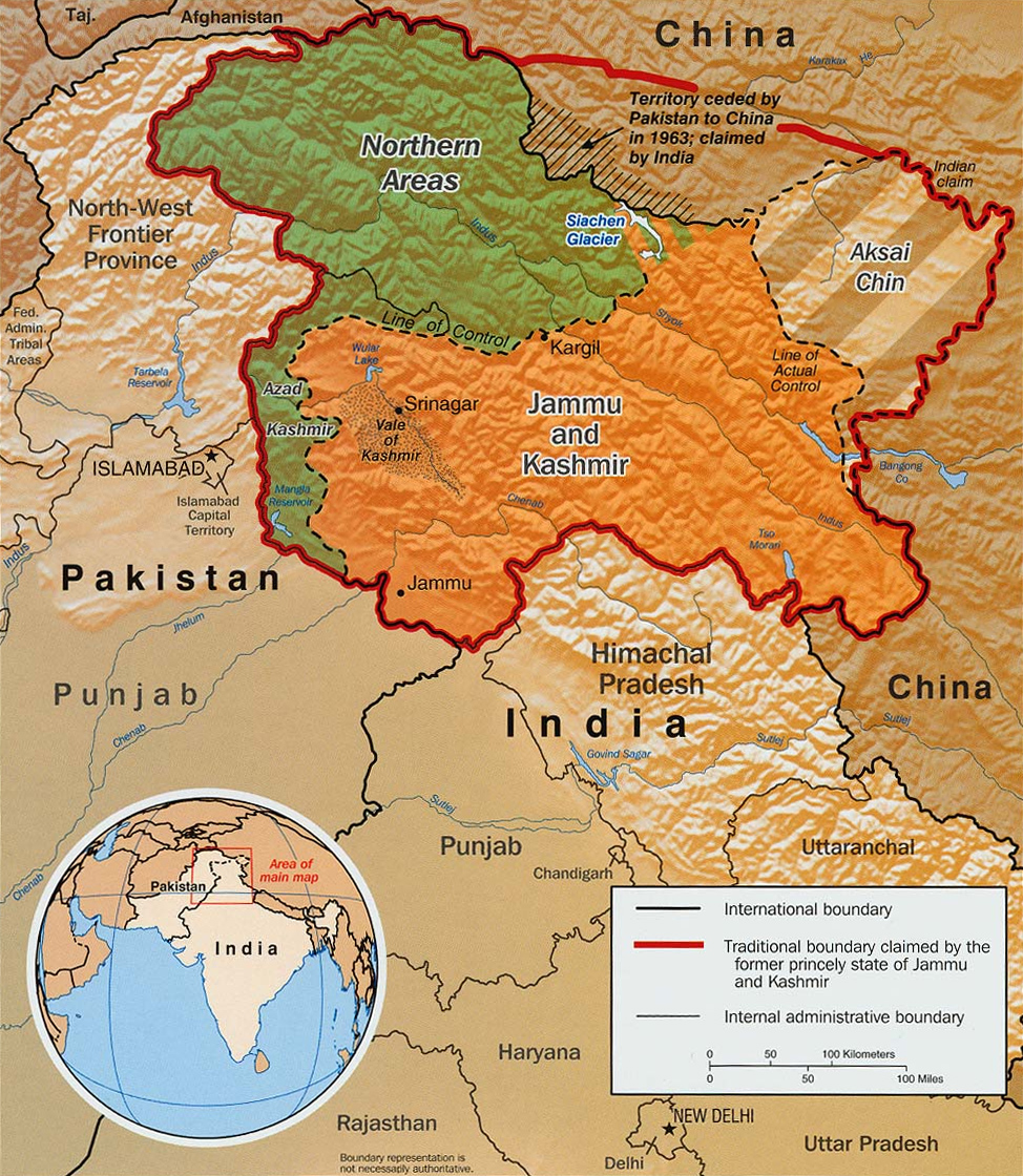
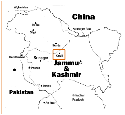
Kargil or Kargyil is a City in Indian-administered Ladakh in the disputed Kashmir region. The application of the term "administered" to the various regions of Kashmir and a mention of the Kashmir dispute is supported by the WP:TERTIARY, tertiary sources (a) through (e), reflecting WP:DUE, due weight in the coverage. Although "controlled" and "held" are also applied neutrally to the names of the disputants or to the regions administered by them, as evidenced in sources (h) through (i) below, "held" is also considered politicized usage, as is the term "occupied," (see (j) below). (a) (subscription required) Quote: "Kashmir, region of the northwestern Indian subcontinent ... has been the subject of dispute between India and Pakistan since the partition of the Indian subcontinent in 1947. The northern and western portions are administered by Pakistan and comprise three areas: Azad Kashmir, Gilgit, and Baltistan, the last two being part of a territory called the Northern Areas. A ... [...More Info...] [...Related Items...] OR: [Wikipedia] [Google] [Baidu] |
India–China Border Infrastructure
Border infrastructure along the Sino-Indian border, which has several border areas disputed by both India and China, encompasses irrigation, roads, railways, airports, natural gas and oil pipelines, electricity grids, telecommunications, and broadcasting. In the context of the border tensions between India and China, many of these infrastructure projects in the borderlands are considered strategic in nature. Commentators have noted the infrastructure gap that existed, and still exists, between the infrastructure on the borderlands of India and China. For many decades, the approach taken to the construction of border infrastructure by China and India was significantly different, however, in terms of utilizing the natural resources of the borderlands for the needs of the country, both countries are said to have a similar approach. Context The Line of Actual Control (LAC) is the disputed border between India and China, which has led to the ongoing Sino-Indian border dispute. Ther ... [...More Info...] [...Related Items...] OR: [Wikipedia] [Google] [Baidu] |
Metres Above Sea Level
Height above mean sea level is a measure of a location's vertical distance (height, elevation or altitude) in reference to a vertical datum based on a historic mean sea level. In geodesy, it is formalized as orthometric height. The zero level varies in different countries due to different reference points and historic measurement periods. Climate change and other forces can cause sea levels and elevations to vary over time. Uses Elevation or altitude above sea level is a standard measurement for: * Geographic locations such as towns, mountains and other landmarks. * The top of buildings and other structures. * Mining infrastructure, particularly underground. * Flying objects such as airplanes or helicopters below a Transition Altitude defined by local regulations. Units and abbreviations Elevation or altitude is generally expressed as "metres above mean sea level" in the metric system, or " feet above mean sea level" in United States customary and imperial units. Comm ... [...More Info...] [...Related Items...] OR: [Wikipedia] [Google] [Baidu] |
Border Outpost
A border outpost, border out post, border observation post or BOP ; STAFF WRITER; January 8, 2010; Press Trust of India (PTI) is an outpost maintained by a on its , usually one of a series placed at regular intervals, to watch over and safeguard its border with a neighboring state with which it may or may not have friendly relations. Such posts are ... [...More Info...] [...Related Items...] OR: [Wikipedia] [Google] [Baidu] |
Changgu
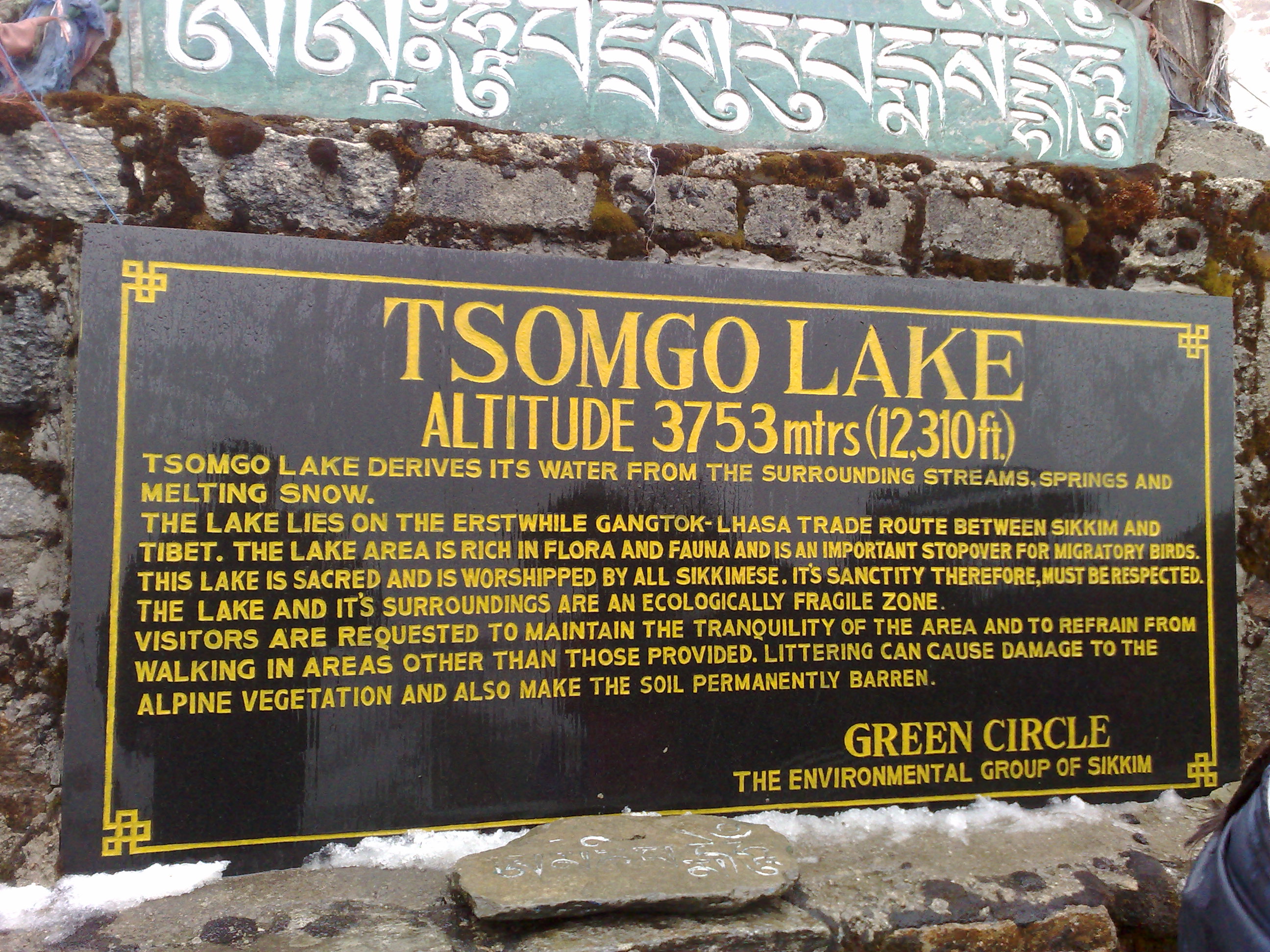
Tsomgo Lake'','' also known as Tsongmo Lake or Changgu Lake, is a glacial lake in Changu in the Gangtok district of the Indian state of Sikkim, some from the capital Gangtok. Located at an elevation of , the lake remains frozen during the winter season. The lake surface reflects different colours with change of seasons and is held in great reverence by the local Sikkimese people. Buddhist monks prognosticated after studying the changing colours of the lake. Etymology In Sikkimese language the name Tsomgo is made of two words 'Tso' meaning "lake" and 'Mgo' meaning "head" which gives the literal meaning as "source of the lake". Topography The lake is surrounded by steep mountains which are covered with snow during winter. During summer the snow cover melts and forms the source for the lake. The lake which remains frozen in winter season, sometimes extending up to May, receives an average annual precipitation of with temperatures recorded in the range of . The lake is about a ... [...More Info...] [...Related Items...] OR: [Wikipedia] [Google] [Baidu] |


