|
Central Plain Of Siam
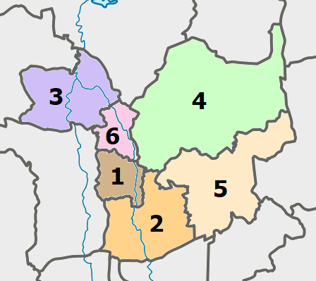
Central Thailand (Central Plain) (historically also known as Siam or Dvaravati) is one of the regions of Thailand, covering the broad alluvial plain of the Chao Phraya River. It is separated from northeast Thailand (Isan) by the Phetchabun mountain range. The Tenasserim Hills separate it from Myanmar to the west. In the north it is bounded by the Phi Pan Nam Range, one of the hilly systems of northern Thailand. The area was the heartland of the Ayutthaya Kingdom (at times referred to as Siam) and is still the dominant area of Thailand since it contains the world's most primate city, Bangkok. Definition The grouping of Thai provinces into regions follow two major systems in which Thailand is divided into either four or six regions. In the six-region system, commonly used in geographical studies, central Thailand extends from Sukhothai and Phitsanulok Provinces in the north to the provinces bordering the Gulf of Thailand in the south, excluding the mountainous provinces borde ... [...More Info...] [...Related Items...] OR: [Wikipedia] [Google] [Baidu] |
Regions Of Thailand
Thailand is variably divided into different sets of regions, the most notable of which are the six-region grouping used in geographic studies, and the four-region grouping consistent with the Monthon administrative regional grouping system formerly used by the Ministry of Interior (Thailand), Ministry of Interior. These regions are the largest subdivisions of the country. In contrast to the administrative divisions of the provinces of Thailand, the regions no longer have an administrative character, but are used for statistical or academic purposes. Grouping systems A six-region system is commonly used for geographical and scientific purposes. This system dates to 1935. It was formalised in 1977 by the National Geographical Committee, which was appointed by the National Research Council. It divides the country into the following regions: * Northern Thailand * Isan, Northeastern Thailand * Western Thailand * Central Thailand * Eastern Thailand * Southern Thailand The four-re ... [...More Info...] [...Related Items...] OR: [Wikipedia] [Google] [Baidu] |
Time In Thailand
Thailand follows UTC+07:00, which is 7 hours ahead of UTC. The local mean time in Bangkok was originally UTC+06:42:04. Thailand used this local mean time until 1920, when it changed to Indochina Time, UTC+07:00; ICT is used all year round as Thailand never observed daylight saving time. Thailand shares the same time zone with Vietnam, Cambodia, Laos, Christmas Island, and Western Indonesia, as well as parts of Russia. History * Prior to 1 January 1901, locations in Siam with an astronomical observatory would adopt local mean time based on the observatory's geographic position. Chiang Mai Province and two other provinces each had an observatory, hence, each province had its own distinct local mean time, with minutes of difference between the three locations. * On 1 April 1920, the mean time of the 105th meridian east (passing through Ubon Ratchathani Province) was adopted by Siam as the new standard time. The mean time of the 105th meridian is 7 hours ahead of Green ... [...More Info...] [...Related Items...] OR: [Wikipedia] [Google] [Baidu] |
Thai Language
Thai,In or Central Thai (historically Siamese;Although "Thai" and "Central Thai" have become more common, the older term, "Siamese", is still used by linguists, especially when it is being distinguished from other Tai languages (Diller 2008:6). "Proto-Thai" is, for example, the ancestor of all of Southwestern Tai, not just Siamese (Rischel 1998). ), is a Tai language of the Kra–Dai language family spoken by the Central Thai, Mon, Lao Wiang, Phuan people in Central Thailand and the vast majority of Thai Chinese enclaves throughout the country. It is the sole official language of Thailand. Thai is the most spoken of over 60 languages of Thailand by both number of native and overall speakers. Over half of its vocabulary is derived from or borrowed from Pali, Sanskrit, Mon and Old Khmer. It is a tonal and analytic language. Thai has a complex orthography and system of relational markers. Spoken Thai, depending on standard sociolinguistic factors such as age, gender ... [...More Info...] [...Related Items...] OR: [Wikipedia] [Google] [Baidu] |
Language
Language is a structured system of communication that consists of grammar and vocabulary. It is the primary means by which humans convey meaning, both in spoken and signed language, signed forms, and may also be conveyed through writing system, writing. Human language is characterized by its cultural and historical diversity, with significant variations observed between cultures and across time. Human languages possess the properties of Productivity (linguistics), productivity and Displacement (linguistics), displacement, which enable the creation of an infinite number of sentences, and the ability to refer to objects, events, and ideas that are not immediately present in the discourse. The use of human language relies on social convention and is acquired through learning. Estimates of the number of human languages in the world vary between and . Precise estimates depend on an arbitrary distinction (dichotomy) established between languages and dialects. Natural languages are ... [...More Info...] [...Related Items...] OR: [Wikipedia] [Google] [Baidu] |
Suphanburi Province
Suphan Buri (, ) located in the central region of Thailand, is one of the country's 76 provinces (จังหวัด, changwat), the first-level administrative divisions. Neighbouring provinces are (from north clockwise) Uthai Thani, Chai Nat, Sing Buri, Ang Thong, Phra Nakhon Si Ayutthaya, Nakhon Pathom and Kanchanaburi. As of 2018 the province counted a population of around 848,700, representing about 1.28% of the country's population. Suphan Buri Province has a moderately diverse ethnic population, the majority are of Tai, Mon, Lao, Chinese, and Khmer descent. Toponymy The word ''suphan'' originates from the Sanskrit word ''Suvarna'' (Devanagari: सुवर्ण), meaning 'gold', and the word ''buri'' from Sanskrit ''purī'' (Devanagari: पुरी), meaning 'town' or 'city'. Hence the name of the province literally means 'city of gold'. Geography The terrain of the province is mostly low river plains, with small mountain ranges in the north and the w ... [...More Info...] [...Related Items...] OR: [Wikipedia] [Google] [Baidu] |
Sing Buri Province
Sing Buri (, ) is one of the central provinces (''changwat'') of Thailand. Neighboring provinces are (from north clockwise) Nakhon Sawan, Lopburi, Ang Thong, Suphan Buri, and Chai Nat. Toponymy The word ''sing'' originates from Sanskrit ''singh'' meaning 'lion' and ''buri'', from Sanskrit ''puri'' meaning '' buri mueang'' 'fortified city' or 'town'. Hence the literal translation is 'lion city', sharing the same root as Singapore. Geography Sing Buri is located on the flat river plain of the Chao Phraya River valley. Eighty percent of the areas are wide flat areas, of which the soil is suitable for agriculture. There are a small number of slopes in swamps of different sizes. The highest average height of the area is 17 meter above sea level. Floods will occur during the rainy season. The total forest area is or 0.5 per mille of provincial area. Climate Sing Buri province has a tropical savanna climate (Köppen climate classification category Aw). Winters are dry and warm. T ... [...More Info...] [...Related Items...] OR: [Wikipedia] [Google] [Baidu] |
Nakhon Nayok Province
Nakhon Nayok (, ) is one of the central Provinces of Thailand, provinces (''changwat'') of Thailand, established by the s:Act Establishing Changwat Samut Prakan, Changwat Nonthaburi, Changwat Samut Sakhon, and Changwat Nakhon Nayok, Buddhist Era 2489 (1946), Act Establishing Changwat Samut Prakan, Changwat Nonthaburi, Changwat Samut Sakhon, and Changwat Nakhon Nayok, Buddhist Era 2489 (1946), which came into force on 9 May 1946. Neighboring provinces are (from north clockwise) Saraburi province, Saraburi, Nakhon Ratchasima province, Nakhon Ratchasima, Prachinburi province, Prachinburi, Chachoengsao province, Chachoengsao, and Pathum Thani province, Pathum Thani. Nakhon Nayok is known for waterfalls and fruit varieties. Nakon Nayok is a nearby province to Bangkok and has various tourist attractions. Khao Yai National Park, Thailands oldest national park is in partly in Nakhon Nayok province and attracts many tourists. Khun Dan Prakarn Chon Dam is another tourist attraction 2 hours ... [...More Info...] [...Related Items...] OR: [Wikipedia] [Google] [Baidu] |
Chai Nat Province
Chai Nat (, ) is one of the central provinces (''changwat'') of Thailand. Neighbouring provinces are (from north clockwise) Nakhon Sawan, Sing Buri, Suphan Buri, and Uthai Thani. The town of Chai Nat is 188 km north of Bangkok. Geography Chai Nat is on the flat river plain of central Thailand's Chao Phraya River valley. In the south of the province, the Chao Phraya Dam (formerly Chai Nat Dam) impounds the Chao Phraya River, both for flood control as well as to divert water into the country's largest irrigation system for the irrigation of rice paddies in the lower river valley. The dam, part of the Greater Chao Phraya Project, was finished in 1957 and was the first dam constructed in Thailand. The total forest area is or 2.6 percent of the provincial area. History Chai Nat was first established during the Ayutthaya period and was used as a successful base of operations for confronting the Burmese army. As the Burmese were defeated every time, the area earned the name ... [...More Info...] [...Related Items...] OR: [Wikipedia] [Google] [Baidu] |
Phra Nakhon Si Ayutthaya Province
Phra Nakhon Si Ayutthaya, or locally and simply Ayutthaya (historically Juthia or Judia), is one of the central provinces (''changwat'') of Thailand. Neighboring provinces are (from north clockwise) Ang Thong, Lopburi, Saraburi, Pathum Thani, Nonthaburi, Nakhon Pathom and Suphan Buri. Toponymy The name ''Ayutthaya'' derives from the Sanskrit word '' Ayodhyā'', found in the Ramayana, which means "the invincible ity. Grammatically, this word is composed of the morphemes ''a-'' 'not' + ''yodhya'' 'defeatable' (from the root ''yudh-'' 'to fight') + ''ā'', a feminine suffix. Geography Phra Nakhon Si Ayutthaya, covering , is on the flat river plain of the Chao Phraya River valley. The presence of the Lopburi and Pa Sak rivers makes the province a major rice farming area. The total forest area is or 0.02 per mille of provincial area. History Ayutthaya was founded in 1350 by King U-Thong. However, the establishment of Ayutthaya is far older than 14th century. E ... [...More Info...] [...Related Items...] OR: [Wikipedia] [Google] [Baidu] |

