|
Campo Do Gerês
Campo do Gerês is a Portuguese ''freguesia'' ("civil parish"), located in the municipality of Terras de Bouro in the district of Braga. The population in 2011 was 149, in an area of 62.38 km2. Description The parish is located within the Peneda-Gerês National Park, on the east bank of the Homem River. It is believed to be an ancient settlement, thanks to numerous findings that testify to an archaic, persistent and continuous human occupation of its territory, from prehistoric times until today. Some of the main pieces of evidence of this are the megalithic tombs of Bouça da Chã, Funde Vila and Bouça do Cruzeiro, as well as Castro de Calcedónia. Located north of Campo do Gerês, the dam A dam is a barrier that stops or restricts the flow of surface water or underground streams. Reservoirs created by dams not only suppress floods but also provide water for activities such as irrigation, human consumption, industrial use, aqua ... of Vilarinho da Furna consti ... [...More Info...] [...Related Items...] OR: [Wikipedia] [Google] [Baidu] |
Norte Region, Portugal
The North Region ( ) or Northern Portugal is the most populous region in Portugal, ahead of Lisbon, and the third most extensive by area. The region has 3,576,205 inhabitants according to the 2017 census, and its area is with a density of 173 inhabitants per square kilometre. It is one of five regions of Mainland Portugal ( NUTS II subdivisions). Its main population center is the urban area of Porto, with about one million inhabitants; it includes a larger political metropolitan region with 1.8 million, and an urban-metropolitan agglomeration with 2.99 million inhabitants, including Porto and neighboring cities, such as Braga, Guimarães and Póvoa de Varzim. The Commission of Regional Coordination of the North (CCDR-N) is the agency that coordinates environmental policies, land-use planning, cities and the overall development of this region, supporting local governments and associations. Northern Portugal is a culturally varied region. It is a land of dense vegetation and prof ... [...More Info...] [...Related Items...] OR: [Wikipedia] [Google] [Baidu] |
Cávado Subregion
{{geodis ...
Cávado may refer to: * Cávado Subregion * Cávado River The Cávado River (, ) is a river located in northern Portugal. It has its source in Serra do Larouco at an elevation of above sea level. It runs from Fonte da Pipa, near the triangulation station Larouco, to its mouth into the Atlantic Oce ... [...More Info...] [...Related Items...] OR: [Wikipedia] [Google] [Baidu] |
Braga District
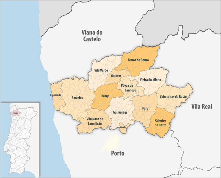
The district of Braga ( ) is a district in the northwest of Portugal. The district capital is the city of Braga, and it is bordered by the district of Viana do Castelo in the north, Vila Real in the east, Galicia (a Spanish autonomous community) in the northeast and Porto in the south. Its area is and it has a population of 831,368. It takes its name from the Bracarii, a Celtic tribe. Municipalities The district comprises 14 municipalities A municipality is usually a single administrative division having municipal corporation, corporate status and powers of self-government or jurisdiction as granted by national and regional laws to which it is subordinate. The term ''municipality' ...: * Amares * Barcelos * Braga * Cabeceiras de Basto * Celorico de Basto * Esposende * Fafe * Guimarães * Póvoa de Lanhoso * Terras de Bouro * Vieira do Minho * Vila Nova de Famalicão * Vila Verde * Vizela Geography The district of Braga has a very rugged terrain, domin ... [...More Info...] [...Related Items...] OR: [Wikipedia] [Google] [Baidu] |
Terras De Bouro
Terras de Bouro (), also known as Terras de Boiro, is a municipality in the district of Braga in Portugal. The population in 2011 was 7,253, in an area of 277.46 km². It is bordered to the north by Ponte da Barca and Spain, to the east by Montalegre, to the south by Vieira do Minho, to the southwest by Amares, and to the west by Vila Verde. Its municipal seat of power is in Town of Terras de Bouro , located in the Moimenta parish. Said town was previously named Vila da Cova, which made Terras de Bouro the only municipality in Portugal with a unique name (instead of simply being named after its seat of power). The town's name would eventually be changed in 2005 to match that of the municipality, getting rid of this exception. The present Mayor is Manuel Tibo, elected by the PSD. The municipal holiday is 20 October, day that celebrates the granting of a charter by King D. Manuel I in 1514 . History The Germanic tribe of the Buri accompanied the Suebi in their invasion o ... [...More Info...] [...Related Items...] OR: [Wikipedia] [Google] [Baidu] |
Ponte Dos Eixoes
Ponte, a word meaning ''bridge'' in Italian, Portuguese, and Galician languages, may refer to: Places England *Pontefract, a town in the Metropolitan City of Wakefield France *Ponte Leccia, a civil parish (hameau) in the department of Haute-Corse Italy ;Municipalities * Ponte (BN), in the Province of Benevento *Ponte Buggianese, in the Province of Pistoia *Ponte dell'Olio, in the Province of Piacenza *Ponte di Legno, in the Province of Brescia *Ponte di Piave, in the Province of Treviso *''Ponte Gardena'', Italian name for Waidbruck, in South Tyrol *Ponte in Valtellina, in the Province of Sondrio *Ponte Lambro, in the Province of Como *Ponte nelle Alpi, in the Province of Belluno *Ponte Nizza, in the Province of Provincia di Pavia *Ponte Nossa, in the Province of Bergamo *Ponte San Nicolò, in the Province of Padua *Ponte San Pietro, in the Province of Bergamo ;Civil parishes and quarters *Ponte (Rome) Ponte, a word meaning ''bridge'' in Italian, Portuguese, and Galician langua ... [...More Info...] [...Related Items...] OR: [Wikipedia] [Google] [Baidu] |
Portugal
Portugal, officially the Portuguese Republic, is a country on the Iberian Peninsula in Southwestern Europe. Featuring Cabo da Roca, the westernmost point in continental Europe, Portugal borders Spain to its north and east, with which it shares Portugal-Spain border, the longest uninterrupted border in the European Union; to the south and the west is the North Atlantic Ocean; and to the west and southwest lie the Macaronesia, Macaronesian archipelagos of the Azores and Madeira, which are the two Autonomous Regions of Portugal, autonomous regions of Portugal. Lisbon is the Capital city, capital and List of largest cities in Portugal, largest city, followed by Porto, which is the only other Metropolitan areas in Portugal, metropolitan area. The western Iberian Peninsula has been continuously inhabited since Prehistoric Iberia, prehistoric times, with the earliest signs of Human settlement, settlement dating to 5500 BC. Celts, Celtic and List of the Pre-Roman peoples of the Iberia ... [...More Info...] [...Related Items...] OR: [Wikipedia] [Google] [Baidu] |
Freguesia
(), usually translated as "parish" or "civil parish", is the third-level administrative subdivision of Portugal, as defined by the 1976 Constitution. It is also the designation for local government jurisdictions in the former Portuguese overseas territories of Cape Verde and Macau (until 2001). In the past, it was also an administrative division of the other Portuguese overseas territories. The civil parishes and communities in England and Wales and in the Spanish autonomous communities of Galicia and Asturias is similar to a in Portugal. The average land area of a Portuguese parish is about and an average population of about 3,386 people. The largest parish by area is Alcácer do Sal (Santa Maria do Castelo e Santiago) e Santa Susana, with a land area of , and the smallest parish by area is São Bartolomeu (Borba), with a land area of . The most populous parish is Algueirão - Mem Martins, with a population of 68,649 people and the least populous is Mosteiro, with a popul ... [...More Info...] [...Related Items...] OR: [Wikipedia] [Google] [Baidu] |
Peneda-Gerês National Park
Peneda-Gerês National Park (, ), also known simply as Gerês, is a national park in Norte Region, Portugal. Created in May 1971, it is the oldest protected area and the only national park in Portugal. It covers an area of , occupying the Districts of Portugal, Districts of Viana do Castelo District, Viana do Castelo, Braga District, Braga, and Vila Real District, Vila Real and bordering the Spanish Baixa Limia – Serra do Xurés natural park to the north, with which forms the UNESCO biosphere reserve of Gerês-Xurés. Peneda-Gerês was given its name by its two main granite massifs, the Serra da Peneda and the Serra do Gerês which, with the Serra Amarela and the Serra do Soajo, constitute the park's highest peaks. On the other hand, the precipitous valleys, crossed by high flowing streams, host lush temperate broadleaf and mixed forests of oak and pine, being one of the last strongholds of the typical Atlantic European flora of Portugal, contrasting with an evolving Mediterrane ... [...More Info...] [...Related Items...] OR: [Wikipedia] [Google] [Baidu] |
Homem River
Homem is a surname meaning "man" in Portuguese. Notable people with the surname include: * Diogo Homem (1521–1576), Portuguese cartographer *Guy-Manuel de Homem-Christo (born 1974), French musician, record producer, singer, songwriter, DJ, film director and composer *Lopo Homem Lopo Homem (c. 1497 - c. 1572) was a 16th-century Portuguese cartographer and cosmographer based in Lisbon and best known for his work on the Miller Atlas. Biography Homem is estimated to have been born c. 1497, possibly into a noble famil ... ( 1497– 1572), Portuguese cartographer {{surname Portuguese-language surnames ... [...More Info...] [...Related Items...] OR: [Wikipedia] [Google] [Baidu] |
Megalith
A megalith is a large stone that has been used to construct a prehistoric structure or monument, either alone or together with other stones. More than 35,000 megalithic structures have been identified across Europe, ranging geographically from Sweden in the north to the Mediterranean Sea in the south. The word was first used in 1849 by the British antiquarian Algernon Herbert in reference to Stonehenge and derives from the Ancient Greek words " mega" for great and " lithos" for stone. Most extant megaliths were erected between the Neolithic period (although earlier Mesolithic examples are known) through the Chalcolithic period and into the Bronze Age. Types and definitions While "megalith" is often used to describe a single piece of stone, it also can be used to denote one or more rocks hewn in definite shapes for special purposes. It has been used to describe structures built by people from many parts of the world living in many different periods. The most widely known ... [...More Info...] [...Related Items...] OR: [Wikipedia] [Google] [Baidu] |
Vilarinho Da Furna
Vilarinho da Furna (alternately called ''Vilarinho das Furnas'') was a former village, located in the civil parish of Campo de Gerês, in the municipality of Terras de Bouro, in the northern Portuguese district of Braga. Located on the banks of the rivers Homem and Ribeira do Eido, in 1972, it was intentionally submerged by the Portuguese state during the course of filling a reservoir of the same name. Although still legally held by the former villages, the lands are inundated and the ruins of the former village are only visible during the dry season, when it emerges as a tourist attraction. History Oral tradition suggests that the village was founded in the 1st century during the Visigothic settlement of the region, a time when the nearby Roman road (''Via Nova XVIII'') was extended. According to this history, seven men settled present-day Portela do Campo, but following a dispute, four decided to settle downstream of the Rio Homem, establishing Vilarinho da Furna. Little eviden ... [...More Info...] [...Related Items...] OR: [Wikipedia] [Google] [Baidu] |


