|
Brazilian Antarctica
Brazilian Antarctica ( or ''Antártica Brasileira'') is the Antarctic territory south of 60°S, and from 28°W to 53°W, proposed as a "zone of interest" by geopolitical scholar Therezinha de Castro. While the substance of that designation has never been precisely defined, it does not formally contradict the Argentine and British claims geographically overlapping with that zone (the zone shares a border but does not overlap with the Chilean Antarctic Territory to its west). The country formally expressed its reservations with respect to its territorial rights in Antarctica when it acceded to the Antarctic Treaty on 16 May 1975, making the first official mention of the Frontage Theory, which states (simplified) that sovereignty over each point in Antarctica properly (bar the South Pole itself) belongs to the first country whose non-Antarctic territory one would reach when travelling north in a straight line from such a point. [...More Info...] [...Related Items...] OR: [Wikipedia] [Google] [Baidu] |
Antarctic Treaty System
The Antarctic Treaty and related agreements, collectively known as the Antarctic Treaty System (ATS), regulate international relations with respect to Antarctica, Earth's only continent without a native human population. It was the first arms control agreement established during the Cold War, designating the continent as a scientific preserve, establishing freedom of scientific investigation, and banning Military activity in the Antarctic, military activity; for the purposes of the treaty system, Antarctica is defined as all the land and ice shelf, ice shelves south of 60th parallel south, 60°S latitude. Since September 2004, the Antarctic Treaty Secretariat, which implements the treaty system, is headquartered in Buenos Aires, Argentina. The main treaty was opened for signature on 1 December 1959, and officially coming into force, entered into force on 23 June 1961. The original signatories were the 12 countries active in Antarctica during the International Geophysical Year ... [...More Info...] [...Related Items...] OR: [Wikipedia] [Google] [Baidu] |
Antarctic Treaty
The Antarctic (, ; commonly ) is the polar region of Earth that surrounds the South Pole, lying within the Antarctic Circle. It is diametrically opposite of the Arctic region around the North Pole. The Antarctic comprises the continent of Antarctica, the Kerguelen Plateau, and other island territories located on the Antarctic Plate or south of the Antarctic Convergence. The Antarctic region includes the ice shelves, waters, and all the island territories in the Southern Ocean situated south of the Antarctic Convergence, a zone approximately wide and varying in latitude seasonally. The region covers some 20 percent of the Southern Hemisphere, of which 5.5 percent (14 million km2) is the surface area of the Antarctica continent itself. All of the land and ice shelves south of 60°S latitude are administered under the Antarctic Treaty System. Biogeographically, the Antarctic realm is one of eight biogeographic realms on Earth's land surface. Climate change in Antar ... [...More Info...] [...Related Items...] OR: [Wikipedia] [Google] [Baidu] |
Antarctic Peninsula
The Antarctic Peninsula, known as O'Higgins Land in Chile and Tierra de San Martin in Argentina, and originally as Graham Land in the United Kingdom and the Palmer Peninsula in the United States, is the northernmost part of mainland Antarctica. The Antarctic Peninsula is part of the larger peninsula of West Antarctica, protruding from a line between Cape Adams (Weddell Sea) and a point on the mainland south of the Eklund Islands. Beneath the ice sheet that covers it, the Antarctic Peninsula consists of a string of bedrock islands; these are separated by deep channels whose bottoms lie at depths considerably below current sea level. They are joined by a grounded ice sheet. Tierra del Fuego, the southernmost tip of South America, is about away across the Drake Passage. The Antarctic Peninsula is in area and 80% ice-covered. The marine ecosystem around the western continental shelf of the Antarctic Peninsula (WAP) has been subjected to rapid Climate change in Antarctica, clima ... [...More Info...] [...Related Items...] OR: [Wikipedia] [Google] [Baidu] |
King George Island (Antarctica)
King George Island ( Argentinian Spanish: Isla 25 de Mayo, Chilean Spanish: Isla Rey Jorge, Russian: Ватерло́о Vaterloo) is the largest of the South Shetland Islands, lying off the coast of Antarctica in the Southern Ocean. The island was named after King George III. Geography King George island has three major bays, Maxwell Bay, Admiralty Bay, and King George Bay. Admiralty Bay contains three fjords, and is protected as an Antarctic Specially Managed Area under the Protocol on Environmental Protection to the Antarctic Treaty. The Fildes Peninsula, long, forms the SW extremity of the island. It was named from association with nearby Fildes Strait by the UK-APC in 1960. History Chilean scientists have claimed that Amerinds visited the area, citing stone artifacts recovered from bottom-sampling operations in Admiralty Bay; however, the artifacts—two arrowheads—were later found to have been planted. The island was first claimed for Britain on 16 Oct ... [...More Info...] [...Related Items...] OR: [Wikipedia] [Google] [Baidu] |
Admiralty Bay (South Shetland Islands)
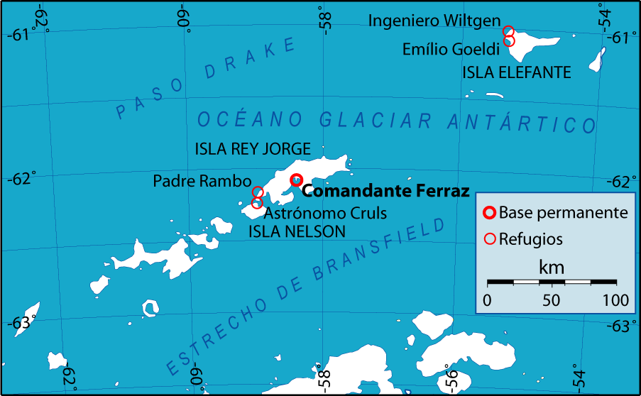
Admiralty Bay is an irregular bay, wide at its entrance between Demay Point and Martins Head, indenting the southern coast of King George Island for , in the South Shetland Islands of Antarctica. The name appears on a map of 1822 by Captain George Powell, a British sailor, and is now established in international usage. The Henryk Arctowski Polish Antarctic Station is situated on the bay, as is the Comandante Ferraz Brazilian Antarctic Base. It has been designated an Antarctic Specially Managed Area (ASMA 1). Description The bay has three fjords: Martel, Mackellar, and Ezcurra. A mariner's guide to the region pronounced the bay to have the best anchorage of any in the South Shetlands, "being well-sheltered all around and having moderate depths over a bottom of good, stiff clay. Ice from the glaciers is frequently troublesome." Chilean scientists have claimed that Amerinds visited the area, due to stone artifacts recovered from bottom-sampling operations in the bay. ... [...More Info...] [...Related Items...] OR: [Wikipedia] [Google] [Baidu] |
UN/LOCODE
UN/LOCODE, the United Nations Code for Trade and Transport Locations, is a geographic coding scheme developed and maintained by United Nations Economic Commission for Europe (UNECE). UN/LOCODE assigns codes to locations used in trade and transport with functions such as seaports, rail and road terminals, airports, Postal Exchange Office and border crossing points. The first issue in 1981 contained codes for 8,000 locations. The version from 2011 contained codes for about 82,000 locations. Structure UN/LOCODEs have five characters. The first two letters code a country by the table defined in ISO 3166-1 alpha-2. The three remaining characters code a location within that country. Letters are preferred, but if necessary digits 2 through 9 may be used, excluding "0" and "1" to avoid confusion with the letters "O" and "I" respectively. For each country there can be a maximum of 17,576 entries using only letters (26×26×26), or 39,304 entries using letters and digits (34×34×34). ... [...More Info...] [...Related Items...] OR: [Wikipedia] [Google] [Baidu] |
Comandante Ferraz Brazilian Antarctic Base
The Comandante Ferraz Antarctic Station () is a permanent Antarctic research station named after the Brazilian Navy Commander Luís Antônio de Carvalho Ferraz (1940–1982), who visited Antarctica many times with the British exploration team and managed to convince his government to create a self-guided Brazilian Antarctic Program. Located in Admiralty Bay (South Shetland Islands), Admiralty Bay (), King George Island (Antarctica), King George Island (), near the tip of the Antarctic Peninsula, 130 km north of the peninsula, the station began operating on 6 February 1984, brought to Antarctica in modules by the oceanographic ship Barão de Teffé (H-42), ''Barão de Teffé'' and several other Brazilian naval ships. It now houses about 64 people, including researchers, technicians and staff, military and civilians. History The station was named after Brazilian Navy, Navy Commander Luís Antônio de Carvalho Ferraz, a Hydrography, hydrographer and oceanographer who visited An ... [...More Info...] [...Related Items...] OR: [Wikipedia] [Google] [Baidu] |
South Pole
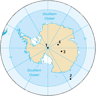
The South Pole, also known as the Geographic South Pole or Terrestrial South Pole, is the point in the Southern Hemisphere where the Earth's rotation, Earth's axis of rotation meets its surface. It is called the True South Pole to distinguish from the south magnetic pole. The South Pole is by definition the southernmost point on the Earth, lying antipode (geography), antipodally to the North Pole. It defines geodetic latitude 90° South, as well as the direction of true south. At the South Pole all directions point North; all lines of longitude converge there, so its longitude can be defined as any degree value. No time zone has been assigned to the South Pole, so any time can be used as the local time. Along tight latitude circles, clockwise is east and counterclockwise is west. The South Pole is at the center of the Southern Hemisphere. Situated on the continent of Antarctica, it is the site of the United States Amundsen–Scott South Pole Station, which was established in 19 ... [...More Info...] [...Related Items...] OR: [Wikipedia] [Google] [Baidu] |
Chilean Antarctic Territory
The Chilean Antarctic Territory, or Chilean Antarctica (, ), is a part of West Antarctica and nearby islands claimed by Chile. It comprises the region south of 60th parallel south, 60°S latitude and between longitudes 53rd meridian west, 53°W and 90th meridian west, 90°W, partially overlapping the Antarctic claims of Argentina (Argentine Antarctica) and the United Kingdom (British Antarctic Territory). It constitutes the ''Antártica (commune), Antártica'' Communes of Chile, commune of Chile. The territory covers the South Shetland Islands, the Antarctic Peninsula (called O'Higgins Land——in Chile), and the adjacent islands of Alexander Island, Charcot Island and Ellsworth Land, among others. Its boundaries are defined by Decree 1747, issued on 6 November 1940 and published on 21 June 1955 by the Ministry of Foreign Affairs (Chile), Ministry of Foreign Affairs: The commune of Antártica has an area of . If reckoned as Chilean national territory, it comprises 62.28% of th ... [...More Info...] [...Related Items...] OR: [Wikipedia] [Google] [Baidu] |
Antarctic
The Antarctic (, ; commonly ) is the polar regions of Earth, polar region of Earth that surrounds the South Pole, lying within the Antarctic Circle. It is antipodes, diametrically opposite of the Arctic region around the North Pole. The Antarctic comprises the continent of Antarctica, the Kerguelen Plateau, and other list of Antarctic and Subantarctic islands, island territories located on the Antarctic Plate or south of the Antarctic Convergence. The Antarctic region includes the ice shelf, ice shelves, waters, and all the island territories in the Southern Ocean situated south of the Antarctic Convergence, a zone approximately wide and varying in latitude seasonally. The region covers some 20 percent of the Southern Hemisphere, of which 5.5 percent (14 million km2) is the surface area of the Antarctica continent itself. All of the land and ice shelf, ice shelves south of 60th parallel south, 60°S latitude are administered under the Antarctic Treaty System. Biogeograph ... [...More Info...] [...Related Items...] OR: [Wikipedia] [Google] [Baidu] |
British Antarctica
The British Antarctic Territory (BAT) is a sector of Antarctica claimed by the United Kingdom as one of its 14 British Overseas Territories, of which it is by far the largest by area. It comprises the region south of 60°S latitude and between longitudes and , forming a wedge shape that extends to the South Pole, overlapped by the Antarctic claims of Argentina (Argentine Antarctica) and Chile (Chilean Antarctic Territory). The claim to the region has been suspended since the Antarctic Treaty came into force in 1961. The territory was formed on 3 March 1962, although the UK's claim to this portion of the Antarctic dates back to letters patent of 1908 and 1917. The area now covered by the Territory includes three regions which, before 1962, were administered by the British as separate dependencies of the Falkland Islands: Graham Land, the South Orkney Islands, and the South Shetland Islands. The United Kingdom's claim to the region has been suspended since the Antarc ... [...More Info...] [...Related Items...] OR: [Wikipedia] [Google] [Baidu] |
Argentine Antarctica
Argentine Antarctica ( or ) is an area on Antarctica claimed by Argentina as part of its national territory. It consists of the Antarctic Peninsula and a triangular section extending to the South Pole, delimited by the 25th meridian west, 25° West and 74th meridian west, 74° West meridians and the 60th parallel south, 60° South parallel. This region overlaps with British Antarctic Territory, British and Chilean Antarctic Territory, Chilean claims in Antarctica. None of these claims have widespread international recognition. Argentina's Antarctic claim is based on its presence on a base on Laurie Island in the South Orkney Islands since 1904, along with the area's proximity to the South American continent, and is subject to the Antarctic Treaty. However the presence on the Antarctic mainland was established in 1951, and the official claim on the mainland was started to be formulated on 1941, with several changes and was officially declared on 1957. Administratively, Argen ... [...More Info...] [...Related Items...] OR: [Wikipedia] [Google] [Baidu] |


