|
Auckland CBD
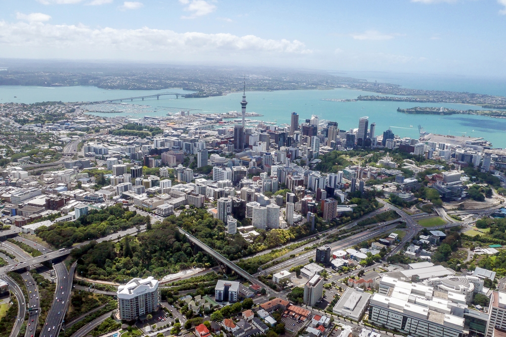
The Auckland Central Business District (CBD), or Auckland city centre, is the geographical and economic heart of the Auckland, Auckland metropolitan area. It is the area in which Auckland was established in 1840, by William Hobson on land gifted by Tangata whenua, ''mana whenua'' ''hapū'' Ngāti Whātua Ōrākei. It is New Zealand's leading financial hub, and the centre of the Economy of New Zealand, country's economy; the GDP of the Auckland Region was NZD$139 billion in the year ending September 2023. The CBD is one of the most densely developed places in New Zealand, with many commercial and some residential developments packed into a space of only . The area is made up of the city's largest concentration of skyscrapers and businesses. Bounded by several major motorways and by the harbour coastline in the north, it is surrounded further out by mostly suburban areas; it is bounded on the North by Waitematā Harbour, east by Parnell, New Zealand, Parnell, southeast by Grafton, ... [...More Info...] [...Related Items...] OR: [Wikipedia] [Google] [Baidu] |
Central Business District
A central business district (CBD) is the Commerce, commercial and business center of a city. It contains commercial space and offices, and in larger cities will often be described as a financial district. Geographically, it often coincides with the "city centre" or "downtown". However, these concepts are not necessarily synonymous: many cities have a central ''business'' district located away from its traditional city center, and there may be multiple CBDs within a single urban area. The CBD will often be highly accessible and have a large variety and concentration of specialised goods and services compared to other parts of the city. Midtown Manhattan is the world's largest central business district. In the City of London, the largest concentration of economic output in the world is held there, with many headquarters of major financial and law firms being based in the City. In Chicago, the Chicago Loop is the second-largest central business district in the United States. It is ... [...More Info...] [...Related Items...] OR: [Wikipedia] [Google] [Baidu] |
Newton, New Zealand
Newton is a small suburb of Auckland, New Zealand, under the local governance of the Auckland Council. Since the construction of the Central Motorway Junction in 1965–75, Newton has been divided into two parts, and as a result, lost much of its size and coherence. The northern part is centred on Karangahape Road, and the southern part on Newton Road and upper Symonds Street. Both Karangahape and Newton Roads intersect with Symonds Street to the east. Newton Road joins the Great North/Ponsonby and Karangahape Road intersection to the west. At the southern end of Symonds Street are the Symonds Street Shops. Here Upper Symonds Street has two major intersections with other arterial roads: Newton Road and Khyber Pass Road, and Mt Eden Road and New North Road. History In the 19th century Newton was the name given to a slightly different area - stretching from what is now called Surrey Crescent to Eden Terrace. References to Newton can therefore describe different areas ... [...More Info...] [...Related Items...] OR: [Wikipedia] [Google] [Baidu] |
Commercial Bay
Commercial Bay () was a historic bay on the southern side of the Waitematā Harbour that defined the original extent of the Auckland waterfront in Auckland, New Zealand. Today, the name Commercial Bay refers to the heavily developed area around lower Queen Street and Viaduct Harbour. The historic bay was framed by two substantial headlands, Smale's Point dividing it from Freemans Bay in the west and Point Britomart dividing it from Official Bay and Mechanics Bay in the east.Auckland's waterfront and its changing face (Auckland City Library, includes various further references) The Waihorotiu Stream drained the va ... [...More Info...] [...Related Items...] OR: [Wikipedia] [Google] [Baidu] |
Land Reclamation
Land reclamation, often known as reclamation, and also known as land fill (not to be confused with a waste landfill), is the process of creating new Terrestrial ecoregion, land from oceans, list of seas, seas, Stream bed, riverbeds or lake beds. The land reclaimed is known as reclamation ground, reclaimed land, or land fill. History In ancient Egypt, the rulers of the Twelfth Dynasty of Egypt, Twelfth Dynasty (c. 2000–1800 BC) undertook a far-sighted land reclamation scheme to increase agricultural output. They constructed levees and canals to connect the Faiyum Oasis, Faiyum with the Bahr Yussef waterway, diverting water that would have flowed into Lake Moeris and causing gradual evaporation around the lake's edges, creating new farmland from the reclaimed land. A similar land reclamation system using dams and drainage canals was used in the Greek Lake Copais, Copaic Basin during the Middle Helladic period, Middle Helladic Period (c. 1900–1600 BC). Another early large-s ... [...More Info...] [...Related Items...] OR: [Wikipedia] [Google] [Baidu] |
Auckland City Council
Auckland City Council was the local government authority for Auckland City, New Zealand, from 1989 to 1 November 2010, when it and Auckland's six other city and district councils were amalgamated to form the Auckland Council. It was an elected body representing the 404,658 residents (2006 census) of the city, which included some of the Hauraki Gulf islands, such as Waiheke Island and Great Barrier Island. It was chaired by the Mayor of Auckland City. Elections The councillors and the mayor of Auckland City were elected every three years. In the 2007 elections, the voter turnout was 39.4%, down from 48% in 2004 and 43% in 2001. Functions Amongst its other functions, the city council administered more than 700 parks and reserves throughout the city (2008 data).Auckland City Council Annual Report Summary 2007/2008 – Auckland City Council, 3 October 2008 It also had, amongst other things, 2214 km of footpaths, though these were often in bad condition (30% being rat ... [...More Info...] [...Related Items...] OR: [Wikipedia] [Google] [Baidu] |
Christchurch
Christchurch (; ) is the largest city in the South Island and the List of cities in New Zealand, second-largest city by urban area population in New Zealand. Christchurch has an urban population of , and a metropolitan population of over half a million. It is located in the Canterbury Region, near the centre of the east coast of the South Island, east of the Canterbury Plains. It is located near the southern end of Pegasus Bay, and is bounded to the east by the Pacific Ocean and to the south by the ancient volcanic complex of the Banks Peninsula. The Avon River / Ōtākaro, Avon River (Ōtākaro) winds through the centre of the city, with Hagley Park, Christchurch, a large urban park along its banks. With the exception of the Port Hills, it is a relatively flat city, on an average around above sea level. Christchurch has a reputation for being an English New Zealanders, English city, with its architectural identity and nickname the 'Garden City' due to similarities with garde ... [...More Info...] [...Related Items...] OR: [Wikipedia] [Google] [Baidu] |
Wellington
Wellington is the capital city of New Zealand. It is located at the south-western tip of the North Island, between Cook Strait and the Remutaka Range. Wellington is the third-largest city in New Zealand (second largest in the North Island), and is the administrative centre of the Wellington Region. It is the world's southernmost capital of a sovereign state. Wellington features a temperate maritime climate, and is the world's windiest city by average wind speed. Māori oral tradition tells that Kupe discovered and explored the region in about the 10th century. The area was initially settled by Māori iwi such as Rangitāne and Muaūpoko. The disruptions of the Musket Wars led to them being overwhelmed by northern iwi such as Te Āti Awa by the early 19th century. Wellington's current form was originally designed by Captain William Mein Smith, the first Surveyor General for Edward Wakefield's New Zealand Company, in 1840. Smith's plan included a series of inter ... [...More Info...] [...Related Items...] OR: [Wikipedia] [Google] [Baidu] |
Sydney Central Business District
The Sydney central business district (CBD) is the historical and main Central business district, commercial centre of Sydney. The CBD is Sydney's city centre, or Sydney City, and the two terms are used interchangeably. Colloquially, the CBD or city centre is often referred to simply as "Town" or "the City". The Sydney CBD is Australia's main financial and economic centre, as well as a leading hub of economic activity for the Asia Pacific region. 40.7% of businesses in the CBD fall within the ‘Finance and Financial Services’ or ‘Professional and Business services’ category. It is ranked overall #16 in the 2024 Oxford's Global Cities Index and amongst the top 10 cities in the Human Capital category. Approximately 15% of Sydney's total workforce is employed within the CBD. In 2012, the number of workers operating in the city was 226,972. Based on industry mix and relative occupational wage levels it is estimated that economic activity (GDP) generated in the city in 2023/24 ... [...More Info...] [...Related Items...] OR: [Wikipedia] [Google] [Baidu] |
Grafton Gully
Grafton Gully is a deep (about 50 m) and very wide (about 100 m) gully running northwards towards the sea through the volcanic hills of the Auckland volcanic field in New Zealand. It divides the CBD from the suburbs of Grafton and Parnell in the east. History The Grafton Gully was formerly home to the Waipārūrū Stream, known to early European settlers as the Graveyard Spring. One of early Governors of New Zealand was Robert FitzRoy, whose grandfather was the third Duke of Grafton. The suburb that developed next to the Government Domain and Hospital was called Grafton. Eventually the adjoining gully became known as Grafton Gully although many people continued to call it Cemetery Gully for some years. Grafton Gully is crossed by Grafton Bridge near its south end. Symonds Street Cemetery lies on its western slope. Usage The gully is of the few areas in central Auckland that has not been claimed by buildings or for recreation (mostly due to the steepness of its sides), t ... [...More Info...] [...Related Items...] OR: [Wikipedia] [Google] [Baidu] |
State Highway 1 (New Zealand)
State Highway 1 (SH 1) is the longest and most significant road in the New Zealand road network, running the length of both main islands. It appears on road maps as SH 1 and on road signs as a white number 1 on a red shield, but it has the official designations SH 1N in the North Island, SH 1S in the South Island. SH 1 is long, in the North Island and in the South Island. Since 2010 new roads have reduced the length from . For the majority of its length it is a two-lane single carriageway, with at-grade intersections and property accesses, in both rural and urban areas. These sections have some passing lanes. Around of SH 1 is of motorway or expressway standard : in the North Island and in the South Island. Route North Island (SH 1N) SH 1 starts at Cape Reinga, at the northwestern tip of the Aupōuri Peninsula, and since April 2010 has been sealed (mainly with either chipseal or asphalt) for its entire length. From Waitiki Landing south of Cape Reinga, SH 1 t ... [...More Info...] [...Related Items...] OR: [Wikipedia] [Google] [Baidu] |
Queen Street, Auckland
Queen Street is the major commercial thoroughfare in the Auckland CBD, Auckland, New Zealand's largest city. The northern end is at Queens Wharf, Auckland, Queens Wharf on the Auckland waterfront, adjacent to the Britomart Transport Centre and the Auckland Ferry Terminal, Downtown Ferry Terminal. The road is close to straight, the southern end being almost three kilometres away in a south-southwesterly direction on the Karangahape Road ridge, close to the residential suburbs in the interior of the Auckland isthmus. Geography Named after Queen Victoria, Queen Street was an early development of the new town of Auckland (founded in 1840), although initially the main street was intended to be Shortland Street, Auckland, Shortland Street, running parallel to the shore of Commercial Bay. The early route of Queen Street led up the middle of a gully following the bank of the Waihorotiu Stream (later bounded in as the 'Charles Whybrow Ligar, Ligar Canal'). This canal was culverted beneat ... [...More Info...] [...Related Items...] OR: [Wikipedia] [Google] [Baidu] |
Auckland Waterfront
The Auckland waterfront (rarely the Auckland harbourfront) is a city-side stretch of the southern Waitematā Harbour coastline in Auckland, New Zealand. Previously mostly dominated by Ports of Auckland uses, from the 2000s on it is becoming increasingly open to recreational public use, with a number of former wharves being converted to office, entertainment, and later also some residential uses. Extents The waterfront stretches roughly from the suburb of Saint Marys Bay, New Zealand, Saint Marys Bay / the Auckland Harbour Bridge in the west to the Ports of Auckland areas in the east. However, in most usage, 'Auckland waterfront' only refers to those parts freely accessible to the public (such as around the Viaduct Basin and the Auckland CBD), and thus at the moment excludes much of the Western Reclamation and almost the whole of the Ports of Auckland area to the east. While Auckland City technically has a second waterfront on the Manukau Harbour, this is never called 'Aucklan ... [...More Info...] [...Related Items...] OR: [Wikipedia] [Google] [Baidu] |


