|
Botany (New Zealand Electorate)
Botany is a New Zealand parliamentary New Zealand electorates, electorate, returning one Member of Parliament to the New Zealand House of Representatives. It was contested for the first time at the 1999 New Zealand general election, 2008 general election, and won by Pansy Wong for the New Zealand National Party, National Party. Following Wong's resignation in late 2010, a 2011 Botany by-election, by-election returned Jami-Lee Ross, who was confirmed by the voters in the 2011 New Zealand general election, 2011 general election. Ross left the National Party in October 2018 and became an independent. Ross did not contest the seat at the 2020 New Zealand general election, 2020 general election, and was succeeded by the new National candidate, Christopher Luxon, who became the Leader of the New Zealand National Party, party's leader in November 2021 and has served as Prime Minister of New Zealand, prime minister since November 2023. Background The Electoral Commission (New Zealand), ... [...More Info...] [...Related Items...] OR: [Wikipedia] [Google] [Baidu] |
Auckland Region
Auckland () is one of the 16 regions of New Zealand, which takes its name from the eponymous urban areas of New Zealand, urban area. The region encompasses the Auckland, Auckland metropolitan area, smaller towns, rural areas, and the islands of the Hauraki Gulf. Containing percent of the nation's residents, it has by far the largest population and economy of any region of New Zealand, but the second-smallest land area. On 1 November 2010, the Auckland region became a unitary authority administered by the Auckland Council, replacing the previous regional council and seven local councils. In the process, an area in its southeastern corner was transferred to the neighbouring Waikato region. Since then, the Auckland Council has introduced a system of local boards to divide the region for local government. Geography On the mainland, the region extends from the mouth of the Kaipara Harbour in the north across the southern stretches of the Northland Peninsula, through the Waitā ... [...More Info...] [...Related Items...] OR: [Wikipedia] [Google] [Baidu] |
Clevedon, New Zealand
Clevedon (), previously known as Wairoa South, is a rural town to the south-east of Auckland, New Zealand, in the local government area of Franklin. The area is part of the rohe of Ngāi Tai ki Tāmaki, who settled around the Wairoa River. The original township was founded in the 1850s, and was named Clevedon in 1866. Over time, it has developed into a centre for the dairy industry south-east of Auckland. Several popular beaches are close to Clevedon, including Umupuia Beach and Kawakawa Bay. The Duder Regional Park is between these two beaches. Geography Clevedon is located along the Wairoa River, a stream which grows into an estuarial arm of the Hauraki Gulf, at the navigable headland of the river. It is south-east of the Auckland City Centre. It is south-east of the Auckland City Centre, and from the Manukau Central. To the south-east of Clevedon rise the rugged hills of the Hunua Ranges. Prior to human settlement, the area was swampland, and Bush moa, Mantel ... [...More Info...] [...Related Items...] OR: [Wikipedia] [Google] [Baidu] |
Pasifika New Zealanders
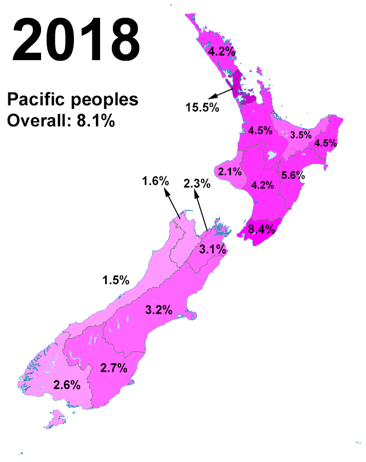
Pasifika New Zealanders (also called Pacific Peoples) are a pan-ethnic group of New Zealanders associated with, and descended from, the indigenous peoples of the Pacific Islands (also known as Pacific Islander#New Zealand, Pacific Islanders) outside New Zealand itself. They form the fourth-largest ethnic grouping in the country, after European New Zealanders, European descendants, indigenous Māori people, Māori, and Asian New Zealanders. Over 380,000 people identify as being of Pacific origin, representing 8% of the country's population, with the majority residing in Auckland. History Prior to the Second World War Pasifika in New Zealand numbered only a few hundred. Wide-scale Pasifika migration to New Zealand began in the 1950s and 1960s, typically from countries associated with the Commonwealth and the Realm of New Zealand, including Western Samoa (modern-day Samoa), the Cook Islands and Niue. In the 1970s, governments (both New Zealand Labour Party, Labour and New Zealand ... [...More Info...] [...Related Items...] OR: [Wikipedia] [Google] [Baidu] |
Chinese New Zealanders
Chinese New Zealanders (; ) or Sino-New Zealanders are New Zealanders of Chinese people, Chinese ancestry. The largest subset of Asian New Zealanders, many of the Chinese immigrants came from Mainland China, Hong Kong, Taiwan, or other countries that have large populations of Chinese emigration, Chinese diaspora. Today's Chinese New Zealand group is also composed of diasporic communities from Chinese Indonesian, Indonesia, Chinese Malaysian, Malaysia, Chinese Cambodian, Cambodia, Hoa people, Vietnam and Chinese Singaporean, Singapore. As of 2018, Chinese New Zealanders account for 4.9% of the population of New Zealand, and are the largest Asian ethnic group in New Zealand, accounting for 36.3% of Asian New Zealanders. In the 1860s gold rush immigrants from Guangdong arrived. Due to this historical influx, there is still a distinct Chinese community in Dunedin, whose mayor Peter Chin is of Chinese descent. However, most Chinese New Zealanders live in the North Island, and are o ... [...More Info...] [...Related Items...] OR: [Wikipedia] [Google] [Baidu] |
Pakuranga (New Zealand Electorate)
Pakuranga is a New Zealand Parliamentary electorate. It gave the Social Credit Party one of its few MPs when Neil Morrison held the seat from 1984 to 1987, but otherwise the electorate seat has been held by the National Party since 1972. Its current MP is Simeon Brown who has held the electorate since the 2017 general election. Population centres Pakuranga is one of 64 general electorates used in New Zealand general elections. It covers part of eastern Auckland around the eponymous suburb of Pakuranga. Other population centres include Farm Cove, Half Moon Bay, Bucklands Beach, parts of Highland Park and parts of Howick. The boundaries of the Pakuranga electorate were last adjusted in the 2007 redistribution. Initially, the Representation Commission proposed substantial changes, but after hearing objections mainly about Pakuranga, , and , the shape of the Pakuranga electorate reverted to almost the boundaries prior to the review. No boundary adjustments were undertaken i ... [...More Info...] [...Related Items...] OR: [Wikipedia] [Google] [Baidu] |
Botany Downs, New Zealand
Botany Downs is an eastern suburb of the city of Auckland, New Zealand. This residential area previously formed part of the East Tāmaki area. In terms of local-body administration, the suburb lies in the Howick ward, one of the thirteen administrative divisions of the Auckland Council. Geography Botany Downs is located in the central peninsula of East Auckland, between the Tāmaki River and Tāmaki Strait of the Hauraki Gulf. The suburb is south of Howick, New Zealand, Howick. Botany Creek runs west through the suburb to meet the Pakuranga Creek. The soil around Howick is primarily clay and sandstone. Botany Road is a major arterial road that runs north-south through Botany Downs, which intersects with Cascades Road to the south of the suburb. History Early history The Botany Downs area is part of the rohe of Ngāi Tai ki Tāmaki, who descend from the crew of the ''Tainui'' migratory waka, who visited the area around the year 1300. Ōwairoa is the traditional name us ... [...More Info...] [...Related Items...] OR: [Wikipedia] [Google] [Baidu] |
Dannemora, New Zealand
Dannemora is a suburb in Auckland, New Zealand. It is located in the east of the city, close to Pakuranga and Botany Downs, and in the Howick ward and local board area of Auckland Council. Geography Dannemora is an ill-defined area of East Auckland near Chapel Road and Kilkenny Drive, south of Shamrock Park. The area is close to the suburbs of Botany, East Tāmaki Heights and Flat Bush. Areas of Flat Bush such as Topland Drive are also known as Dannemora. The highest point in the area is Puke-i-Āki-Rangi, a 142-metre hill also known as Point View. History Early history The Dannemora area is part of the rohe of Ngāi Tai ki Tāmaki, who descend from the crew of the ''Tainui'' migratory waka, who visited the area around the year 1300. Puke-i-Āki-Rangi was a defended Ngāi Tai pā site. The name literally means "The Hill That Way Propelled Skyward". During the Musket Wars in the 1820s, Ngāi Tai Ki Tāmaki sought temporary refuge in the Waikato. In 1836, English mis ... [...More Info...] [...Related Items...] OR: [Wikipedia] [Google] [Baidu] |
East Tāmaki
East Tāmaki is a suburb of Auckland, New Zealand. It is a largely industrial area adjacent to a rapidly growing population. Prior to the 1960s it was largely a dairy farming area. A landmark is Smales Mountain which in 2010 has the remains of an old Pā, a stone field garden, an early church, and farm homestead. A newer landmark is the Fo Guang Shan Temple, Auckland, Fo Guang Shan Temple which was the largest Buddhist temple in New Zealand when it opened in 2007. History Te Puke o Tara (literally; ‘The Hill of Tara’); known also for a time as Smales Mount. Te Puke o Tara was the home of paramount chief Tara Te Irirangi of Ngāi Tai ki Tāmaki, Ngāi Tai iwi. One of East Tāmaki's prominent volcanic cones, and prior to European settlement in the area was the site of a scoria cone . Like most of Auckland, the East Tāmaki landscape is volcanic in origin and forms a part of what is known as the East Tāmaki volcanic field, with Te Puke o Tara and Mātanginui (Greenmount) ... [...More Info...] [...Related Items...] OR: [Wikipedia] [Google] [Baidu] |
Flat Bush
Flat Bush (also known as Ormiston or Flatbush) is a southeastern suburb in the city of Auckland, New Zealand. It has recently become one of the city's largest new planned towns after being developed as an urban area of Auckland for several decades. Located east of Ōtara, plans for substantial expansion began under the Manukau City Council — having bought 290 hectares in the area in 1996. As of 2023, substantial residential development means the area has grown to over 45,000 people, a similar population to Nelson, and includes a large shopping centre: Ormiston Town Centre. History Early history The Flat Bush area is part of the rohe of Ngāi Tai ki Tāmaki, who descend from the crew of the ''Tainui''komanawa waka, who visited the area around the year 1300. The traditional name for the wider forested area was , a name now essentially applied to the Hūnua Ranges. Ngāi Tai centred life along the coasts between the Tāmaki River and Wairo River, settling at locations ... [...More Info...] [...Related Items...] OR: [Wikipedia] [Google] [Baidu] |
Auckland City
Auckland City () was a territorial authority area with city status covering the central isthmus of the urban area of Auckland, New Zealand. It was governed by the Auckland City Council from 1989 to 2010, and as a territory within the wider Auckland Region, was also governed by Auckland Regional Council. Auckland City was disestablished as a local authority on 1 November 2010, when Auckland City Council was amalgamated with other councils of the Auckland Region into the new Auckland Council. At the time of its disestablishment, the city had a resident population of around 450,000. The Auckland City included the Auckland CBD – a major financial and commercial centre – the surrounding suburbs, and Hauraki Gulf islands such as Waiheke and Great Barrier Island. Geography The mainland part of Auckland City occupied the Auckland isthmus, also known as the Tāmaki isthmus. The Waitematā Harbour, which opens to the Hauraki Gulf, separated North Shore City from the isthmus. T ... [...More Info...] [...Related Items...] OR: [Wikipedia] [Google] [Baidu] |
Manukau East
Manukau East was a New Zealand parliamentary electorate that returned one member of parliament to the House of Representatives. It was first formed for the . Between the and the 2020 electorate adjustment it was held by Jenny Salesa, a member of the Labour Party, who also won the replacement Panmure-Ōtāhuhu seat in the . Population centres In 2007, large changes were made to the Manukau East electorate. Its northern boundary extended past the Tamaki River to almost as far as Sylvia Park Rd to incorporate Middlemore, Ōtāhuhu and Westfield. Its eastern boundary shifted west to East Tamaki Rd resulting in East Tamaki and Botany Downs being included in the new Botany electorate. Most of Ōtara and Papatoetoe Papatoetoe is a suburb in Auckland, New Zealand. It is the largest suburb in Auckland by population and is located to the northwest of Manukau, Manukau Central, and southeast of Auckland CBD. Papatoetoe was traditionally an important area fo ... West are now als ... [...More Info...] [...Related Items...] OR: [Wikipedia] [Google] [Baidu] |


