|
Avannaa
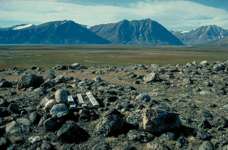
Avannaa, originally Nordgrønland ("North Greenland"), was one of the three counties () of Greenland, which existed until 31 December 2008. The county seat was Qaanaaq, the main settlement. It was one of the least-densely populated administrative divisions in the world, with 843 people living in 106,700 km2 of ice-free land, a density of 0.0079 people per square kilometre. The total land area, including the land covered by the ice cap, is over 500,000 km2. North Greenland has a higher portion of ice-free land than most other areas of the country, because much of the extreme north, such as Peary Land, is largely ice-free due to its low precipitation."The CIA World Factbook 2008" Central Intelligence Agency, Skyhorse Publishing, 2007, , p. 253 The county was also sometimes known as ''Avannaarsua'' or ''Avanersuaq''. Former local divisions *Qaanaaq municipality, created 1 January 1963 *Pituffik Space Base ( Pituffik) (unincorporated), an enclave surrounded by Qaanaaq ... [...More Info...] [...Related Items...] OR: [Wikipedia] [Google] [Baidu] |
Administrative Divisions Of Greenland
Greenland is divided into five municipalities and two unincorporated areas. The municipalities are Avannaata, Kujalleq, Qeqertalik, Qeqqata, and Sermersooq.Statistics Greenland''Greenland in Figures, 2014''/ref> Northeast Greenland National Park is a huge unincorporated area that is outside the municipalities and larger than any of them. Pituffik Space Base is a small unincorporated enclave surrounded by the Avannaata municipality and administered by the United States Space Force. Municipalities History Greenland was divided into two inspectorates in 1782 – North Greenland, with its capital at Godhavn (now called Qeqertarsuaq), and South Greenland, with its capital at Godthaab (now Nuuk). These were directed by inspectors until 1924, then by governors. The two divisions were amalgamated in 1950 and the administration centralized at Godthaab. In 1953 a new constitution of Denmark promoted Greenland to full membership in the Danish state, with all of its inhabitant ... [...More Info...] [...Related Items...] OR: [Wikipedia] [Google] [Baidu] |
Greenland North
Greenland is an autonomous territory in the Danish Realm, Kingdom of Denmark. It is by far the largest geographically of three constituent parts of the kingdom; the other two are metropolitan Denmark and the Faroe Islands. Citizens of Greenland are full Danish nationality law, citizens of Denmark and European Union citizenship, of the European Union. Greenland is one of the Special territories of members of the European Economic Area#Overseas countries and territories, Overseas Countries and Territories of the European Union and is part of the Council of Europe. It is the List of islands by area, world's largest island, and lies between the Arctic Ocean, Arctic and Atlantic oceans, east of the Arctic Archipelago, Canadian Arctic Archipelago. It is the location of the northernmost point of land in the world; Kaffeklubben Island off the northern coast is the world's Northernmost point of land, northernmost undisputed point of land—Cape Morris Jesup on the mainland was thought to ... [...More Info...] [...Related Items...] OR: [Wikipedia] [Google] [Baidu] |
Qaanaaq
Qaanaaq (), formerly known as New Thule, is the main town in the northern part of the Avannaata municipality in northwestern Greenland. The town has a population of 646 as of 2020. The population was forcibly relocated from its former, traditional home, which was expropriated for the construction of a United States Air Force base (Thule Air Base, now Pituffik Space Base) in 1953. The inhabitants of Qaanaaq speak the local Inuktun language and many also speak Kalaallisut and Danish. Qaanaaq is one of the northernmost towns in the world. Within Greenland, it is the northernmost major town and the third northernmost public settlement, after nearby Qeqertat and Siorapaluk. Geography Qaanaaq is located in the northern entrance of the Inglefield Fjord. The village of Qeqertat is located in the Harvard Islands, near the head of the fjord. History The Qaanaaq area in northern Greenland was first settled around 2000 BCE by Paleo-Eskimos migrating from the Canadian Arctic. Th ... [...More Info...] [...Related Items...] OR: [Wikipedia] [Google] [Baidu] |
Thule
Thule ( ; also spelled as ''Thylē'') is the most northerly location mentioned in ancient Greek and Roman literature and cartography. First written of by the Greek explorer Pytheas of Massalia (modern-day Marseille, France) in about 320 BC, it was often described by later writers as an island north of Ireland or Britain. Modern interpretations have included Orkney, Shetland, Northern Scotland, the Faroe Islands, and Iceland. Other potential locations are the island of Saaremaa (Ösel) in Estonia, or the Norwegian island of Smøla.Andreas Kleineberg, Christian Marx, Eberhard Knobloch und Dieter Lelgemann: ''Germania und die Insel Thule. Die Entschlüsselung von Ptolemaios' "Atlas der Oikumene".'' Wissenschaftliche Buchgesellschaft, Darmstadt 2010. In classical and medieval literature, ''ultima Thule'' (Latin "farthest Thule") acquired a metaphorical meaning of any distant place located beyond the "borders of the known world". By the Late Middle Ages and the early modern per ... [...More Info...] [...Related Items...] OR: [Wikipedia] [Google] [Baidu] |
Northeast Greenland National Park
Northeast Greenland National Park (, ) is the world's largest national park and the 10th largest protected area (the only larger protected areas consist mostly of sea). Established in 1974, the Northeast Greenland national park expanded to its present size in 1988. It protects of the interior and northeastern coast of Greenland and is larger than the area of Tanzania, but smaller than that of Egypt. This means that the national park is bigger than 166 of the world's 195 countries. It was the first national park to be created in the Kingdom of Denmark and remains Greenland's only national park. It is the northernmost national park in the world and the second-largest by area of any second-level subdivision of any country in the world, trailing only the Qikiqtaaluk Region in Nunavut, Canada. Geography The park shares borders, largely laid out as straight lines, with the Sermersooq municipality in the south and with the Avannaata municipality in the west, partly along the 45° ... [...More Info...] [...Related Items...] OR: [Wikipedia] [Google] [Baidu] |
North Greenland
The Northern Inspectorate of Greenland (), also known as North Greenland, was a Danish inspectorate on Greenland consisting of the trading centers and missionary stations along the northwest coast of the island. History West Greenland was divided into the Northern Inspectorate and the Southern Inspectorate ( South Greenland) from 1782. The boundary between the two ran at around 68°N latitude. The Northern Inspectorate's southernmost town was Egedesminde, now Aasiaat, north of Holstensborg, now Sisimiut, which was the northernmost town of South Greenland. The Northern Inspectorate extended northwards up to and including Upernavik, or, according to Bell (1831), to 78°N Bell, James (1831). ''A System of Geography, Popular and Scientific''. Vol. 5p. 281 to enclose Thule. The capital was at Godhavn (modern Qeqertarsuaq). In 1911, as the administration of the colony was removed from the Royal Greenland Trading Department The Royal Greenland Trading Department (, KGH) was ... [...More Info...] [...Related Items...] OR: [Wikipedia] [Google] [Baidu] |
Pituffik Space Base
Pituffik Space Base ( ; ; ), formerly Thule Air Base (), is a United States Space Force base located on the northwest coast of Greenland in the Kingdom of Denmark under a defense agreement between Denmark and the United States. 150 United States guardians serve there, after the United States significantly reduced its presence from 6000 personnel during the Cold War. Denmark was a founding member of NATO in 1949, and the 1951 Greenland Defense Agreement allowed the United States to operate the base under a NATO framework, as long as both Denmark and the United States remain NATO members. Under the agreement, the Flag of Denmark, Danish national flag must be flown at the base to recognize that the base is on Danish territory, but the United States is allowed to fly its own flag alongside the Danish flag on the facilities it operates. It is the northernmost installation of the U.S. Armed Forces, north of the Arctic Circle and from the North Pole. Pituffik's Arctic environment in ... [...More Info...] [...Related Items...] OR: [Wikipedia] [Google] [Baidu] |
Pituffik
Pituffik is a former Inughuit settlement in North Star Bay, near Mount Dundas at the eastern end of Bylot Sound in northern Greenland. The area is now occupied by the U.S. Pituffik Space Base, formerly Thule Air Base. The Inughuit inhabitants were relocated to the present-day town of Qaanaaq. The relocation and the fallout from the 1968 Thule Air Base B-52 crash in the vicinity are a contentious issue in Greenland's relations with Denmark and the United States. Exploration Pituffik was a hunting village of the Inughuit, the northern Greenlandic Inuit. The Qaanaaq region of northern Greenland in which it is located was inhabited for several thousand years, first settled 4,500 years ago by Paleo-Eskimo peoples migrating from the Canadian Arctic. The area was explored by Commander James Saunders of the Royal Navy while wintering on HMS ''North Star'' in 1849–50 after being trapped by ice in the sound. [...More Info...] [...Related Items...] OR: [Wikipedia] [Google] [Baidu] |
Peary Land
Peary Land is a peninsula in northern Greenland, extending into the Arctic Ocean. It reaches from Victoria Fjord in the west to Independence Fjord in the south and southeast, and to the Arctic Ocean in the north, with Cape Morris Jesup, the northernmost point of Greenland's mainland, and Cape Bridgman in the northeast. History Ancient settlements Peary Land was historically inhabited by three separate cultures, during which times the climate was milder than presently. It contains the northernmost ruins on earth, an archaeological site found in 2023. *Independence I culture, Paleo-Eskimo (around 2000 BC, oldest remains dating from 2400 BC) *Independence II culture, Paleo-Eskimo (800 BC to 200 BC) * Thule culture (ancestral to the modern Inuit, around AD 1300) Peary's explorations The area is named after Robert E. Peary, who first explored it during his expedition of 1891 to 1892. Originally, Peary Land was believed to be an island, separated from the main island by the ... [...More Info...] [...Related Items...] OR: [Wikipedia] [Google] [Baidu] |
Prawn
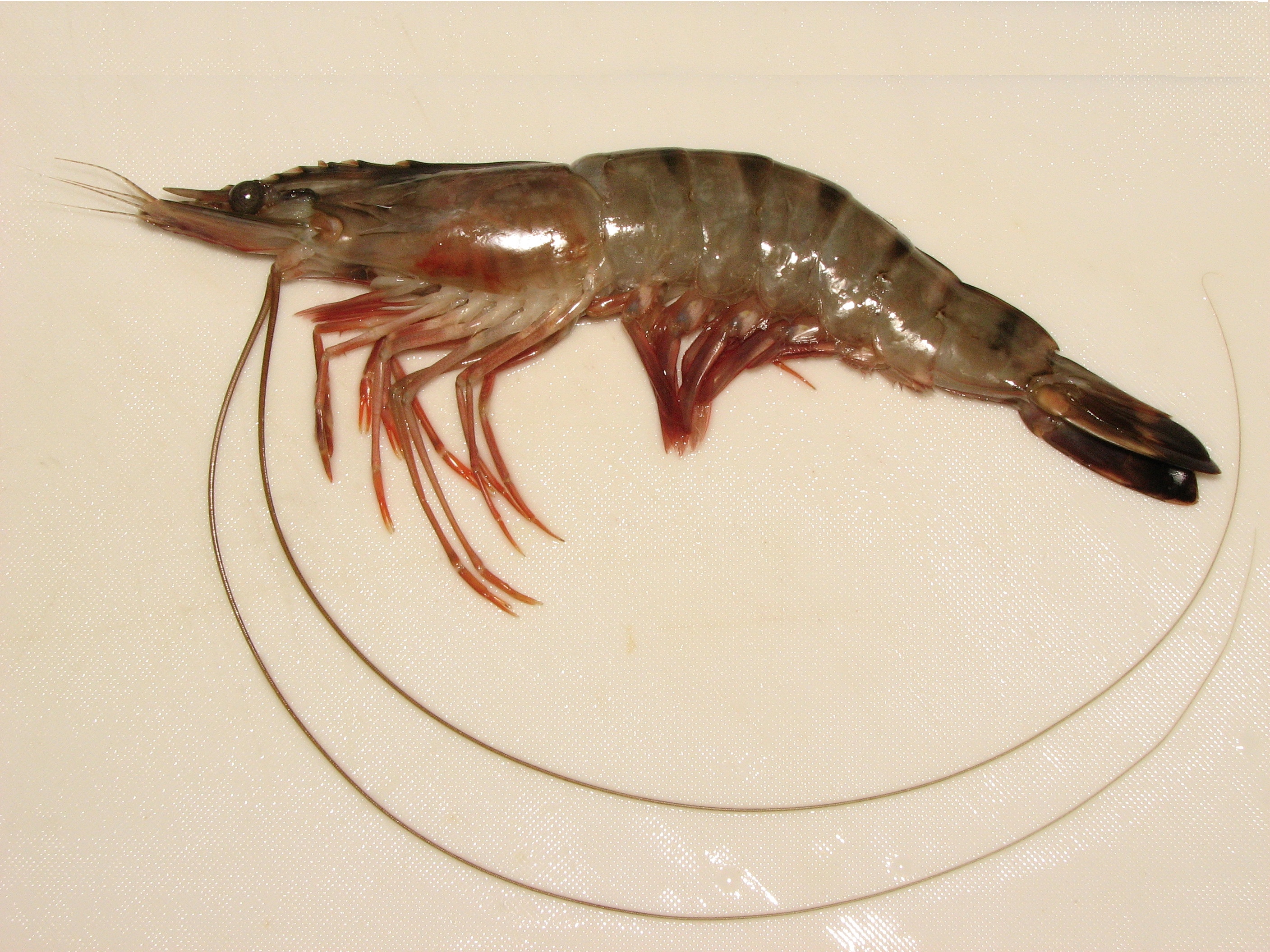
Prawn is a common name for small aquatic crustaceans with an exoskeleton An exoskeleton () . is a skeleton that is on the exterior of an animal in the form of hardened integument, which both supports the body's shape and protects the internal organs, in contrast to an internal endoskeleton (e.g. human skeleton, that ... and ten legs (members of the order of decapods), some of which are edible. The term ''prawn''Mortenson, Philip B (2010''This is not a weasel: a close look at nature's most confusing terms''Pages 106–109, John Wiley & Sons. . is used particularly in the United Kingdom, Ireland, and Commonwealth nations, for large swimming crustaceans or shrimp, especially those with commercial significance in the fishing industry. Shrimp in this category often belong to the suborder Dendrobranchiata. In North America, the term is used less frequently, typically for freshwater shrimp. The terms ''shrimp'' and ''prawn'' themselves lack scientific standing. Over the years, ... [...More Info...] [...Related Items...] OR: [Wikipedia] [Google] [Baidu] |


