|
Atlantic Sawtail Catshark
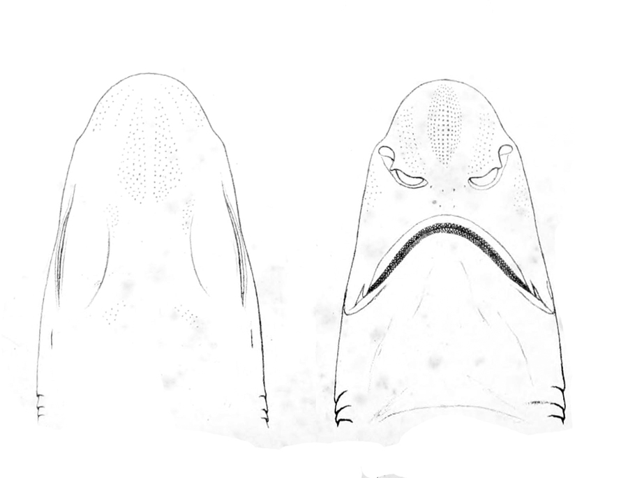
The Atlantic sawtail catshark (''Galeus atlanticus'') is a little-known species of catshark, part of the family Scyliorhinidae, found in a small area of the northeastern Atlantic Ocean, centered on the Strait of Gibraltar and the Alborán Sea. It is found on or close to the bottom over the continental slope, mostly at depths of . This shark closely resembles, and was once thought to be the same species as, the blackmouth catshark (''G. melastomus''); both are slender with a series of dark saddles and blotches along the back and tail, and a prominent crest of enlarged dermal denticles along the dorsal edge of the caudal fin. It differs subtly from ''G. melastomus'' in characters including snout length, caudal peduncle depth, and the color of the furrows at the corner of its mouth. Reproduction in the Atlantic sawtail catshark is oviparous, with females carrying multiple maturing eggs at once. Mating and spawning occur year-round. This species is caught incidentally by commercial ... [...More Info...] [...Related Items...] OR: [Wikipedia] [Google] [Baidu] |
The IUCN Red List Of Threatened Species
The International Union for Conservation of Nature (IUCN) Red List of Threatened Species, also known as the IUCN Red List or Red Data Book, founded in 1964, is the world's most comprehensive inventory of the global conservation status of biological species. It uses a set of precise criteria to evaluate the extinction risk of thousands of species and subspecies. These criteria are relevant to all species and all regions of the world. With its strong scientific base, the IUCN Red List is recognized as the most authoritative guide to the status of biological diversity. A series of Regional Red Lists are produced by countries or organizations, which assess the risk of extinction to species within a political management unit. The aim of the IUCN Red List is to convey the urgency of conservation issues to the public and policy makers, as well as help the international community to reduce species extinction. According to IUCN the formally stated goals of the Red List are to provide ... [...More Info...] [...Related Items...] OR: [Wikipedia] [Google] [Baidu] |
Bycatch
Bycatch (or by-catch), in the fishing industry, is a fish or other marine species that is caught unintentionally while fishing for specific species or sizes of wildlife. Bycatch is either the wrong species, the wrong sex, or is undersized or juveniles of the target species. The term "bycatch" is also sometimes used for untargeted catch in other forms of animal harvesting or collecting. Non- marine species ( freshwater fish not saltwater fish) that are caught (either intentionally or unintentionally) but regarded as generally "undesirable" are referred to as " rough fish" (mainly US) and "coarse fish" (mainly UK). In 1997, the Organisation for Economic Co-operation and Development (OECD) defined bycatch as "total fishing mortality, excluding that accounted directly by the retained catch of target species". Bycatch contributes to fishery decline and is a mechanism of overfishing for unintentional catch. The average annual bycatch rate of pinnipeds and cetaceans in the US from 199 ... [...More Info...] [...Related Items...] OR: [Wikipedia] [Google] [Baidu] |
Mauritania
Mauritania (; ar, موريتانيا, ', french: Mauritanie; Berber languages, Berber: ''Agawej'' or ''Cengit''; Pulaar language, Pulaar: ''Moritani''; Wolof language, Wolof: ''Gànnaar''; Soninke language, Soninke:), officially the Islamic Republic of Mauritania ( ar, الجمهورية الإسلامية الموريتانية), is a sovereign country in West Africa. It is bordered by the Atlantic Ocean to the west, Western Sahara to Mauritania–Western Sahara border, the north and northwest, Algeria to Algeria–Mauritania border, the northeast, Mali to Mali–Mauritania border, the east and southeast, and Senegal to Mauritania–Senegal border, the southwest. Mauritania is the 11th-largest country in Africa and the 28th-largest in the world, and 90% of its territory is situated in the Sahara. Most of its population of 4.4 million lives in the temperate south of the country, with roughly one-third concentrated in the Capital city, capital and largest city, Nouakchott, loca ... [...More Info...] [...Related Items...] OR: [Wikipedia] [Google] [Baidu] |
Isla De Alborán
Alboran Island ( es, Isla de Alborán) is a small islet of Spain (province of Almería) in the Alboran Sea, part of the western Mediterranean Sea, about north of the Moroccan coast and from the Spanish mainland. The main buildings are an automated lighthouse built in the 19th century, a small cemetery, and a harbor. Description The island is a flat platform about above sea level and about in area. off the northeastern end of the island is the small ''islote de La Nube'' (literally, islet of the cloud). Natural history Alboran has a volcanic origin, located in an important seismic zone where the African plate collides with the Eurasian plate. In 1899 a new igneous rock was discovered on Alboran, with the name of alboranite, in honor of the island. The islet has been recognised as an Important Bird Area (IBA) by BirdLife International because it supports a breeding population of Audouin's gulls, as well as various species of passerines on migration. The wall-rock ... [...More Info...] [...Related Items...] OR: [Wikipedia] [Google] [Baidu] |
Spain
, image_flag = Bandera de España.svg , image_coat = Escudo de España (mazonado).svg , national_motto = '' Plus ultra'' ( Latin)(English: "Further Beyond") , national_anthem = (English: "Royal March") , image_map = , map_caption = , image_map2 = , capital = Madrid , coordinates = , largest_city = Madrid , languages_type = Official language , languages = Spanish , ethnic_groups = , ethnic_groups_year = , ethnic_groups_ref = , religion = , religion_ref = , religion_year = 2020 , demonym = , government_type = Unitary parliamentary constitutional monarchy , leader_title1 = Monarch , leader_name1 = Felipe VI , leader_title2 = Prime Minister , leader_name2 = Pedro Sánchez , legislature = ... [...More Info...] [...Related Items...] OR: [Wikipedia] [Google] [Baidu] |
Cabo De Gata
Cabo de Gata is a cape located in Níjar, Almería in the south of Spain, one of the biggest capes. It is the driest place in the Iberian Peninsula (150-170 mm average precipitation, being the lowest 52 mm in 1981). However, the area that it occupies is not considered a desert, even though there is one nearby: the Tabernas Desert, located 30 km in a northwest direction. The lowest temperature registered in Cabo de Gata was 0.1 °C. San José, Las Negras, Agua Amarga, Isleta del Moro, Rodalquilar, San Miguel, Almadraba de Moteleva, Fernán Pérez, Las Hortichuelas, Pozo de los Frailes, Los Escullos, Níjar and Carboneras are towns found in Cabo de Gata. The lighthouse is a famous landmark. On 26 March 2008 it was declared Parque Natural. References External links * {{commons-inline Geography of the Province of Almería Gata Davionte Ganter, known professionally as GaTa, is an American rapper and actor known for his role in the FXX TV series ''Dave'' ... [...More Info...] [...Related Items...] OR: [Wikipedia] [Google] [Baidu] |
Portugal
Portugal, officially the Portuguese Republic, In recognized minority languages of Portugal: :* mwl, República Pertuesa is a country located on the Iberian Peninsula, in Southwestern Europe, and whose territory also includes the Macaronesian archipelagos of the Azores and Madeira. It features the westernmost point in continental Europe, its mainland west and south border with the North Atlantic Ocean and in the north and east, the Portugal-Spain border, constitutes the longest uninterrupted border-line in the European Union. Its archipelagos form two autonomous regions with their own regional governments. On the mainland, Alentejo region occupies the biggest area but is one of the least densely populated regions of Europe. Lisbon is the capital and largest city by population, being also the main spot for tourists alongside Porto, the Algarve and Madeira. One of the oldest countries in Europe, its territory has been continuously settled and fought over since prehistoric tim ... [...More Info...] [...Related Items...] OR: [Wikipedia] [Google] [Baidu] |
Cape St
A cape is a clothing accessory or a sleeveless outer garment which drapes the wearer's back, arms, and chest, and connects at the neck. History Capes were common in medieval Europe, especially when combined with a hood in the chaperon. They have had periodic returns to fashion - for example, in nineteenth-century Europe. Roman Catholic clergy wear a type of cape known as a ferraiolo, which is worn for formal events outside a ritualistic context. The cope is a liturgical vestment in the form of a cape. Capes are often highly decorated with elaborate embroidery. Capes remain in regular use as rainwear in various military units and police forces, in France for example. A gas cape was a voluminous military garment designed to give rain protection to someone wearing the bulky gas masks used in twentieth-century wars. Rich noblemen and elite warriors of the Aztec Empire would wear a tilmàtli; a Mesoamerican cloak/cape used as a symbol of their upper status. Cloth and clot ... [...More Info...] [...Related Items...] OR: [Wikipedia] [Google] [Baidu] |
Mitochondrial DNA
Mitochondrial DNA (mtDNA or mDNA) is the DNA located in mitochondria, cellular organelles within eukaryotic cells that convert chemical energy from food into a form that cells can use, such as adenosine triphosphate (ATP). Mitochondrial DNA is only a small portion of the DNA in a eukaryotic cell; most of the DNA can be found in the cell nucleus and, in plants and algae, also in plastids such as chloroplasts. Human mitochondrial DNA was the first significant part of the human genome to be sequenced. This sequencing revealed that the human mtDNA includes 16,569 base pairs and encodes 13 proteins. Since animal mtDNA evolves faster than nuclear genetic markers, it represents a mainstay of phylogenetics and evolutionary biology. It also permits an examination of the relatedness of populations, and so has become important in anthropology and biogeography. Origin Nuclear and mitochondrial DNA are thought to be of separate evolutionary origin, with the mtDNA being deri ... [...More Info...] [...Related Items...] OR: [Wikipedia] [Google] [Baidu] |
Morphometric
Morphometrics (from Greek μορϕή ''morphe'', "shape, form", and -μετρία ''metria'', "measurement") or morphometry refers to the quantitative analysis of ''form'', a concept that encompasses size and shape. Morphometric analyses are commonly performed on organisms, and are useful in analyzing their fossil record, the impact of mutations on shape, developmental changes in form, covariances between ecological factors and shape, as well for estimating quantitative-genetic parameters of shape. Morphometrics can be used to quantify a trait of evolutionary significance, and by detecting changes in the shape, deduce something of their ontogeny, function or evolutionary relationships. A major objective of morphometrics is to statistically test hypotheses about the factors that affect shape. "Morphometrics", in the broader sense, is also used to precisely locate certain areas of organs such as the brain, and in describing the shapes of other things. Forms Three general appro ... [...More Info...] [...Related Items...] OR: [Wikipedia] [Google] [Baidu] |
Cape Spartel
Cape Spartel ( ar, رأس سبارطيل; french: Cap Spartel; ary, أشبرتال) is a promontory in Morocco about above sea level at the entrance to the Strait of Gibraltar, 12 km West of Tangier. Below the cape are the Caves of Hercules. Etymology According to Mohamed Chafik, the name of this location is derived from Latin ''spartium'', which is the name of a plant genus (Spanish broom). Description Cape Spartel is frequently but incorrectly referred to as the northernmost point of Africa, which is instead Ras ben Sakka, Tunisia. It is the most North Western point of mainland Africa. The cape rises to a height of 326 m. at the top of Jebel Quebir where there is a tower. There is another tower nearer to the end of the cape which serves as a lighthouse. Below the cape are the Caves of Hercules. These are open to the public and they are accessible from Robinson Plage. The caves have shown evidence of Neolithic occupation. Before they were a tourist attraction they were ... [...More Info...] [...Related Items...] OR: [Wikipedia] [Google] [Baidu] |


