|
Aran Islands
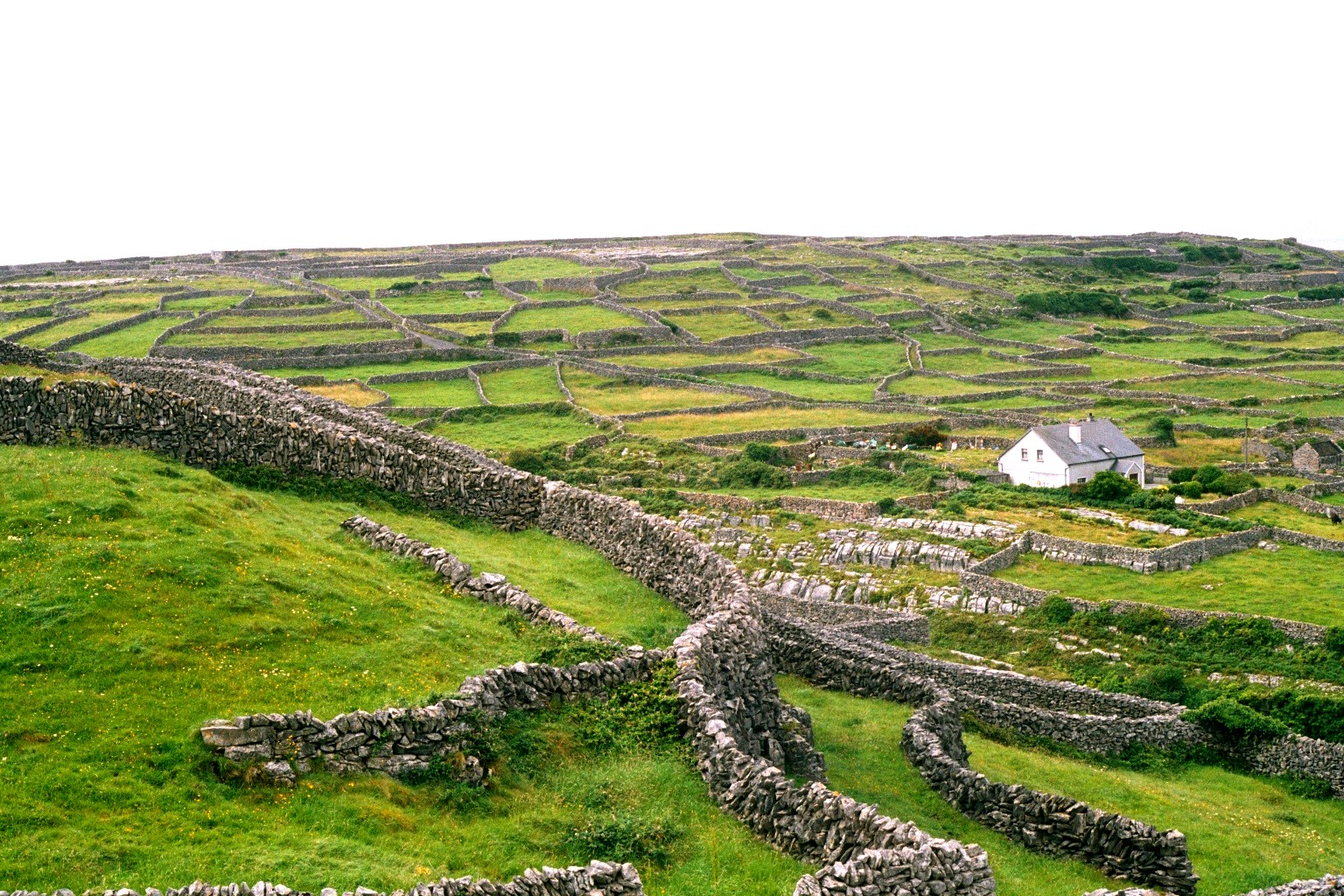
The Aran Islands ( ; , ) or The Arans ( ) are a group of three islands at the mouth of Galway Bay, off the west coast of Republic of Ireland, Ireland, with a total area around . They constitute the historic barony (Ireland), barony of Aran in County Galway. From west to east, the islands are: Inishmore ( / ), which is the largest; Inishmaan (), the second-largest; and Inisheer (), the smallest. There are also several islets. The population of 1,347 (as of 2022) primarily speak Irish language, Irish, making the islands a part of the Gaeltacht. Most islanders are also fluent or proficient in Hiberno-English, English. The population has steadily declined from around 3,500 in 1841. Location and access The approaches to the bay between the Aran Islands and the mainland are: * North Sound''An Súnda ó Thuaidh'' (more accurately ''Bealach Locha Lurgan'') lies between Inishmore and Lettermullen, County Galway. * Gregory's Sound''Súnda Ghríoghóra'' (formerly known as ''Bealach na ... [...More Info...] [...Related Items...] OR: [Wikipedia] [Google] [Baidu] |
Inishmore
Inishmore ( , or ) is the largest of the Aran Islands in Galway Bay, off the west coast of Ireland. With an area of and a population of 820 (as of 2016), it is the second-largest island off the Irish coast (after Achill) and most populous of the Aran Islands. The island is in the Irish-speaking Gaeltacht and has a strong Irish culture. Much of the island is karst landscape and it has a wealth of ancient and medieval sites including Dún Aonghasa, described as "the most magnificent barbaric monument in Europe" by George Petrie. The island is a civil parish of the same name. Name Before the 20th century, the island was usually called or , which is thought to mean 'kidney-shaped' or 'ridge'. It was anglicized as Aran, Aran More, or Great Aran. This has caused some confusion with Arranmore, County Donegal, which has the same Irish name. The name "Inishmore" was "apparently concocted by the Ordnance Survey for its map of 1839" as an Anglicization of ('big island'), as th ... [...More Info...] [...Related Items...] OR: [Wikipedia] [Google] [Baidu] |
Inishmaan
Inishmaan ( ; , the official name, formerly spelled , meaning "middle island") is the middle of the three main Aran Islands in Galway Bay, off the west coast of Republic of Ireland, Ireland. It is part of County Galway in the province of Connacht. Inishmaan has a population of about 184 (census 2022), making it the least populous of the Aran Islands. It is one of the most important strongholds of traditional Irish culture. The island is predominantly Irish language, Irish-speaking and part of the Gaeltacht, though all inhabitants have knowledge of English. Geology and geography The island is an extension of The Burren. The terrain of the island is composed of limestone pavements with crisscrossing cracks known as "grykes", leaving isolated rocks called "clints". The limestones date from the Visean period (Lower Carboniferous), formed as sediments in a tropical sea about 350 million years ago, and compressed into horizontal strata with fossil corals, crinoids, sea urchins, a ... [...More Info...] [...Related Items...] OR: [Wikipedia] [Google] [Baidu] |
Inisheer
Inisheer ( , or ) is the smallest and most easterly of the three Aran Islands in Galway Bay, Ireland. With 343 residents as of the 2022 census, it is second-most populous of the Arans. Caomhán of Inis Oírr is the island's patron saint. There are five small settlements: Baile Thiar, Chapeltown (Baile an tSéipéil), Castle Village (Baile an Chaisleáin), Baile an Fhormna and Baile an Lorgain. The island is in a civil parish of the same name. Name The island was originally called ''Árainn Airthir'', and later ''Inis Oirthir'', which are thought to mean "eastern Aran" and "eastern island" respectively. (see scanned records) The second element is also found in the names Inishsirrer and Orior. According to Séamas Ó Murchú, the current official name, , was brought into use by the Ordnance Survey Ireland. He says it may be a compromise between and the traditional local name . Geology and geography The island is geologically an extension of The Burren. The terrain of ... [...More Info...] [...Related Items...] OR: [Wikipedia] [Google] [Baidu] |
Inverin
Inverin (, meaning "mouth of the river") is a Gaeltacht village between Baile na hAbhann and Minna in County Galway, Ireland. There are Irish-language summer colleges in the area, most notably Coláiste Lurgan and Coláiste Uí Chadhain. The village is on the R336 road and is served by the 424 Bus Éireann route from Galway. ''Cumann Forbartha Chois Fharraige'' is a local development association founded in 1966. The Gaelic Athletic Association club, ''Cumann Lúthchleas Gael Mhícheál Breathnach'', holds a Gaelic football tournament every year on Saint Stephen's Day. An Irish language book club in the village, Club Leabhar Chois Fharraige, meets monthly. The airline Aer Arann Islands is headquartered at Connemara Airport near the village. " |
Gaelicisation
Gaelicisation, or Gaelicization, is the act or process of making something Gaels, Gaelic or gaining characteristics of the ''Gaels'', a sub-branch of Celticisation. The Gaels are an ethno-linguistic group, traditionally viewed as having spread from Ireland to Scotland and the Isle of Man. ''Gaelic'', as a linguistic term, refers to the Goidelic languages, Gaelic languages but can also refer to the transmission of any other Gaelic cultural feature such as social norms and customary law, customs, music and sport. It is often referred to as a part of Celts (modern), Celtic identity since Ireland, Scotland and the Isle of Man are all considered Celtic nations, and the Gaelic languages are considered a sub-group of the Celtic languages. Early history Examples of ethnic groups that have gone through a period of Gaelicisation in history include the Norse-Gaels, the Picts, the Kingdom of Strathclyde, Britons of south-western Scotland, the Scoto-Normans, and the Hiberno-Normans, Modern e ... [...More Info...] [...Related Items...] OR: [Wikipedia] [Google] [Baidu] |
Islet
An islet ( ) is generally a small island. Definitions vary, and are not precise, but some suggest that an islet is a very small, often unnamed, island with little or no vegetation to support human habitation. It may be made of rock, sand and/or hard coral; may be permanent or tidal (i.e. surfaced reef or seamount); and may exist in the sea, lakes, rivers or any other sizeable bodies of water. Definition As suggested by its origin ''islette'', an Old French diminutive of "isle", use of the term implies small size, but little attention is given to drawing an upper limit on its applicability. The World Landforms website says, "An islet landform is generally considered to be a rock or small island that has little vegetation and cannot sustain human habitation", and further that size may vary from a few square feet to several square miles, with no specific rule pertaining to size. Other terms * Ait (/eɪt/, like eight) or eyot (/aɪ(ə)t, eɪt/), a small island. It is espe ... [...More Info...] [...Related Items...] OR: [Wikipedia] [Google] [Baidu] |
Gaeltacht
A ( , , ) is a district of Ireland, either individually or collectively, where the Irish government recognises that the Irish language is the predominant vernacular, or language of the home. The districts were first officially recognised during the 1920s in the early years of the Irish Free State, following the Gaelic revival, as part of a government policy aimed at restoring the Irish language. The is threatened by serious language decline. Research published in 2015 showed that Irish is spoken on a daily basis by two-thirds or more of the population in only 21 of the 155 electoral divisions in the . Daily language use by two-thirds or more of the population is regarded by some academics as a tipping point for language survival.RTÉ News Report of Friday 29 May 2015 History In 1926, the official was designated as a result of the report of the first Gaeltacht Commission ''Coimisiún na Gaeltachta''. The exact boundaries were not defined. At the time, an area was clas ... [...More Info...] [...Related Items...] OR: [Wikipedia] [Google] [Baidu] |
Rossaveal
Rossaveal or Rossaveel ( or ) is a Gaeltacht village and townland in the Connemara district of County Galway in the west of Ireland. It is the main ferry port for the Aran Islands in Galway Bay. It is about from Galway city. The village is located in the Barony of Moycullen. The Irish name means "peninsula (or wood) of the whale (or sea monster)". It may also mean "the wooded hill". The village is the home of the centre under , an Irish language immersion summer camp for teenagers. It is served by Bus Éireann route 424 from Galway. A ferry service to the Aran Islands runs from the harbour. Irish language As of the 2011 census, there were 208 people living in townland, with 73% of these speaking Irish language, Irish daily. See also *List of towns and villages in the Republic of Ireland References Gaeltacht places in County Galway Towns and villages in Connemara Gaeltacht towns and villages {{Galway-geo-stub ... [...More Info...] [...Related Items...] OR: [Wikipedia] [Google] [Baidu] |
Doolin
Doolin () is a coastal village in County Clare, Ireland, on the Atlantic coast. It is southwest of the spa town of Lisdoonvarna and 4 miles from the Cliffs of Moher. It is a noted centre of traditional Irish music, which is played nightly in its pubs, making it a popular tourist destination. There are numerous nearby archaeological sites, many dating to the Iron Age and earlier. Doonagore Castle and Ballinalacken Castle are also in the area. The area was officially classified as part of the West Clare Gaeltacht (an Irish-speaking community) prior to the 1950s, and maintains a connection with Irish-speaking areas - including via its maritime connection with the Aran Islands. Amenities and tourism Layout The village of Doolin does not have a defined centre, comprising a number of "scattered" sections: * "The Harbour" is the departing point for boat trips to the Aran Islands and the Cliffs of Moher. There is also a campsite nearby * "Fisher Street" has O'Connor's Pub and se ... [...More Info...] [...Related Items...] OR: [Wikipedia] [Google] [Baidu] |
Galway Bay
Galway Bay ( Irish: ''Loch Lurgain'' or ''Cuan na Gaillimhe'') is a bay on the west coast of Ireland, between County Galway in the province of Connacht to the north and the Burren in County Clare in the province of Munster to the south; Galway city is on the northeast side. The bay is about long and from to in breadth. The Aran Islands (''Oileáin Árann'') are to the west across the entrance and there are numerous small islands within the bay. To the west of Galway, the rocks are granite but to the south they are limestone. The approaches to the bay between the Aran Islands and the mainland are as follows: * the North Sound (''An Súnda ó Thuaidh'') lies between Inishmore and Leitir Mealláin in Connemara; known as ''Bealach Locha Lurgan'' in Irish. * Gregory's Sound (''Súnda Ghríoghóra'') lies between Inishmore and Inishmaan; known as ''Bealach na h-Áite'' in Irish. * Foul Sound (''An Súnda Salach'') lies between Inishmaan and Inisheer; known as ''Bealach na Fearb ... [...More Info...] [...Related Items...] OR: [Wikipedia] [Google] [Baidu] |
Ulster
Ulster (; or ; or ''Ulster'') is one of the four traditional or historic provinces of Ireland, Irish provinces. It is made up of nine Counties of Ireland, counties: six of these constitute Northern Ireland (a part of the United Kingdom); the remaining three are in the Republic of Ireland. It is the second-largest (after Munster) and second-most populous (after Leinster) of Ireland's four traditional provinces, with Belfast being its biggest city. Unlike the other provinces, Ulster has a high percentage of Protestantism in Ireland, Protestants, making up almost half of its population. English is the main language and Ulster English the main dialect. A minority also speak Irish, and there are (Irish-speaking regions) in County Donegal which is home to a quarter of the total Gaeltacht population of the Republic of Ireland. There are also large Irish-speaking networks in southern County Londonderry and in the Gaeltacht Quarter, Belfast. Ulster Scots dialect, Ulster-Scots is al ... [...More Info...] [...Related Items...] OR: [Wikipedia] [Google] [Baidu] |


