|
Air Mass (solar Energy)
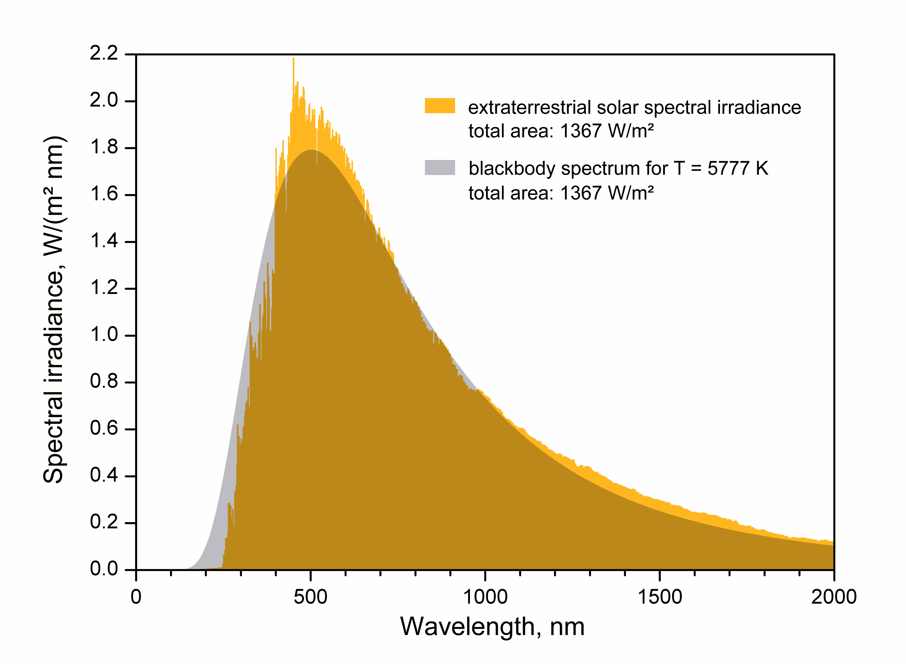
The air mass coefficient defines the direct optical path length through the Earth's atmosphere, expressed as a ratio relative to the path length vertically upwards, i.e. at the zenith. The air mass coefficient can be used to help characterize the solar spectrum after solar radiation has traveled through the atmosphere. The air mass coefficient is commonly used to characterize the performance of solar cells under standardized conditions, and is often referred to using the syntax "AM" followed by a number. "AM1.5" is almost universal when characterizing terrestrial power-generating panels. Description The overall intensity of solar radiation is like that of a black body radiator of the same size at about 5,800 K.or more precisely 5,777 K as reported iNASA Solar System Exploration - Sun: Facts & Figures retrieved 27 April 2011 "Effective Temperature ... 5777 K" As it passes through the atmosphere, sunlight is attenuated by scattering and absorption; the more atmo ... [...More Info...] [...Related Items...] OR: [Wikipedia] [Google] [Baidu] |
Optical Path Length
In optics, optical path length (OPL, denoted ''Λ'' in equations), also known as optical length or optical distance, is the length that light needs to travel through a vacuum to create the same phase difference as it would have when traveling through a given medium. It is calculated by taking the product of the geometric length of the optical path followed by light and the refractive index of the homogeneous medium through which the light ray propagates; for inhomogeneous optical media, the product above is generalized as a path integral as part of the ray tracing procedure. A difference in OPL between two paths is often called the optical path difference (OPD). OPL and OPD are important because they determine the phase of the light and govern interference and diffraction of light as it propagates. In a medium of constant refractive index, ''n'', the OPL for a path of geometrical length ''s'' is just :\mathrm = n s .\, If the refractive index varies along the path, the OPL is ... [...More Info...] [...Related Items...] OR: [Wikipedia] [Google] [Baidu] |
Zenith Angle
The zenith (, ) is the imaginary point on the celestial sphere directly "above" a particular location. "Above" means in the vertical direction ( plumb line) opposite to the gravity direction at that location ( nadir). The zenith is the "highest" point on the celestial sphere. The direction opposite of the zenith is the nadir. Origin The word ''zenith'' derives from an inaccurate reading of the Arabic expression (), meaning "direction of the head" or "path above the head", by Medieval Latin scribes in the Middle Ages (during the 14th century), possibly through Old Spanish. It was reduced to ''samt'' ("direction") and miswritten as ''senit''/''cenit'', the ''m'' being misread as ''ni''. Through the Old French ''cenith'', ''zenith'' first appeared in the 17th century. Relevance and use The term ''zenith'' sometimes means the highest point, way, or level reached by a celestial body">culmination">highest point, way, or level reached by a celestial body on its daily apparent pa ... [...More Info...] [...Related Items...] OR: [Wikipedia] [Google] [Baidu] |
Daylight
Daylight is the combination of all direct and indirect sunlight during the daytime. This includes direct sunlight, diffuse sky radiation, and (often) both of these reflected by Earth and terrestrial objects, like landforms and buildings. Sunlight scattering, scattered or reflected by astronomical objects is generally not considered daylight. Therefore, daylight excludes moonlight, despite it being reflected indirect sunlight. Definition Daylight is present at a particular location, to some degree, whenever the Sun is above the local horizon. This is true for slightly more than 50% of the Earth at any given time, since the Earth's atmosphere refracts some sunlight even when the Sun is below the horizon. Outdoor illuminance varies from 120,000 lux for direct sunlight at noon, which may cause eye pain, to less than 5 lux for thick storm clouds with the Sun at the horizon (even <1 lux for the most extreme case), which may make shadows from distant street lights visible. It may be d ... [...More Info...] [...Related Items...] OR: [Wikipedia] [Google] [Baidu] |
SMARTS (The Simple Model Of The Atmospheric Radiative Transfer Of Sunshine)
The Simple Model of the Atmospheric Radiative Transfer of Sunshine (SMARTS) is a computer program designed to evaluate the surface solar irradiance components in the shortwave spectrum (spectral range 280 to 4000 nm) under cloudless conditions. The program, written in FORTRAN, relies on simplifications of the equation of radiative transfer to allow extremely fast calculations of the surface irradiance. The irradiance components can be incident on a horizontal, a fixed-tilt or a 2-axis tracking surface. SMARTS can be used for example to evaluate the energy production of solar panels under variable atmospheric conditions. Many other applications are possible. History The first versions of SMARTS were developed by Dr. Gueymard while he was at the Florida Solar Energy Center. The model employed a structure similar to the earlier SPCTRAL2 model, still offered bthe National Renewable Energy Laboratory(NREL), but with finer spectral resolution, as well as updated extraterrestrial spe ... [...More Info...] [...Related Items...] OR: [Wikipedia] [Google] [Baidu] |
Solar Zenith Angle
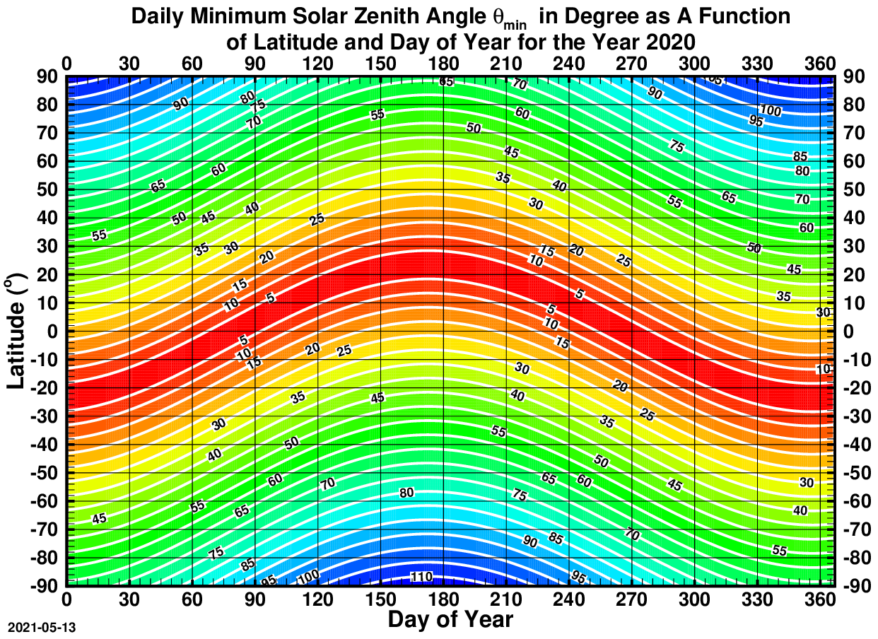
The solar zenith angle is the zenith angle of the sun, i.e., the angle between the sun’s rays and the vertical direction. It is the complement to the solar altitude or solar elevation, which is the altitude angle or elevation angle between the sun’s rays and a horizontal plane. At solar noon, the altitude angle (complement of the solar angle) is at a minimum and is equal to latitude minus solar declination angle. This is the basis by which ancient mariners navigated the oceans. Solar zenith angle is normally used in combination with the solar azimuth angle to determine the position of the Sun as observed from a given location on the surface of the Earth. Formula \cos \theta_s = \sin \alpha_s = \sin \Phi \sin \delta + \cos \Phi \cos \delta \cos h where * \theta_s is the ''solar zenith angle'' * \alpha_s is the ''solar altitude angle'', \alpha_s = 90^\circ - \theta_s * h is the hour angle, in the local solar time. * \delta is the current declination of the Sun * \Phi is the ... [...More Info...] [...Related Items...] OR: [Wikipedia] [Google] [Baidu] |
Temperate
In geography, the temperate climates of Earth occur in the middle latitudes (approximately 23.5° to 66.5° N/S of the Equator), which span between the tropics and the polar regions of Earth. These zones generally have wider temperature ranges throughout the year and more distinct seasonal changes compared to tropical climates, where such variations are often small; they usually differ only in the amount of precipitation. In temperate climates, not only do latitude, latitudinal positions influence temperature changes, but various sea currents, prevailing wind direction, continentality (how large a landmass is) and altitude also shape temperate climates. The Köppen climate classification defines a climate as "temperate" C, when the mean temperature is above but below in the coldest month to account for the persistence of frost. However, some adaptations of Köppen set the minimum at . Continental climate, Continental climates are classified as D and considered to be varie ... [...More Info...] [...Related Items...] OR: [Wikipedia] [Google] [Baidu] |
Tropical
The tropics are the regions of Earth surrounding the equator, where the sun may shine directly overhead. This contrasts with the temperate or polar regions of Earth, where the Sun can never be directly overhead. This is because of Earth's axial tilt; the width of the tropics (in latitude) is twice the tilt. The tropics are also referred to as the tropical zone and the torrid zone (see geographical zone). Due to the overhead sun, the tropics receive the most solar energy over the course of the year, and consequently have the highest temperatures on the planet. Even when not directly overhead, the sun is still close to overhead throughout the year, therefore the tropics also have the lowest seasonal variation on the planet; "winter" and "summer" lose their temperature contrast. Instead, seasons are more commonly divided by precipitation variations than by temperature variations. The tropics maintain wide diversity of local climates, such as rain forests, monsoons, sa ... [...More Info...] [...Related Items...] OR: [Wikipedia] [Google] [Baidu] |
Equatorial Climate
A tropical rainforest climate or equatorial climate is a tropical climate sub-type usually found within 10 to 15 degrees latitude of the equator. There are some other areas at higher latitudes, such as the coast of southeast Florida, United States, and Okinawa, Japan that fall into the tropical rainforest climate category. They experience high mean annual temperatures, small temperature ranges, and rain that falls throughout the year. Regions with this climate are typically designated ''Af'' by the Köppen climate classification. A tropical rainforest climate is typically hot, very humid, and wet with no dry season. Description Tropical rainforests have a type of tropical climate (with an average temperature of at least in their coldest month) in which there is no dry season—all months have an average precipitation value of at least . There are no distinct wet or dry seasons as rainfall is high throughout the months. One day in a tropical rainforest climate can be very similar ... [...More Info...] [...Related Items...] OR: [Wikipedia] [Google] [Baidu] |
Communications Satellite
A communications satellite is an artificial satellite that relays and amplifies radio telecommunication signals via a Transponder (satellite communications), transponder; it creates a communication channel between a source transmitter and a Radio receiver, receiver at different locations on Earth. Communications satellites are used for television, telephone, radio, internet, and military applications. Many communications satellites are in geostationary orbit above the equator, so that the satellite appears stationary at the same point in the sky; therefore the satellite dish antennas of ground stations can be aimed permanently at that spot and do not have to move to track the satellite. Others form satellite constellations in low Earth orbit, where antennas on the ground have to follow the position of the satellites and switch between satellites frequently. The radio waves used for telecommunications links travel by Line-of-sight propagation, line of sight and so are obstructe ... [...More Info...] [...Related Items...] OR: [Wikipedia] [Google] [Baidu] |
Barometric Formula
The barometric formula is a formula used to model how the air pressure (or air density) changes with altitude. Pressure equations There are two equations for computing pressure as a function of height. The first equation is applicable to the atmospheric layers in which the temperature is assumed to vary with altitude at a non null lapse rate of L_b: P = P_ \left 1 - \frac (h - h_)\right The second equation is applicable to the atmospheric layers in which the temperature is assumed not to vary with altitude ( lapse rate is null): P = P_b \exp \left frac\right/math> where: *P_b = reference pressure *T_ = reference temperature ( K) *L_ = temperature lapse rate (K/m) in ISA *h = geopotential height at which pressure is calculated (m) *h_b = geopotential height of reference level ''b'' (meters; e.g., ''hb'' = 11 000 m) *R^* = universal gas constant: 8.3144598 J/(mol·K) *g_0 = gravitational acceleration: 9.80665 m/s2 *M = molar mass of Earth's air: 0.0289644&nb ... [...More Info...] [...Related Items...] OR: [Wikipedia] [Google] [Baidu] |
Levelling
Levelling or leveling (American English; see spelling differences) is a branch of surveying, the object of which is to establish or verify or measure the height of specified points relative to a datum. It is widely used in geodesy and cartography to measure vertical position with respect to a vertical datum, and in construction to measure height differences of construction artifacts. In photolithography, the same term is used in a lithography machine calibration step measuring or calibrating wafer surface height with respect to a reference. Optical levelling Optical levelling, also known as spirit levelling and differential levelling, employs an '' optical level'', which consists of a precision telescope with crosshairs and stadia marks. The cross hairs are used to establish the level point on the target, and the stadia allow range-finding; stadia are usually at ratios of 100:1, in which case one metre between the stadia marks on the '' level staff'' (or ''rod'') represents ... [...More Info...] [...Related Items...] OR: [Wikipedia] [Google] [Baidu] |


