|
2013 New Brunswick Electoral Redistribution
The 2013 New Brunswick electoral redistribution was undertaken through the process set out in the ''Electoral Boundaries and Representation Act'' of New Brunswick, Canada. The legislation establishes a statutory requirement for redistricting, redistribution of electoral district (Canada), electoral districts after every second List of post-confederation New Brunswick general elections, New Brunswick general election. A commission was struck to draw 49 electoral districts, a decrease from 55 districts, which will first be used in the 2014 New Brunswick general election, 2014 provincial election. The 49 boundaries will have to be within the range of 95% to 105% of the 1/49th of the number of registered voters in the province except in "extraordinary circumstances". Under the legislation, the commission will be chaired by one anglophone and one francophone and consist of 3 to 5 other commissioners, all of whom must be New Brunswick residents. Legislative changes The ''Electoral Bo ... [...More Info...] [...Related Items...] OR: [Wikipedia] [Google] [Baidu] |
New Brunswick
New Brunswick is a Provinces and Territories of Canada, province of Canada, bordering Quebec to the north, Nova Scotia to the east, the Gulf of Saint Lawrence to the northeast, the Bay of Fundy to the southeast, and the U.S. state of Maine to the west. It is part of Eastern Canada and is one of the three Maritime Canada, Maritime provinces and one of the four Atlantic Canada, Atlantic provinces. The province is about 83% forested and its northern half is occupied by the Appalachians. The province's climate is continental climate, continental with snowy winters and temperate summers. New Brunswick has a surface area of and 775,610 inhabitants (2021 census). Atypically for Canada, only about half of the population lives in urban areas - predominantly in Moncton, Saint John, New Brunswick, Saint John and Fredericton. In 1969, New Brunswick passed the New Brunswick Official Languages Act (1969), Official Languages Act which began recognizing French as an official language, along ... [...More Info...] [...Related Items...] OR: [Wikipedia] [Google] [Baidu] |
Nigadoo-Chaleur
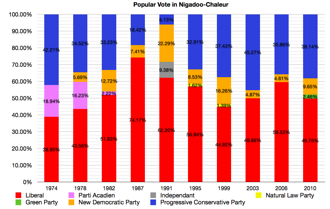
Restigouche-Chaleur was a provincial electoral district for the Legislative Assembly of New Brunswick, Canada. It is a redistribution of the riding of Nigadoo-Chaleur. History and geography Nigadoo-Chaleur was created in the 1973 electoral redistribution as one of the five districts from the previous Gloucester district, defined as the parish of Beresford and the villages in that area of Gloucester County.1974 Report of the Representation and Electoral Boundaries Commission . Retrieved February 21, 2011. It gain ... [...More Info...] [...Related Items...] OR: [Wikipedia] [Google] [Baidu] |
Petitcodiac (electoral District)
Petitcodiac was a provinces and territories of Canada, provincial electoral district (Canada), electoral district for the Legislative Assembly of New Brunswick, Canada. Members of the Legislative Assembly Election results References External links Website of the Legislative Assembly of New Brunswick Former provincial electoral districts of New Brunswick {{NewBrunswick-stub ... [...More Info...] [...Related Items...] OR: [Wikipedia] [Google] [Baidu] |
Gagetown-Petitcodiac
Gagetown-Petitcodiac was a provincial electoral district for the Legislative Assembly of New Brunswick, Canada. It was first contested in the 2014 general election, having been created in the 2013 redistribution of electoral boundaries. The district ran from the boundaries of the town of Oromocto to those of the city of Moncton along New Brunswick Highway 2, and includes only small municipalities and unincorporated communities. It drew significant population the former districts of Petitcodiac, Grand Lake-Gagetown, Oromocto Oromocto is a Canadian town in Sunbury County, New Brunswick. The town is located on the west bank of the Saint John River at the mouth of the Oromocto River, approximately southeast of Fredericton. The town's name is derived from the name o ..., Kings East and Hampton-Kings. Members of the Legislative Assembly Election results References External links Website of the Legislative Assembly of N ... [...More Info...] [...Related Items...] OR: [Wikipedia] [Google] [Baidu] |
York North
York North was a federal riding in Ontario, Canada, that was in the House of Commons of Canada from Confederation in 1867 until 2004. The federal riding was eliminated in 2003 when it was redistributed between two new ridings of Newmarket—Aurora and York—Simcoe. Another small section was incorporated into Oak Ridges—Markham. The riding covered the northern suburbs of the city of Toronto often including such towns as Aurora, Vaughan, Newmarket, Richmond Hill and Markham. The borders changed often, however, most notably in 1996 when the riding was so altered that it contained very little of the same territory as before. Evolution of the riding The British North America Act, 1867 designated the electoral districts to be used in elected the members of the House of Commons. By virtue of the size of its population, the County of York was divided into a number of ridings, instead of being allocated one seat in the House of Commons like many other counties. The initial ... [...More Info...] [...Related Items...] OR: [Wikipedia] [Google] [Baidu] |
Fredericton-York
Fredericton-York is a provinces and territories of Canada, provincial electoral district (Canada), electoral district for the Legislative Assembly of New Brunswick, Legislative Assembly of New Brunswick, Canada. It was first contested in the 2014 New Brunswick general election, 2014 general election, having been created in the New Brunswick electoral redistribution, 2013, 2013 redistribution of electoral boundaries from portions of the former districts of Fredericton-Nashwaaksis and York North (New Brunswick provincial electoral district), York North. The district includes a band of the Fredericton, City of Fredericton along its northern and northwesternmost edges as well as surrounding parts of York County, including Douglas, New Brunswick, Douglas, Nashwaak, New Brunswick, Nashwaak and the Nashwaak River, Nashwaak River Valley. It was initially to be named Fredericton-Stanley but its name was revised to Fredericton-York in the commission's amended final report. Members of t ... [...More Info...] [...Related Items...] OR: [Wikipedia] [Google] [Baidu] |
Fredericton-Lincoln
Fredericton-Lincoln is a provinces and territories of Canada, provincial electoral district (Canada), electoral district for the Legislative Assembly of New Brunswick, Legislative Assembly of New Brunswick, Canada. It was first created in the New Brunswick electoral redistribution, 2006, 2006 redrawing of electoral districts and was first used in the 2006 New Brunswick general election, general election later that year. Its last Member of the Legislative Assembly, MLA was Craig Leonard who served in the Executive Council of New Brunswick, cabinet as Minister of Government Services. History The district was created in the New Brunswick electoral redistribution, 2006, 2006 redistribution primarily from those parts of Fredericton-Fort Nashwaak (1995–2006), Fredericton-Fort Nashwaak south of the Saint John River (Bay of Fundy), Saint John River and the suburban community of Lincoln, New Brunswick, Lincoln from the New Maryland (electoral district), New Maryland district. It al ... [...More Info...] [...Related Items...] OR: [Wikipedia] [Google] [Baidu] |
Fredericton-Silverwood
Fredericton-Silverwood was a provincial electoral district for the Legislative Assembly of New Brunswick, Canada. It was first created using the name Fredericton South in the 1973 redrawing of electoral districts by splitting the two-member district of Fredericton and was first used in the 1974 general election. Its name was changed to Fredericton-Silverwood in the 2006 redrawing of electoral districts. The riding was split in two along Smythe Street in the 2013 redistribution, with half of the riding going to Fredericton South and half to Fredericton West-Hanwell. History It was created in 1973 as Fredericton South and included those portions of the old multi-member district of Fredericton south of the Saint John River. It lost eastern territory in the 1994 electoral redistribution to the new district of Fredericton-Fort Nashwaak and again lost eastern territory in 2006 this time to the new district of Fredericton-Lincoln. Its name was changed in 2006 to Frederi ... [...More Info...] [...Related Items...] OR: [Wikipedia] [Google] [Baidu] |
Fredericton South
Fredericton South () was a provincial electoral district for the Legislative Assembly of New Brunswick, Canada. It was first contested in the 2014 general election, having been created in the 2013 redistribution of electoral boundaries by combining portions of the former districts of Fredericton-Lincoln and Fredericton-Silverwood. The district included the downtown and uptown areas of the southside of the City of Fredericton, including Fredericton City Hall, the Legislative Assembly of New Brunswick, the University of New Brunswick The University of New Brunswick (UNB) is a public university with two primary campuses in Fredericton and Saint John, New Brunswick. It is the oldest English language, English-language university in Canada, and among the oldest public universiti ... and Saint Thomas University. Green Party leader David Coon was elected MLA in 2014 and re-elected in 2018 and 2020. Members of the Legislative Assembly Election results ... [...More Info...] [...Related Items...] OR: [Wikipedia] [Google] [Baidu] |
Fredericton-Nashwaaksis
Fredericton-Nashwaaksis was a provinces and territories of Canada, provincial electoral district (Canada), electoral district for the Legislative Assembly of New Brunswick, Legislative Assembly of New Brunswick, Canada. It was first created in the New Brunswick electoral redistribution, 2006, 2006 redrawing of electoral districts and was first used in the 2006 New Brunswick general election, general election later that year. History It was created in New Brunswick electoral redistribution, 2006, 2006 as a result of rapid population growth in the Fredericton, New Brunswick, City of Fredericton north of the Saint John River (Bay of Fundy), Saint John River. It includes those parts of the old Fredericton North district that were west of the Westmorland Street Bridge as well as some suburban communities previously in the district of Mactaquac (electoral district), Mactaquac. Members of the Legislative Assembly Election results * This was a new di ... [...More Info...] [...Related Items...] OR: [Wikipedia] [Google] [Baidu] |
Fredericton North
Fredericton North () is a provinces and territories of Canada, provincial electoral district (Canada), electoral district for the Legislative Assembly of New Brunswick, Canada from New Brunswick electoral redistribution, 1973, 1973 to New Brunswick electoral redistribution, 2006, 2006, and was contested again in the 2014 New Brunswick general election. It was split between the ridings of Fredericton-Nashwaaksis and Fredericton-Fort Nashwaak from 2006 until 2014. From 1974 to 2003, the riding consisted of the whole of the northside of the city of Fredericton. From 2014, it contained only a subset of that former territory, namely the former towns of Devon, New Brunswick, Devon and Nashwaaksis, New Brunswick, Nashwaaksis (excluding parts north of the Ring Road). Members of the Legislative Assembly Election results 2020–present 1974–2006 Exter ... [...More Info...] [...Related Items...] OR: [Wikipedia] [Google] [Baidu] |


