|
1983 Leeds City Council Election
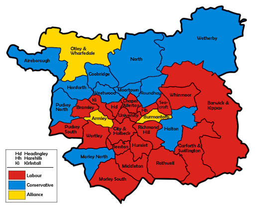
Elections to Leeds City Council were held on Thursday, 5 May 1983, with one third of the council to be elected. The unwinding of much of Alliance's momentum helped Labour defend most of their 1982 losses, with the Conservative and Alliance gains restricted to a seat apiece in Morley North and Burmantofts respectively. The Conservative ousted by the Alliance gain in ultra-marginal Horsforth the year before won his way back onto the council with the only other gain of the night. Election result This result has the following consequences for the total number of seats on the council after the elections: Ward results References {{Leeds Council elections 1983 English ... [...More Info...] [...Related Items...] OR: [Wikipedia] [Google] [Baidu] |
Leeds City Centre
Leeds city centre is the central business district of Leeds, West Yorkshire, England. It is roughly bounded by the Inner Ring Road to the north and the River Aire to the south and can be divided into several quarters. Central districts Arena Quarter The Arena Quarter is a mixed-use area best known for being the home of the First Direct Arena. Its location is directly north of Merrion Street. The Inner Ring Road borders the district on both the east and north boundary, with Woodhouse Lane acting as the district's western boundary. It is mainly made up of high-rise residential properties and developments, including Sky Plaza and Opal 3. Altus House is the tallest building in Yorkshire. Other major institutions are located within the Quarter, including the Yorkshire Bank HQ and also the Merrion Centre. Queen Square is also found here. The Calls The Calls is close to the River Aire. It is directly south of the Retail Quarter and to the west of Crown Point Road. ... [...More Info...] [...Related Items...] OR: [Wikipedia] [Google] [Baidu] |
Otley
Otley is a market town and civil parish at a bridging point on the River Wharfe, in the City of Leeds metropolitan borough in West Yorkshire, England. Historically a part of the West Riding of Yorkshire, the population was 13,668 at the 2011 census. It is in two parts: south of the river is the historic town of Otley and to the north is Newall, which was formerly a separate township. The town is in lower Wharfedale on the A660 road which connects it to Leeds. The town is in the Otley and Yeadon ward of Leeds City Council and the Leeds North West parliamentary constituency. History Toponymy Otley's name is derived from Otto, Otho, Othe, or Otta, a Saxon personal name and ''leah'', a woodland clearing in Old English. It was recorded as ''Ottanlege'' in 972 and ''Otelai'' or ''Othelia'' in the ''Domesday Book'' of 1086. The name Chevin has close parallels to the early Brythonic Welsh term ''Cefn'' meaning ridge and may be a survival of the ancient Cumbric language. Early ... [...More Info...] [...Related Items...] OR: [Wikipedia] [Google] [Baidu] |
Alwoodley (ward)
Alwoodley is an electoral ward of Leeds City Council in the north of Leeds, West Yorkshire, covering the urban suburb areas of Alwoodley, the majority of Moor Allerton (above the Leeds Outer Ring Road) and Slaid Hill. Boundaries The Alwoodley ward includes Slaid Hill and Wigton, the south western and most populous parts of the civil parish of Harewood. Its predecessor, the North ward, also contained the actual village of Harewood and surrounding villages in the parish, including Wike Wike, WIKE, or Wyke may refer to: People ;Surname * Eberechi Wike, a Rivers State High Court judge * Ezenwo Nyesom Wike, Nigerian politician * Tasie Wike, a lawyer Places * Wike, West Yorkshire, a hamlet in Leeds, England * Wyke, Bradford .... They currently sit in the neighbouring Harewood ward. Councillors since 1980 indicates seat up for re-election. indicates seat up for election following resignation or death of sitting councillor. ''*'' indicates incumbent councillo ... [...More Info...] [...Related Items...] OR: [Wikipedia] [Google] [Baidu] |
Moortown (ward)
Moortown is an electoral ward of Leeds City Council in north Leeds, West Yorkshire, covering the suburb of the same name, Meanwood and the southern part of Moor Allerton below the Leeds Outer Ring Road. Councillors since 1973 indicates seat up for re-election. indicates seat up for election following resignation or death of sitting councillor. ''*'' indicates incumbent councillor. Elections since 2010 2022 File:2022 collage V1.png, Clockwise, from top left: Road junction at Yamato-Saidaiji Station several hours after the assassination of Shinzo Abe; Anti-government protest in Sri Lanka in front of the Presidential Secretariat; The global monkeyp ... May 2021 May 2019 May 2018 May 2016 May 2015 May 2014 May 2012 May 2011 May 2010 See also * Listed buildings in Leeds (Moortown Ward) Notes References {{Reflist Places in Leeds Wards of Leeds [...More Info...] [...Related Items...] OR: [Wikipedia] [Google] [Baidu] |
Middleton, Leeds
Middleton is a largely residential suburb of Leeds in West Yorkshire, England and historically a village in the West Riding of Yorkshire. It is situated on a hill south of Leeds city centre and north north-west of London. It sits in the Middleton Park ward of Leeds City Council and Leeds Central parliamentary constituency. The population of Middleton Park ward - which includes Belle Isle - was 26,228 at the 2011 Census. Middleton was occupied before the Norman Conquest and recorded in the ''Domesday Book'' of 1086 as ''Mildetone''. It developed as a manorial estate and its owners began to exploit the coal seams that outcropped within its boundaries. At the start of the Industrial Revolution a wooden wagonway was built to link the coal pits to Leeds. The colliery agent, John Blenkinsop designed an iron railway and its first steam-powered locomotive which was built by Matthew Murray in Holbeck. The coal mines on which the local economy was based lasted until 1968 and the ... [...More Info...] [...Related Items...] OR: [Wikipedia] [Google] [Baidu] |
Kirkstall (ward)
Kirkstall is an electoral ward of Leeds City Council in west Leeds, West Yorkshire, covering Burley, Hawksworth, Kirkstall and the south west corner of West Park. It contains three rail stations: Burley Park, Headingley and Kirkstall Forge. Councillors since 1973 indicates seat up for re-election. ''*'' indicates incumbent councillor. Elections since 2010 May 2022 May 2021 May 2019 May 2018 May 2016 May 2015 May 2014 May 2012 May 2011 May 2010 See also *Listed buildings in Leeds (Kirkstall Ward) Kirkstall is a ward in the metropolitan borough of the City of Leeds, West Yorkshire, England. It contains 48 listed buildings that are recorded in the National Heritage List for England. Of these, one is listed at Grade I, the highest ... Notes References {{notelist Places in Leeds Wards of Leeds ... [...More Info...] [...Related Items...] OR: [Wikipedia] [Google] [Baidu] |
John Battle (politician)
Sir John Dominic Battle, (born 26 April 1951) is a British Labour Party politician, who was the Member of Parliament (MP) for Leeds West from 1987 to 2010. Early life Battle was born in Bradford and educated at St. Paulinus' School, a primary school in Dewsbury; St Michael's College, Underley Hall 1962–1967 (a junior seminary – secondary education – for the training of priests at the Roman Catholic Archdiocese of Liverpool), and at St Joseph's College, Up Holland (1967–1972). Following a year of work, he went to the University of Leeds where he graduated with a bachelor's degree in English in 1976. From 1976 to 1979, he undertook postgraduate research. In 1979, he began to work as a research assistant to Derek Enright, a fellow Catholic and a Member of the European Parliament. Battle gained a seat on the City of Leeds Council in 1980. He chaired the innovative Industry and Employment Committee and later the Housing Committee. He was chosen to contest the Conserva ... [...More Info...] [...Related Items...] OR: [Wikipedia] [Google] [Baidu] |
Hunslet
Hunslet () is an inner-city area in south Leeds, West Yorkshire, England. It is southeast of the city centre and has an industrial past. It is situated in the Hunslet and Riverside ward of Leeds City Council and Leeds Central parliamentary constituency. The population of the previous City and Hunslet council ward at the 2011 census was 33,705. Many engineering companies were based in Hunslet, including John Fowler & Co. manufacturers of traction engines and steam rollers, the Hunslet Engine Company builders of locomotives (including those used during the construction of the Channel Tunnel), Kitson & Co., Manning Wardle and Hudswell Clarke. Many railway locomotives were built in the Jack Lane area of Hunslet. The area has a mixture of modern and 19th century industrial buildings, terraced housing and 20th century housing. It is an area that has grown up significantly around the River Aire in the early years of the 21st century, especially with the construction of modern r ... [...More Info...] [...Related Items...] OR: [Wikipedia] [Google] [Baidu] |
Headingley
Headingley is a suburb of Leeds, West Yorkshire, England, approximately two miles out of the city centre, to the north west along the A660 road. Headingley is the location of the Beckett Park campus of Leeds Beckett University and Headingley Stadium. The vast majority of the area sits in the Headingley and Hyde Park ward of Leeds City Council and Leeds North West parliamentary constituency. History Headingley was mentioned in the ''Domesday Book'' in 1086 as ''Hedingelei'' or ''Hedingeleia'' when it was recorded that Ilbert de Lacy held 7 carucates (about 840 acres) of land. The name is thought to derive from Old English ''Head(d)inga'' 'of the descendants of Head(d)a' + ''lēah'' 'open ground', thus meaning "the clearing of Hedda's people". Headda has sometimes been identified with Saint Hædde. A stone coffin found near Beckett Park in 1995 suggests there may have been an earlier settlement in late Roman or post-Roman times. From Viking times, Headingley was th ... [...More Info...] [...Related Items...] OR: [Wikipedia] [Google] [Baidu] |
Harehills
Harehills is an inner-city area of east Leeds, West Yorkshire, England. It is approximately north east of Leeds city centre. Harehills is situated between the A58 road, A58 (towards Wetherby) and the A64 road, A64 (towards York). It sits in the Gipton and Harehills (ward), Gipton & Harehills ward of Leeds City Council and the Leeds East (UK Parliament constituency), Leeds East House of Commons, parliamentary constituency, between Burmantofts and Gipton, and adjacent to Chapeltown, West Yorkshire, Chapeltown. Its boundaries are defined by the city council as "the boundary of Spencer Place to the West, Harehills Avenue to the North, the boundary of Foundry Place to the East and Compton Road and Stanley Road to the South." As the name suggests, it is a hill area, basically a south-facing slope, with many streets of terraced houses on hills. In the middle is Banstead Park, a grassy slope with trees and play areas, giving a view over the city of Leeds. There are two main shoppi ... [...More Info...] [...Related Items...] OR: [Wikipedia] [Google] [Baidu] |
Temple Newsam (ward)
Temple Newsam is an electoral ward of Leeds City Council in east Leeds, West Yorkshire, covering the outer city suburbs of Colton, Halton, Halton Moor and Whitkirk. Austhorpe is also shared with Cross Gates and Whinmoor ward, whilst the current civil parish boundaries of Austhorpe see its eastern half lie in the western tip of Garforth and Swillington ward. The ward population at the 2011 Census was 21,543 and ward itself is named after the Temple Newsam estate. Boundaries The Temple Newsam ward includes the civil parish of Austhorpe (west half). Councillors since 1973 indicates seat up for re-election. indicates seat up for election following resignation or death of sitting councillor. ''*'' indicates incumbent councillor. Elections since 2010 May 2022 May 2021 May 2019 May 2018 May 2016 May 2015 May 2014 May 2012 May 2011 May 2010 See also *Listed ... [...More Info...] [...Related Items...] OR: [Wikipedia] [Google] [Baidu] |


