|
1956 Chim Earthquake
The 1956 Chim earthquake was a destructive multiple-shock event that occurred on March 16 in Lebanon along a strand of the Dead Sea Transform (DST) fault system. The epicenter was located in the south of Lebanon in the Chouf District. Six thousand homes were destroyed and another 17,000 were damaged. The number of persons killed was 136. Tectonic setting The DST is a long transform fault that runs in a mostly north-south direction from the northern end of the Red Sea along the Jordan Rift Valley to the Taurus Mountains complex in southern Turkey. The left-lateral fault zone marks the boundary of the Arabian Plate and the Sinai-Levantine block and consists of multiple parallel faults. As the fault moves through Lebanon and Syria the fault trace follows a restraining bend and splits into several strands that include the Serghaya, Rachaya, and Roum faults, as well as the prominent Yammouneh fault. Earthquake The Roum fault runs for a length of between the Hula basin the Awali r ... [...More Info...] [...Related Items...] OR: [Wikipedia] [Google] [Baidu] |
Lebanon
Lebanon ( , ar, لُبْنَان, translit=lubnān, ), officially the Republic of Lebanon () or the Lebanese Republic, is a country in Western Asia. It is located between Syria to Lebanon–Syria border, the north and east and Israel to Blue Line (Lebanon), the south, while Cyprus lies to its west across the Mediterranean Sea; its location at the crossroads of the Mediterranean Basin and the Arabs, Arabian hinterland has contributed to History of Lebanon, its rich history and shaped Culture of Lebanon, a cultural identity of demographics of Lebanon#Religious groups, religious diversity. It is part of the Levant region of the Middle East. Lebanon is home to roughly six million people and covers an area of , making it the List of countries and dependencies by area, second smallest country in continental Asia. The official language of the state is Arabic, while French language, French is also formally recognized; the Lebanese Arabic, Lebanese dialect of Arabic is used alongside Mo ... [...More Info...] [...Related Items...] OR: [Wikipedia] [Google] [Baidu] |
Arabian Plate
The Arabian Plate is a minor tectonic plate in the Northern and Eastern Hemispheres. It is one of the three continental plates (along with the African and the Indian Plates) that have been moving northward in geological history and colliding with the Eurasian Plate. That is resulting in a mingling of plate pieces and mountain ranges extending in the west from the Pyrenees, crossing Southern Europe to Iran, forming the Alborz and the Zagros Mountains, to the Himalayas and ranges of Southeast Asia. Lexicology The ''Arabian Plate'' is a designation of the region, and it is also sometimes referred to as the ''Arab Plate''. Borders The Arabian Plate consists mostly of the Arabian Peninsula; it extends westward to the Sinai Peninsula and the Red Sea and northward to the Levant. The plate borders are: *East, with the Indian Plate, at the Owen Fracture Zone *South, with the African Plate to the west and the Somali Plate and the Indian Plate to the east *West, a left lateral ... [...More Info...] [...Related Items...] OR: [Wikipedia] [Google] [Baidu] |
1956 Earthquakes
Events January * January 1 – The Anglo-Egyptian Sudan, Anglo-Egyptian Condominium ends in Sudan. * January 8 – Operation Auca: Five U.S. evangelical Christian Missionary, missionaries, Nate Saint, Roger Youderian, Ed McCully, Jim Elliot and Pete Fleming, are killed for trespassing by the Huaorani people of Ecuador, shortly after making contact with them. * January 16 – Egyptian leader Gamal Abdel Nasser vows to reconquer Palestine (region), Palestine. * January 25–January 26, 26 – Finnish troops reoccupy Porkkala, after Soviet Union, Soviet troops vacate its military base. Civilians can return February 4. * January 26 – The 1956 Winter Olympics open in Cortina d'Ampezzo, Italy. February * February 11 – British Espionage, spies Guy Burgess and Donald Maclean (spy), Donald Maclean resurface in the Soviet Union, after being missing for 5 years. * February 14–February 25, 25 – The 20th Congress of the Communist Party of the Soviet Union is held in Mosc ... [...More Info...] [...Related Items...] OR: [Wikipedia] [Google] [Baidu] |
1956 In Lebanon
Events January * January 1 – The Anglo-Egyptian Condominium ends in Sudan. * January 8 – Operation Auca: Five U.S. evangelical Christian missionaries, Nate Saint, Roger Youderian, Ed McCully, Jim Elliot and Pete Fleming, are killed for trespassing by the Huaorani people of Ecuador, shortly after making contact with them. * January 16 – Egyptian leader Gamal Abdel Nasser vows to reconquer Palestine (region), Palestine. * January 25–January 26, 26 – Finnish troops reoccupy Porkkala, after Soviet Union, Soviet troops vacate its military base. Civilians can return February 4. * January 26 – The 1956 Winter Olympics open in Cortina d'Ampezzo, Italy. February * February 11 – British Espionage, spies Guy Burgess and Donald Maclean (spy), Donald Maclean resurface in the Soviet Union, after being missing for 5 years. * February 14–February 25, 25 – The 20th Congress of the Communist Party of the Soviet Union is held in Moscow. * February 16 – The 1956 ... [...More Info...] [...Related Items...] OR: [Wikipedia] [Google] [Baidu] |
List Of Earthquakes In The Levant
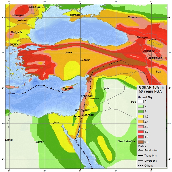
This is a list of earthquakes in the Levant, including earthquakes that either had their epicenter in the Levant or caused significant damage in the region. As it is now, the list is focused on events which affected the territories of modern-day Israel, Jordan, Lebanon, Palestine and Syria and to some degree the adjacent areas of South Anatolia, Cyprus island and the Sinai Peninsula (modern Turkey, Cyprus, Northern Cyprus and Egypt). Seismic hazard The Jordan Rift Valley is the result of tectonic movements within the Dead Sea Transform (DSF) fault system. The DSF forms the transform boundary between the African Plate to the west and the Arabian Plate to the east. The Golan Heights and all of Transjordan are part of the Arabian Plate, while the Galilee, Judean and Samarian highlands (West Bank), Coastal Plain and Negev along with the Sinai Peninsula are on the African Plate. This tectonic disposition leads to a relatively high seismic activity in the region. Earthquakes The regio ... [...More Info...] [...Related Items...] OR: [Wikipedia] [Google] [Baidu] |
List Of Earthquakes In 1956
This is a list of earthquakes in 1956. Only magnitude 6.0 or greater earthquakes appear on the list. Lower magnitude events are included if they have caused death, injury or damage. Events which occurred in remote areas will be excluded from the list as they wouldn't have generated significant media interest. All dates are listed according to UTC time. Again a fairly active year. 11 magnitude 7.0+ earthquakes were recorded with the largest of those striking Greece in the summer. The event in Greece measured 7.7 and was one of the largest ever to affect the country. In all earthquakes in 1956 resulted in 910 fatalities. Iran had the deadliest event of the year with 347 deaths in October. Burma, Lebanon, Afghanistan, Greece and India also suffered from deadly events. Overall By death toll * Note: At least 10 casualties By magnitude * Note: At least 7.0 magnitude Notable events January February March April May June July ... [...More Info...] [...Related Items...] OR: [Wikipedia] [Google] [Baidu] |
Paleoseismic
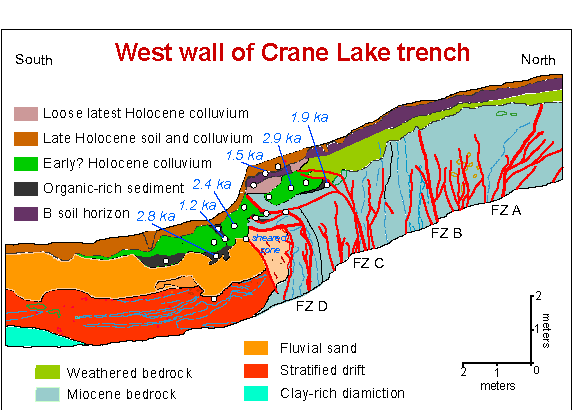
Paleoseismology looks at geologic sediments and rocks, for signs of ancient earthquakes. It is used to supplement seismic monitoring, for the calculation of seismic hazard. Paleoseismology is usually restricted to geologic regimes that have undergone continuous sediment creation for the last few thousand years, such as swamps, lakes, river beds and shorelines. In this typical example, a trench is dug in an active sedimentation regime. Evidence of thrust faulting can be seen in the walls of the trench. It becomes a matter of deducting the relative age of each fault, by cross-cutting patterns. The faults can be dated in absolute terms, if there is dateable carbon, or human artifacts. Many notable discoveries have been made using the techniques of paleoseismology. For example, there is a common misconception that having many smaller earthquakes can somehow 'relieve' a major fault such as the San Andreas Fault, and reduce the chance of a major earthquake. It is now known ( ... [...More Info...] [...Related Items...] OR: [Wikipedia] [Google] [Baidu] |
Awali (river)
The Awali ( ar, نهر الأولي / ALA-LC: ''Nahr al-Awalī'', ancient Bostrenus / Bostrenos) is a perennial river flowing in Southern Lebanon. In ancient times it was known as the River Asclepius. It is long, originating from the Barouk mountain at a height of and the Niha mountain. The Awali is supplemented by two tributaries, the Barouk and Aaray rivers. The Awali is also known as the Bisri river in its upper section; it flows through the western face of Mount Lebanon and into the Mediterranean. The Awali river has a discharge of , it forms a watershed that has an area of about . The river flows into Joun Lake, which is part of the Bisri Dam project to improve the supply of fresh water to the region. A large portion of the Bisri Dam project funding, from the World Bank The World Bank is an international financial institution that provides loans and grants to the governments of low- and middle-income countries for the purpose of pursuing capital projects. The Wor ... [...More Info...] [...Related Items...] OR: [Wikipedia] [Google] [Baidu] |
Taurus Mountains
The Taurus Mountains (Turkish language, Turkish: ''Toros Dağları'' or ''Toroslar'') are a mountain range, mountain complex in southern Turkey, separating the Mediterranean Region, Turkey, Mediterranean coastal region from the central Anatolia#Anatolian plateau, Anatolian Plateau. The system extends along a curve from Lake Eğirdir in the west to the upper reaches of the Euphrates and Tigris rivers in the east. It is a part of the Alpide belt in Eurasia. Etymology The mountain range under the current name was mentioned in The Histories (Polybius), ''The Histories'' by Polybius as Ταῦρος (''Taûros''). Heinrich Kiepert writes in ''Lehrbuch der alten Geographie'' that the name was borrowed into Ancient Greek from the Semitic languages, Semitic (Old Aramaic) root טורא ''ṭūrā'', meaning "mountain". Geography The Taurus mountains are divided into three chains from west to east as follows; * Western Taurus (Batı Toroslar) *Central Taurus (Orta Toroslar) *Southeaster ... [...More Info...] [...Related Items...] OR: [Wikipedia] [Google] [Baidu] |
Dead Sea Transform
The Dead Sea Transform (DST) fault system, also sometimes referred to as the Dead Sea Rift, is a series of faults that run from the Maras Triple Junction (a junction with the East Anatolian Fault in southeastern Turkey) to the northern end of the Red Sea Rift (just offshore of the southern tip of the Sinai Peninsula). The fault system forms the transform boundary between the African Plate to the west and the Arabian Plate to the east. It is a zone of left lateral displacement, signifying the relative motions of the two plates. Both plates are moving in a general north-northeast direction, but the Arabian Plate is moving faster, resulting in the observed left lateral motions along the fault of approximately 107 km at its southern end. A component of extension is also present in the southern part of the transform, which has contributed to a series of depressions, or pull-apart basins, forming the Gulf of Aqaba, Dead Sea, Sea of Galilee, and Hula basins. A component of short ... [...More Info...] [...Related Items...] OR: [Wikipedia] [Google] [Baidu] |
Jordan Rift Valley
The Jordan Rift Valley, also Jordan Valley ''Bīrʿāt haYardēn'', ar, الغور Al-Ghor or Al-Ghawr),, date=November 2022 also called the Syro-African Depression, is an elongated depression located in modern-day Israel, and Jordan. This geographic region includes the entire length of the Jordan River – from its sources, through the Hula Valley, the Korazim block, the Sea of Galilee, the (Lower) Jordan Valley, all the way to the Dead Sea, the lowest land elevation on Earth – and then continues through the Arabah depression, the Gulf of Aqaba whose shorelines it incorporates, until finally reaching the Red Sea proper at the Straits of Tiran. History and physical features The Jordan Rift Valley was formed many millions of years ago in the Miocene epoch (23.8 – 5.3 Myr ago) when the Arabian Plate moved northward and then eastward away from Africa. One million years later, the land between the Mediterranean and the Jordan Rift Valley rose so that the sea wate ... [...More Info...] [...Related Items...] OR: [Wikipedia] [Google] [Baidu] |
Red Sea
The Red Sea ( ar, البحر الأحمر - بحر القلزم, translit=Modern: al-Baḥr al-ʾAḥmar, Medieval: Baḥr al-Qulzum; or ; Coptic: ⲫⲓⲟⲙ ⲛ̀ϩⲁϩ ''Phiom Enhah'' or ⲫⲓⲟⲙ ⲛ̀ϣⲁⲣⲓ ''Phiom ǹšari''; Tigrinya: ቀይሕ ባሕሪ ''Qeyih Bahri''; ) is a seawater inlet of the Indian Ocean, lying between Africa and Asia. Its connection to the ocean is in the south, through the Bab el Mandeb strait and the Gulf of Aden. To its north lie the Sinai Peninsula, the Gulf of Aqaba, and the Gulf of Suez (leading to the Suez Canal). It is underlain by the Red Sea Rift, which is part of the Great Rift Valley. The Red Sea has a surface area of roughly 438,000 km2 (169,100 mi2), is about 2250 km (1398 mi) long, and — at its widest point — 355 km (220.6 mi) wide. It has an average depth of 490 m (1,608 ft), and in the central ''Suakin Trough'' it reaches its maximum depth of . The Red Sea also ha ... [...More Info...] [...Related Items...] OR: [Wikipedia] [Google] [Baidu] |


.jpg)

