|
テ四e-d'Arz
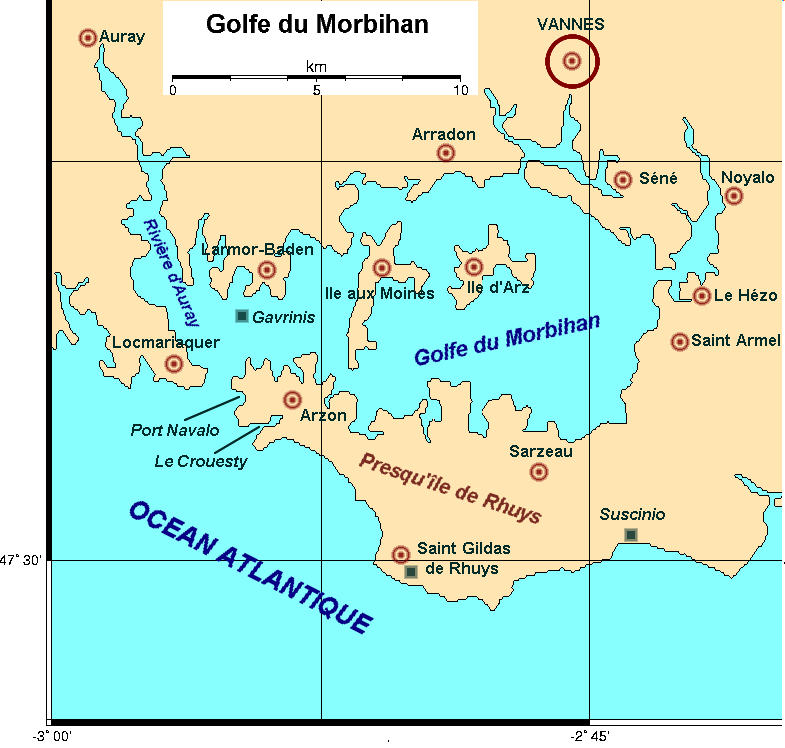
テ四e-d'Arz (; , ) is an archipelago of nine islands and a commune in the Morbihan department, Brittany, northwestern France, only to the southwest of Vannes. It is located in the Gulf of Morbihan. テ四e d'Arz and テ四e-aux-Moines are the only two islands of the gulf that are also communes. Demographics Inhabitants of テ四e-d'Arz are called ''Iledarais''. At the census of 1999, the island had a resident population of 231. On 1 January 2019, the estimate was 221. The population goes as high as 2,500 during summer. The main island contains 550 houses, 30% of which are residential. Economy Lodging There is one hotel open during the summer on the island and one residential hotel open during the whole year. There are two rural gテョtes open the whole year. There is also one campsite which opens during the summer. Artisans There is one mason, one carpenter, one professional painter, and one farmer. Transport There is one bus service between the town and the port, three passenger b ... [...More Info...] [...Related Items...] OR: [Wikipedia] [Google] [Baidu] |
Gulf Of Morbihan
The Gulf of Morbihan (, ; ) is a natural harbour on the coast of the departments of France, department of Morbihan in southern Brittany, France. Its English name is taken from the French language, French version, ''le golfe du Morbihan'', though it would be more precisely called 'the Morbihan' as its Breton language, Breton name 'Ar Mor Bihan' means 'the little sea'. (Compare the Welsh language, Welsh ''y mテエr bychan''), as opposed to the Atlantic Ocean outside, (''Ar Mor Bras''). Legend says that there are as many islands in the Gulf as there are days of the year. In fact the gulf has about 40, depending on the tides. Many islands are private property, except the largest two, テ四e-aux-Moines and テ四e-d'Arz. Geography Tides and currents The gulf is sheltered from the Atlantic Ocean by the peninsula of Rhuys, a small gap between Port-Navalo (in the commune of Arzon) and Kerpenhir (commune of Locmariaquer) lets the water in and out. Because this gap is only approximately wid ... [...More Info...] [...Related Items...] OR: [Wikipedia] [Google] [Baidu] |
テ四e-aux-Moines
テ四e-aux-Moines (; ''Enizenac'h'' in Breton language, Breton; the name means ''island of the monks'') is a Communes of France, commune in the Morbihan Departments of France, department in the region of Brittany (administrative region), Brittany in northwestern France. It is the largest island in the Gulf of Morbihan. It is one of two island communes of the Gulf, the other being テ四e-d'Arz. Geography テ四e-aux-Moines lies in the Gulf of Morbihan. It is by , with an area of 3.1 square kilometres. It is in the shape of a cross and nowhere on the island lies further than 450 metres from the water. Access from the mainland is possible from Larmor-Baden or Port-Blanc. History テ四e-aux-Moines has been inhabited since the Neolithic period, as attested by the dolmens and other relics. In 854, the then king of Brittany, Erispoe, Duke of Brittany, Erispoe, gave a donation to the Abbey of Saint-Conwoテッon in Redon, created by his father Nominoe, Duke of Brittany, Nominoe. This became stor ... [...More Info...] [...Related Items...] OR: [Wikipedia] [Google] [Baidu] |

