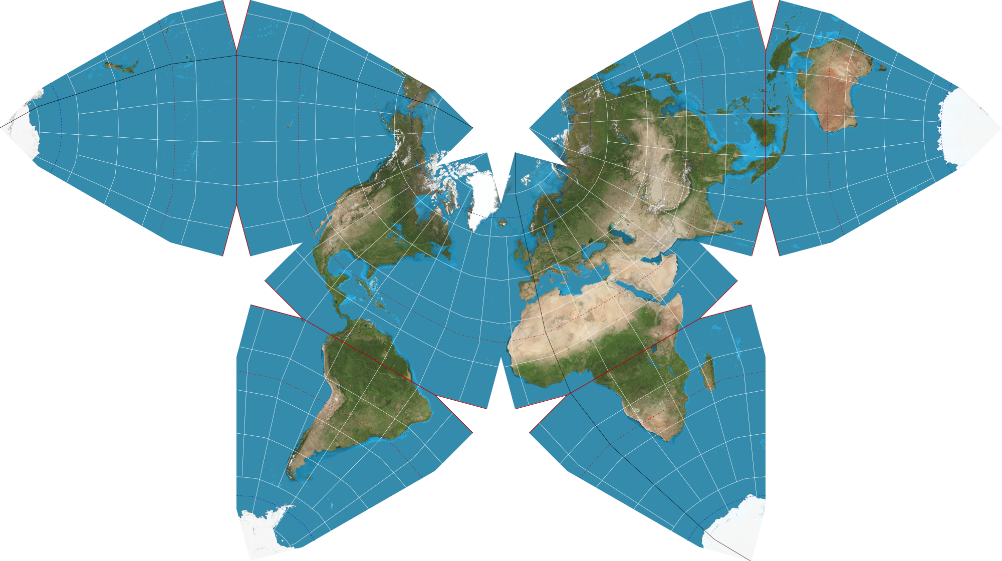
Waterman butterfly projection on:
[Wikipedia]
[Google]
[Amazon]

 The Waterman "Butterfly" World Map is a
"Waterman Projection Method"
''Waterman Project Website'' Waterman chose the W5 Waterman polyhedron and central meridian of 20°W to minimize interrupting major land masses. Popko notes the projection can be gnomonic too. The two methods yield very similar results. Like
Real-time winds and temperature on Waterman projectionInteractive Waterman butterfly mapInteractive Tissot indicatrix of Waterman projection
{{Authority control Map projections

 The Waterman "Butterfly" World Map is a
 map projection
In cartography, map projection is the term used to describe a broad set of transformations employed to represent the two-dimensional curved surface of a globe on a plane. In a map projection, coordinates, often expressed as latitude and longit ...
created by Steve Waterman. Waterman first published a map in this arrangement in 1996. The arrangement is an unfolding of a polyhedral globe with the shape of a truncated octahedron
In geometry, the truncated octahedron is the Archimedean solid that arises from a regular octahedron by removing six pyramids, one at each of the octahedron's vertices. The truncated octahedron has 14 faces (8 regular hexagons and 6 squares), 36 ...
, evoking the ''butterfly map'' principle first developed by Bernard J.S. Cahill (1866–1944) in 1909. Cahill and Waterman map
A map is a symbolic depiction emphasizing relationships between elements of some space, such as objects, regions, or themes.
Many maps are static, fixed to paper or some other durable medium, while others are dynamic or interactive. Although ...
s can be shown in various profiles, typically linked at the north Pacific
The Pacific Ocean is the largest and deepest of Earth's five oceanic divisions. It extends from the Arctic Ocean in the north to the Southern Ocean (or, depending on definition, to Antarctica) in the south, and is bounded by the contine ...
or north Atlantic
The Atlantic Ocean is the second-largest of the world's five oceans, with an area of about . It covers approximately 20% of Earth's surface and about 29% of its water surface area. It is known to separate the " Old World" of Africa, Europe an ...
oceans.
As Cahill was an architect
An architect is a person who plans, designs and oversees the construction of buildings. To practice architecture means to provide services in connection with the design of buildings and the space within the site surrounding the buildings that h ...
, his approach tended toward forms that could be demonstrated physically, such as by his flattenable rubber-ball map. Waterman, on the other hand, derived his design from his work on close-packing of spheres
In geometry, close-packing of equal spheres is a dense arrangement of congruent spheres in an infinite, regular arrangement (or lattice). Carl Friedrich Gauss proved that the highest average density – that is, the greatest fraction of space occu ...
. This involves connecting the sphere centers from cubic closest-packed spheres into a corresponding convex hull, as demonstrated in the accompanying graphics. These illustrate the W5 sphere cluster, W5 convex hull, and two Waterman projections from the W5 convex hull.
To project the sphere to the polyhedron, the Earth
Earth is the third planet from the Sun and the only astronomical object known to harbor life. While large volumes of water can be found throughout the Solar System, only Earth sustains liquid surface water. About 71% of Earth's surfa ...
is divided into eight octants. Each meridian is drawn as three straight-line segments in its respective octant, each segment defined by its endpoints on two of four "Equal Line Delineations" defined by Waterman. These Equal Line Delineations are the North Pole
The North Pole, also known as the Geographic North Pole or Terrestrial North Pole, is the point in the Northern Hemisphere where the Earth's rotation, Earth's axis of rotation meets its surface. It is called the True North Pole to distingu ...
, the northernmost polyhedron edge, the longest line parallel to the equator, and the equator itself. The intersections of all meridians with any one Equal Line Delineation are equally spaced, and the intersections of all parallels with any one meridian are equally spaced.Steve Waterman"Waterman Projection Method"
''Waterman Project Website'' Waterman chose the W5 Waterman polyhedron and central meridian of 20°W to minimize interrupting major land masses. Popko notes the projection can be gnomonic too. The two methods yield very similar results. Like
Buckminster Fuller
Richard Buckminster Fuller (; July 12, 1895 – July 1, 1983) was an American architect, systems theorist, writer, designer, inventor, philosopher, and futurist. He styled his name as R. Buckminster Fuller in his writings, publishing mo ...
's 1943 Dymaxion Projection
The Dymaxion map or Fuller map is a projection of a world map onto the surface of an icosahedron, which can be unfolded and flattened to two dimensions. The flat map is heavily interrupted in order to preserve shapes and sizes.
The projection ...
, an octahedral butterfly map can show all the continents uninterrupted if its octants are divided at a suitable meridian (in this case 20°W) and are joined, for example, at the North Atlantic, as in the 1996 version.
See also
* List of map projections * Waterman polyhedron * Bernard J.S. Cahill *World map
A world map is a map of most or all of the surface of Earth. World maps, because of their scale, must deal with the problem of projection. Maps rendered in two dimensions by necessity distort the display of the three-dimensional surface of th ...
References
External links
Real-time winds and temperature on Waterman projection
{{Authority control Map projections