Stranmillis on:
[Wikipedia]
[Google]
[Amazon]
 Stranmillis () is an area in south
  The Malone and Stranmillis Historic Urban Landscape featured on the 2010 tentative list of sites proposed for addition to the List of World Heritage Sites of the United Kingdom, as an area of architectural interest featuring examples of the Arts and Crafts Movement.

 Several prominent Queen's University buildings are located on Stranmillis Road, including the David Keir Building and the multi-storey Ashby Building, while the University's Physical Education Centre is located close to the river and adjacent to the Botanic Gardens.
Stranmillis Information and Resources
{{Northern Ireland roads Electoral wards of Belfast Streets in Belfast
 Stranmillis () is an area in south
 Belfast
Belfast ( , ; from ga, Béal Feirste , meaning 'mouth of the sand-bank ford') is the capital and largest city of Northern Ireland, standing on the banks of the River Lagan on the east coast. It is the 12th-largest city in the United Kingdom ...
, Northern Ireland
Northern Ireland ( ga, Tuaisceart Éireann ; sco, label= Ulster-Scots, Norlin Airlann) is a part of the United Kingdom, situated in the north-east of the island of Ireland, that is variously described as a country, province or region. Nort ...
. It is also an electoral ward for Belfast City Council
Belfast City Council ( ga, Comhairle Cathrach Bhéal Feirste) is the local authority with responsibility for part of the city of Belfast, the capital and largest city of Northern Ireland. The Council serves an estimated population of (), the ...
, part of the Laganbank district electoral area. As part of the Queen's Quarter, it is the location for prominent attractions such as the Ulster Museum
The Ulster Museum, located in the Botanic Gardens in Belfast, has around 8,000 square metres (90,000 sq. ft.) of public display space, featuring material from the collections of fine art and applied art, archaeology, ethnography, treasure ...
and Botanic Gardens
A botanical garden or botanic gardenThe terms ''botanic'' and ''botanical'' and ''garden'' or ''gardens'' are used more-or-less interchangeably, although the word ''botanic'' is generally reserved for the earlier, more traditional gardens, an ...
. The area is located on Stranmillis Road, with Malone Road
The Malone Road () is a radial road in Belfast, Northern Ireland, leading from the university quarter southwards to the affluent suburbs of Malone and Upper Malone, each a separate electoral ward. The road runs parallel to the Lisburn Road and i ...
to the west and the River Lagan to the east. Its name, meaning "the sweet stream" in Irish, refers to the Lagan, whose waters are still fresh at this point, before becoming brackish as the river flows onward toward its mouth in Belfast Lough
Belfast Lough is a large, intertidal sea inlet on the east coast of Northern Ireland. At its head is the city and port of Belfast, which sits at the mouth of the River Lagan. The lough opens into the North Channel and connects Belfast to ...
.
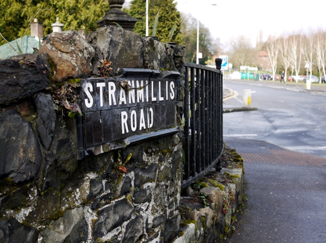
Stranmillis Road begins at the junction of University Road, Malone Road and College Gardens, heading uphill and southwards past Friar's Bush Graveyard and a small shopping district, before descending towards the River Lagan. The route then swings to the west around the outside of Stranmillis College and uphill again, before rejoining the Malone Road. The north end of Stranmillis Road contains many shops and restaurants, while the south end of the road is mainly housing.
 The Malone and Stranmillis Historic Urban Landscape featured on the 2010 tentative list of sites proposed for addition to the List of World Heritage Sites of the United Kingdom, as an area of architectural interest featuring examples of the Arts and Crafts Movement.
History
In the 9th or 10th century A.D. a rath was built on the bank of the Lagan. The site is one of Belfast's best surviving ringforts and now lies in the grounds of Stranmillis College. In 1603 Sir Arthur Chichester was granted expansive lands inUlster
Ulster (; ga, Ulaidh or ''Cúige Uladh'' ; sco, label= Ulster Scots, Ulstèr or ''Ulster'') is one of the four traditional Irish provinces. It is made up of nine counties: six of these constitute Northern Ireland (a part of the United Kin ...
, including all of the land west of the Lagan from Carrickfergus to Dunmurry, and the site of the future City of Belfast. In 1606 he leased his Stranmillis lands for 61 years to Moses Hill, who built a plantation castle. This was described in the Report of the Plantation Commissioner around 1611 as being located at a place called "Stranmellis". The castle guarded a crossing point of the Lagan, close to today's King's Bridge. The site of the castle has been traced to some Victorian farm buildings in the centre of the current estate, and historian George Benn stated during the 19th century that the ruins of the building existed "almost within living memory". Hill also built a second castle at Malone, on the site of what is now Malone House.
Before the lease expired, the Hill family moved out of Stranmillis and the lands reverted to the Chichester family to become the Countess of Donegall's Deer Park. In 1683 Richard Dobbs described it as "a very fine Park, well stored with Venison and in it a Horse Course of Two Miles". A Donegall document defines it as "Stranmellis Park".
Places of interest
Several well-known Belfast landmarks are located in the area, including: *Botanic Gardens
A botanical garden or botanic gardenThe terms ''botanic'' and ''botanical'' and ''garden'' or ''gardens'' are used more-or-less interchangeably, although the word ''botanic'' is generally reserved for the earlier, more traditional gardens, an ...
, a public park opened in 1828, including some rare species in the 19th-century Palm House and Tropical Ravine.
*The Ulster Museum
The Ulster Museum, located in the Botanic Gardens in Belfast, has around 8,000 square metres (90,000 sq. ft.) of public display space, featuring material from the collections of fine art and applied art, archaeology, ethnography, treasure ...
is situated adjacent to the park and has been located in Stranmillis since 1929.
*The Lyric Theatre moved to its current location on the bank of the Lagan in 1968. The theatre was fully redeveloped between 2007 and 2011.
Stranmillis College and Queen's University
Stranmillis University College is located at the midway point of the road. Established as a teaching college in 1922, it is now a constituent college of Queen's University. Several prominent Queen's University buildings are located on Stranmillis Road, including the David Keir Building and the multi-storey Ashby Building, while the University's Physical Education Centre is located close to the river and adjacent to the Botanic Gardens.
Friar's Bush Graveyard
Friar's Bush Graveyard is one of the oldest Christian sites in Belfast, with some graves dating to the early mediaeval period. The site is marked on a map of 1570. In the 18th century when Catholics were forbidden to build a church in Belfast they met at Friar's Bush which was then outside the town boundary, for Holy Communion. Mass ceased in 1769.River Lagan
The Stranmillis Embankment along the Lagan marks the eastern edge of the Stranmillis area. Atowpath
A towpath is a road or trail on the bank of a river, canal, or other inland waterway. The purpose of a towpath is to allow a land vehicle, beasts of burden, or a team of human pullers to tow a boat, often a barge. This mode of transport w ...
runs from here along the river, south to the city of Lisburn and north as far as Jordanstown
Jordanstown ( ga, Baile Mhic Shiúrtáin) is a townland (of 964 acres) and electoral ward in County Antrim, Northern Ireland. It is within the urban area of Newtownabbey and the Antrim and Newtownabbey Borough Council area. It is also situate ...
. On Lockview Road where Stranmillis meets the river, a number of boating organisations including Queen's University Belfast Boat Club
Queen's University Belfast Boat Club (QUBBC) is the boat club of Queen's University Belfast in Belfast, Northern Ireland. It is based on the River Lagan in the Stranmillis area of the city, about 10 minutes' walk from the university.
History
...
have access to the water.
World Heritage Site nomination
In 2010 the Malone and Stranmillis Historic Urban Landscape was added to the tentative list of sites proposed for addition to the List of World Heritage Sites of the United Kingdom as an area of architectural interest featuring examples of the Arts and Crafts Movement. The site was not put forward for the UK shortlist in 2011.See also
* Stranmillis Primary SchoolReferences
External links
Stranmillis Information and Resources
{{Northern Ireland roads Electoral wards of Belfast Streets in Belfast