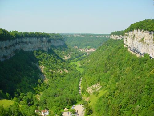
Steephead valley on:
[Wikipedia]
[Google]
[Amazon]
 A steephead valley, steephead or blind valley is a deep, narrow, flat bottomed
 A steephead valley, steephead or blind valley is a deep, narrow, flat bottomed
 valley
A valley is an elongated low area often running between hills or mountains, which will typically contain a river or stream running from one end to the other. Most valleys are formed by erosion of the land surface by rivers or streams ove ...
with an abrupt ending. Such closed valleys may arise in limestone
Limestone ( calcium carbonate ) is a type of carbonate sedimentary rock which is the main source of the material lime. It is composed mostly of the minerals calcite and aragonite, which are different crystal forms of . Limestone forms w ...
or karst
Karst is a topography formed from the dissolution of soluble rocks such as limestone, Dolomite (rock), dolomite, and gypsum. It is characterized by underground drainage systems with sinkholes and caves. It has also been documented for more weathe ...
landscapes, where a layer of permeable rock lies above an impermeable substract such as marl
Marl is an earthy material rich in carbonate minerals, clays, and silt. When hardened into rock, this becomes marlstone. It is formed in marine or freshwater environments, often through the activities of algae.
Marl makes up the lower part ...
. Water flowing through a steephead valley leaves via one or more ponor
A ponor is a natural opening where surface water enters into underground passages; they may be found in karst landscapes where the geology and the geomorphology is typically dominated by porous limestone rock. Ponors can drain stream or lake wate ...
s or sinkhole
A sinkhole is a depression or hole in the ground caused by some form of collapse of the surface layer. The term is sometimes used to refer to doline, enclosed depressions that are locally also known as ''vrtače'' and shakeholes, and to openi ...
s.
Blind valleys are typically dry at their lower ends. If the ponor cannot contain the high runoff during a flood event an intermittent flow may continue through the valley beyond the sink. Such a landform is called a semi-blind or half-blind valley.
Development
They are created by a stream flowing within the permeable rock and eroding it from within, until the rock above collapses opening up a steep narrow valley which is then further eroded by the stream running across the impermeable valley floor. At the head of the valley the stream emerges from the rock as a spring. Notable examples can be found in the Jura region ofFrance
France (), officially the French Republic ( ), is a country primarily located in Western Europe. It also comprises of Overseas France, overseas regions and territories in the Americas and the Atlantic Ocean, Atlantic, Pacific Ocean, Pac ...
, for example the Reculée de Baume at Baume-les-Messieurs
Baume-les-Messieurs () is a commune in the Jura department in the region of Bourgogne-Franche-Comté in eastern France.
The village lies within the most extensive of the steephead valleys of the Jura escarpment, the ''Reculée de Baume''. ...
and the Reculée d'Arbois with its head at Les Planches-près-Arbois
Les Planches-près-Arbois (, literally ''Les Planches near Arbois'') is a commune in the Jura department in Bourgogne-Franche-Comté in eastern France.
Population
Geography
The village is located in the Reculée des Planches, a gorge whi ...
and its exit at Arbois
Arbois () is a commune in the Jura department, in the Bourgogne-Franche-Comté region, eastern France. The river Cuisance passes through the town, which centres on an arcaded central square where one can sample the local wines.
The commune ha ...
.
In North America
North America is a continent in the Northern Hemisphere and almost entirely within the Western Hemisphere. It is bordered to the north by the Arctic Ocean, to the east by the Atlantic Ocean, to the southeast by South America and th ...
, blind valleys (the preferred American term) are found in the Driftless Area
The Driftless Area, a topographical and cultural region in the American Midwest, comprises southwestern Wisconsin, southeastern Minnesota, northeastern Iowa, and the extreme northwestern corner of Illinois.
Never covered by ice during the las ...
and other karst regions.
Examples
*Tasghîmût
''Tasghîmût'' (also Tashgimut, Tashgimout) is a medieval fortress near Marrakesh, Morocco, built on a rocky plateau (an " erosion cirque") and fortified by the Almoravids under Ali ibn Yusuf in the 12th century to protect the nearby capital of A ...
*Gara Medouar
Gara Medouar, also known as Jebel Mudawwar ("round mountain"), Gara Mdouar or Mdoura, is a horseshoe-shaped geological formation (" erosion cirque") near Sijilmasa, Morocco. In the 11th century it was developed into a fortress with a military gar ...
See also
*Box canyon
A canyon (from ; archaic British English spelling: ''cañon''), or gorge, is a deep cleft between escarpments or cliffs resulting from weathering and the erosive activity of a river over geologic time scales. Rivers have a natural tendency to cu ...
References
Canyons and gorges Geomorphology Valleys {{topography-stub