Peruvannamuzhi on:
[Wikipedia]
[Google]
[Amazon]
Peruvannamuzhi or Peruvannamoozhy is a village in Chakkittapara Panchayath


Peruvannamuzhi
Peruvannamuzhi
{{Kozhikode district Kuttiady area
Kozhikode district
Kozhikode (), or Calicut district, is one of the 14 districts in the Indian state of Kerala, along its Southwestern Malabar Coast. The city of Kozhikode, also known as Calicut, is the district headquarters. The district is 67.15% urbanised. ...
, Kerala
Kerala ( ; ) is a state on the Malabar Coast of India. It was formed on 1 November 1956, following the passage of the States Reorganisation Act, by combining Malayalam-speaking regions of the erstwhile regions of Cochin, Malabar, South Ca ...
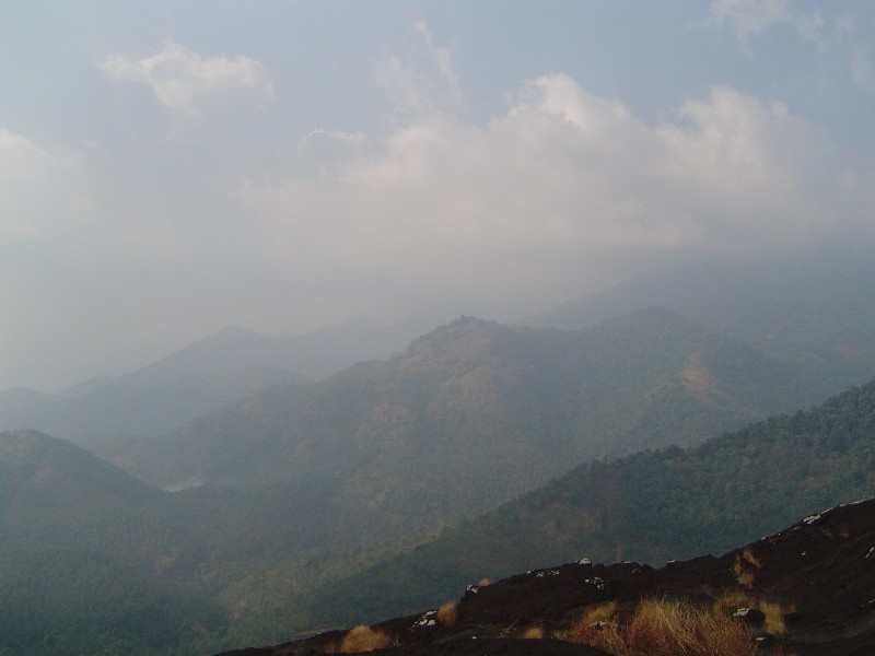
, India. Peruvannamuzhi forms part of the newly inaugurated Malabar Wildlife Sanctuary and is rich in flora and fauna.
Tourism
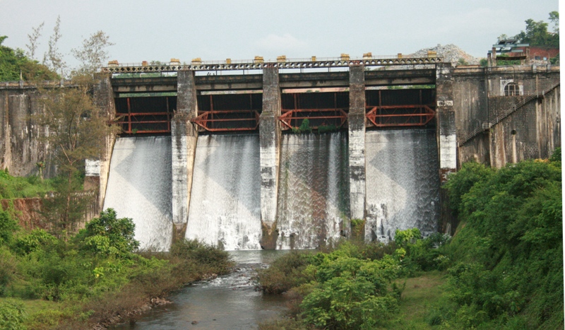
The main attraction of Peruvannamuzhi is its natural splendor, a calm and quiet land nestled in the Western Ghats. Kuttiyadi Irrigation Project Dam is situated in Peruvannamuzhi. Peruvannamuzhi is known for tourism, wildlife and research on spice crops. There is a reservoir with facilities for boating, and nature reserves. The reservoir supplies irrigation water toKozhikode
Kozhikode (), also known in English as Calicut, is a city along the Malabar Coast in the state of Kerala in India. It has a corporation limit population of 609,224 and a metropolitan population of more than 2 million, making it the second ...
, Malapuram and Kannur
Kannur (), formerly known in English as Cannanore, is a city and a municipal corporation in the state of Kerala, India. It is the administrative headquarters of the Kannur district and situated north of the major port city and commercial hu ...
. Other attractions include a crocodile farm and gardens. Peruvannamuzhi is rich in bird life and over 90 species of birds have been recorded at the Experimental Farm of Indian Institute of Spices Research.


Peruvannamuzhi Dam
(within 5 km from Chempanoda) Peruvannamoozhy, a scenic village located 60 km Kozhikode city, Kerala has been included in the list of eco-tourism destinations in Kerala with the Tourism Minister inaugurating the eco-tourism project here on 10 August 2008. An ecological hotspot in the Western Ghats, the eco tourism destination of Peruvannamoozhy is home to over 680 species of rare plants. The facilities available here include wild animal rehabilitation centre, bird sanctuary, crocodile farm, snake park, spice garden, trekking and boating. The reservoir here provides facilities for speedboat and rowboat cruises. There is a garden called Smaraka Thottam, which is built in the memory of the freedom fighters of the region. Uninhabited islands add to the charm of the place.Activities
The area is an ideal location for nature enthusiasts. The irrigation dam and the garden nearby are added attractions. As part of ecotourism initiatives, the following facilities have been created: What to do/Visit in Peruvannamoozhy * Animal rehabilitation centre * Bathing facility in river * Bird sanctuary * Snake park * Trekking programmes * Bamboo rafting * speedboat and rowboat cruisesAccess
How to reach Peruvannamuzhi Dam 1) By road: the Peruvannamuzhi Dam can be reached by road within two hours from Kozhikode city 2) By rail: the nearby railway station is Vatakara Railway Station 3) By air: the nearby airport is Karipur International AirportMinor attractions
* Crocodile farm (within 5 km from Chempanoda) * Janakikadu (within 5 km from Chempanoda) Janakikadu is a thick forest which attracts thousands of tourists every year. There is a wide variety of birds in this forest. An ecological hot spot in the Western Ghats, the ecotourism destination of Janakikadu is home to over 680 species of rare plants. * Pottiyapara (within 5 km from Chempanoda) This region offers immense scope for picnicking and Trekking programmes. The area is an ideal location for nature enthusiasts. The 360° scenic view of the valley from the top of Pottiyapara is breathtaking.History
The history of Peruvannamuzhi closely related to the history ofPerambra
Perambra is a major town in Koyilandy taluk of Kozhikode district in North Malabar region of Kerala state, India. It is one of the 140 assembly constituencies in Kerala, and one of the 12 block Panchayats in Kozhikode district. Perambra lies ...
, a town in Koyilandy
A Survey of Kerala History, A. Shreedhara Menon ar, Fundriya pt, Pandarani
, settlement_type = MunicipalityTaluk
, image_skyline = KadaloorPointLight 01.jpg
, image_alt =
, image_caption ...
taluk of Kozhikode district
Kozhikode (), or Calicut district, is one of the 14 districts in the Indian state of Kerala, along its Southwestern Malabar Coast. The city of Kozhikode, also known as Calicut, is the district headquarters. The district is 67.15% urbanised. ...
in North Malabar region of Kerala
Kerala ( ; ) is a state on the Malabar Coast of India. It was formed on 1 November 1956, following the passage of the States Reorganisation Act, by combining Malayalam-speaking regions of the erstwhile regions of Cochin, Malabar, South Ca ...
state, India. Perambra Village was part of 'Payyormala Nadu' in the past. Payyormala was subject to the Paleri, Avinhatt and Koothali Nayars of Payyörmala. They were independent chieftains, with some theoretical dependence on the Kurumbrunad family and also on the Zamorin.
In 1941, O.C Jose from Ullattikulam, Chalakudi
Chalakudy is a municipal town situated on the banks of Chalakudy River in Thrissur district of the Kerala state in India. It is the headquarters of Chalakudy taluk. It is the base camp for travellers to Athirappilly Falls and Vazhachal Fal ...
bought the Peruvannamuzhi area from Avinhatt Thambai's sister Parukutti Amma.
In 1941, five people from Travancore, Paikayil Thomman from Paika (Pala Pala may refer to:
Places
Chad
*Pala, Chad, the capital of the region of Mayo-Kebbi Ouest
Estonia
*Pala, Kose Parish, village in Kose Parish, Harju County
*Pala, Kuusalu Parish, village in Kuusalu Parish, Harju County
* Pala, Järva County, vil ...
) Kottayam
Kottayam () is a municipal town in the Indian state of Kerala. Flanked by the Western Ghats on the east and the Vembanad Lake and paddy fields of Kuttanad on the west. It is the district headquarters of Kottayam district, located in south ...
, Kallur Joseph from Erumeli
Erumely, also spelt "Erumeli" is a panchayat in the southeast part of Kottayam district in Kerala state, India. Erumely is situated 49 km east of Kottayam town and 133 km North of capital city Trivandrum. It is situated on the way to Sa ...
, Madathinakathu Chacko, Vattothu Kutty, Kulathinkal Varkey bought the Peruvannamuzhi area from O.C Jose for 10 (ten) rupees per acre. The history of Peruvannamuzhi and nearby villages started here.
Peruvanamuzhi Fathima Matha Catholic church is established in 1953 under the guidance of Fr. C J Varkey. This was followed by the construction of Fathima Matha Primary School, the first school in the area.

Major organizations
Indian Institute of Spices Research
The Indian Institute of Spices Research (IISR) is an autonomous organization engaged in agricultural research related to spices in India. The institute has its headquarters in Moozhikkal, Silver Hills, Kozhikode, Kerala and is a subsidiary of In ...
has a farm here. There is a Farm Science Center of the provincial government. Central Reserve Police Force maintains a battalion here. There is a district agricultural farm at Koovapoyil. There are many forest and irrigation offices in Peruvannamuzhi. The government also maintains a tourist bungalow here which is cheaper than private hotels.
There is a government drinking water project called JBIC. Kuttiady Irrigation project runs the dam administration.
There is one St. Fathima matha Church and a Shrine of Our Lady of Health here. The biggest Hindu temple is called Omcareswaram Kshethram which is located at Pillaperuvanna.
Transportation
Peruvannamuzhi village connects to other parts of India throughVatakara
Vatakara, also spelled Vadakara (formerly Badagara), , french: Bargaret, is a Municipality in the state of Kerala, India. Vatakara is located between Kannur and Kozhikode. The municipality of Vatakara covers an area of and is bordered by ...
town on the west and Kuttiady
Kuttiady is one of the Major towns situated in the north-eastern part of Kozhikode district of Kerala, India. It is located from Vadakara and from Kozhikode. Kuttiady is situated in the slopes of the Western Ghats.
The four-sided junction ...
town on the east. National highway No.66 passes through Vatakara
Vatakara, also spelled Vadakara (formerly Badagara), , french: Bargaret, is a Municipality in the state of Kerala, India. Vatakara is located between Kannur and Kozhikode. The municipality of Vatakara covers an area of and is bordered by ...
and the northern stretch connects to Mangalore
Mangalore (), officially known as Mangaluru, is a major port city of the Indian state of Karnataka. It is located between the Arabian Sea and the Western Ghats about west of Bangalore, the state capital, 20 km north of Karnataka– ...
, Goa and Mumbai
Mumbai (, ; also known as Bombay — the official name until 1995) is the capital city of the Indian state of Maharashtra and the ''de facto'' financial centre of India. According to the United Nations, as of 2018, Mumbai is the secon ...
. The southern stretch connects to Cochin
Kochi (), also known as Cochin ( ) ( the official name until 1996) is a major port city on the Malabar Coast of India bordering the Laccadive Sea, which is a part of the Arabian Sea. It is part of the district of Ernakulam in the state of ...
and Trivandrum
Thiruvananthapuram (; ), also known by its List of renamed Indian cities and states, former name Trivandrum (), is the Capital city, capital of the Indian state of Kerala. It is the most populous city in Kerala with a population of 957,730 as ...
. The eastern National Highway No.54 going through Kuttiady
Kuttiady is one of the Major towns situated in the north-eastern part of Kozhikode district of Kerala, India. It is located from Vadakara and from Kozhikode. Kuttiady is situated in the slopes of the Western Ghats.
The four-sided junction ...
connects to Mananthavady
Mananthavady is a municipality and '' taluk'' in the Wayanad district of Kerala, India.
Etymology
The popular view on the etymology is that the word is derived from "Maane Eytha Vady" (English: "The place where an arrow was shot at the deer") ...
, Mysore
Mysore (), officially Mysuru (), is a city in the southern part of the state of Karnataka, India. Mysore city is geographically located between 12° 18′ 26″ north latitude and 76° 38′ 59″ east longitude. It is located at an altitude o ...
and Bangalore
Bangalore (), officially Bengaluru (), is the capital and largest city of the Indian state of Karnataka. It has a population of more than and a metropolitan population of around , making it the third most populous city and fifth most ...
. The nearest airports are at Kannur
Kannur (), formerly known in English as Cannanore, is a city and a municipal corporation in the state of Kerala, India. It is the administrative headquarters of the Kannur district and situated north of the major port city and commercial hu ...
and Kozhikode
Kozhikode (), also known in English as Calicut, is a city along the Malabar Coast in the state of Kerala in India. It has a corporation limit population of 609,224 and a metropolitan population of more than 2 million, making it the second ...
. The nearest railway station is at Vatakara
Vatakara, also spelled Vadakara (formerly Badagara), , french: Bargaret, is a Municipality in the state of Kerala, India. Vatakara is located between Kannur and Kozhikode. The municipality of Vatakara covers an area of and is bordered by ...
.
External links
Peruvannamuzhi
Peruvannamuzhi
{{Kozhikode district Kuttiady area