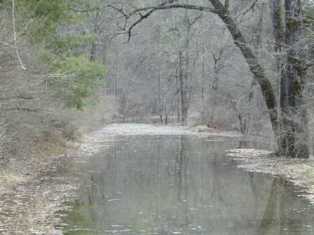
Ompompanoosuc River on:
[Wikipedia]
[Google]
[Amazon]
 The Ompompanoosuc River is a
U.S. Army Corps of Engineers, New England District (last accessed December 31, 2017). The structure is a 170-foot-high earthen dam, creating a seasonal lake in the winter. The West Branch Ompompanoosuc River flows generally southeastwardly through the towns of Vershire and Strafford to Thetford, where it joins the main stem of the river.
 The Ompompanoosuc River is a
 river
A river is a natural flowing watercourse, usually freshwater, flowing towards an ocean, sea, lake or another river. In some cases, a river flows into the ground and becomes dry at the end of its course without reaching another body of w ...
, about 25 mi (40 km) long, in eastern Vermont
Vermont () is a state in the northeast New England region of the United States. Vermont is bordered by the states of Massachusetts to the south, New Hampshire to the east, and New York to the west, and the Canadian province of Quebec to ...
in the United States
The United States of America (U.S.A. or USA), commonly known as the United States (U.S. or US) or America, is a country primarily located in North America. It consists of 50 states, a federal district, five major unincorporated territori ...
. It is a tributary
A tributary, or affluent, is a stream or river that flows into a larger stream or main stem (or parent) river or a lake. A tributary does not flow directly into a sea or ocean. Tributaries and the main stem river drain the surrounding drai ...
of the Connecticut River, which flows to Long Island Sound. According to the Geographic Names Information System
The Geographic Names Information System (GNIS) is a database of name and locative information about more than two million physical and cultural features throughout the United States and its territories, Antarctica, and the associated states of ...
, the river has also been known by the names "Om-pom-pa-noos-uc" and "Pompanoosuc."
The Ompompanoosuc River rises in eastern Orange County in the town of Vershire, and flows generally southwardly through the towns of West Fairlee and Thetford
Thetford is a market town and civil parish in the Breckland District of Norfolk, England. It is on the A11 road between Norwich and London, just east of Thetford Forest. The civil parish, covering an area of , in 2015 had a population of 24, ...
into northeastern Windsor County, where it joins the Connecticut River in the village of Pompanoosuc which is located in the town of Norwich
Norwich () is a cathedral city and district of Norfolk, England, of which it is the county town. Norwich is by the River Wensum, about north-east of London, north of Ipswich and east of Peterborough. As the seat of the See of Norwich, with ...
. DeLorme (1996). ''Vermont Atlas & Gazetteer''. Yarmouth, Maine: DeLorme.
In Thetford, the river is dam
A dam is a barrier that stops or restricts the flow of surface water or underground streams. Reservoirs created by dams not only suppress floods but also provide water for activities such as irrigation, human consumption, industrial use ...
med by the Union Village Dam, which was built from 1946 to 1950 as part of a U.S. Army Corps of Engineers
, colors =
, anniversaries = 16 June (Organization Day)
, battles =
, battles_label = Wars
, website =
, commander1 = ...
project for flood control
Flood control methods are used to reduce or prevent the detrimental effects of flood waters."Flood Control", MSN Encarta, 2008 (see below: Further reading). Flood relief methods are used to reduce the effects of flood waters or high water level ...
.Union Village Dam Flood Risk Management ProjectU.S. Army Corps of Engineers, New England District (last accessed December 31, 2017). The structure is a 170-foot-high earthen dam, creating a seasonal lake in the winter. The West Branch Ompompanoosuc River flows generally southeastwardly through the towns of Vershire and Strafford to Thetford, where it joins the main stem of the river.
See also
* List of Vermont riversReferences