Olkhon Island on:
[Wikipedia]
[Google]
[Amazon]
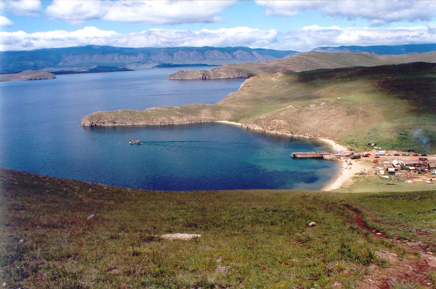
Olkhon ( rus, Ольхо́н, also transliterated as Olchon; bua, Ойхон, ''Oikhon'') is the third-largest lake island in the world. It is by far the largest island in

/ref> There are several settlements and five villages on the island: Yalga, Malomorets, Khuzhir, Kharantsy, and Ulan-Khushin. The village of Khuzhir is the administrative capital of Olkhon, designated as such in April 1987 when the Soviet government issued a comprehensive decree protecting Lake Baikal. Khuzhir is home to about 1,200 residents and boasts a museum of local nature and history.
 The indigenous Buryats, adherents of

 The National History Museum of Revyakin N. M in Khuzhir contains collections of historical items linked to the life and culture of the people of Olkhon from Neolithic times to the present day. Here, visitors can see various items such as stone arrowheads, badges of Mongolian soldiers, and materials used in
  Peschanaya Village is an abandoned settlement famous for its picturesque
 One of the most important ecological problems of Olkhon Island is the disposal of
Photogallery of Olkhon island
Eduard Y. Osipov ., Oleg M. Khlystov. Glaciers and meltwater flux to Lake Baikal during the Last Glacial Maximum // Palaeogeography, Palaeoclimatology, Palaeoecology 294 (2010) 4–15.
{{Authority control Landforms of Irkutsk Oblast Islands of Lake Baikal Dunes of Russia
Lake Baikal
Lake Baikal (, russian: Oзеро Байкал, Ozero Baykal ); mn, Байгал нуур, Baigal nuur) is a rift lake in Russia. It is situated in southern Siberia, between the federal subjects of Irkutsk Oblast to the northwest and the ...
in eastern Siberia
Siberia ( ; rus, Сибирь, r=Sibir', p=sʲɪˈbʲirʲ, a=Ru-Сибирь.ogg) is an extensive geographical region, constituting all of North Asia, from the Ural Mountains in the west to the Pacific Ocean in the east. It has been a part ...
, with an area of . Structurally, it constitutes the southwestern margin of the Academician Ridge
Academician Ridge is an underwater, structural high separating two of Lake Baikal's three basins, the Central and North basins. Situated in the central part of the Baikal Rift, it serves as an "accommodation zone", transferring "motion between faul ...
. The island measures in length and in width.
There are two versions regarding the origin of the name of the island and both are derived from the language of the Buryats
The Buryats ( bua, Буряад, Buryaad; mn, Буриад, Buriad) are a Mongolic ethnic group native to southeastern Siberia who speak the Buryat language. They are one of the two largest indigenous groups in Siberia, the other being the ...
, the indigenous people of Olkhon. The first is that the island's name comes from the word ''oyhon'' – “woody”, and the second is that it comes from ''olhan'' – “dry”. It is still debated which of the two is the actual origin of the name Olkhon as both words describe the island perfectly. Much of the island is still covered by forests and the amount of precipitation is extremely low – about per year.
Geography
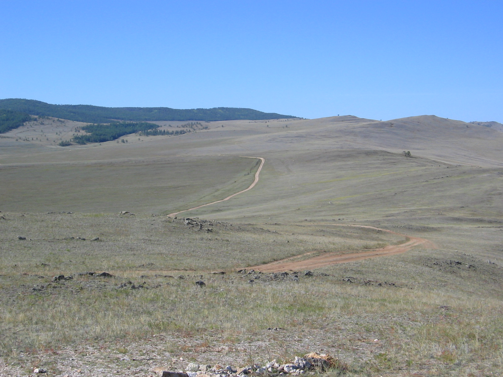
Olkhon has a dramatic combination ofterrain
Terrain or relief (also topographical relief) involves the vertical and horizontal dimensions of land surface. The term bathymetry is used to describe underwater relief, while hypsometry studies terrain relative to sea level. The Latin word ...
and is rich in archaeological landmarks. Steep mountains line its eastern shore, and at above sea level, Mount Zhima is the highest point on the island, peaking at above the water level of Lake Baikal. The island is large enough to have its own lakes, and features a combination of taiga
Taiga (; rus, тайга́, p=tɐjˈɡa; relates to Mongolic and Turkic languages), generally referred to in North America as a boreal forest or snow forest, is a biome characterized by coniferous forests consisting mostly of pines, sp ...
, steppe
In physical geography, a steppe () is an ecoregion characterized by grassland plains without trees apart from those near rivers and lakes.
Steppe biomes may include:
* the montane grasslands and shrublands biome
* the temperate gras ...
and even a small desert
A desert is a barren area of landscape where little precipitation occurs and, consequently, living conditions are hostile for plant and animal life. The lack of vegetation exposes the unprotected surface of the ground to denudation. About on ...
. A deep strait separates the island from the land.
The island's appearance is a result of millions of years of tectonic
Tectonics (; ) are the processes that control the structure and properties of the Earth's crust and its evolution through time. These include the processes of mountain building, the growth and behavior of the strong, old cores of continents ...
movement resulting in the hollowing of the channel between the land (Maloe More
Maloe More (russian: Малое Море; in English literally ''the Small Sea'') is a strait in Lake Baikal, Russia. It separates the largest island of the lake, Olkhon Island, from the western shore of Baikal. The length of the strait is about ...
Sound and Olkhon Gate
Olkhon ( rus, Ольхо́н, also transliterated as Olchon; bua, Ойхон, ''Oikhon'') is the third-largest lake island in the world. It is by far the largest island in Lake Baikal in eastern Siberia, with an area of . Structurally, it const ...
Strait) and the block of stone forming the island. The steep slopes of the mountains show the vertical heave of the earth.

Population
The population of the island is less than 1,744 and consists mostly ofBuryats
The Buryats ( bua, Буряад, Buryaad; mn, Буриад, Buriad) are a Mongolic ethnic group native to southeastern Siberia who speak the Buryat language. They are one of the two largest indigenous groups in Siberia, the other being the ...
, the island's aboriginal people.Greenpeace Russia/ref>
 There are several settlements and five villages on the island: Yalga, Malomorets, Khuzhir, Kharantsy, and Ulan-Khushin. The village of Khuzhir is the administrative capital of Olkhon, designated as such in April 1987 when the Soviet government issued a comprehensive decree protecting Lake Baikal. Khuzhir is home to about 1,200 residents and boasts a museum of local nature and history.
Economy
Most residents are fishermen, farmers, or cattle-ranchers. Due to an increasing number of tourists from all over the world, many residents work in this sector as well, and tourism has become an important part of the economy in Olkhon.Culture
 The indigenous Buryats, adherents of
 shamanism
Shamanism is a religious practice that involves a practitioner (shaman) interacting with what they believe to be a spirit world through altered states of consciousness, such as trance. The goal of this is usually to direct spirits or spiri ...
, believe the island to be a spiritual place; one of the groups of deities revered in Buryati yellow shamanism
Yellow shamanism is the term used to designate a particular version of shamanism practiced in Mongolia and Siberia which incorporates rituals and traditions from Buddhism. "Yellow" indicates Buddhism in Mongolia, since most Buddhists there belong ...
is called the ''oikony noyod'', the "thirteen lords of Olkhon".
On the western coast, close to Khuzhir, is Baikal's most famous landmark, the Shamanka, or Shaman's Rock. Natives believe that Burkhan, a modern religious cult figure of the Altai peoples, lives in the cave in this rock. Olkhon is considered a centre of Kurumchinskay culture of the 6th–10th centuries.
The museum at Olkhon, named after Revyakin, has exhibits on the nature and ethnography of the island, including pipe-smoking
Pipe smoking is the practice of tasting (or, less commonly, inhaling) the smoke produced by burning a substance, most commonly tobacco, in a pipe. It is the oldest traditional form of smoking.
Regular pipe smoking has been cited to carry serious ...
and a samovar
A samovar (russian: самовар, , literally "self-brewer") is a metal container traditionally used to heat and boil water. Although originating in Russia, the samovar is well known outside of Russia and has spread through Russian culture t ...
collection.
History
The island has a long history of human habitation. The original indigenous were theBuryats
The Buryats ( bua, Буряад, Buryaad; mn, Буриад, Buriad) are a Mongolic ethnic group native to southeastern Siberia who speak the Buryat language. They are one of the two largest indigenous groups in Siberia, the other being the ...
and the Yakuts
The Yakuts, or the Sakha ( sah, саха, ; , ), are a Turkic ethnic group who mainly live in the Republic of Sakha in the Russian Federation, with some extending to the Amur, Magadan, Sakhalin regions, and the Taymyr and Evenk Districts ...
.
Russian explorers first visited during the 17th century.
Places of interest
Khuzhir is the main village on Olkhon Island and contains , shops andhomestay
Homestay (also home stay and home-stay) is a form of hospitality and lodging whereby visitors share a residence with a local of the area (host) to which they are traveling. The length of stay can vary from one night to over a year and can be p ...
s.

 The National History Museum of Revyakin N. M in Khuzhir contains collections of historical items linked to the life and culture of the people of Olkhon from Neolithic times to the present day. Here, visitors can see various items such as stone arrowheads, badges of Mongolian soldiers, and materials used in
 cremation
Cremation is a method of Disposal of human corpses, final disposition of a Cadaver, dead body through Combustion, burning.
Cremation may serve as a funeral or post-funeral rite and as an alternative to burial. In some countries, including India ...
rituals, and can learn about life on this island of political exiles in the Soviet era, as well as the unique flora and fauna that can only be found on Olkhon Island.
The Revyakin Museum was originally named after a famous geologist, paleontologist, geographer and writer of science fiction, Obruchev. However, it was later named after its founder, and a teacher of geography, N. M. Revyakin.
sand dune
A dune is a landform composed of wind- or water-driven sand. It typically takes the form of a mound, ridge, or hill. An area with dunes is called a dune system or a dune complex. A large dune complex is called a dune field, while broad, f ...
s and the unique appearance of the trees found here – stilted trees with their roots exposed above the sand. The constant winds that blow from the sea towards land move the sand away from the shore and form high sand hills, which are called "moving sands", as these sand dunes constantly change location depending on the direction of the wind. This strong wind has also resulted in the exposure of roots of trees near the shore, giving the trees the appearance of a standing person, thus earning them the name "walking trees".
Furthermore, there used to be a gulag
The Gulag, an acronym for , , "chief administration of the camps". The original name given to the system of camps controlled by the State Political Directorate, GPU was the Main Administration of Corrective Labor Camps (, )., name=, group= ...
fish factory here where prisoners worked during Soviet times. However, after Stalin's death, these prisoners were released, and the factory has been abandoned since the 1950s.
Three Brothers Rock, or Sagaan-Khushun Cape, is one of Baikal's natural monuments and another popular tourist sightseeing spot. It is easily recognised as three big rocks standing in a row overlooking Lake Baikal. According to an old Buryatian legend, there once lived three brothers on Olkhon Island whose father had supernatural powers. Once, their father turned them into eagles but only on the condition that they would not eat dead meat. The brothers were extremely happy with their newly gained freedom as eagles and decided to fly around the island after promising not to eat dead meat. However, when they were flying around the island, they became hungry and found a dead animal. Despite their promises to their father, they ate this dead animal. When their father learned about it, he was furious and turned them into the three rocks that we see today.
Khoboy Cape is the most northern point of Olkhon island. The name comes from an old Buryat word meaning "fang" because of its shape, a vertically oriented marble rock, appearing much like a fang.
The Cape of Khargoy is famous for its remains of an ancient Kurykan's stone wall. The wall is probably one of the best preserved ancient structures of the island and is composed of large stones without the use of any binding materials. The wall is about in length, and in some parts, its height can be as tall as . The Kurykan Wall at Cape Khorgoy was first discovered and described in 1879 by geologist Jan Czerski
Jan Stanisław Franciszek Czerski (russian: Иван Дементьевич Черский; 3 May 1845, in Swolna – 25 June 1892, nr. Kolyma) was a Polish paleontologist, osteologist, geologist, geographer and explorer of Siberia.
He was e ...
.
Ecological concerns
household waste
Municipal solid waste (MSW), commonly known as trash or garbage in the United States and rubbish in Britain, is a waste type consisting of everyday items that are discarded by the public. "Garbage" can also refer specifically to food waste, a ...
. At present, the waste is disposed of in large piles in woods near the village of Khuzhir. The dump is unenclosed, and the tipping process is uncontrolled. Moreover, with recent increases in tourism on the island, new sources of hard rubbish have begun to appear.
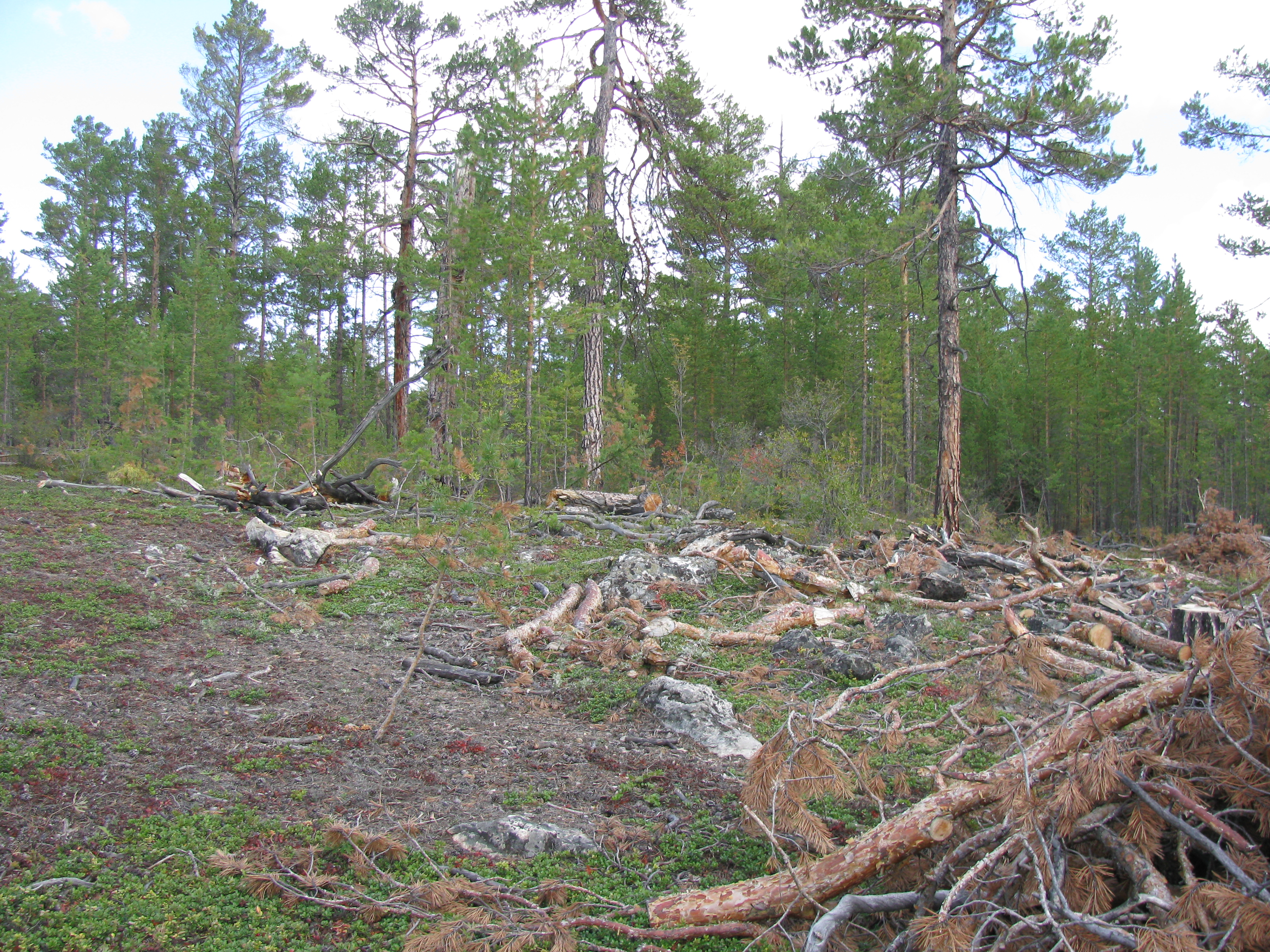
Another ecological concern affecting the island is the illegal felling of timber
Lumber is wood that has been processed into dimensional lumber, including beams and planks or boards, a stage in the process of wood production. Lumber is mainly used for construction framing, as well as finishing (floors, wall panels, w ...
by local inhabitants. A complicated net of forestry roads in the areas adjacent to Khuzhir leads to woodland areas on the mountain slopes. Timber is brought out of the forest at night time, and the deforestation
Deforestation or forest clearance is the removal of a forest or stand of trees from land that is then converted to non-forest use. Deforestation can involve conversion of forest land to farms, ranches, or urban use. The most concentrated ...
is taking its toll on the area.
See also
*List of islands of Russia
A ''list'' is any set of items in a row. List or lists may also refer to:
People
* List (surname)
Organizations
* List College, an undergraduate division of the Jewish Theological Seminary of America
* SC Germania List, German rugby unio ...
*
*
References
External links
Photogallery of Olkhon island
Eduard Y. Osipov ., Oleg M. Khlystov. Glaciers and meltwater flux to Lake Baikal during the Last Glacial Maximum // Palaeogeography, Palaeoclimatology, Palaeoecology 294 (2010) 4–15.
{{Authority control Landforms of Irkutsk Oblast Islands of Lake Baikal Dunes of Russia