Nieuwe Maas on:
[Wikipedia]
[Google]
[Amazon]
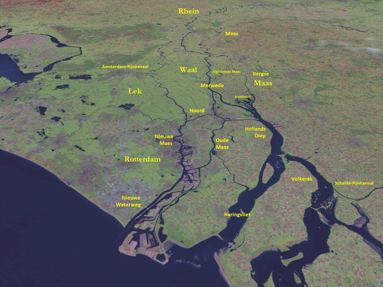
The Nieuwe Maas (; "New Meuse") is a

 From west to east:
* Beneluxtunnel (tunnel; motor vehicles, cyclists and metro)
* Maastunnel (tunnel; motor vehicles, cyclists, pedestrians)
* Erasmusbrug (bridge; motor vehicles, cyclists, pedestrians, trams)
* Maastaxi (ferry; pedestrians)
* Metrotunnel (tunnel; metro)
* Willemstunnel (tunnel; train)
*
distributary
A distributary, or a distributary channel, is a stream that branches off and flows away from a main stream channel. Distributaries are a common feature of river deltas. The phenomenon is known as river bifurcation. The opposite of a distributar ...
of the Rhine
), Surselva, Graubünden, Switzerland
, source1_coordinates=
, source1_elevation =
, source2 = Rein Posteriur/Hinterrhein
, source2_location = Paradies Glacier, Graubünden, Switzerland
, source2_coordinates=
, source ...
River, and a former distributary of the Maas River, in the Dutch province
A province is almost always an administrative division within a country or state. The term derives from the ancient Roman ''provincia'', which was the major territorial and administrative unit of the Roman Empire's territorial possessions out ...
of South Holland
South Holland ( nl, Zuid-Holland ) is a province of the Netherlands with a population of over 3.7 million as of October 2021 and a population density of about , making it the country's most populous province and one of the world's most densely ...
. It runs from the confluence of the rivers Noord and Lek, and flows west through Rotterdam
Rotterdam ( , , , lit. ''The Dam on the River Rotte (river), Rotte'') is the second largest List of cities in the Netherlands by province, city and List of municipalities of the Netherlands, municipality in the Netherlands. It is in the Prov ...
. It ends west of the city where it meets the Oude Maas
The Oude Maas (; en, Old Meuse) is a distributary of the river Rhine, and a former distributary of the river Maas, in the Dutch province of South Holland. It begins at the city of Dordrecht where the Beneden Merwede river splits into the Noo ...
("Old Meuse"), near Vlaardingen
Vlaardingen () is a city in South Holland in the Netherlands. It is located on the north bank of the Nieuwe Maas river at the confluence with the Oude Maas. The municipality administers an area of , of which is land, with residents in .
Geog ...
, to form Het Scheur. After a few miles, the Scheur continues as the artificial Nieuwe Waterweg. The total length of the Nieuwe Maas (excluding the Scheur) is approximately .
Geography
The Nieuwe Maas flows through some of the most densely populated and developed areas in the Netherlands. Along its shores are numerous harbours and industries.History
During the earlyMiddle Ages
In the history of Europe, the Middle Ages or medieval period lasted approximately from the late 5th to the late 15th centuries, similar to the post-classical period of global history. It began with the fall of the Western Roman Empire ...
the river was considered to be the continuation of the Merwede river (itself a distributary branch of the Rhine
), Surselva, Graubünden, Switzerland
, source1_coordinates=
, source1_elevation =
, source2 = Rein Posteriur/Hinterrhein
, source2_location = Paradies Glacier, Graubünden, Switzerland
, source2_coordinates=
, source ...
) and was named accordingly. However, during the 13th century a series of floods forced the Maas to shift its main course north towards the Merwede. From then on, several stretches of the original Merwede were named Maas instead, including the current Nieuwe Maas.
In the late 19th century the connection between the Maas and Rhine was closed off entirely (the current Afgedamde Maas) and the Maas was given a new, artificial mouth - the Bergse Maas. The resulting separation of the rivers Rhine and Maas reduced the risk of flooding and is considered to be the greatest achievement in Dutch hydraulic engineering before the completion of the Zuiderzee Works
The Zuiderzee Works ( nl, Zuiderzeewerken) is a man-made system of dams and dikes, land reclamation and water drainage work, in total the largest hydraulic engineering project undertaken by the Netherlands during the twentieth century. The proj ...
and Delta Works. From that moment on, the Nieuwe Maas is only fed by the Rhine.
River crossings

 From west to east:
* Beneluxtunnel (tunnel; motor vehicles, cyclists and metro)
* Maastunnel (tunnel; motor vehicles, cyclists, pedestrians)
* Erasmusbrug (bridge; motor vehicles, cyclists, pedestrians, trams)
* Maastaxi (ferry; pedestrians)
* Metrotunnel (tunnel; metro)
* Willemstunnel (tunnel; train)
*
 Willemsbrug
The Willemsbrug (English: "Williams Bridge") is a bridge next to the Erasmusbrug in the centre of Rotterdam, Netherlands, spanning the Nieuwe Maas. It links the northern part of the city with the ''Noordereiland
Noordereiland is a neighborhood ...
(bridge; motor vehicles, cyclists, pedestrians)
* Van Brienenoordbrug (bridge; motor vehicles, cyclists, pedestrians)
References
{{Rhine–Meuse–Scheldt delta Rivers of the Rhine–Meuse–Scheldt delta Geography of Rotterdam Rivers of South Holland Distributaries of Europe IJsselmonde (island) Rivers of the Netherlands