Myola on:
[Wikipedia]
[Google]
[Amazon]
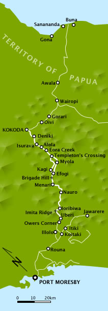
 Myola is a locality on the
 Myola is a locality on the
 Kokoda Track
The Kokoda Track or Trail is a single-file foot thoroughfare that runs overland – in a straight line – through the Owen Stanley Range in Papua New Guinea (PNG). The track was the location of the 1942 World War II battle between Japanes ...
in the Territory of Papua
The Territory of Papua comprised the southeastern quarter of the island of New Guinea from 1883 to 1975. In 1883, the Government of Queensland annexed this territory for the British Empire. The United Kingdom Government refused to ratify the a ...
and the modern state of New Guinea
New Guinea (; Hiri Motu: ''Niu Gini''; id, Papua, or , historically ) is the world's second-largest island with an area of . Located in Oceania in the southwestern Pacific Ocean, the island is separated from Australia by the wide Torr ...
. It is one of two closely located dry lake beds located near where the Kokoda Track crosses the crest of the Owen Stanley Range – also known as "the Gap" or "the Kokoda Gap". Myola, the smaller of the two lake beds, was located and named by Lieutenant Bert Kienzle on 3 August 1943. It became a major resupply point and drop zone for Australian forces during the Kokoda Track campaign
The Kokoda Track campaign or Kokoda Trail campaign was part of the Pacific War of World War II. The campaign consisted of a series of battles fought between July and November 1942 in what was then the Australian Territory of Papua. It was primar ...
. Kienzle then cut a track toward Eora Creek which rejoined the original track at Templeton's Crossing, which he also named.
Myola was named (there being no local name) for the wife of his friend and commanding officer, Major Sydney Elliot-Smith. Myola is an Australian aboriginal word meaning "dawn of day". The second, larger lake bed to the immediate north is referred to as Myola 2, with the smaller lake bed being sometimes known as Myola 1. Myola 2 was developed as the major resupply point as the Australian forces advanced, following the Japanese forces as they withdrew from Ioribaiwa Ridge back toward Kokoda. A strip was developed at Myola 2, being a larger area but it was considered too risky for general use. Major General George Vasey landed at Myola 2 when he relieved Major General Arthur Allen on 28 October 1942.
References
;Notes ;Citations ;Bibliography * * * * * * * {{cite book, last=McCarthy, first=Dudley, title=South-West Pacific Area – First Year, series=Australia in the War of 1939–1945. Series 1 – Army, volume=5, publisher=Australian War Memorial, location=Canberra, Australian Capital Territory, year=1959, url=https://www.awm.gov.au/collection/RCDIG1070204/, oclc=3134247 Territory of Papua