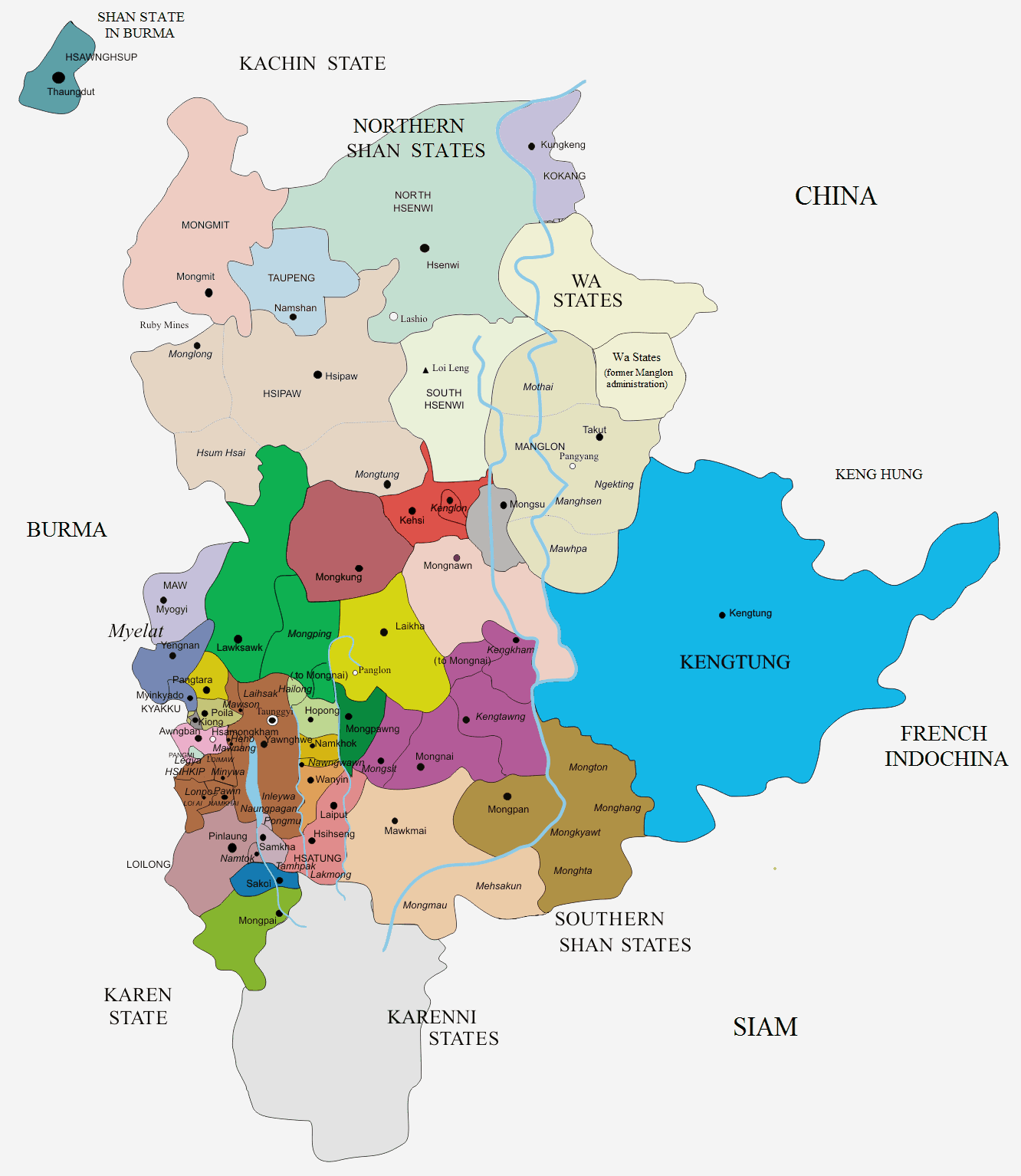
Mongpan State on:
[Wikipedia]
[Google]
[Amazon]
 Mongpan (also spelt Möngpan), also known as Maingpan ( my, မိုင်းပန်) was a Shan state in what is today
/ref>
"Gazetteer of Upper Burma and the Shan states"The Imperial Gazetteer of India
* Shan States {{ShanState-geo-stub ca:Mongpan
 Mongpan (also spelt Möngpan), also known as Maingpan ( my, မိုင်းပန်) was a Shan state in what is today
 Burma
Myanmar, ; UK pronunciations: US pronunciations incl. . Note: Wikipedia's IPA conventions require indicating /r/ even in British English although only some British English speakers pronounce r at the end of syllables. As John Wells explai ...
. It belonged to the Eastern Division of the Southern Shan States
The Shan States (1885–1948) were a collection of minor Shan kingdoms called ''muang'' whose rulers bore the title ''saopha'' in British Burma. They were analogous to the princely states of British India.
The term "Shan States" was firs ...
.
The town of Mong Pan
Mong Pan or ဝဵင်းမိူင်းပၼ်ႇ is a town and seat of Mong Pan Township in the southern Shan State of Burma. To the south it borders Mae Hong Son Province in Thailand and lies west of the Salween River. It lies along N ...
was formerly the residence of the Sawbwa
Chao-Pha (; Tai Ahom: 𑜋𑜧𑜨 𑜇𑜡, th, เจ้าฟ้า}, shn, ၸဝ်ႈၾႃႉ, translit=Jao3 Fa5 Jao3 Fa5, my, စော်ဘွား ''Sawbwa,'' ) was a royal title used by the hereditary rulers of the Tai peoples of ...
of Mongpan State. The capital is in the middle of a fertile plain. Most of the other areas of the state are mountainous, rich in teak
Teak (''Tectona grandis'') is a tropical hardwood tree species in the family Lamiaceae. It is a large, deciduous tree that occurs in mixed hardwood forests. ''Tectona grandis'' has small, fragrant white flowers arranged in dense clusters (panicl ...
forests. Loi Hkilek
Loi Hkilek or Loi Kyi-lek is a mountain of the Shan Hills, in Shan State, Burma.GoogleEarth
Geography
Loi Hkilek is located about 11 km to the northeast of Möng Kyawt (Mongkyawt) in Mong Ton Township of Mongsat District.
Although this mou ...
, a 2,133 high mountain is located in Mongkyawt District.Imperial Gazetteer of India, v. 17, p. 407/ref>
History
According to legend there had been a predecessor state. Mongpan state was founded in 1637, but little is known of the history of the state before the times of British Burma. The four districts of Mongtang, Monghang, Mongkyawt and Monghta, located east of theSalween
, ''Mae Nam Salawin'' (
, name_etymology =
, image = Sweet_View_of_Salween_River_in_Tang_Yan_Township,_Shan_State,_Myanmar.jpg
, image_size =
, image_caption = Salween River in Shan State, Myanmar
, map ...
were historically claimed by Siam
Thailand ( ), historically known as Siam () and officially the Kingdom of Thailand, is a country in Southeast Asia, located at the centre of the Mainland Southeast Asia, Indochinese Peninsula, spanning , with a population of almost 70 mi ...
, but the British upheld the view that they belonged to the Cis-Salween Sawbwa of Mongpan.
In 1888 Siamese troops were posted in the four trans-Salween districts; Siam also claimed a further district, Monghsat, but posted no troops there.
In 1889 the British formed the 1889-90 Anglo-Siamese Boundary Commission, in order to solve the difficulties with Siam concerning the trans-Salween dependencies of Mawkmai, Mongpan, and Karenni
Karenni may refer to:
* Karenni people
* Karenni language
* Karenni State, former name of Kayah State, Myanmar
* Karenni States
The Karenni States, also known as Red Karen States, was the name formerly given to the states inhabited mainly by ...
. This commission however, would not be successful for Siam declined to join it at the last moment. Nevertheless, the commission went ahead despite the lack of agreement from the Siamese government and brought about the partition of these tracts and their incorporation into British Burma. British troops forced the Siamese garrisons to withdraw from the territories of the trans-Salween that were deemed not to belong to Siam. Finally the demarcation of the new frontier was carried out by the joint 1892-3 Anglo-Siamese Boundary Commission.
Between December 1943 and 1945 the occupying Japanese allowed the government of Siam
Thailand ( ), historically known as Siam () and officially the Kingdom of Thailand, is a country in Southeast Asia, located at the centre of the Mainland Southeast Asia, Indochinese Peninsula, spanning , with a population of almost 70 mi ...
to annex all four districts of Mongpan State east of the Salween as part of the Saharat Thai Doem
Saharat Thai Doem ( th, สหรัฐไทยเดิม, lit=Unified Former Thai Territories) was an administrative division of Thailand. It encompassed parts of the Shan States of British Burma annexed by the Thai government after the Jap ...
territory —together with Kengtung State.Rulers
The rulers of Mongpan bore the title of ''Saopha
Chao-Pha (; Ahom language, Tai Ahom: 𑜋𑜧𑜨 𑜇𑜡, th, เจ้าฟ้า}, shn, ၸဝ်ႈၾႃႉ, translit=Jao3 Fa5 Jao3 Fa5, my, စော်ဘွား ''Sawbwa,'' ) was a royal title used by the hereditary rulers of the T ...
'' after 1867; their ritual style was ''Kambawsa Mahawuntha Thirdamaraza''. Myozas
*1637 - .... Tawk La *.... - .... Twak Hkam *.... - .... Twak Twe *.... - .... Op La *.... - .... Hkun Som *.... - .... Shwe Tong *.... - .... Sai U *.... - .... Sai Nyo *.... - 1809 Naw Hkam (d. 1809) *1809 - 1823 Mana Ne Myo (d. 1823) *1823 - 1858 Maung Shwe Hkam (d. 1858) *1858 - 1867 Hkun Tun U (d. 1886)Saophas
*1867 - 1886 Hkun Tun U (s.a.) *1886 - 1918 Hkun Num Leng (b. 1869 - d. 1918) *1918 - 1952 Hkun OnSee also
* Anglo-Siamese Treaty of 1909References
External links
"Gazetteer of Upper Burma and the Shan states"
* Shan States {{ShanState-geo-stub ca:Mongpan