Melville Peninsula on:
[Wikipedia]
[Google]
[Amazon]

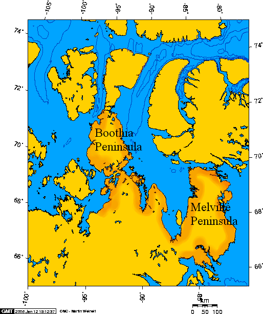
 Melville Peninsula is a large peninsula in the Canadian

Arctic
The Arctic ( or ) is a polar region located at the northernmost part of Earth. The Arctic consists of the Arctic Ocean, adjacent seas, and parts of Canada (Yukon, Northwest Territories, Nunavut), Danish Realm (Greenland), Finland, Iceland, N ...
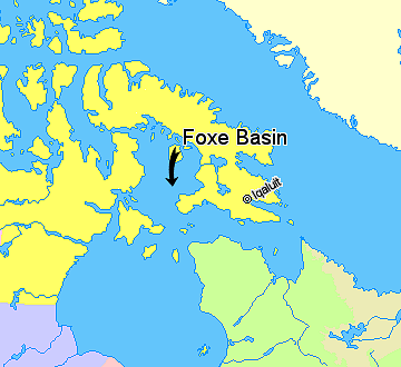
north of Hudson Bay. To the east is Foxe Basin
Foxe Basin is a shallow oceanic basin north of Hudson Bay, in Nunavut, Canada, located between Baffin Island and the Melville Peninsula. For most of the year, it is blocked by sea ice (fast ice) and drift ice made up of multiple ice floes.
...
and to the west the Gulf of Boothia
The Gulf of Boothia is a body of water in Nunavut, Canada. Administratively it is divided between the Kitikmeot Region on the west and the Qikiqtaaluk Region on the east. It merges north into Prince Regent Inlet, the two forming a single bay w ...
. To the north the Fury and Hecla Strait
Fury and Hecla Strait is a narrow (from wide) Arctic seawater channel located in the Qikiqtaaluk Region of Nunavut, Canada.
Geography
Situated between Baffin Island to the north and the Melville Peninsula to the south, it connects Foxe Basin o ...
separates it from Baffin Island. To the south Repulse Bay
Repulse Bay or Tsin Shui Wan is a bay in the southern part of Hong Kong Island, located in the Southern District, Hong Kong. It is one of the most expensive residential areas in the world.
Geography
Repulse Bay is located in the southern ...
and Frozen Strait
Frozen Strait is a waterway in Nunavut just north of Hudson Bay between the Melville Peninsula to the north and Southampton Island to the south. It connects Repulse Bay to the west with Foxe Basin to the east. The strait is long, and 19 to 32 km ...
separate it from Southampton Island
Southampton Island (Inuktitut: ''Shugliaq'') is a large island at the entrance to Hudson Bay at Foxe Basin. One of the larger members of the Arctic Archipelago, Southampton Island is part of the Kivalliq Region in Nunavut, Canada. The area of th ...
at the north end of Hudson Bay. On the southwest it is connected to the mainland by the Rae Isthmus, named after the Arctic explorer John Rae.
Between 1821 and 1823 its east side was mapped by William Edward Parry
Sir William Edward Parry (19 December 1790 – 8 July 1855) was an Royal Navy officer and explorer best known for his 1819–1820 expedition through the Parry Channel, probably the most successful in the long quest for the Northwest Pass ...
, who named the peninsula (along with Melville Island) after Robert Dundas, 2nd Viscount Melville
Robert Dundas, 2nd Viscount Melville (14 March 1771 – 10 June 1851) was a British statesman, the son of Henry Dundas, the 1st Viscount. Dundas was the Member of Parliament for Hastings in 1794, Rye in 1796 and Midlothian in 1801. He was als ...
First Sea Lord of the Admirality. Since 1999, it has been part of Nunavut. Before that, it was part of the District of Franklin. Most of the peninsula lies in Nunavut's Qikiqtaaluk Region, while its southwesternmost section, around Repulse Bay, lies in the Kivalliq Region
The Kivalliq Region (; Inuktitut syllabics: ᑭᕙᓪᓕᖅ ) is an administrative region of Nunavut, Canada. It consists of the portion of the mainland to the west of Hudson Bay together with Southampton Island and Coats Island. The regional c ...
. Communities on the peninsula include the hamlets of Naujaat
Naujaat ( iu, ᓇᐅᔮᑦ, lit=seagulls' nesting place), known until 2 July 2015 as Repulse Bay, is an Inuit hamlet situated on the Arctic Circle. It is located on the shores of Hudson Bay, at the south end of the Melville Peninsula, in the ...
and Sanirajak
Sanirajak (Inuktitut meaning ''the shoreline''), Syllabics: ᓴᓂᕋᔭᒃ), formerly known as Hall Beach until 27 February 2020, is an Inuit settlement within the Qikiqtaaluk Region of Nunavut, Canada, approximately south of Igloolik.
Histo ...
. The hamlet of Igloolik is located on an island lying just off the northeastern coast of the peninsula. Adjoining Igloolik is Igloolik Airport.
References
Further reading
* Bolton, Thomas Elwood. ''Geology of Ordovician rocks, Melville Peninsula and region, southeastern district of Franklin''. Ottawa: Energy, Mines and Resources Canada, 1977. * Dredge, Lynda A. 2000. "Age and Origin of Upland Block Fields on Melville Peninsula, Eastern Canadian Arctic". ''Geografiska Annaler
''Geografiska Annaler'' is a scientific journal published by the Swedish Society for Anthropology and Geography in Stockholm, Sweden. The journal is founded in 1919. Since 1965 the journal is published in two series A and B. Series A deals with arc ...
Series A: Physical Geography''. 82, no. 4: 443–454.
* Dredge, L. A. ''Quaternary Geology of Southern Melville Peninsula, Nunavut Surface Deposits, Glacial History, Environmental Geology, and Till Geochemistry''. Ottawa: Geological Survey of Canada, 2002.
* Frisch, T. ''Precambrian Geology of the Prince Albert Hills, Western Melville Peninsula, Northwest Territories''. Ottawa, Canada: Geological Survey of Canada, 1982.
* Henderson, J. R. ''Structure and Metamorphism of the Aphebian Penrhyn Group and Its Archean Basement Complex in the Lyon Inlet Area, Melville Peninsula, District of Franklin''. Ottawa, Ont., Canada: Geological Survey of Canada, 1983.
* Mathiassen, Therkel, and Peter Freuchen. ''Contributions to the Geography of Baffin Land and Melville Peninsula''. Copenhagen: Gyldendalske Boghandel, 1933.
* Schau, Mikkel. ''Geology of the Archean Prince Albert Group in the Richards Bay Area, Northeastern Melville Peninsula, District of Franklin, Northwest Territories''. Ottawa: Geological Survey of Canada, 1997.
Peninsulas of Qikiqtaaluk Region
{{QikiqtaalukNU-geo-stub