Erdapfel on:
[Wikipedia]
[Google]
[Amazon]


 __NOTOC__
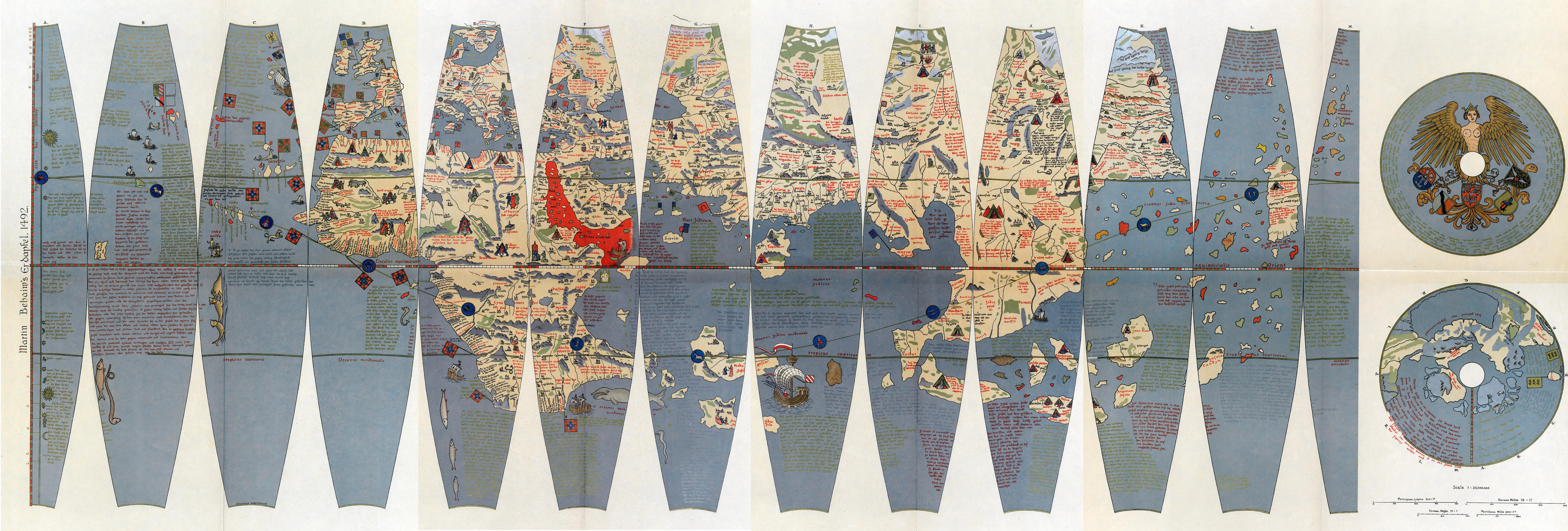
The (; ) is a terrestrial
 Digitalisierung durch das Germanische Nationalmuseum Nürnberg
Terrestrial globes are known to have been made from antiquity, such as The Globe of Crates. None are known to have survived, even as fragments. A celestial globe, the
The International Coronelli Society for the Study of Globes
{{Authority control Historic maps of the world Collections of the Germanisches Nationalmuseum 1492 works 15th-century maps and globes


 __NOTOC__
The (; ) is a terrestrial
 globe
A globe is a spherical model of Earth, of some other celestial body, or of the celestial sphere. Globes serve purposes similar to maps, but unlike maps, they do not distort the surface that they portray except to scale it down. A model glo ...
produced by Martin Behaim
Martin Behaim (6 October 1459 – 29 July 1507), also known as and by various forms of , was a German textile merchant and cartographer. He served John II of Portugal as an adviser in matters of navigation and participated in a voyage to W ...
from 1490–1492. The Erdapfel is the oldest surviving terrestrial globe. It is constructed of a laminated linen ball in two halves, reinforced with wood and overlaid with a map
A map is a symbolic depiction emphasizing relationships between elements of some space, such as objects, regions, or themes.
Many maps are static, fixed to paper or some other durable medium, while others are dynamic or interactive. Although ...
painted on gores by Georg Glockendon
Georg Glockendon the Elder (fl. 1484; died 1514) was a Nuremberg-based woodblock cutter, printer and painter. Famed during his lifetime for his illuminations, he was also an industrious printer and published a number of the works of Erhard Etzlau ...
. The map was drawn on paper, which was pasted on a layer of parchment around the globe.
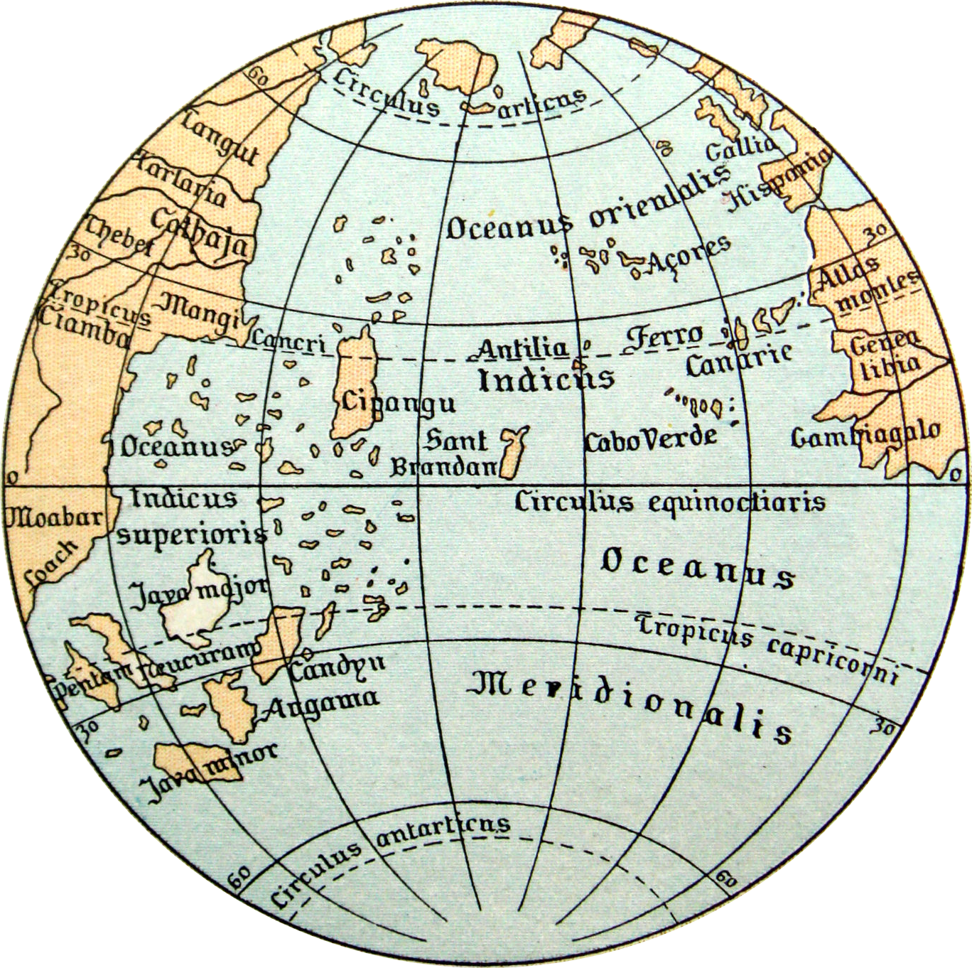
The Americas are not included, as Columbus returned to Spain no sooner than March 1493. The globe shows an enlarged Eurasian continent and an empty ocean between Europe and Asia. The mythical Saint Brendan's Island is included. Cipangu ( Japan) is oversized and well south of its true position; Martellus's map is followed in developing an enormous phantom peninsula east of the Golden Chersonese (Malaysia
Malaysia ( ; ) is a country in Southeast Asia. The federation, federal constitutional monarchy consists of States and federal territories of Malaysia, thirteen states and three federal territories, separated by the South China Sea into two r ...
).
The idea to call the globe "apple" may be related to the Reichsapfel ("Imperial Apple", Globus cruciger) which was also kept in Nuremberg along with the Imperial Regalia
The Imperial Regalia, also called Imperial Insignia (in German ''Reichskleinodien'', ''Reichsinsignien'' or ''Reichsschatz''), are regalia of the Holy Roman Emperor. The most important parts are the Crown, the Imperial orb, the Imperial sc ...
( Reichskleinodien). The name is not related to the modern meaning of Erdapfel in southern Germany and Austria, which is "potato
The potato is a starchy food, a tuber of the plant ''Solanum tuberosum'' and is a root vegetable native to the Americas. The plant is a perennial in the nightshade family Solanaceae.
Wild potato species can be found from the southern Unit ...
"—potatoes had not yet been brought from America to Europe.
From its creation until early in the 16th century, it stood in a reception room in the Nuremberg town hall. After that time, it was held by the Behaim family. In 1907, it was transferred to the Germanic Museum in Nuremberg
Nuremberg ( ; german: link=no, Nürnberg ; in the local East Franconian dialect: ''Nämberch'' ) is the second-largest city of the German state of Bavaria after its capital Munich, and its 518,370 (2019) inhabitants make it the 14th-largest ...
. In 1992, it was moved for some time to the Vienna University of Technology
TU Wien (TUW; german: Technische Universität Wien; still known in English as the Vienna University of Technology from 1975–2014) is one of the major universities in Vienna, Austria. The university finds high international and domestic recogn ...
, to be studied at high resolution by the Behaim Digital Globe Project. In 2011, a second digitalization by the German National Museum began.Terrestrial globes are known to have been made from antiquity, such as The Globe of Crates. None are known to have survived, even as fragments. A celestial globe, the
Farnese Atlas
The Farnese Atlas is a 2nd-century AD Roman marble sculpture of Atlas holding up a celestial globe. Probably a copy of an earlier work of the Hellenistic period, it is the oldest extant statue of Atlas, a Titan of Greek mythology who is repres ...
, has survived from the second century AD.
See also
*Early world maps
The earliest known world maps date to classical antiquity, the oldest examples of the 6th to 5th centuries BCE still based on the flat Earth paradigm.
World maps assuming a spherical Earth first appear in the Hellenistic period.
The developments ...
* Lenox Globe
* Ostrich Egg Globe
References
Further reading
*External links
The International Coronelli Society for the Study of Globes
{{Authority control Historic maps of the world Collections of the Germanisches Nationalmuseum 1492 works 15th-century maps and globes