El Malpais National Monument on:
[Wikipedia]
[Google]
[Amazon]
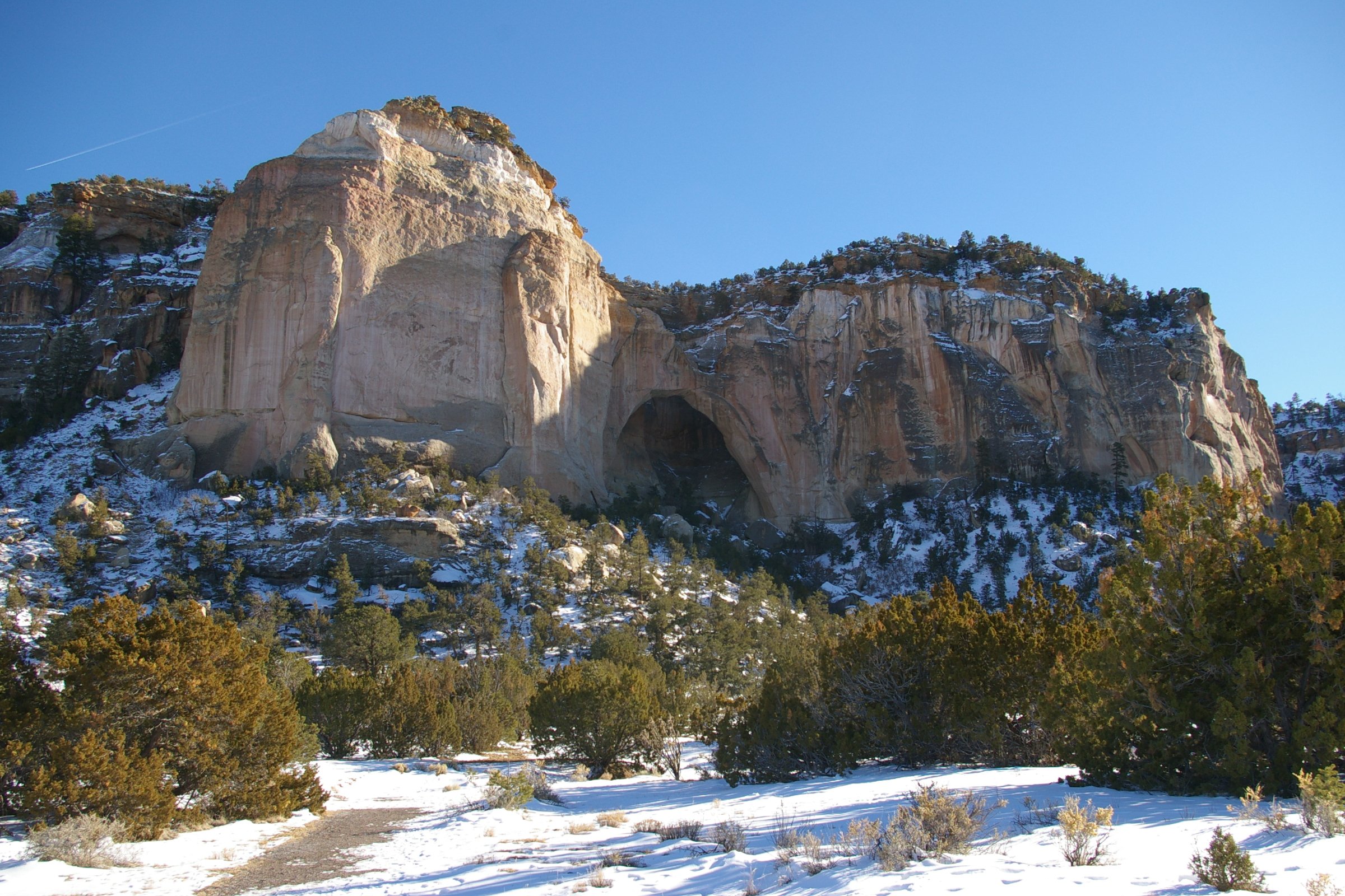
El Malpais National Monument is a
New Mexico Tourism Department. Retrieved August 14, 2014.
 The lava flows, cinder cones, and other volcanic features of El Malpais are part of the
 El Malpais has many
 The U.S.
BLM: El Malpais National Conservation Area website
TopoQuest USGS Quad Map
{{authority control Malpaíses (landform) National Park Service National Monuments in New Mexico Caves of New Mexico Lava tubes Natural arches of New Mexico Volcanic fields of New Mexico Protected areas established in 1987 Archaeological sites in New Mexico Pre-Columbian cultural areas Great Divide of North America Protected areas of Cibola County, New Mexico Landforms of Cibola County, New Mexico 1987 establishments in New Mexico Lava fields Badlands of the United States
National Monument
A national monument is a monument constructed in order to commemorate something of importance to national heritage, such as a country's founding, independence, war, or the life and death of a historical figure.
The term may also refer to a spe ...
located in western New Mexico
)
, population_demonym = New Mexican ( es, Neomexicano, Neomejicano, Nuevo Mexicano)
, seat = Santa Fe, New Mexico, Santa Fe
, LargestCity = Albuquerque, New Mexico, Albuquerque
, LargestMetro = Albuquerque metropolitan area, Tiguex
, Offi ...
, in the Southwestern United States
The Southwestern United States, also known as the American Southwest or simply the Southwest, is a geographic and cultural region of the United States that generally includes Arizona, New Mexico, and adjacent portions of California, Colorado, N ...
. The name El Malpais is from the Spanish term '' Malpaís'', meaning ''badlands
Badlands are a type of dry terrain where softer sedimentary rocks and clay-rich soils have been extensively eroded."Badlands" in ''Chambers's Encyclopædia''. London: George Newnes, 1961, Vol. 2, p. 47. They are characterized by steep slopes, mi ...
'', due to the extremely barren and dramatic volcanic field
A volcanic field is an area of Earth's crust that is prone to localized volcanic activity. The type and number of volcanoes required to be called a "field" is not well-defined. Volcanic fields usually consist of clusters of up to 100 volcanoes ...
that covers much of the park's area.
It is on the Trails of the Ancients Byway, one of the designated New Mexico Scenic Byways.Trail of the Ancients.New Mexico Tourism Department. Retrieved August 14, 2014.
Geography and geology
Zuni-Bandera volcanic field
Zuni-Bandera volcanic field (also known as Bandera lava field, Grants Malpais and Malpais volcanic field) is a volcanic field located in the state of New Mexico, United States.
The volcanic field has been considered for geothermal exploitation ...
, the second largest volcanic field in the Basin and Range Province
The Basin and Range Province is a vast physiographic region covering much of the inland Western United States and northwestern Mexico. It is defined by unique basin and range topography, characterized by abrupt changes in elevation, alternating ...
. This volcanically active area on the southeast margin of the Colorado Plateau
The Colorado Plateau, also known as the Colorado Plateau Province, is a physiographic and desert region of the Intermontane Plateaus, roughly centered on the Four Corners region of the southwestern United States. This province covers an area o ...
is located on the ancient Jemez Lineament
The Jemez Lineament is a chain of late Cenozoic volcanic fields, long, reaching from the Springerville and White Mountains volcanic fields in East-Central Arizona to the Raton-Clayton volcanic field in Northeastern New Mexico.
The lineament ...
, which provides the crustal weakness that recent magmatic intrusions and Cenozoic volcanism are attributed to.
The rugged pahoēhoē and ʻaʻā lava
Lava is molten or partially molten rock (magma) that has been expelled from the interior of a terrestrial planet (such as Earth) or a moon onto its surface. Lava may be erupted at a volcano or through a fracture in the crust, on land or ...
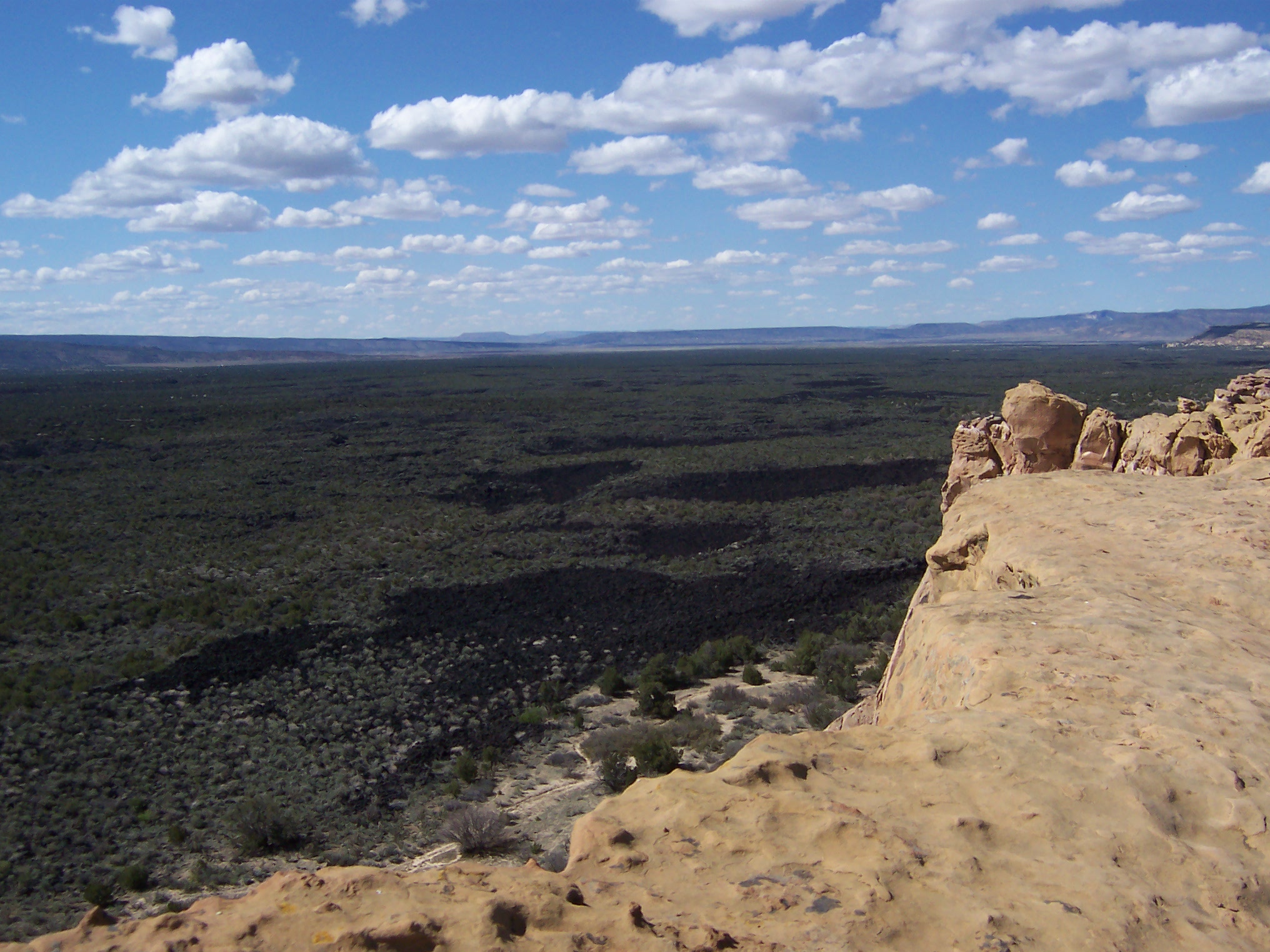
flows of the Zuni-Bandera eruptions (also called the Grants Lava Flows) filled a large basin, created by normal faulting associated with the Rio Grande Rift, between the high mesas of the Acoma Pueblo to the east, Mt. Taylor to the north, and the Zuni Mountain anticline to the northwest. Vents associated with these flows include Bandera Crater, El Calderon, and several other cinder cones; more than a dozen older cinder cones follow a roughly north-south distribution along the Chain of Craters west of the monument.
Features
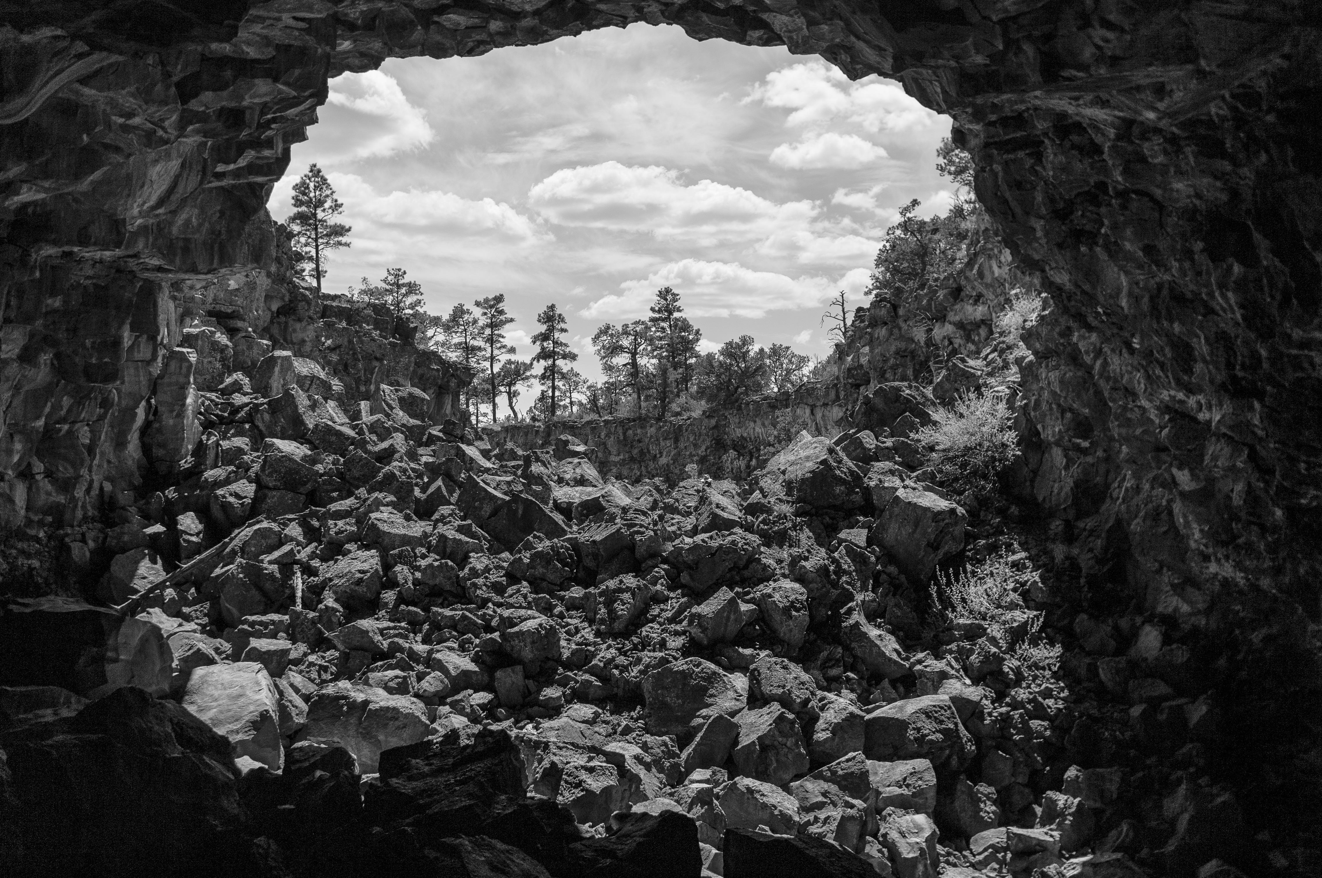
 El Malpais has many
 lava tube
A lava tube, or pyroduct, is a natural conduit formed by flowing lava from a volcanic vent that moves beneath the hardened surface of a lava flow. If lava in the tube empties, it will leave a cave.
Formation
A lava tube is a type of lava ...
s open to explore (unguided) with a free caving permit, available at NPS-staffed facilities. There are currently four caves accessible by permit: Junction and Xenolith caves in the El Caldron area, and Big Skylight and Giant Ice caves in the Big Tubes area. From December 2010 to June 2013, all caves were temporarily closed to recreational use to protect bats from the spread of White Nose Syndrome (WNS) until a permitting process, including visitor screening for WNS, could be implemented.
A nearby scenic overlook at Sandstone Bluffs offers spectacular panoramic views over the monument's lava flows.
Natural history
Some of the oldest Rocky Mountain Douglas-firs (''Pseudotsuga menziesii subsp. glauca'') on Earth can be found living in El Malpais Monument. In 2020, a new population ofhart's-tongue fern
''Asplenium scolopendrium'', commonly known as the hart's-tongue fern, is an evergreen fern in the genus ''Asplenium'' native to the Northern Hemisphere.
Description
The most striking and unusual feature of the fern is its simple, undivided f ...
s (''Asplenium scolopendrium'') was discovered inside of a cave with basaltic lava flows in El Malpais, which represents the first confirmed population of the species in the United States
The United States of America (U.S.A. or USA), commonly known as the United States (U.S. or US) or America, is a country Continental United States, primarily located in North America. It consists of 50 U.S. state, states, a Washington, D.C., ...
or Canada
Canada is a country in North America. Its ten provinces and three territories extend from the Atlantic Ocean to the Pacific Ocean and northward into the Arctic Ocean, covering over , making it the world's second-largest country by to ...
west of the Mississippi; all other known populations of the fern are around the Great Lakes
The Great Lakes, also called the Great Lakes of North America, are a series of large interconnected freshwater lakes in the mid-east region of North America that connect to the Atlantic Ocean via the Saint Lawrence River. There are five lakes ...
, Alabama
(We dare defend our rights)
, anthem = " Alabama"
, image_map = Alabama in United States.svg
, seat = Montgomery
, LargestCity = Huntsville
, LargestCounty = Baldwin County
, LargestMetro = Greater Birmingham
, area_total_km2 = 135,7 ...
, and Tennessee
Tennessee ( , ), officially the State of Tennessee, is a landlocked U.S. state, state in the Southeastern United States, Southeastern region of the United States. Tennessee is the List of U.S. states and territories by area, 36th-largest by ...
. Genetic analyses and surveys are currently being performed to determine the population's variation and overall health.
History
The area around El Malpais was used for resources, settlement, and travel by Oasisamerica cultures, Native Americans, and Spanish colonial and pioneer exploration. Archaeological sites remain in the park. In the 1940s the Malpais lava field was one of the eight candidate sites considered by theManhattan Project
The Manhattan Project was a research and development undertaking during World War II that produced the first nuclear weapons. It was led by the United States with the support of the United Kingdom and Canada. From 1942 to 1946, the project w ...
to test detonate the first atomic bomb
A nuclear weapon is an explosive device that derives its destructive force from nuclear reactions, either fission (fission bomb) or a combination of fission and fusion reactions ( thermonuclear bomb), producing a nuclear explosion. Both bomb ...
, the Trinity nuclear test, which did occur to the south at White Sands Proving Ground. The Department of Defense did use the site as a bombing range to train pilots during World War II.
After the war, the Bureau of Land Management became the administrator of the area. In 1987, President Reagan signed that created El Malpais National Monument and designated it a unit of the National Park Service. It is jointly managed with the nearby El Morro National Monument.
Protection and management
 The U.S.
 National Park Service
The National Park Service (NPS) is an agency of the United States federal government within the U.S. Department of the Interior that manages all national parks, most national monuments, and other natural, historical, and recreational properti ...
protects, manages, and interprets El Malpais National Monument. El Malpais Visitor Center (formerly The Northwest New Mexico Visitor Center) is just south of Exit 85 off I-40 in Grants, New Mexico.
The adjacent El Malpais National Conservation Area
The El Malpais National Conservation Area is a federally protected conservation area in the U.S. state of New Mexico. The El Malpais National Conservation area was established in 1987 and is managed by the Bureau of Land Management as part of ...
is protected and managed by the U.S. Bureau of Land Management
The Bureau of Land Management (BLM) is an agency within the United States Department of the Interior responsible for administering federal lands. Headquartered in Washington DC, and with oversight over , it governs one eighth of the country's ...
. They staff the El Malpais National Conservation Area Ranger Station 8 miles down State Highway 117 south of I-40 Exit 89.
The Cibola National Forest conserves large natural areas, wildlife, and habitat
In ecology, the term habitat summarises the array of resources, physical and biotic factors that are present in an area, such as to support the survival and reproduction of a particular species. A species habitat can be seen as the physical ...
s in the surrounding region as well.
In literature
The second portion of the book ''Brave New World
''Brave New World'' is a dystopian novel by English author Aldous Huxley, written in 1931 and published in 1932. Largely set in a futuristic World State, whose citizens are environmentally engineered into an intelligence-based social hiera ...
'' by Aldous Huxley
Aldous Leonard Huxley (26 July 1894 – 22 November 1963) was an English writer and philosopher. He wrote nearly 50 books, both novels and non-fiction works, as well as wide-ranging essays, narratives, and poems.
Born into the prominent Huxle ...
takes place on the "savage reservation", which is located on land encompassing the park's area.
The ''malpais'' is the setting for a western story, "Flint" (November, 1960) by Louis L'Amour
Louis Dearborn L'Amour (; né LaMoore; March 22, 1908 – June 10, 1988) was an American novelist and short story writer. His books consisted primarily of Western novels (though he called his work "frontier stories"); however, he also wrote hi ...
. Flint is a successful business man who thinks he is dying of cancer and returns to a hidden campsite within the ''malpais'' he had learned of in his youth.
A scene in Cormac McCarthy
Cormac McCarthy (born Charles Joseph McCarthy Jr., July 20, 1933) is an American writer who has written twelve novels, two plays, five screenplays and three short stories, spanning the Western and post-apocalyptic genres. He is known for his g ...
's novel ''Blood Meridian
''Blood Meridian or the Evening Redness in the West'' is a 1985 in literature, 1985 Epic (genre), epic novel by American author Cormac McCarthy, classified under the Western (genre), Western, or sometimes the Revisionist Western, anti-Western, g ...
'' takes place on the malpais.
References
Further reading
*External links
BLM: El Malpais National Conservation Area website
TopoQuest USGS Quad Map
{{authority control Malpaíses (landform) National Park Service National Monuments in New Mexico Caves of New Mexico Lava tubes Natural arches of New Mexico Volcanic fields of New Mexico Protected areas established in 1987 Archaeological sites in New Mexico Pre-Columbian cultural areas Great Divide of North America Protected areas of Cibola County, New Mexico Landforms of Cibola County, New Mexico 1987 establishments in New Mexico Lava fields Badlands of the United States