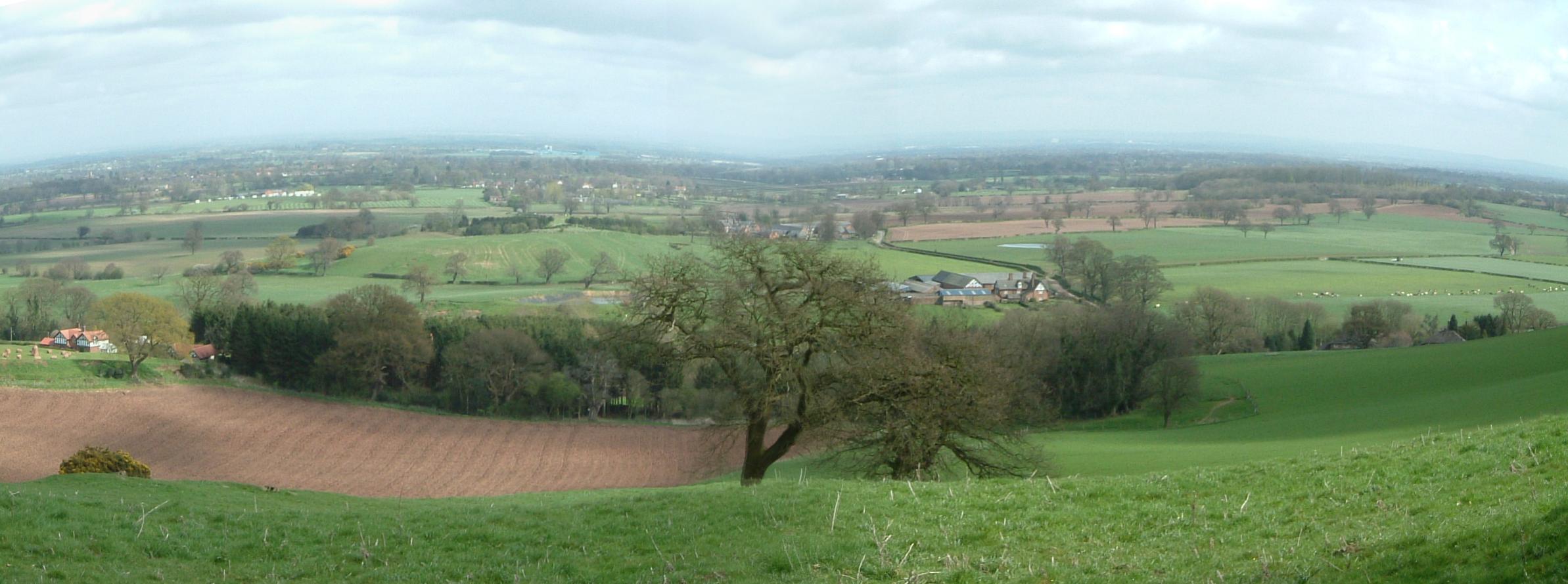
Cheshire Plain on:
[Wikipedia]
[Google]
[Amazon]
 The Cheshire Plain is a relatively flat expanse of
 The Cheshire Plain is a relatively flat expanse of
 lowland
Upland and lowland are conditional descriptions of a plain based on elevation above sea level. In studies of the ecology of freshwater rivers, habitats are classified as upland or lowland.
Definitions
Upland and lowland are portions of p ...
within the county of Cheshire in North West England but extending south into Shropshire. It extends from the Mersey Valley in the north to the Shropshire Hills
The Shropshire Hills are a dissected upland area and one of the natural regions of England. They lie wholly within the county of Shropshire and encompass several distinctive and well-known landmarks, such as the Long Mynd, Wenlock Edge, The W ...
in the south, bounded by the hills of North Wales
North Wales ( cy, Gogledd Cymru) is a region of Wales, encompassing its northernmost areas. It borders Mid Wales to the south, England to the east, and the Irish Sea to the north and west. The area is highly mountainous and rural, with Snowdonia N ...
to the west and the foothills of the Pennines to the north-east. The Wirral Peninsula
Wirral (; ), known locally as The Wirral, is a peninsula in North West England. The roughly rectangular peninsula is about long and wide and is bounded by the River Dee to the west (forming the boundary with Wales), the River Mersey to ...
lies to the north-west whilst the plain merges with the South Lancashire Plain in the embayment occupied by Manchester
Manchester () is a city in Greater Manchester, England. It had a population of 552,000 in 2021. It is bordered by the Cheshire Plain to the south, the Pennines to the north and east, and the neighbouring city of Salford to the west. The t ...
to the north. In detail, the plain comprises two areas with distinct characters, the one to the west of the Mid Cheshire Ridge
The Mid Cheshire Ridge is a range of low sandstone hills which stretch north to south through Cheshire in North West England. The ridge is discontinuous, with the hills forming two main blocks, north and south of the "Beeston Gap". The main mas ...
and the other, larger part, to its east.
The plain is the surface expression of the Cheshire Basin
The Cheshire Basin is a late Palaeozoic and Mesozoic sedimentary basin extending under most of the county of Cheshire in northwest England. It extends northwards into the Manchester area and south into Shropshire. The basin possesses something of t ...
, a deep sedimentary basin
Sedimentary basins are region-scale depressions of the Earth's crust where subsidence has occurred and a thick sequence of sediments have accumulated to form a large three-dimensional body of sedimentary rock. They form when long-term subside ...
that extends north into Lancashire
Lancashire ( , ; abbreviated Lancs) is the name of a historic county, ceremonial county, and non-metropolitan county in North West England. The boundaries of these three areas differ significantly.
The non-metropolitan county of Lancash ...
and south into Shropshire
Shropshire (; alternatively Salop; abbreviated in print only as Shrops; demonym Salopian ) is a landlocked historic county in the West Midlands region of England. It is bordered by Wales to the west and the English counties of Cheshire to ...
. It assumed its current form as the ice-sheets of the last glacial period melted away between 20,000 and 15,000 years ago leaving behind a thick cover of glacial till
image:Geschiebemergel.JPG, Closeup of glacial till. Note that the larger grains (pebbles and gravel) in the till are completely surrounded by the matrix of finer material (silt and sand), and this characteristic, known as ''matrix support'', is d ...
and extensive tracts of glacio-fluvial sand and gravel.
The primary agricultural use of the Cheshire Plain is dairy farming
Dairy farming is a class of agriculture for long-term production of milk, which is processed (either on the farm or at a dairy plant, either of which may be called a dairy) for eventual sale of a dairy product. Dairy farming has a history th ...
, creating the general appearance of enclosed hedgerow fields.
Meteorologists use the term Cheshire Gap when referring to the lowlands of the Cheshire Plain, providing as they do a passage between the Clwydian Hills, in Wales on the one hand and the Peak District
The Peak District is an upland area in England at the southern end of the Pennines. Mostly in Derbyshire, it extends into Cheshire, Greater Manchester, Staffordshire, West Yorkshire and South Yorkshire. It includes the Dark Peak, where moorla ...
and South Pennines on the other. Weather systems are often guided down this "gap", penetrating much further inland than elsewhere along the coast of the Irish Sea
The Irish Sea or , gv, Y Keayn Yernagh, sco, Erse Sie, gd, Muir Èireann , Ulster-Scots: ''Airish Sea'', cy, Môr Iwerddon . is an extensive body of water that separates the islands of Ireland and Great Britain. It is linked to the Ce ...
.
See also
*Geology of Cheshire
The geology of Cheshire in England consists mainly of Triassic sandstones and mudstones. To the north west of Cheshire, these rocks are heavily faulted and the underlying Carboniferous Coal Measures are thrown up. Around the areas of Poynton a ...
*Geology of Alderley Edge
One of the classic locations for the study of Triassic sandstones in the UK is at Alderley Edge in Cheshire. Numerous scientists from the early 19th century up to the present day have studied the area and it is a popular field site for universit ...
References
Geology of Cheshire Valleys of Cheshire Plains of England {{Cheshire-geo-stub