Bottomless Lakes State Park on:
[Wikipedia]
[Google]
[Amazon]
Bottomless Lakes State Park is a state park in the


Bottomless Lakes State Park
{{authority control State parks of New Mexico Parks in Chaves County, New Mexico Protected areas established in 1933 1933 establishments in New Mexico Sinkholes of the United States Landforms of Chaves County, New Mexico Landforms of New Mexico Bodies of water of Chaves County, New Mexico Lakes of New Mexico Ramsar sites in the United States
U.S. state
In the United States, a state is a constituent political entity, of which there are 50. Bound together in a political union, each state holds governmental jurisdiction over a separate and defined geographic territory where it shares its sove ...
of New Mexico
)
, population_demonym = New Mexican ( es, Neomexicano, Neomejicano, Nuevo Mexicano)
, seat = Santa Fe
, LargestCity = Albuquerque
, LargestMetro = Tiguex
, OfficialLang = None
, Languages = English, Spanish ( New Mexican), Navajo, Ke ...
, located along the Pecos River, about southeast of Roswell. Established in 1933, it was the first state park in New Mexico. It takes its name from nine small, deep lakes located along the eastern escarpment
An escarpment is a steep slope or long cliff that forms as a result of faulting or erosion and separates two relatively level areas having different elevations.
The terms ''scarp'' and ''scarp face'' are often used interchangeably with ''esca ...
of the Pecos River valley
A valley is an elongated low area often running between hills or mountains, which will typically contain a river or stream running from one end to the other. Most valleys are formed by erosion of the land surface by rivers or streams ove ...
.
Lakes
Most of the nine lakes are almost completely surrounded by cliffs, with the notable exceptions being Lea Lake and Lazy Lagoon. Lea Lake has a large, sandy shoreline on the western side and tall cliffs on the eastern side. The cliffs around Lazy Lagoon have been completely eroded away by the Pecos River, and the lake sits in a former channel of the river. Lazy Lagoon is the largest of the lakes, with a surface area of approximately . Although it is a single lake, it is made up of three separatesinkholes
A sinkhole is a depression or hole in the ground caused by some form of collapse of the surface layer. The term is sometimes used to refer to doline, enclosed depressions that are locally also known as ''vrtače'' and shakeholes, and to openi ...
. The surface of the Lazy Lagoon is nearly level with the surrounding salt flats, which makes it look very shallow. Despite the name, the deepest of its three sinkholes is deep.
Lea Lake is the only lake in which swimming is allowed. It has a beach and concession area that is popular in the summer.
Devil's Inkwell is the smallest lake with a surface area of . Its name stems from the water's dark color, caused by the steep sides of the cenote
A cenote ( or ; ) is a natural pit cave, pit, or sinkhole, resulting from the collapse of limestone bedrock that exposes groundwater. The regional term is specifically associated with the Yucatán Peninsula of Mexico, where cenotes were commonly ...
and algae growth within the lake.
In pure geologic terms, Figure Eight Lake is two lakes separated by a thin strip of land. When the water is very high the strip of land is covered, and the two nearly circular lakes join and take the shape of a figure eight. Irrigation
Irrigation (also referred to as watering) is the practice of applying controlled amounts of water to land to help grow crops, landscape plants, and lawns. Irrigation has been a key aspect of agriculture for over 5,000 years and has been devel ...
in the Pecos Valley has lowered the water table, so the two lakes of Figure Eight lake rarely join to form a single lake anymore.
Pasture Lake is the shallowest lake at deep with a surface area of .
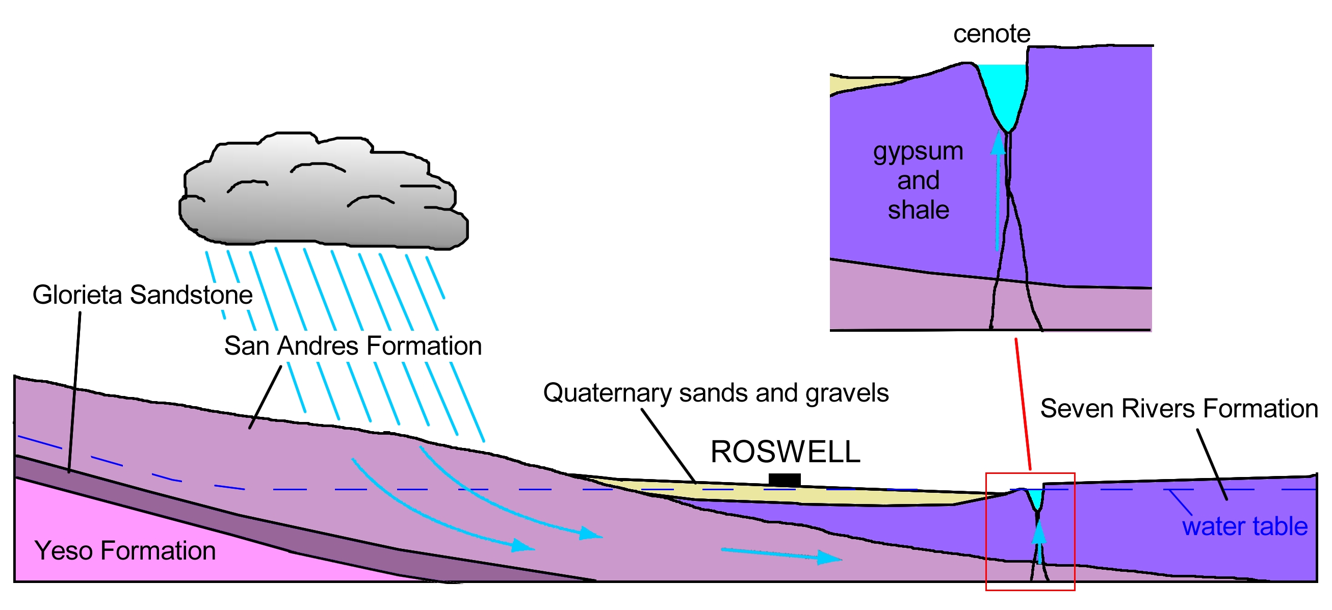
The lakes are not fed by streams, and the evaporation rate of the lakes in the hot desert climate exceeds the rate at which rain
Rain is water droplets that have condensed from atmospheric water vapor and then fall under gravity. Rain is a major component of the water cycle and is responsible for depositing most of the fresh water on the Earth. It provides water ...
water refills them. The lakes are fed by underground water
Groundwater is the water present beneath Earth's surface in rock and soil pore spaces and in the fractures of rock formations. About 30 percent of all readily available freshwater in the world is groundwater. A unit of rock or an unconsolidate ...
percolating through the rocks and into the lakes. The high evaporation rate produces brackish water
Brackish water, sometimes termed brack water, is water occurring in a natural environment that has more salinity than freshwater, but not as much as seawater. It may result from mixing seawater (salt water) and fresh water together, as in estuari ...
in the lakes.
Seven of the lakes are protected, although in recent years the lakes have been contaminated by trash that has been thrown into the lakes by careless visitors. The ninth and southernmost lake, Dimmitt Lake, is not a part of the state park and is owned by the Fin and Feather Club, a local hunting and fishing club
Origin of the lakes
The Bottomless Lakes occur at the base of an escarpment formed by the gypsum-rich Seven Rivers Formation. Ground water in the underlying San Andres artisan aquifer rises along faults at the escarpment and dissolves the gypsum thereby creating sinkholes orcenotes
A cenote ( or ; ) is a natural pit, or sinkhole, resulting from the collapse of limestone bedrock that exposes groundwater. The regional term is specifically associated with the Yucatán Peninsula of Mexico, where cenotes were commonly used ...
.


Wildlife
Four endangered species can be found in the park—thePecos pupfish
The Pecos pupfish (''Cyprinodon pecosensis'') is a species of pupfish in the family Cyprinodontidae. It is endemic to the Pecos River watershed in eastern New Mexico and western Texas in the United States.
Distribution and Habitat
Despite once ...
, the Rainwater Killifish
A killifish is any of various oviparous (egg-laying) cyprinodontiform fish (including families Aplocheilidae, Cyprinodontidae, Fundulidae, Profundulidae and Valenciidae). All together, there are 1,270 species of killifish, the biggest family ...
, the cricket frog, and the Eastern Barking Frog.
In the winter, Devil's Inkwell and Cottonwood Lake are both stocked with Rainbow Trout.
See also
* List of sinkholes of the United States *TheBlue Hole
A blue hole is a large marine cavern or sinkhole, which is open to the surface and has developed in a bank or island composed of a carbonate bedrock ( limestone or coral reef). Their existence was discovered in the late 20th century by fishe ...
, a similar waterbody also in New Mexico
References
External links
Bottomless Lakes State Park
{{authority control State parks of New Mexico Parks in Chaves County, New Mexico Protected areas established in 1933 1933 establishments in New Mexico Sinkholes of the United States Landforms of Chaves County, New Mexico Landforms of New Mexico Bodies of water of Chaves County, New Mexico Lakes of New Mexico Ramsar sites in the United States