Blackmore Vale on:
[Wikipedia]
[Google]
[Amazon]

 The Blackmore Vale (; less commonly spelt ''Blackmoor'') is a

 The Blackmore Vale (; less commonly spelt ''Blackmoor'') is a
 vale
A vale is a type of valley.
Vale may also refer to:
Places Georgia
* Vale, Georgia, a town in the Samtskhe-Javakheti region
Norway
* Våle, a historic municipality
Portugal
* Vale (Santa Maria da Feira), a former civil parish in the municipa ...
, or wide valley
A valley is an elongated low area often running between hills or mountains, which will typically contain a river or stream running from one end to the other. Most valleys are formed by erosion of the land surface by rivers or streams ove ...
, in north Dorset
North Dorset was a local government district in Dorset, England. It was largely rural, but included the towns of Blandford Forum, Gillingham, Shaftesbury, Stalbridge and Sturminster Newton. Much of North Dorset was in the River Stour v ...
, and to a lesser extent south Somerset
South Somerset is a local government district in Somerset, England.
The South Somerset district covers an area of ranging from the borders with Devon, Wiltshire and Dorset to the edge of the Somerset Levels. It has a population of approxim ...
and southwest Wiltshire
Wiltshire (; abbreviated Wilts) is a historic and ceremonial county in South West England with an area of . It is landlocked and borders the counties of Dorset to the southwest, Somerset to the west, Hampshire to the southeast, Gloucestershire ...
in southern England
England is a country that is part of the United Kingdom. It shares land borders with Wales to its west and Scotland to its north. The Irish Sea lies northwest and the Celtic Sea to the southwest. It is separated from continental Europe ...
.
Geography
The vale is part of the Stour valley, part of theDorset AONB
Dorset (or archaically, Dorsetshire) is a county in South West England on the English Channel coast. Covering an area of ; it borders Devon to the west, Somerset to the north-west, Wiltshire to the north-east, and Hampshire to the east. The grea ...
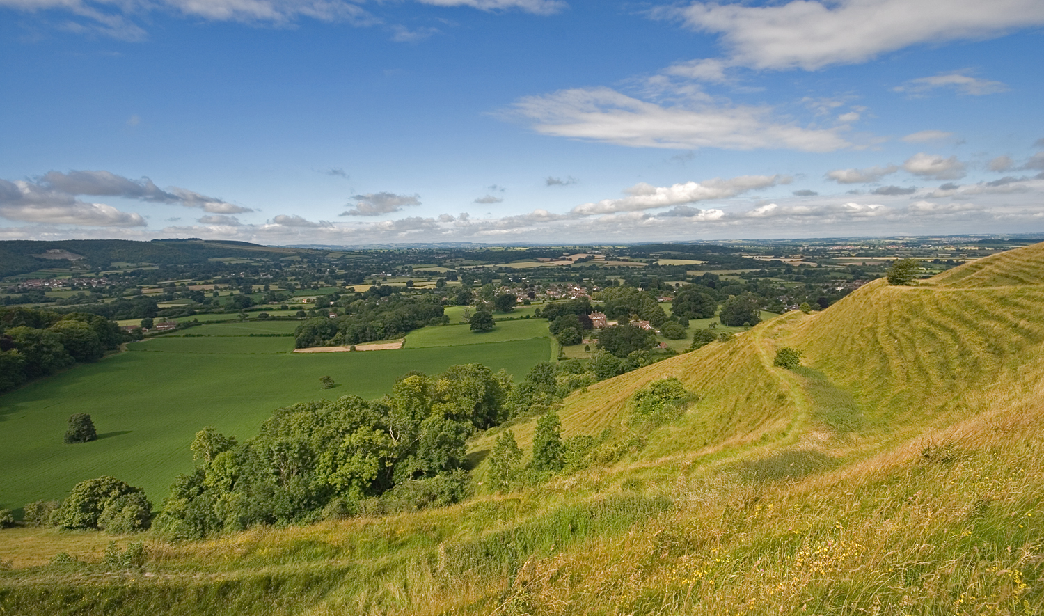
and part of the natural region known as the Blackmoor Vale and Vale of Wardour. To the south and east, the vale is clearly delimited by the steep escarpment
An escarpment is a steep slope or long cliff that forms as a result of faulting or erosion and separates two relatively level areas having different elevations.
The terms ''scarp'' and ''scarp face'' are often used interchangeably with ''esca ...
s of two areas of higher chalk downland, the Dorset Downs to the south, and Cranborne Chase
Cranborne Chase () is an area of central southern England, straddling the counties Dorset, Hampshire and Wiltshire. It is part of the Cranborne Chase and West Wiltshire Downs Area of Outstanding Natural Beauty (AONB).
The area is dominated by ...
to the east. To the north and west, the definitions of the vale are more ambiguous, as the landscape changes more gradually around the upper reaches of the Stour and its tributaries. One definition places the boundary along the watershed between the Stour and neighbouring valleys of the Yeo to the west and Brue
Brue ( gd, Brù) is a village on the Isle of Lewis in the West Side district, in the Outer Hebrides, Scotland. It is a crofting township and it is composed of two areas: Am Baile Staigh, which is nearer the coast, and Pàirc Bhrù, which runs t ...
to the north. A narrower definition places the limits of the vale close to the county boundary and villages like Bourton, where the landscape transitions to hillier greensand, limestone and sandstone geology. In her book on the Blackmore Vale, Hilary Townsend described the northern boundary as "above Gillingham, through Motcombe to Queen Oak and Bourton, then crosses the A303, ignores the A30 and slips down on winding country roads past Bow Brook and Gibbs Marsh towards Sherborne"; while she placed the western boundary outside the Stour watershed "south of Sherborne down Dancing Hill, across the A352 and pick up the line of the River Yeo towards Beer Hackett, Yetminster and Chetnole".
The River Stour flows out of the vale at Blandford Forum
Blandford Forum ( ), commonly Blandford, is a market town in Dorset, England, sited by the River Stour about northwest of Poole. It was the administrative headquarters of North Dorset District until April 2019, when this was abolished and it ...
in the southeast, a town sandwiched between the Dorset Downs and Cranborne Chase.
When viewed from above (e.g. from the chalk escarpments) the vale appears quite uniform - a large expanse of green, lush, low-lying land - but in geological terms it comprises alternating belts of different clay and limestone soils (and greensand at the foot of the chalk), which give rise to subtle variations in topography and appearance, and which affect land use. The majority of human settlements are built on the drier strips of limestone, whereas the more poorly draining clays (which comprise the greater bulk of the area) are more sparsely populated, supporting mostly small farms, dotted across the vale. Due to the clay soils, land use is predominantly dairy farming. Until it was closed in 1998, Sturminster Newton livestock market was the busiest weekly livestock market in Britain.
Cultural associations
The vale, in particular the village ofMarnhull
Marnhull ( ) is a village and civil parish in the county of Dorset in southern England. It lies in the Blackmore Vale, north of Sturminster Newton. The resort towns of Bournemouth and Weymouth are approximately south. Marnhull is sited on a l ...
("Marlott"), is the opening backdrop for Thomas Hardy
Thomas Hardy (2 June 1840 – 11 January 1928) was an English novelist and poet. A Victorian realist in the tradition of George Eliot, he was influenced both in his novels and in his poetry by Romanticism, including the poetry of William Wor ...
's '' Tess of the D'Urbervilles''; he also lived and wrote in Sturminster Newton for a time. William Barnes
William Barnes (22 February 1801 – 7 October 1886) was an English polymath, writer, poet, philologist, priest, mathematician, engraving artist and inventor. He wrote over 800 poems, some in Dorset dialect, and much other work, including a co ...
the poet also lived in Sturminster Newton. Douglas Adams
Douglas Noel Adams (11 March 1952 – 11 May 2001) was an English author and screenwriter, best known for ''The Hitchhiker's Guide to the Galaxy''. Originally a 1978 The Hitchhiker's Guide to the Galaxy (radio series), BBC radio comedy, ''The H ...
and Robert Boyle
Robert Boyle (; 25 January 1627 – 31 December 1691) was an Anglo-Irish natural philosopher, chemist, physicist, alchemist and inventor. Boyle is largely regarded today as the first modern chemist, and therefore one of the founders ...
lived in Stalbridge for part of their lives.
Towns and villages
Settlements in the vale include: *Belchalwell
Belchalwell is a small village in the civil parish of Okeford Fitzpaine in the Blackmore Vale, North Dorset, England. It lies south of Sturminster Newton and northwest of Blandford Forum. Belchalwell Street is sited on Upper Greensand, with L ...
* Bourton
* Child Okeford
Child Okeford (sometimes written Childe Okeford) is a village and civil parish in the county of Dorset in southern England, east of the small town of Sturminster Newton in the North Dorset administrative district. Child Okeford lies downstream ...
* East Stour
* Gillingham
* Hazelbury Bryan
Hazelbury Bryan is a village and civil parish in the county of Dorset in southern England. It is situated in the Blackmore Vale, approximately southwest of the small town of Sturminster Newton. The parish includes the hamlets of Droop, Kingsto ...
* Henstridge
* Hinton St Mary
* Horsington
* Marnhull
Marnhull ( ) is a village and civil parish in the county of Dorset in southern England. It lies in the Blackmore Vale, north of Sturminster Newton. The resort towns of Bournemouth and Weymouth are approximately south. Marnhull is sited on a l ...
* Mere
* Motcombe
Motcombe is a village and civil parish in north Dorset, England. It lies about north of Shaftesbury. It is sited on Kimmeridge clay soil beneath hills at the edge of the Blackmore Vale. The parish is one of the largest in Dorset. In the 20 ...
* Okeford Fitzpaine
* Shillingstone
Shillingstone is a village and civil parish in the Blackmore Vale area of north Dorset, England, situated on the River Stour between Sturminster Newton and Blandford Forum. In the 2011 Census the civil parish had 479 households and a popu ...
* Stalbridge
* Stour Provost
* Stourton Caundle
Stourton Caundle is a village and civil parish in the county of Dorset in southwest England. It lies within the Blackmore Vale, about east of Sherborne. In the 2011 census the parish had 181 households and a population of 439.
Stourton Caun ...
* Sturminster Newton
* Templecombe
Templecombe is a village in Somerset, England, situated on the A357 road five miles south of Wincanton, east of Yeovil, and west of Salisbury. The village has a population of 1,560. Along with the hamlet of Combe Throop, it forms the parish o ...
* Todber
Todber is a village and civil parish in the county of Dorset in southern England. It lies in the Blackmore Vale, about southwest of Shaftesbury. The underlying geology is Corallian limestone. In the 2011 census the parish had 55 households ...
* West Stour
* Shaftesbury
Shaftesbury () is a town and civil parish in Dorset, England. It is situated on the A30 road, west of Salisbury, near the border with Wiltshire. It is the only significant hilltop settlement in Dorset, being built about above sea level on a ...
, Sherborne
Sherborne is a market town and civil parish in north west Dorset, in South West England. It is sited on the River Yeo, on the edge of the Blackmore Vale, east of Yeovil. The parish includes the hamlets of Nether Coombe and Lower Clatcombe. ...
and Wincanton are on the edges of the vale, but not actually in it.
References
External links
{{Authority control Valleys of Somerset Valleys of Dorset Natural regions of Dorset