Bahram Vallis on:
[Wikipedia]
[Google]
[Amazon]
 Bahram Vallis is an ancient river valley in the
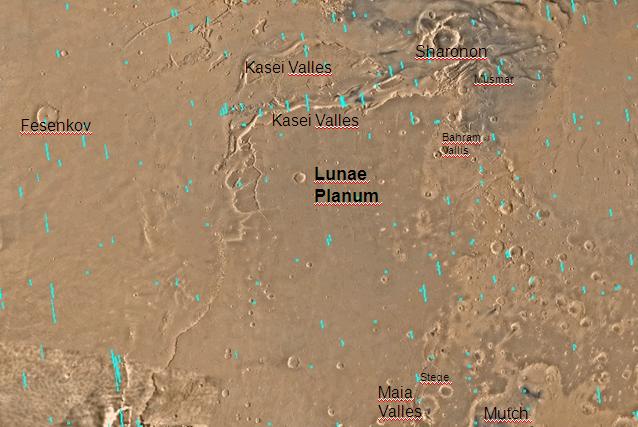
Image:Kasei Valles topolabled.JPG, Area around Northern Kasei Valles, showing relationships among
Lunae Palus quadrangle
The Lunae Palus quadrangle is one of a series of 30 quadrangle maps of Mars used by the United States Geological Survey (USGS) Astrogeology Research Program. The quadrangle is also referred to as MC-10 (Mars Chart-10). Lunae Planum and parts o ...
of Mars
Mars is the fourth planet from the Sun and the second-smallest planet in the Solar System, only being larger than Mercury. In the English language, Mars is named for the Roman god of war. Mars is a terrestrial planet with a thin at ...
at 20.7° north latitude and 57.5° west longitude. It is about 302 km long and was named after the word for 'Mars' in Persian. Bahram Vallis is located midway between Vedra Valles and lower Kasei Valles
The Kasei Valles are a giant system of canyons in Mare Acidalium and Lunae Palus quadrangles on Mars, centered at 24.6° north latitude and 65.0° west longitude. They are long and were named for the word for "Mars" in Japanese. This is one ...
. It is basically a single trunk valley, with scalloped walls in some places. The presence of streamlined erosional features on its floor shows that fluid was involved with its formation.Baker, V. 1982. The Channels of Mars. University of Texas Press. Austin
Kasei Valles
The Kasei Valles are a giant system of canyons in Mare Acidalium and Lunae Palus quadrangles on Mars, centered at 24.6° north latitude and 65.0° west longitude. They are long and were named for the word for "Mars" in Japanese. This is one ...
, Bahram Vallis, Vedra Valles, Maumee Valles, and Maja Valles
The Maja Valles are a large system of ancient outflow channels in the Lunae Palus quadrangle on Mars. Their location is 12.6° north latitude and 58.3° west longitude. The name is a Nepali word for "Mars". The Maja Valles begin at Juventae Chasma. ...
. Map location is in Lunae Palus quadrangle
The Lunae Palus quadrangle is one of a series of 30 quadrangle maps of Mars used by the United States Geological Survey (USGS) Astrogeology Research Program. The quadrangle is also referred to as MC-10 (Mars Chart-10). Lunae Planum and parts o ...
and includes parts of Lunae Planum and Chryse Planitia.
Image:Bahram Vallis.JPG, Bahram Vallis, as seen by HiRISE. Rotational landslides (slumps) are visible at the base of north wall.
File:ESP 056904 2015valley.jpg, Close view of part of Bahram Vallis, as seen by HiRISE under HiWish program
References
See also
*Geology of Mars
The geology of Mars is the scientific study of the surface, crust, and interior of the planet Mars. It emphasizes the composition, structure, history, and physical processes that shape the planet. It is analogous to the field of terrestrial g ...
* HiRISE
* Lunae Palus quadrangle
The Lunae Palus quadrangle is one of a series of 30 quadrangle maps of Mars used by the United States Geological Survey (USGS) Astrogeology Research Program. The quadrangle is also referred to as MC-10 (Mars Chart-10). Lunae Planum and parts o ...
* Outflow channels
Valleys and canyons on Mars
Lunae Palus quadrangle
{{Mars-stub