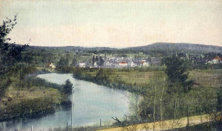
Ashuelot River on:
[Wikipedia]
[Google]
[Amazon]
The Ashuelot River is a tributary of the Connecticut River, approximately long, in southwestern
 From source to mouth:
*Cherry Brook (headwaters of the Ashuelot)
*Butler Brook
*Abbott Brook
*Grassy Brook
*Dart Brook
*Thompson Brook
* The Branch/Beaver Brook
*Ash Swamp Brook
* South Branch Ashuelot River
*California Brook
*Wheelock Brook
* Mirey Brook
*Broad Brook
Keene, NH: Ashuelot River ParkAtlas of the Ashuelot River
(PDF) {{authority control Rivers of New Hampshire Tributaries of the Connecticut River Rivers of Cheshire County, New Hampshire Rivers of Sullivan County, New Hampshire New Hampshire placenames of Native American origin
New Hampshire
New Hampshire is a state in the New England region of the northeastern United States. It is bordered by Massachusetts to the south, Vermont to the west, Maine and the Gulf of Maine to the east, and the Canadian province of Quebec to the nor ...
in the United States
The United States of America (U.S.A. or USA), commonly known as the United States (U.S. or US) or America, is a country primarily located in North America. It consists of 50 states, a federal district, five major unincorporated territori ...
. It drains a mountainous area of , including much of the area known as the Monadnock Region
The Monadnock Region is a region in southwestern New Hampshire. It is named after Mount Monadnock, a 3,165 foot isolated mountain, which is the dominant geographic landmark in the region. Although it has no specific borders, the Monadnock Region i ...
. It is the longest tributary of the Connecticut River within New Hampshire.
Etymology
''Ashuelot'' is a Native American word meaning "collection of many waters".Course
The Ashuelot River rises out of Butterfield Pond south of Sunapee Mountain in Pillsbury State Park, nearWashington
Washington commonly refers to:
* Washington (state), United States
* Washington, D.C., the capital of the United States
** A metonym for the federal government of the United States
** Washington metropolitan area, the metropolitan area centered o ...
in southeastern Sullivan County. It flows southwest through Ashuelot Pond
Ashuelot Pond is a New Hampshire GRANIT state geographic information system
water body ...
into Cheshire County, then south past Keene and Swanzey and along the east side of the Pisgah Mountains. At Winchester, approximately from the water body ...
Massachusetts
Massachusetts (Massachusett: ''Muhsachuweesut Massachusett_writing_systems.html" ;"title="nowiki/> məhswatʃəwiːsət.html" ;"title="Massachusett writing systems">məhswatʃəwiːsət">Massachusett writing systems">məhswatʃəwiːsət'' En ...
state line, it turns west, flowing past the village of Ashuelot and joining the Connecticut from the east at Hinsdale, in the extreme southwest corner of New Hampshire.
The river is impounded to supply hydroelectricity
Hydroelectricity, or hydroelectric power, is electricity generated from hydropower (water power). Hydropower supplies one sixth of the world's electricity, almost 4500 TWh in 2020, which is more than all other renewable sources combined an ...
at Marlow, Keene, Swanzey, and Hinsdale. The river is part of the Atlantic Salmon Restoration Program
The Atlantic Ocean is the second-largest of the world's five oceans, with an area of about . It covers approximately 20% of Earth's surface and about 29% of its water surface area. It is known to separate the "Old World" of Africa, Europe and ...
of the U.S. government.
Covered bridges
The Ashuelot River has several covered bridges spanning its waters. All are listed on theNational Register of Historic Places
The National Register of Historic Places (NRHP) is the United States federal government's official list of districts, sites, buildings, structures and objects deemed worthy of preservation for their historical significance or "great artistic ...
. From source to mouth:
* Carleton Bridge N.H. #7 - Swanzey ( South Branch Ashuelot River)
* Sawyers Crossing Covered Bridge N.H. #6 - Swanzey
* West Swanzey Covered Bridge N.H. #5 - West Swanzey
* Slate Covered Bridge N.H. #4 - Swanzey
* Coombs Covered Bridge N.H. #2 - Winchester
* Ashuelot Covered Bridge N.H. #1 - Ashuelot
Selected tributaries
 From source to mouth:
*Cherry Brook (headwaters of the Ashuelot)
*Butler Brook
*Abbott Brook
*Grassy Brook
*Dart Brook
*Thompson Brook
* The Branch/Beaver Brook
*Ash Swamp Brook
* South Branch Ashuelot River
*California Brook
*Wheelock Brook
* Mirey Brook
*Broad Brook
See also
* List of New Hampshire riversReferences
External links
Keene, NH: Ashuelot River Park
(PDF) {{authority control Rivers of New Hampshire Tributaries of the Connecticut River Rivers of Cheshire County, New Hampshire Rivers of Sullivan County, New Hampshire New Hampshire placenames of Native American origin