34th meridian west from Washington on:
[Wikipedia]
[Google]
[Amazon]
 The 34th meridian west from Washington is an archaic
 The 34th meridian west from Washington is an archaic
 meridian
Meridian or a meridian line (from Latin ''meridies'' via Old French ''meridiane'', meaning “midday”) may refer to
Science
* Meridian (astronomy), imaginary circle in a plane perpendicular to the planes of the celestial equator and horizon
* ...
based on the Washington Meridian
The Washington meridians are four meridians that were used as prime meridians in the United States and pass through Washington, D.C. The four which have been specified are:
# through the Capitol
# through the White House
# through the old Naval Ob ...
and hence 111°2′48.0″ West of Greenwich. The meridian is most notably used as a boundary for four states. The east-west continental divide of North America crosses the 34th meridian at the tripoint
A tripoint, trijunction, triple point, or tri-border area is a geographical point at which the boundaries of three countries or subnational entities meet. There are 175 international tripoints as of 2020. Nearly half are situated in rivers, l ...
between Idaho, Montana and Wyoming.
Usage as a boundary
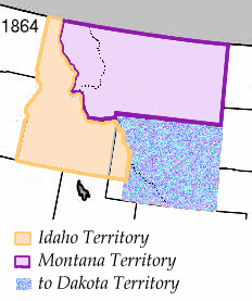
The meridian was first used as a boundary when theMontana Territory
The Territory of Montana was an organized incorporated territory of the United States that existed from May 26, 1864, until November 8, 1889, when it was admitted as the 41st state in the Union as the state of Montana.
Original boundaries
...
was created in 1864. It served as Montana Territory's extreme southwestern boundary. The next usage of the boundary came when the Wyoming Territory
The Territory of Wyoming was an organized incorporated territory of the United States that existed from July 25, 1868, until July 10, 1890, when it was admitted to the Union as the State of Wyoming. Cheyenne was the territorial capital. The bou ...
was established in 1868, with the meridian as its western boundary. It was also at this time that it became much of the then- Idaho Territory's eastern boundary, as well as the extreme northeastern boundary of the then-Utah Territory
The Territory of Utah was an organized incorporated territory of the United States that existed from September 9, 1850, until January 4, 1896, when the final extent of the territory was admitted to the Union as the State of Utah, the 45th state ...
. Montana
Montana () is a state in the Mountain West division of the Western United States. It is bordered by Idaho to the west, North Dakota and South Dakota to the east, Wyoming to the south, and the Canadian provinces of Alberta, British Columb ...
became a state in 1889, with Idaho
Idaho ( ) is a state in the Pacific Northwest region of the Western United States. To the north, it shares a small portion of the Canada–United States border with the province of British Columbia. It borders the states of Montana and Wyomi ...
and Wyoming
Wyoming () is a state in the Mountain West subregion of the Western United States. It is bordered by Montana to the north and northwest, South Dakota and Nebraska to the east, Idaho to the west, Utah to the southwest, and Colorado to the s ...
following the year afterwards. Utah
Utah ( , ) is a state in the Mountain West subregion of the Western United States. Utah is a landlocked U.S. state bordered to its east by Colorado, to its northeast by Wyoming, to its north by Idaho, to its south by Arizona, and to it ...
became a state in 1896.
In the present day, the meridian is used as Wyoming's western border with Montana, Idaho and Utah.
References
{{reflist Borders of Idaho Borders of Montana Borders of Utah Borders of Wyoming Meridians (geography)