|
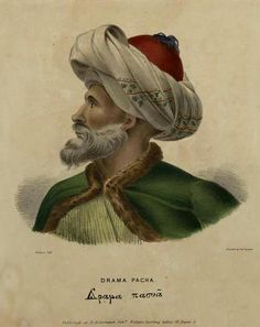
Mahmud Dramali Pasha
Dramalı Mahmud Pasha, ( Turkish: ''Dramalı Mahmut Paşa''; c. 1770 in Istanbul – 26 October 1822, in Corinth) was an Ottoman Albanian statesman and military leader, and a pasha, and served as governor (''wali'') of Larissa, Drama, and the Morea. In 1822, he was tasked with suppressing the Greek War of Independence, but was defeated at the Battle of Dervenakia and died shortly after. Early life and career Mahmud was raised and educated at the Topkapi Palace at Istanbul. He participated in various campaigns throughout the Empire, rising to the rank of vizier and acquiring significant military skills. Enjoying the patronage of the Valide Sultan, he was eventually posted in his family's home province of Drama, succeeding his father Melek Mehmed Pasha as governor. From this he got his sobriquet ''Dramali''. In 1820 he was Pasha of Thessaly at Larissa and participated in the army of Hursid Pasha that was operating against the rebel Ali Pasha of Yannina. In the summer of 1821, ... [...More Info...] [...Related Items...] OR: [Wikipedia] [Google] [Baidu] |
Sanjak Of Tirhala
The Sanjak of Tirhala or Trikala (Ottoman Turkish: ; el, λιβάς/σαντζάκι Τρικάλων) was second-level Ottoman province ( or ) encompassing the region of Thessaly. Its name derives from the Turkish version of the name of the town of Trikala. It was established after the conquest of Thessaly by the Ottomans led by Turahan Bey, a process which began at the end of the 14th century and ended in the mid-15th century. History In the mid-14th century, Thessaly had been ruled by Serbian and Greek lords and enjoyed great prosperity. It was conquered by the Ottoman Turks in successive waves, in 1386/7, the mid-1390s, and again after 1414/23, and the conquest was not completed until 1470. Trikala itself fell probably in 1395/6 (although Evliya Çelebi claims it happened as early as 1390). The newly conquered region was initially the patrimonial domain of the powerful marcher-lord () Turahan Bey (died 1456) and of his son Ömer Bey (died 1484) rather than a regular prov ... [...More Info...] [...Related Items...] OR: [Wikipedia] [Google] [Baidu] |
Patras
) , demographics_type1 = , demographics1_footnotes = , demographics1_title1 = , demographics1_info1 = , demographics1_title2 = , demographics1_info2 = , timezone1 = EET , utc_offset1 = +2 , timezone1_DST = EEST , utc_offset1_DST = +3 , elevation_min_m = 0 , elevation_max_m = 10 , postal_code_type = Postal codes , postal_code = 26x xx , area_code_type = Telephone , area_code = 261 , registration_plate = ΑXx, ΑZx, AOx, AYx , blank_name_sec1 = Patron saint , blank_info_sec1 = Saint Andrew (30 November) , website www.e-patras.gr, official_name = , population_density_rank = Patras ( el, Πάτρα, Pátra ; Katharevousa and grc, Πάτραι; la, Patrae) is Greece's third- ... [...More Info...] [...Related Items...] OR: [Wikipedia] [Google] [Baidu] |
Acrocorinth
Acrocorinth ( el, Ακροκόρινθος), "Upper Corinth", the acropolis of ancient Corinth, is a monolithic rock overseeing the ancient city of Corinth, Greece. In the estimation of George Forrest, "It is the most impressive of the acropolis of mainland Greece." With its secure water supply, Acrocorinth's fortress was repeatedly used as a last line of defense in southern Greece because it commanded the Isthmus of Corinth, repelling foes from entry by land into the Peloponnese peninsula. History The Acrocorinth was continuously occupied from archaic times to the early 19th century. Along with Demetrias and Chalcis, the Acrocorinth during the Hellenistic period formed one of the so-called “''Fetters of Greece''” – three fortresses garrisoned by the Macedonians to secure their control of the Greek city-states. The city's archaic acropolis was already an easily defensible position due to its geomorphology; it was further heavily fortified during the Byzantine Empire as i ... [...More Info...] [...Related Items...] OR: [Wikipedia] [Google] [Baidu] |
Megaris
:''This is also the ancient Greek name of a small island off Naples, site of the Castel dell'Ovo.'' Megaris ( grc, Μεγαρίς) was a small but populous state of ancient Greece, west of Attica and north of Corinthia, whose inhabitants were adventurous seafarers, credited with deceitful propensities. The capital, Megara, was famous for white marble and fine clay. Mount Geraneia dominates the center of the region. The island of Salamis was originally under the control of Megara, before it was lost to Athens in the late 7th century BCE. Province The province of Megaris or Megarida ( el, Επαρχία Μεγαρίδας or ) was one of the provinces of the East Attica Prefecture. Its territory corresponded with that of the current municipalities Aspropyrgos, Eleusis, Mandra-Eidyllia Mandra-Eidyllia ( el, Μάνδρα-Ειδύλλια) is a municipality in the West Attica regional unit, Attica, Greece. The seat of the municipality is the town Mandra. The municipality has ... [...More Info...] [...Related Items...] OR: [Wikipedia] [Google] [Baidu] |
Acropolis
An acropolis was the settlement of an upper part of an ancient Greek city, especially a citadel, and frequently a hill with precipitous sides, mainly chosen for purposes of defense. The term is typically used to refer to the Acropolis of Athens, yet every Greek city had an acropolis of its own. Acropoloi were used as religious centers and places of worship, forts, and places in which the royal and high-status resided. Acropolises became the nuclei of large cities of classical ancient times, and served as important centers of a community. Some well-known acropoloi have become the centers of tourism in present-day, and, especially, the Acropolis of Athens has been a revolutionary center for the studies of ancient Greece since the Mycenaean period. Many of them have become a source of revenue for Greece, and represent some great technology during the period. Origin An acropolis is defined by the Greek definition of ἀκρόπολις, akropolis; from akros (άκρος) or (άκ ... [...More Info...] [...Related Items...] OR: [Wikipedia] [Google] [Baidu] |
Attica
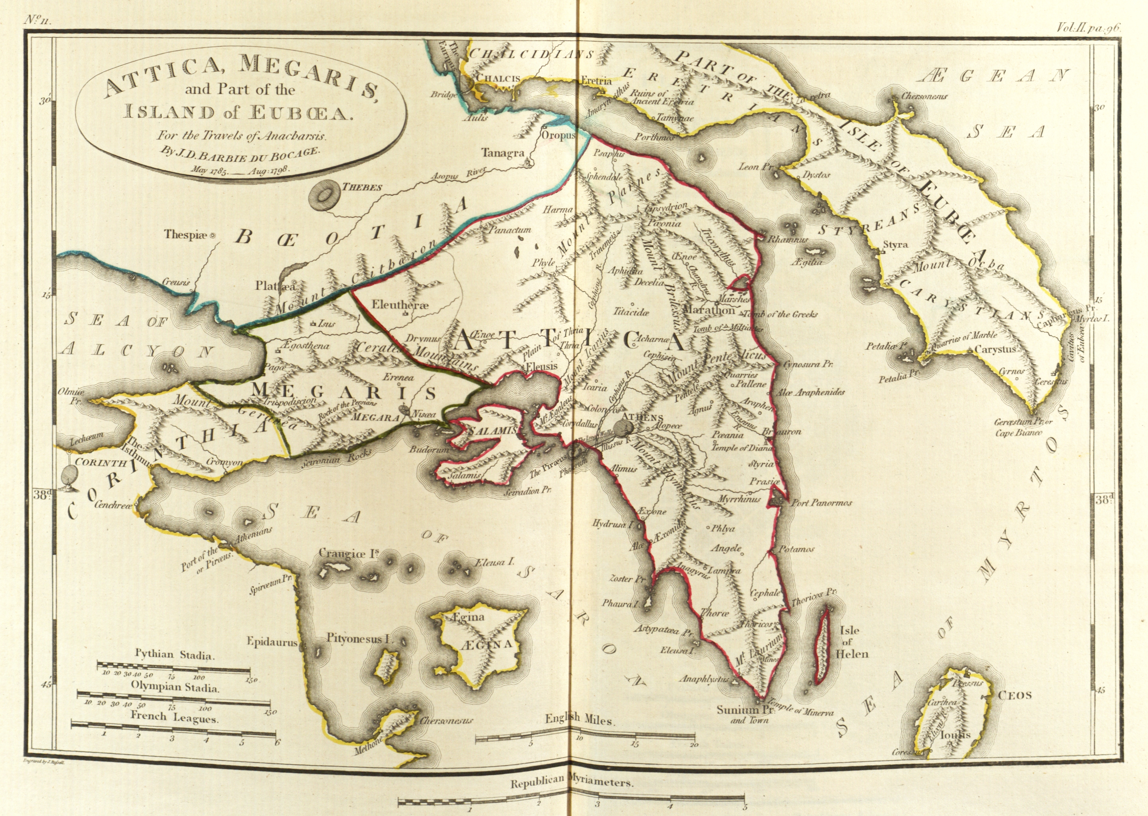
Attica ( el, Αττική, Ancient Greek ''Attikḗ'' or , or ), or the Attic Peninsula, is a historical region that encompasses the city of Athens, the capital of Greece and its countryside. It is a peninsula projecting into the Aegean Sea, bordering on Boeotia to the north and Megaris to the west. The southern tip of the peninsula, known as Laurion, was an important mining region. The history of Attica is tightly linked with that of Athens, and specifically the Golden Age of Athens during the classical period. Ancient Attica ( Athens city-state) was divided into demoi or municipalities from the reform of Cleisthenes in 508/7 BC, grouped into three zones: urban (''astu'') in the region of Athens main city and Piraeus (port of Athens), coastal (''paralia'') along the coastline and inland (''mesogeia'') in the interior. The modern administrative region of Attica is more extensive than the historical region and includes Megaris as part of the regional unit West A ... [...More Info...] [...Related Items...] OR: [Wikipedia] [Google] [Baidu] |
Thebes, Greece
Thebes (; ell, Θήβα, ''Thíva'' ; grc, Θῆβαι, ''Thêbai'' .) is a city in Boeotia, Central Greece. It played an important role in Greek myths, as the site of the stories of Cadmus, Oedipus, Dionysus, Heracles and others. Archaeological excavations in and around Thebes have revealed a Mycenaean settlement and clay tablets written in the Linear B script, indicating the importance of the site in the Bronze Age. Thebes was the largest city of the ancient region of Boeotia and was the leader of the Boeotian confederacy. It was a major rival of ancient Athens, and sided with the Persians during the 480 BC invasion under Xerxes I. Theban forces under the command of Epaminondas ended Spartan hegemony at the Battle of Leuctra in 371 BC, with the Sacred Band of Thebes, an elite military unit of male lovers celebrated as instrumental there. Macedonia would rise in power at the Battle of Chaeronea in 338 BC, bringing decisive victory to Philip II over an alliance of Theb ... [...More Info...] [...Related Items...] OR: [Wikipedia] [Google] [Baidu] |
Boeotia
Boeotia ( ), sometimes Latinized as Boiotia or Beotia ( el, Βοιωτία; modern: ; ancient: ), formerly known as Cadmeis, is one of the regional units of Greece. It is part of the region of Central Greece. Its capital is Livadeia, and its largest city is Thebes. Boeotia was also a region of ancient Greece, from before the 6th century BC. Geography Boeotia lies to the north of the eastern part of the Gulf of Corinth. It also has a short coastline on the Gulf of Euboea. It bordered on Megaris (now West Attica) in the south, Attica in the southeast, Euboea in the northeast, Opuntian Locris (now part of Phthiotis) in the north and Phocis in the west. The main mountain ranges of Boeotia are Mount Parnassus in the west, Mount Helicon in the southwest, Cithaeron in the south and Parnitha in the east. Its longest river, the Cephissus, flows in the central part, where most of the low-lying areas of Boeotia are found. Lake Copais was a large lake in the center of Boe ... [...More Info...] [...Related Items...] OR: [Wikipedia] [Google] [Baidu] |
Mora Valesi
The Eyalet of the Morea ( ota, ایالت موره; Eyālet-i Mōrâ) was a first-level province ('' eyalet'') of the Ottoman Empire, centred on the Peloponnese peninsula in southern Greece. History From the Ottoman conquest to the 17th century The Ottoman Turks overran the Peloponnese between 1458–1460, conquering the last remnants of the Byzantine Empire, with the exception of the Venetian strongholds,Kazhdan (1991), p. 1621 which were taken gradually over decades of intermittent Ottoman–Venetian Wars. Coron and Modon fell in 1500, and by 1540, the Ottoman conquest of the Peloponnese had been completed with the capture of Monemvasia and Nauplion.Bées & Savvides (1993), p. 239Zarinebaf, Bennet & Davis (2005), p. 21 Upon its conquest, the peninsula was made a ''sanjak'' of the Rumelia Eyalet, with its capital first at Corinth (Turk. ''Kordos'' or ''Gördes''), later in Leontari (''Londari''), Mystras (''Mezistre'' or ''Misistire'') and finally in Nauplion (Tr. ''Ana ... [...More Info...] [...Related Items...] OR: [Wikipedia] [Google] [Baidu] |
Mount Pelion
Pelion or Pelium (Modern el, Πήλιο, ''Pílio''; Ancient Greek/Katharevousa: Πήλιον, ''Pēlion'') is a mountain at the southeastern part of Thessaly in northern Greece, forming a hook-like peninsula between the Pagasetic Gulf and the Aegean Sea. Its highest summit, ''Pourianos Stavros'', is amsl. The Greek National Road 38 (GR-38) runs through the southern portion of the peninsula and GR-38A runs through the middle. Geography and economy The mountain is thickly forested, with both deciduous and perennial forests, mainly of beech, oak, maple and chestnut trees, with olive, apple, pear trees and plane tree groves surrounding places with water. Pelion is considered one of the most beautiful mountains in Greece and is a popular tourist attraction throughout the year: hiking trails and stone paths give access to springs, coves and numerous beaches, sandy or pebbly, set among lusciously green slopes. Pelion is an amply watered mountain with an abundance of springs, gor ... [...More Info...] [...Related Items...] OR: [Wikipedia] [Google] [Baidu] |


