|
Toowoomba
Toowoomba ( , nicknamed 'The Garden City' and 'T-Bar') is a city in the Toowoomba Region of the Darling Downs, Queensland, Australia. It is west of Queensland's capital city Brisbane by road. The urban population of Toowoomba as of the 2021 Census was 142,163, having grown at an average annual rate of 1.45% over the previous two decades. Toowoomba is the second-most-populous inland city in the country after the national capital of Canberra and hence the largest city on the Darling Downs, and it is among the largest regional centres in Queensland. It is also referred to as the capital of the Darling Downs. The Toowoomba region is the home of two main Aboriginal language groups, the Giabal whose lands extend south of the city and Jarowair whose lands extend north of the city. The Jarowair lands include the site of one of Australia's most important sacred Bora ceremonial ground, the ‘Gummingurru stone arrangement’ dated to c.4000 BC. The site marked one of the major route ... [...More Info...] [...Related Items...] OR: [Wikipedia] [Google] [Baidu] |
Laurel Bank Park
Laurel Bank Park is a heritage-listed park at the corner of West Street, Hill Street and Herries Street, Toowoomba City, Toowoomba, Toowoomba Region, Queensland, Australia. It was built from 1904 to 1943. It was added to the Queensland Heritage Register on 30 November 2018. History Laurel Bank Park is a public park situated approximately southwest of Toowoomba railway station. It is bounded by Herries, West and Hill streets. The park was donated to the City of Toowoomba in 1932 by local resident Samuel George Stephens (junior), after almost thirty years of developing the beautiful gardens. Within the park are many cold-climate mature trees considered of horticultural importance. Two croquet lawns and a croquet clubhouse were added to the park in the 1930s. During World War II (WWII) the park was used as a United States Navy (USN) submariners' rest and recreation camp. The intact former mess hall is the only building remaining from the camp in the park. Since the 1930s, th ... [...More Info...] [...Related Items...] OR: [Wikipedia] [Google] [Baidu] |
Toowoomba City Hall
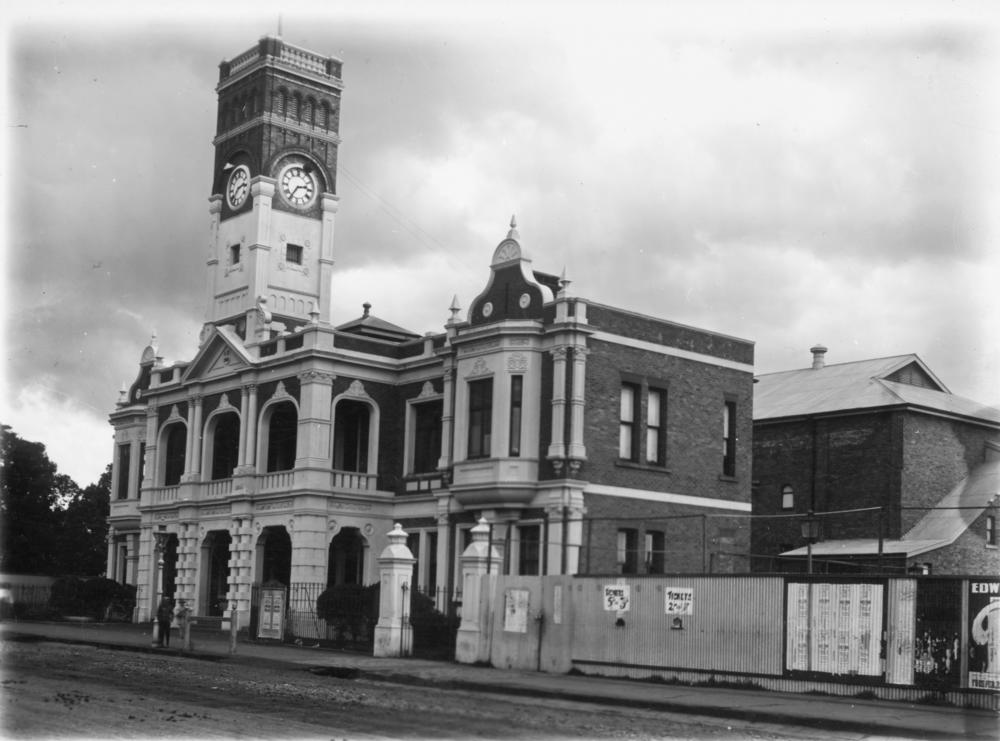
Toowoomba City Hall is a heritage-listed town hall at 541 Ruthven Street, Toowoomba, Toowoomba Region, Queensland, Australia. It was designed by Willoughby Powell and built in 1900 by Alexander Mayne. It is also known as Toowoomba Town Hall. It was added to the Queensland Heritage Register on 21 October 1992. It is the third town hall in Toowoomba and the building was the location for the proclamation that Toowoomba was a city and was the first purpose built city hall ever constructed in Queensland. History Toowoomba City Hall, the city's third town hall, was built in 1900 to a design by Willoughby Powell on the site of the School of Arts. When first constructed, City Hall incorporated municipal offices and council chambers, rooms for a school of arts, a technical college and public hall. The first settlement in the Toowoomba area was established on the present site of Drayton in 1842, and a mail service commenced in December 1845. A survey of Drayton in 1850, the third to ... [...More Info...] [...Related Items...] OR: [Wikipedia] [Google] [Baidu] |
Toowoomba Bypass
The Toowoomba Bypass, known as Toowoomba Second Range Crossing during planning and construction, is a grade separated, dual carriageway bypass and partial ring road constructed to the north and west of Toowoomba, Queensland. Construction commenced in April 2016. It opened to traffic on 8 September 2019. History The city of Toowoomba is situated on a plateau on the edge of the Great Dividing Range. A defining characteristic of the city is its high position on an escarpment of the range, which enjoys sweeping views of the Lockyer Valley below. The existing range road was completed in its current alignment in 1939. This road has unfavourable road geometry including tight corners and a rate of climb as high as 10.5%. The Warrego Highway is a major Brisbane- Darwin highway that passes through Toowoomba and utilises the existing range road. The Gore Highway is a major freight corridor that travels from Melbourne (via the Newell Highway and the Goulburn Valley Highway) and terminates ... [...More Info...] [...Related Items...] OR: [Wikipedia] [Google] [Baidu] |
Toowoomba Region
The Toowoomba Region is a local government area located in the Darling Downs part of Queensland, Australia. Established in 2008, it was preceded by several previous local government areas with histories extending back to the early 1900s and beyond. In 2018-2019, it had a A$491 million budget, of which A$316 million is for service delivery and A$175.13 million capital (infrastructure) budget. History Prior to the 2008 amalgamation, the Toowoomba Region existed as eight distinct local government areas: the City of Toowoomba and the Shires of Cambooya, Clifton, Crows Nest, Jondaryan, Millmerran, Pittsworth, and Rosalie. The City had its beginning in the Toowoomba Municipality which was proclaimed on 24 November 1860 under the ''Municipalities Act 1858'', a piece of New South Wales legislation inherited by Queensland when it became a separate colony in 1859. William Henry Groom, sometimes described as the "father of Toowoomba", was elected its first mayor. It achieved a meas ... [...More Info...] [...Related Items...] OR: [Wikipedia] [Google] [Baidu] |
Toowoomba Chronicle
''The Toowoomba Chronicle'' is a daily newspaper serving Toowoomba, the Lockyer Valley and Darling Downs regional areas in Queensland, Australia. As of 2016, the newspaper is owned by News Corp Australia, and forms part of their Regional Media network. In 2008, the audited circulation of ''The Toowoomba Chronicle'' was 22,808 Monday to Friday and 30,270 on Saturday. History The ''Darling Downs Gazette'', founded at Drayton by Arthur Sidney Lyon, began publication in a wooden shanty on 10 June 1858. It moved to the burgeoning town of Toowoomba and merged with ''The Chronicle'' in 1922. The ''Chronicle'', founded by Darius Hunt, began as a fourpenny weekly on 4 July 1861 in a coachbuilder's shop in James Street. On 4 February 1876, William Henry Groom became sole proprietor, beginning nearly half a century of family control of a newspaper that he transformed into a powerful and persuasive political weapon. Archibald Meston was one of the editors. In 1922 the Dunn family a ... [...More Info...] [...Related Items...] OR: [Wikipedia] [Google] [Baidu] |
Queens Park, Toowoomba
Queens Park is a heritage-listed botanic garden at 43-79 Lindsay Street, East Toowoomba, Toowoomba, Queensland, Toowoomba Region, Australia. It was built from 1875 to 1970s. It also contains the Toowoomba Botanic Gardens. It was added to the Queensland Heritage Register on 27 April 2001. History The Queen's Park and Botanic Gardens, Toowoomba was gazetted as a public reserve in 1869. It was not until the mid 1870s that the Queens Park and Botanic Gardens were established as separate, but related, entities on this land. Queens Park was intended as a place of public recreation and the Botanic Gardens as a place for botanic research. Urban public parks became a popular vehicle for 19th century movements concerned with public health - the park provided a place for the outdoor recreation of those unable to afford private gardens and improved the environment of crowded central city and town areas. Botanic Gardens were started as part of an increasing interest in scientific underst ... [...More Info...] [...Related Items...] OR: [Wikipedia] [Google] [Baidu] |
County Of Aubigny
The County of Aubigny is a county (a cadastral division) in Queensland, Australia. Like all counties in Queensland, it is a non-functional administrative unit, that is used mainly for the purpose of registering land titles. The county lies between 151°E and 152°E longitude, and it covers the Toowoomba Region and the Dalby part of the Western Downs Region, at Queensland Archives. The county was named by the Surveyor-General of New South Wales in 1850, possibly to honour the who had a long association with the name Aubigny. The area was officially named and bounded by t ... [...More Info...] [...Related Items...] OR: [Wikipedia] [Google] [Baidu] |
Toowoomba Court House
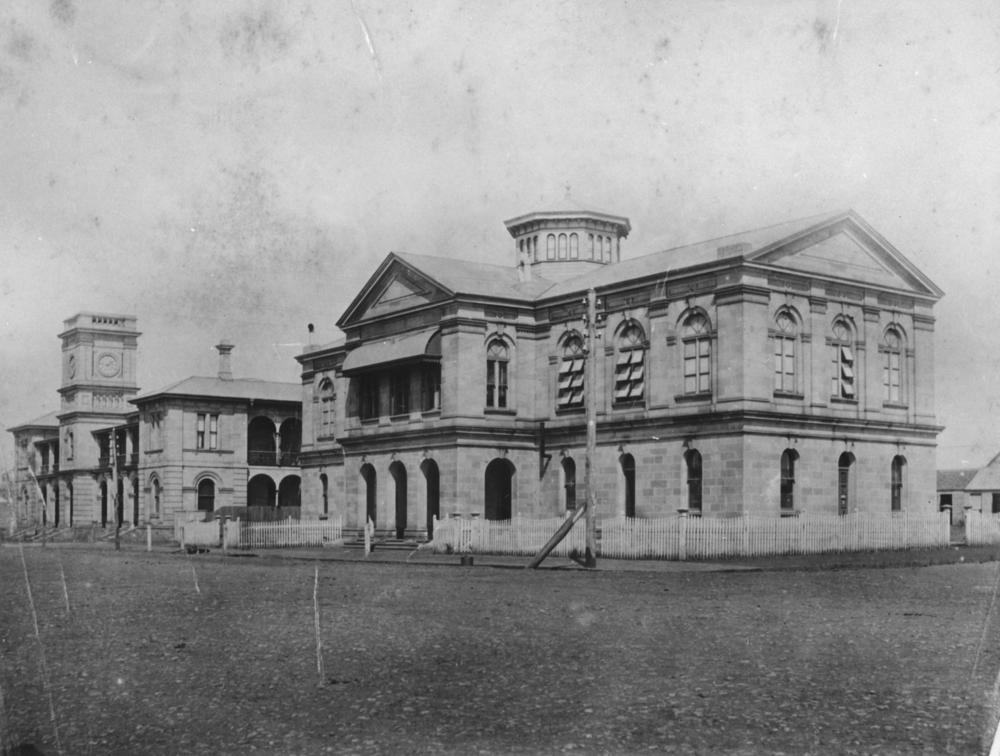
Toowoomba Court House is a heritage-listed former courthouse at 46 Neil Street, Toowoomba, Queensland, Australia. It was designed by Francis Drummond Greville Stanley and built from 1876 to 1943. It was added to the Queensland Heritage Register on 21 October 1992. History The main section of the Toowoomba Court House was erected between 1876 and 1878. At the time of its construction, the Queensland Colonial Architect responsible for the design of public buildings was F D G Stanley. Toowoomba is the principal town on the Darling Downs which was first discovered by explorer Allan Cunningham in 1827. It was later settled by pastoralists in search of rich grazing land and by the 1840s, led by the Leslie brothers and John Campbell over twenty stations had been established. The first township which evolved to support these stations was Drayton, west of Toowoomba. Within ten years, the town had been established as a "government town", with much support from the local squatters. ... [...More Info...] [...Related Items...] OR: [Wikipedia] [Google] [Baidu] |
Electoral District Of Toowoomba South
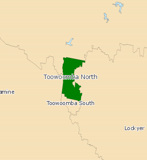
Toowoomba South is an electoral district of the Legislative Assembly in the Australian state of Queensland. It was created with the 1972 redistribution, and replaced the abolished Toowoomba East. The electorate covers the eastern and inner southern suburbs of Toowoomba. It excludes the outer southern suburbs of Toowoomba, Drayton, Darling Heights and the other areas near the University of Southern Queensland, which fall in Condamine. It is part of the Darling Downs group of seats, and is bounded on the east by Lockyer, the north by Toowoomba North, and on the south and west by Condamine. The electorate was held by John McVeigh for the Liberal National Party, until his resignation on 29 April 2016 to contest the federal seat of Groom at the 2016 federal election. David Janetzki was elected at the subsequent by-election A by-election, also known as a special election in the United States and the Philippines, a bye-election in Ireland, a bypoll in India, or a Zimni ... [...More Info...] [...Related Items...] OR: [Wikipedia] [Google] [Baidu] |
Darling Downs
The Darling Downs is a farming region on the western slopes of the Great Dividing Range in southern Queensland, Australia. The Downs are to the west of South East Queensland and are one of the major regions of Queensland. The name was generally applied to an area approximating to that of the Condamine River catchment upstream of Condamine township but is now applied to a wider region comprising the Southern Downs, Western Downs, Toowoomba and Goondiwindi local authority areas. The name Darling Downs was given in 1827 by Allan Cunningham, the first European explorer to reach the area and recognises the then Governor of New South Wales, Ralph Darling. The region has developed a strong and diverse agricultural industry largely due to the extensive areas of vertosols (cracking clay soils), particularly black vertosols, of moderate to high fertility and available water capacity. Manufacturing and mining, particularly coal mining are also important, and coal seam gas extracti ... [...More Info...] [...Related Items...] OR: [Wikipedia] [Google] [Baidu] |
Clifford House, Toowoomba
Clifford House is a heritage-listed club house at 120 Russell Street, Toowoomba, Toowoomba Region, Queensland, Australia. It was built . It was added to the Queensland Heritage Register on 21 October 1992. History This two-storeyed building, intended for use as a gentlemen's club, was erected in the mid-1860s on land owned by the Hon James Taylor in Russell Street, Toowoomba. The land on which Clifford House stands had been granted to William Horton in 1852, and was acquired by Taylor and his partner in Cecil Plains station, Henry Stuart Russell in 1855. Taylor is considered to have been the driving force behind Toowoomba's development, as he invested heavily in land in Toowoomba particularly during the late 1850s. Taylor took a leading role in encouraging the social, cultural and economic development of Toowoomba, donating land to various groups and churches, and he came to be regarded as "the King of Toowoomba". Taylor was Mayor of Toowoomba in 1890, and was a Member of ... [...More Info...] [...Related Items...] OR: [Wikipedia] [Google] [Baidu] |
Electoral District Of Toowoomba North
Toowoomba North is an electoral district of the Legislative Assembly in the Australian state of Queensland. It was created with the 1972 redistribution. It replaced the abolished electorate of Toowoomba West. Toowoomba North is largely based around the upper half of the city of Toowoomba. It covers the suburbs north of James Street, including Newtown, Wilsonton, Mount Lofty, etc. It also includes the urban fringe area of Blue Mountain Heights, the satellite town of Highfields and Spring Bluff. It excludes certain western localities of Toowoomba, which are in the Electoral district of Condamine. The electorate is currently represented by Trevor Watts of the Liberal National Party of Queensland The Liberal National Party of Queensland (LNP) is a major political party in Queensland, Australia. It was formed in 2008 by a merger of the Queensland divisions of the Liberal Party and the National Party. At a federal level and in most other .... Members for Toowoomba Nort ... [...More Info...] [...Related Items...] OR: [Wikipedia] [Google] [Baidu] |
.jpg)


